|
|
|
Scheffer, Thassilo von
Die Kultur der Griechen.
Wien : Phaidon-Verl., 1935. 647 S. 233 Taf. 4°. Große ill. Phaidon-Ausg. OPpbd. mit Goldpräg.
Riferimento per il libraio : 3545
|
|
|
Scheffler, Karl
Meister des schönen Handwerks. Aus vier Jahrhunderten Europäischer Malerei
Gallus Verlag, Wien, 1940. 206 S.; zahlr. Abb, Pp.
Riferimento per il libraio : 25101
|
|
|
Scheffler, Karl
Paris.
Lpz., Insel 1928. 8°. 263 S. OLn. - Einband bestaubt u. etwas gedunkelt. OLn.
Riferimento per il libraio : 14640AB
|
|
|
Schefold Karl
Grecia classica
71 illustrazioni in nero, 77 disegni, 1 carta geografica 50 tavole a colori

|
|
|
Scheibe, Paul
Die rechtliche Stellung des Kirchenvorstandes in der evangelisch-lutherischen Landeskirche des Königreichs Sachsen. Inaugural-Dissertation ... bei der Universität Leipzig.
Borna - Leipzig Druck bei Noske 1906. Original-Broschur mit papierverstärktem Rücken IX, 83 Seiten. etwas angestaubt, wenig knickspurig, innen sauber
Riferimento per il libraio : 1121419
|
|
|
Scheibelreiter, Georg
Die barbarische Gesellschaft : Mentalitätsgeschichte der europäischen Achsenzeit 5. - 8. Jahrhundert. ERSTAUSGABE.
Darmstadt : Primus-Verlag, 1999. 661 Seiten Mit Schwarz-Weiß- Abbildungen ; 25 cm Originalpappband mit Original-Schutzumschlag.
Riferimento per il libraio : 308488

|
|
|
Scheibelreiter, Georg
Die barbarische Gesellschaft : Mentalitätsgeschichte der europäischen Achsenzeit 5. - 8. Jahrhundert.
Darmstadt : Wiss. Buchges., WBG (Wissenschaftliche Buchgesellschaft) 1999. 661 S. : Kt. ; 25 cm, mit Schutzumschlag gebundene Ausgabe, Hardcover/Pappeinband, Exemplar in gutem Erhaltungszustand
Riferimento per il libraio : 42866

|
|
|
Scheibelreiter, Georg (Mitwirkender)
Höhepunkte des Mittelalters. Georg Scheibelreiter (Hg.)
Augsburg : Weltbild, 2011. 256 S. : graph. Darst. Gr.-8°, Hardcover/Pappeinband
Riferimento per il libraio : 140257

|
|
|
Scheikevitch, Jacques Thalberg von
Impromtu. Aufzeichnungen für den Ricerca Trust. Apercus pour le Ricerca Trust.
Thomas-Verlag; Zürich, 1956. 126 Seiten; Illustr.; 21,5 cm; fadengeh. Orig.-Pappband m. Schutzumschlag.
Riferimento per il libraio : 1228528

|
|
|
SCHEINOWITZ, A.S.
De Terre et de Larmes.
grand in-8°, 254 pages, broche, couverture illustree plast. Tres bel exemplaire. [109B-5]
|
|
|
Scheiwiller Giovanni
Hermann Haller
30 tavole in nero fuori testo

|
|
|
Schelbert, Urspeter (Red.):
Ich war in einer fürchterlichen Angst und Verwirrung, es machte entsetzlich in mir... Kindsmordprozesse in Uri im 19. Jahrhundert (= Der Geschichtsfreund, 156. Band).
23,5 x 16,5 cm. 276 Seiten. Gebundene Ausgabe mit Schutzumschlag (sehr gut). ISBN 9783906130248 Bücher de
|
|
|
Schelling, J
De hoge bosgronden van Midden-Nederland. (= Mededelingen van de Stichting voor Bodemkartering / Bodemkundige Studies, No. 5).
STIBOKA (Stichting voor Bodemkartering), Wageningen 1960. 67 S. mit Abbildungen und in 6 Tasche beiliegenden mehrfach gefalteten Tafeln und Karten, Groß 8°, Original-Karton (Softcover), Einband leicht randstaubig, Vorsatz mit Namensstempel, insgesamt gutes und innen sauberes Exemplar mit allen Beilagen,
Riferimento per il libraio : 70869

|
|
|
SCHELTEMA, Frederik Adam van
Die Kunst der Vorzeit.
Stgt.,Kohlhammer (1950). gr.8°. 207 S. Mit 1 Farbtaf., XLVIII schw.-w. Taf. u. 60 Abb. im Text. Illustr. Oln. Schnitt etwas staubfleckig, durchgänig leicht stockfleckig, Seiten papierbedingt etwas nachgedunkelt, sonst gut erhalten.
Riferimento per il libraio : R1841-97

|
|
|
Schelter, Kurt
Arbeits- und Sozialrecht der Europäischen Union (EU) : Fundstellen- und Inhaltsnachweis.
Starnberg : Schulz, 1995. 381 S. 4°. 7. Aufl. - Stand: 1. Januar 1995. OBroschur.
Riferimento per il libraio : 26609
|
|
|
Schelter, Kurt
Arbeits- und Sozialrecht der Europäischen Union (EU) : Fundstellen- und Inhaltsnachweis.
Starnberg : Schulz, 1994. 297 S. 4°. 6. Aufl. - Stand: 1. Juli 1994. OBroschur.
Riferimento per il libraio : 26608
|
|
|
Schelting, Alexander von
Rußland und Europa im russischen Geschichtsdenken : auf der Suche nach der historischen Identität. Neu hrsg. und mit einem Nachw. von Christiane Uhlig / Russische Bibliothek
Bern, A. Francke AG. Verlag 1948. 404 S. ; 23 cm, mit Schutzumschlag, Schutzumschlag mit leichten Gebrauchsspuren gebundene Ausgabe, Leinen, Exemplar in gutem Erhaltungszustand
Riferimento per il libraio : 50151

|
|
|
SCHENDELL, WERNER.
Wilhelm von Oranien. Befreier der Niederlande. Eine Biographie von Werner Schendell.
Mit 21 Abbildungen nach zeitgenössischen Stichen.
|
|
|
SCHENK Pieter (1660 - 1718 ca.)
Altenburg in Meissen, te zien van den weg naar Glaucha. - Altenburgum, urbs in Mifnia, qua prospectus ad eam est versus Glau
Rara veduta della città tratta dal famoso atlante di città dello Schenk, denominato "Hecatompolis, sive Totius orbis Terrarum Oppida Nobiliora Centum; exquisite collecta atque eleganter depicta" stampato ad Amsterdam nel 1702. La veduta riconosce come fonte la produzione vedutistica francese coeva (Aveline, Chereau le Jeune, Carel Allard) che a sua volta si rifà al prototipo di Braun e Hegenberg; essa risulta tuttavia personalizzata da un'efficace ed accurata resa grafica, attribuibile alla mano esperta di un incisore dell'officina di Peter Schenk. In basso l'intitolazione è riportata in lingua olandese e latina e si legge il nome dell'editore. L'esemplare ha prodotto numerose filiazioni per tutto il Settecento ed oltre, per cui puó essere a sua volta considerato un prototipo. Peter Schenk (Elberfeld 1645 - 1715), fu un noto incisore e editore olandese, allievo di Gerard Valck ad Amsterdam, ne sposò la figlia e insieme a lui comprò molte lastre della ditta Blaeu nel 1683. Produsse vari atlanti e raccolte di piante e vedute di città, per le quali incise molte nuove carte: ai primi del Settecento fu nominato incisore di corte da Augusto di Sassonia, produsse infatti molti ritratti di personaggi famosi; molte incisioni uscite dalla sua stamperia, che nel frattempo si era notevolmente allargata ed ospitava i migliori incisori del tempo, portano la sua firma soltanto come editore. Alla sua morte l'attività fu continuata dal figlio Peter, detto il Giovane.Incisione in rame, in ottimo stato di conservazione. This is a rare view from Schenk's important town atlas, called "Hecatompolis, sive Totius orbis Terrarum Oppida Nobiliora Centum; exquisite collecta atque eleganter depicta". The veduta recognizes as a source the contemporary French production (Aveline, Chereau le Jeune, Carel Allard) which in turn is based on the prototype of Braun and Hegenberg; however, it is personalized by an effective and accurate graphic rendering, attributable to the expert hand of an engraver of Peter Schenk's workshop.Below the title is in Dutch and Latin and you can read the name of the publisher. The exemplar has produced numerous subsidiaries throughout the eighteenth century and beyond, so it can also be considered a prototype.Peter Schenk (Elberfeld 1645 - 1715), a well-known Dutch engraver and publisher, was a pupil of Gerard Valck in Amsterdam, married his daughter and together with him bought many slabs of the Blaeu company in 1683. He produced various atlases and collections of plants and city views, for which he engraved many new maps: at the beginning of the eighteenth century he was appointed court engraver by Augustus of Saxony, he produced many portraits of famous people, many engravings from his printing house, which in the meantime had expanded considerably and housed the best engravers of the time, bear his signature only as a publisher. At his death the activity was continued by his son Peter, called the Younger.Copperplate, good condition.

|
|
|
SCHENK Pieter (1660 - 1718 ca.)
Derbent…
Rara veduta della città di Derbent, sul Mar Caspio; tratta dal famoso atlante di città dello Schenk, denominato "Hecatompolis, sive Totius orbis Terrarum Oppida Nobiliora Centum; exquisite collecta atque eleganter depicta" stampato ad Amsterdam nel 1702.La veduta riconosce come fonte la produzione vedutistica francese coeva (Aveline, Chereau le Jeune, Carel Allard) che a sua volta si rifà al prototipo di Braun e Hegenberg; essa risulta tuttavia personalizzata da un'efficace ed accurata resa grafica, attribuibile alla mano esperta di un incisore dell'officina di Peter Schenk.In basso l'intitolazione è riportata in lingua olandese e latina e si legge il nome dell'editore. L'esemplare ha prodotto numerose filiazioni per tutto il Settecento ed oltre, per cui puó essere a sua volta considerato un prototipo.Peter Schenk (Elberfeld 1645 - 1715), fu un noto incisore e editore olandese, allievo di Gerard Valck ad Amsterdam, ne sposò la figlia e insieme a lui comprò molte lastre della ditta Blaeu nel 1683. Produsse vari atlanti e raccolte di piante e vedute di città, per le quali incise molte nuove carte: ai primi del Settecento fu nominato incisore di corte da Augusto di Sassonia, produsse infatti molti ritratti di personaggi famosi; molte incisioni uscite dalla sua stamperia, che nel frattempo si era notevolmente allargata ed ospitava i migliori incisori del tempo, portano la sua firma soltanto come editore. Alla sua morte l'attività fu continuata dal figlio Peter, detto il Giovane.Incisione in rame, in ottimo stato di conservazione. This is a rare view from Schenk's important town atlas, called "Hecatompolis, sive Totius orbis Terrarum Oppida Nobiliora Centum; exquisite collecta atque eleganter depicta". The veduta recognizes as a source the contemporary French production (Aveline, Chereau le Jeune, Carel Allard) which in turn is based on the prototype of Braun and Hegenberg; however, it is personalized by an effective and accurate graphic rendering, attributable to the expert hand of an engraver of Peter Schenk's workshop.Below the title is in Dutch and Latin and you can read the name of the publisher. The exemplar has produced numerous subsidiaries throughout the eighteenth century and beyond, so it can also be considered a prototype.Peter Schenk (Elberfeld 1645 - 1715), a well-known Dutch engraver and publisher, was a pupil of Gerard Valck in Amsterdam, married his daughter and together with him bought many slabs of the Blaeu company in 1683. He produced various atlases and collections of plants and city views, for which he engraved many new maps: at the beginning of the eighteenth century he was appointed court engraver by Augustus of Saxony, he produced many portraits of famous people, many engravings from his printing house, which in the meantime had expanded considerably and housed the best engravers of the time, bear his signature only as a publisher. At his death the activity was continued by his son Peter, called the Younger.Copperplate, good condition.

|
|
|
SCHENK Pieter (1660 - 1718 ca.)
Le Royaume de Boheme divisée en ses douze cercles Carte Rediute Sur celle de 25 Feuilles par I.C. Muller Capit. et…
Mappa fine e dettagliata che mostra il Regno di Boemia secondo la fonte cartografica di Johann Christian Müller con le vicine Baviera, Sassonia, Austria e Slesia. Nell'angolo in alto a destra una bella incisione allegorica raffigurante una scena di guerra e nell'angolo in basso a sinistra un cartiglio contentente una legenda con simboli e spiegazioni. I dodici cerchi del regno di Boemia sono evidenziati da zone colorate. Sono presenti molti nomi di luoghi, città e villaggi, castelli, fiumi, montagne, laghi. Sono mostrate anche le strade tra le città principali.Esemplare tratta dall'Atlas Novus di Reiner & Joshua Ottes, che acquistarono i rami della tipografia Schenk. Copper engraving, hand colored. A fine and detailled engraved map showing the kingdom of Bohemia after the cartographic source by Johann Christian Müller with the neighboring parts of Bavaria, Saxonia, Austria and Silesia.In the upper right corner is a fine allegoric engraving depicting a war scene and in the lower left corner a table with explanations. The twelve circles of the kingdom of Bohemia are detailled shown in their borders in contemporary body hand color. With many engraved place names of cities and villages, castles, rivers, mountains, lakes. A fine example from the Atlas Novus by. Reiner & Joshua Ottes.

|
|
|
SCHENK Pieter (1660 - 1718 ca.)
Leeuwarden, de voornaamste Stand in Friesland,tuffen Franiker en Dokkom gelegen
Rara veduta tratta da Hecatompolis, sive Totius orbis Terrarum Oppida Nobiliora Centum; exquisite collecta atque eleganter depicta, il famoso atlante delle città di Schenk, stampato ad Amsterdam nel 1702. La veduta riconosce come fonte la produzione vedutistica francese coeva (Aveline, Chereau le Jeune, Carel Allard) che, a sua volta, si rifà al prototipo di Braun e Hogenberg; l’esemplare risulta, tuttavia, personalizzato da un'efficace ed accurata resa grafica, attribuibile alla mano esperta di un incisore dell'officina di Peter Schenk. L'intitolazione è riportata in basso, in lingua olandese e latina; si legge anche il nome dell'editore. La stampa può essere considerata un prototipo in seguito alle sue numerose filiazioni durante tutto l’arco del Settecento. Incisione in rame, in ottimo stato di conservazione. This is a rare view from Schenk's important town atlas, called Hecatompolis, sive Totius orbis Terrarum Oppida Nobiliora Centum; exquisite collecta atque eleganter depicta. The view recognizes as a source the contemporary French production (Aveline, Chereau le Jeune, Carel Allard) which in turn is based on the prototype of Braun and Hogenberg; however, it is personalized by an effective and accurate graphic rendering, attributable to the expert hand of an engraver of Peter Schenk's workshop. Below, the title is in Dutch and Latin and it’s possibile to read the name of the publisher. The exemplar has produced numerous subsidiaries throughout the eighteenth century and beyond, so it can also be considered a prototype. Copperplate, good condition.

|
|
|
SCHENK Pieter (1660 - 1718 ca.)
Leiden, beroemt door zyn Hoope schole,gelegen in Hollant, op den verftopten Ryn
Rara veduta tratta da Hecatompolis, sive Totius orbis Terrarum Oppida Nobiliora Centum; exquisite collecta atque eleganter depicta, il famoso atlante delle città di Schenk, stampato ad Amsterdam nel 1702. La veduta riconosce come fonte la produzione vedutistica francese coeva (Aveline, Chereau le Jeune, Carel Allard) che, a sua volta, si rifà al prototipo di Braun e Hogenberg; l’esemplare risulta, tuttavia, personalizzato da un'efficace ed accurata resa grafica, attribuibile alla mano esperta di un incisore dell'officina di Peter Schenk. L'intitolazione è riportata in basso, in lingua olandese e latina; si legge anche il nome dell'editore. La stampa può essere considerata un prototipo in seguito alle sue numerose filiazioni durante tutto l’arco del Settecento. Incisione in rame, in ottimo stato di conservazione. This is a rare view from Schenk's important town atlas, called Hecatompolis, sive Totius orbis Terrarum Oppida Nobiliora Centum; exquisite collecta atque eleganter depicta. The view recognizes as a source the contemporary French production (Aveline, Chereau le Jeune, Carel Allard) which in turn is based on the prototype of Braun and Hogenberg; however, it is personalized by an effective and accurate graphic rendering, attributable to the expert hand of an engraver of Peter Schenk's workshop. Below, the title is in Dutch and Latin and it’s possibile to read the name of the publisher. The exemplar has produced numerous subsidiaries throughout the eighteenth century and beyond, so it can also be considered a prototype. Copperplate, good condition.

|
|
|
SCHENK Pieter (1660 - 1718 ca.)
Mappa Geographica Exactissima Continens Imperatoris Haereditarium Dominium Silesiam, nec non eiusdem Provincias interiores D
Mappa della Slesia, in Polonia, incisa ad Amsterdam da Peter Schenk.Tratta dell'Atlas Contractus sive Mapparum Geographicarum Sansoniarum auctarum et correctarum Nova Congeries. Amsterdam, P. Schenk, c. 1700.La mappa mostra la Slesia alla fine del 17 ° secolo sotto il regno degli Asburgo.Incisione su rame, coloritura coeva, in buone econdizioni. Scarce map of Silesia, in Poland, engraved in Amsterdam by Peter Schenk.The map shows Silesia at the end of the 17th century under Habsburg Rule.Map taken from Atlas Contractus sive Mapparum Geographicarum Sansoniarum auctarum et correctarum Nova Congeries. Amsterdam, P. Schenk, c. 1700.Copper engraving, old color.

|
|
|
SCHENK Pieter (1660 - 1718 ca.)
Namurcum, Nam, Regio,opp, ad Mosce Sabisque confluentes, loci natura muntissimum.
Rara veduta tratta da Hecatompolis, sive Totius orbis Terrarum Oppida Nobiliora Centum; exquisite collecta atque eleganter depicta, il famoso atlante delle città di Schenk, stampato ad Amsterdam nel 1702. La veduta riconosce come fonte la produzione vedutistica francese coeva (Aveline, Chereau le Jeune, Carel Allard) che, a sua volta, si rifà al prototipo di Braun e Hogenberg; l’esemplare risulta, tuttavia, personalizzato da un'efficace ed accurata resa grafica, attribuibile alla mano esperta di un incisore dell'officina di Peter Schenk. L'intitolazione è riportata in basso, in lingua olandese e latina; si legge anche il nome dell'editore. La stampa può essere considerata un prototipo in seguito alle sue numerose filiazioni durante tutto l’arco del Settecento. Incisione in rame, in ottimo stato di conservazione. This is a rare view from Schenk's important town atlas, called Hecatompolis, sive Totius orbis Terrarum Oppida Nobiliora Centum; exquisite collecta atque eleganter depicta. The view recognizes as a source the contemporary French production (Aveline, Chereau le Jeune, Carel Allard) which in turn is based on the prototype of Braun and Hogenberg; however, it is personalized by an effective and accurate graphic rendering, attributable to the expert hand of an engraver of Peter Schenk's workshop. Below, the title is in Dutch and Latin and it’s possibile to read the name of the publisher. The exemplar has produced numerous subsidiaries throughout the eighteenth century and beyond, so it can also be considered a prototype. Copperplate, good condition.

|
|
|
Schenk, Martin und Michaela Moser
Es reicht! Für alle! Wege aus der Armut.
Wien: Deuticke, 2010. 236 S. kart., engl. broschiert.
Riferimento per il libraio : 78342

|
|
|
Schenk, Pieter d. Älteren
Diversa Orbis terrae visu incedente? 1706
Saarbrücken, Fines Mundi Verlag, 2013. 4°, Unveränderter Faksimilereprint, 2013; Original erschienen 1706 in Amsterdam; Bezahlung per PayPal möglich, we accept PayPal, Halbleinen
Riferimento per il libraio : 34783
|
|
|
Schepeler, [Andreas Daniel Berthold] von
Beiträge zu der Geschichte Spaniens. Enthaltend: Ideen und Notizen über Künste und spanische Maler; unbekannte Dokumente; betreffend Karl V., Filip II. , Don Sebastian von Portugal, den Infanten Don Karlos, Don Juan von Östereich, den Herzog Alba, die unüberwindliche Flotte etc..
Aachen und Leipzig, J. A. Mayer, 1828. Halbleinen
Riferimento per il libraio : 33035

|
|
|
Scheppach, J[oseph] A
Romfahrt im Sommer 1867.
Augsburg, Kranzfelder'sche Buchhandlung, 1868. Ca. 22 x 14 cm. 46 S., (2) Seiten. Orig.-Broschur.
Riferimento per il libraio : 52428AB

|
|
|
SCHERER Henrick (Dilingen 1628 - Monaco 1704)
E Cyclis Denis Unitis nascitur Unum Germanu Imperium, nulla quod arma timet
Decorativa carta geografica pubblicata nell'opera di Heinrich Scherer Atlas Novus exhibens orbem terraguem per naturae opera, historiae navae acveterus monumenta, artistique geographicae leges et praecepta edita in 8 parti, stampate tra il 1702 e il 1710 a Monaco di Baviera. Heinrich Scherer, professore di matematica a Monaco di Baviera, era un gesuita devoto la cui opera sottolineava la gerarchia cattolica e la diffusione delle missioni gesuite in tutto il mondo. Il suo Atlas Novus contiene mappe di tutte le altre parti che mostravano la diffusione del cattolicesimo e delle missioni gesuite. Le 180 mappe incluse in questo lavoro sono state preparate tra il 1699 e il 1700 e sono state incise da Leonard Hecknaeur, Joseph Montelegre e Matthus Wolfgang; ogni volume è introdotto da splendidi frontespizi allegorici dagli stessi incisori. Incisione su rame, in ottimo stato di conservazione. Very decorative map of the German empire, by Heinrich Scherer (1628-1704) for his Atlas Novus exhibens orbem terraguem per naturae opera, historiae navae acveterus monumenta, artistique geographicae leges et praecepta...published in eight volumes from 1702-1710 in Munich. Scherer, a devout Jesuit, produced this geographical compendium to depict the Catholic hierarchy and the spread of Jesuit missions throughout the world. Copper engraving, in very good condition.

|
|
|
SCHERER Henrick (Dilingen 1628 - Monaco 1704)
Europa Orbis Christiani Domina 1699
Bella carta d'Europa datata 1699;la mappa si estende a ovest fino all'Islanda. L'interno è ricco di città, fiumi, foreste e montagne.Il cartiglio allegorico mostra una figura femminile con uno scettro, seduta sopra un globo, a simboleggiare l'Europa regina del mondo cristiano. Decorativa carta geografica pubblicata nell'opera di Heinrich Scherer Atlas Novus exhibens orbem terraguem per naturae opera, historiae navae acveterus monumenta, artistique geographicae leges et praecepta edita in 8 parti, stampate tra il 1702 e il 1710 a Monaco di Baviera. Heinrich Scherer, professore di matematica a Monaco di Baviera, era un gesuita devoto la cui opera sottolineava la gerarchia cattolica e la diffusione delle missioni gesuite in tutto il mondo. Il suo Atlas Novus contiene mappe di tutte le altre parti che mostravano la diffusione del cattolicesimo e delle missioni gesuite. Incisione su rame, in ottimo stato di conservazione. Nice map od Europe, by Henrick Scherer, bated 1699 but published in 1703 for his Atlas Novus exhibens orbem terraguem per naturae opera, historiae navae acveterus monumenta, artistique geographicae leges et praecepta...published in eight volumes from 1702-1710 in Munich. Scherer, a devout Jesuit, produced this geographical compendium to depict the Catholic hierarchy and the spread of Jesuit missions throughout the world.This map shows the Christian dominated lands in Europe and is densely engraved with towns, rivers, and depictions of forests and mountains. The map extends west to show Iceland and the eastern coast of Greenland. The decorative cartouche featuring the female representation of Europe sitting upon a globe. Copper engraving, in very good condition. Shirley (BL Atlases) T.SHER-1a #60.

|
|
|
SCHERER Henrick (Dilingen 1628 - Monaco 1704)
Europae situs naturalis sive structura naturae artificio elaborata et geographicae repraesentata anno MDCC
Graziosa carta d'Europa che riporta solo le informazioni orografiche e idrografiche.Pubblicata nell'opera di Heinrich Scherer "Atlas Novus exhibens orbem terraguem per naturae opera, historiae navae acveterus monumenta, artistique geographicae leges et praecepta.." edito in 8 parti, dal 1702 al 1710.Incisione su rame, in ottimo stato di conservazione. Lovely map of Europe featuring only geographical information of mountains, rivers and forests, by Heinrich Scherer (1628-1704) for his Atlas Novus exhibens orbem terraguem per naturae opera, historiae navae acveterus monumenta, artistique geographicae leges et praecepta...published in eight volumes from 1702-1710 in Munich.Scherer, a devout Jesuit, produced this geographical compendium to depict the Catholic hierarchy and the spread of Jesuit missions throughout the world.He produces maps that remove political boundaries, borders and place names, replacing them with the revolutionary concept for the period of showing the Mountains and forests in physical relief with all of the major waterways and rivers systems clearly depicted. Scherer's Atlas forms an important milestone in the development of scientific and thematic cartography, providing a remarkable and revolutionary alternative vision of the World in showing only its major physical and topographical features.The large, elaborate title cartouche is surrounded by wildlife, sea monsters abound in the seas, a bear and fox are shown in Greenland.Copper engraving, in very good condition.

|
|
|
SCHERER Henrick (Dilingen 1628 - Monaco 1704)
Hungarorum Genius Consuetudines et Praerogativae
Decorativa carta geografica pubblicata nell'opera di Heinrich Scherer Atlas Novus exhibens orbem terraguem per naturae opera, historiae navae acveterus monumenta, artistique geographicae leges et praecepta edita in 8 parti, stampate tra il 1702 e il 1710 a Monaco di Baviera. Heinrich Scherer, professore di matematica a Monaco di Baviera, era un gesuita devoto la cui opera sottolineava la gerarchia cattolica e la diffusione delle missioni gesuite in tutto il mondo. Il suo Atlas Novus contiene mappe di tutte le altre parti che mostravano la diffusione del cattolicesimo e delle missioni gesuite. Le 180 mappe incluse in questo lavoro sono state preparate tra il 1699 e il 1700 e sono state incise da Leonard Hecknaeur, Joseph Montelegre e Matthus Wolfgang; ogni volume è introdotto da splendidi frontespizi allegorici dagli stessi incisori. Incisione su rame, in ottimo stato di conservazione. Decorative allegoric title page by Heinrich Scherer for his Atlas Novus exhibens orbem terraguem per naturae opera, historiae navae acveterus monumenta, artistique geographicae leges et praecepta...published in eight volumes from 1702-1710 in Munich. Scherer, a devout Jesuit, produced this geographical compendium to depict the Catholic hierarchy and the spread of Jesuit missions throughout the world. The 180 maps included in this work were prepared between 1699 and 1700 and were engraved by Leonard Hecknaeur, Joseph Montelegre or Matthus Wolfgang with each volume introduced by fine allegorical frontispieces by the same engravers. Copper engraving, in very good condition. Interesting and original engraving; devoted allegorical attention to sea-going nations at a time when much of the world had been discovered and Europeans were swarming out like bees to learn details of hitherto unknown continents, taking possessions and bringing back whatever was new to them as well as not only taking blessings to the people they met on their adventures.

|
|
|
SCHERER Henrick (Dilingen 1628 - Monaco 1704)
Maris Mediterranei Longitudo et Latitudo cum suis Provinciis Circumvicinis..
Pubblicata nell'opera di Heinrich Scherer "Atlas Novus exhibens orbem terraguem per naturae opera, historiae navae acveterus monumenta, artistique geographicae leges et praecepta.." edito in 8 parti, dal 1702 al 1710.Incisione su rame, in ottimo stato di conservazione. A very attractive map of the Mediterranean showing the countires bordering it with their respective cities. With depictions of warring battleships and an attractive vignette in the left hand corner showing geographers of various countries and races, disputing over the construction of a map of the Mediterranean.Taken from Heinrich Scherer "Atlas Novus exhibens orbem terraguem per naturae opera, historiae navae acveterus monumenta, artistique geographicae leges et praecepta..".Very good condition.

|
|
|
SCHERER Henrick (Dilingen 1628 - Monaco 1704)
Moscovitarum Genius,Mores, Consuetudines et Ceremoniae
Decorativa allegoria pubblicata nell'opera di Heinrich Scherer Atlas Novus exhibens orbem terraguem per naturae opera, historiae navae acveterus monumenta, artistique geographicae leges et praecepta edita in 8 parti, stampate tra il 1702 e il 1710 a Monaco di Baviera. Heinrich Scherer, professore di matematica a Monaco di Baviera, era un gesuita devoto la cui opera sottolineava la gerarchia cattolica e la diffusione delle missioni gesuite in tutto il mondo. Il suo Atlas Novus contiene mappe di tutte le altre parti che mostravano la diffusione del cattolicesimo e delle missioni gesuite. Le 180 mappe incluse in questo lavoro sono state preparate tra il 1699 e il 1700 e sono state incise da Leonard Hecknaeur, Joseph Montelegre e Matthus Wolfgang; ogni volume è introdotto da splendidi frontespizi allegorici dagli stessi incisori. Incisione su rame, in ottimo stato di conservazione. Decorative allegoric title page by Heinrich Scherer for his Atlas Novus exhibens orbem terraguem per naturae opera, historiae navae acveterus monumenta, artistique geographicae leges et praecepta...published in eight volumes from 1702-1710 in Munich. Scherer, a devout Jesuit, produced this geographical compendium to depict the Catholic hierarchy and the spread of Jesuit missions throughout the world. The 180 maps included in this work were prepared between 1699 and 1700 and were engraved by Leonard Hecknaeur, Joseph Montelegre or Matthus Wolfgang with each volume introduced by fine allegorical frontispieces by the same engravers. Copper engraving, in very good condition.

|
|
|
SCHERER Henrick (Dilingen 1628 - Monaco 1704)
Nova Totius Germania descriptio
Decorativa carta geografica pubblicata nell'opera di Heinrich Scherer Atlas Novus exhibens orbem terraguem per naturae opera, historiae navae acveterus monumenta, artistique geographicae leges et praecepta edita in 8 parti, stampate tra il 1702 e il 1710 a Monaco di Baviera. Heinrich Scherer, professore di matematica a Monaco di Baviera, era un gesuita devoto la cui opera sottolineava la gerarchia cattolica e la diffusione delle missioni gesuite in tutto il mondo. Il suo Atlas Novus contiene mappe di tutte le altre parti che mostravano la diffusione del cattolicesimo e delle missioni gesuite. Incisione su rame, in ottimo stato di conservazione. Decorative map by Heinrich Scherer for his Atlas Novus exhibens orbem terraguem per naturae opera, historiae navae acveterus monumenta, artistique geographicae leges et praecepta...published in eight volumes from 1702-1710 in Munich. Scherer, a devout Jesuit, produced this geographical compendium to depict the Catholic hierarchy and the spread of Jesuit missions throughout the world. Copper engraving, in very good condition.

|
|
|
SCHERER Henrick (Dilingen 1628 - Monaco 1704)
Svecia Norvegia Russia Moscovita
Decorativa carta geografica pubblicata nell'opera di Heinrich Scherer Atlas Novus exhibens orbem terraguem per naturae opera, historiae navae acveterus monumenta, artistique geographicae leges et praecepta edita in 8 parti, stampate tra il 1702 e il 1710 a Monaco di Baviera. Heinrich Scherer, professore di matematica a Monaco di Baviera, era un gesuita devoto la cui opera sottolineava la gerarchia cattolica e la diffusione delle missioni gesuite in tutto il mondo. Il suo Atlas Novus contiene mappe di tutte le altre parti che mostravano la diffusione del cattolicesimo e delle missioni gesuite. Incisione su rame, in ottimo stato di conservazione. Decorative map Heinrich Scherer for his Atlas Novus exhibens orbem terraguem per naturae opera, historiae navae acveterus monumenta, artistique geographicae leges et praecepta...published in eight volumes from 1702-1710 in Munich. Scherer, a devout Jesuit, produced this geographical compendium to depict the Catholic hierarchy and the spread of Jesuit missions throughout the world.Copper engraving, in very good condition.

|
|
|
SCHERER, [Col. Moyle] published anonymously
Notes and Reflections During a Ramble in Germany
8vo [21.5 x 14 cm]; iv, 400 pp. contemporary half calf with marbled boards, marbled endpapers, gilt title lettering on black leather spine label, spine worn & rebacked, old signature on title, staining mostly marginal. A picture of this book is available upon request by email. The author traveled in Germany, German Switzerland, Austria, Prague and returning to Berlin, describing the people, customs, society, topography, towns, etc.
|
|
|
Scherer, Franz; Lichtnau, Bernfried
Greifswald - Ein Stadtbild Im Wandel
48 pages lavishly illustrated with colour photographs. Unmarked. Light wear. Attractive illustrated glossy black covers. Please note: Text entirely in German Book
|
|
|
Scherlen, Auguste:
Geschichte der Stadt Turckheim.
XII, 297 (1) pp., many phot. plates. 23,5 x 16 cm. Halbleinenband der Zeit mit Rückentitel. *Sauber und sehr gut erhalten. Bücher de
|
|
|
Scherman, L
Zur altchinesischen Plastik.
München, 1915. M. 22 Abb. 62 S. (BAW. Sitz.-ber. d. Phil.-hist. Kl. 1915/6).
Riferimento per il libraio : 106421
|
|
|
Schermer, Lukas
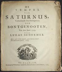
De Tempel van Saturnus Verbeeldende den Oorlogsroem der Bontgenooten van den Jaare 1709
Haarlem Netherlands: Wilhelmus van Kessel 1710. First Edition. Paperback. Good. 24 p.; 22 cm. Signatures: A-C4 4to. Woodcut title vignette of a bird feeding baby birds in a nest with a banner reading "Trouw Moet Blyken" and woodcut initial. Knuttel 15891. A very scarce poem from the War of the Spanish Succession. In Good Condition: lightly soiled and foxed primarily in the margins; lacking stitching; outer leaves are largely separated. Wilhelmus van Kessel paperback
Riferimento per il libraio : 001488
|
|
|
SCHERMERHORN W.
De positie van de Lage Landen aan de zee
39pp., 19cm.
|
|
|
Scheu, E. / Leyen, F. / Dörries, H. u.a
West- und Nordeuropa in Natur, Kultur und Wirtschaft. 34 mont. farb. Tfn., 438 Textabb. 5 Faltkarten-Beil.
Potsdam, Athenaion 1934. 4°. 596 S. lose Orig.-Lieferungen mit Orig.-Halbleder-Einbanddecke. lose Orig.-Lieferungen mit Orig.-Halbleder-Einbanddecke.
Riferimento per il libraio : 7471AB
|
|
|
SCHEU, E. u. a
West- und Nordeuropa in Natur, Kultur und Wirtschaft.
Potsdam, Athenaion, (1934). 4to. 2 Bl., 596 S. m. zahlr. Textabb., 34 farbige mont. Taf., 5 farbige Karten (Handbuch d. geograph. Wissensch.). OHldr (Rücken u. Ecken bestoßen, mehrere St.).
Riferimento per il libraio : 1113835
|
|
|
Scheuch Manfred
Atlas zur Zeitgeschichte: Bedrohte Völker (= Standard Bibliothek)
Wien (Christian Brandstätter) 1995 (= Erste Ausgabe). 4°, Originalkarton mit illustriertem Originalumschlag (Hardcover) 191 S., zahlreiche Abbildungen, ISBN 3854475586 1
Riferimento per il libraio : Khe00417
|
|
|
Scheuch, Manfred
Atlas zur Zeitgeschichte: Europa im 20. Jahrhundert. Von Manfred Scheuch. (Der Standard-Bibliothek). 2., aktualisierte und erweiterte Auflage.
Wien: Christian Brandstätter 1992. 189 Seiten. 4° (25-35 cm). Orig.-Pappband mit Orig.-Schutzumschlag. [Hardcover / fest gebunden].
Riferimento per il libraio : 107357

|
|
|
Scheuch, Manfred
Das größere Europa. Polen, Ungarn, Tschechien, Slowakei, Slowenien und die Baltischen Staaten in Geschichte und Gegenwart. Von Manfred Scheuch. (Der Standard: Bibliothek). 1. Aufl.
Wien: Brandstätter 2002. 200 Seiten. Mit 238 Abbildungen und 31 Karten. 4° (25-35 cm). Orig.-Pappband mit illustriertem Orig.-Schutzumschlag. [Hardcover / fest gebunden].
Riferimento per il libraio : 102186

|
|
|
Scheuch, Manfred (Mitwirkender)
Nackt : Kulturgeschichte eines Tabus im 20. Jahrhundert. 1. Aufl.
Wien: Brandstätter., 2004. 256 S. : überw. Ill. Pp.
Riferimento per il libraio : 1248532

|
|
|
Scheuch, Manfred (Mitwirkender)
Nackt : Kulturgeschichte eines Tabus im 20. Jahrhundert. Manfred Scheuch. 1. Aufl.
Wien : Brandstätter. 2004. 256 S. : überw. Ill. 25*17 cm. OPappband, OSchu.
Riferimento per il libraio : 156434

|
|
|

 Ricevere i risultati per e-mail
 Scaricare i risultati in PDF
 RSS feed
 Link
Link


