|
|
|
Orpen, Sir William
Stories of Old Ireland and Myself
New York: Henry Holt and Company 1925 WYSIWYG pricing--no added shipping charge for standard shipping within USA. Quarter tan cloth dark green cloth-covered boards gilt titles on front board & spine ix 94 pp 34 ff b & w plates. Cloth rubbed through to boards at corners spine somewhat soiled. Reminiscences of Orpen's childhood and youth in prewar Dublin. Orpen is known mostly as a portrait artist and for his war paintings. The plates are mostly of Orpen's own paintings & sketches. Shipping weight 2 lbs. First US Edition. . G/No dj. Illus. by the Author. 21½ X 16 cm. Henry Holt and Company Hardcover
书商的参考编号 : ETIR00002
|
|
|
Orr, Captain James
History of the Seventh Lanarkshire Rifle Volunteers Late 4th AD. Battalion and 29th L.R.V
Robert Anderson Glasgow 1884. 1st Edition . Hardcover. Good. Robert Anderson Glasgow 1884. 1st Edition . Good. Approx 9'' tall brown binding with gilt titles & emblem on the front & spine. Some wear to edges of spine & corners. Slight mark/damage to front cover see pictures. Xv 641pp. Ex reference library with number to spine & inside. Bookplate on front pastedown stamps on endpapers one stamp on first page & one with numbers on reverse of title page. No other obvious library markings: inner book is clean & in very good condition. Heavy and may require extra overseas postage <br/><br/> Robert Anderson, Glasgow hardcover
书商的参考编号 : 270
|
|
|
Orr, Elizabeth & Orr, William
Rivers of the West: a Guide to the Geology and History
Eugene: The Authors 1985. Covers faintly edge-rubbed; 334p illus maps bibliog. Size: 4to - over 9¾" - 12" tall. First Edition. Pbk. Very Good/No Jacket as issued. The Authors Paperback
书商的参考编号 : 79669 ???????? : 0960650210 9780960650217
|
|
|
Orr, Linda
JULES MICHELET: NATURE HISTORY AND LANGUAGE
Ithaca/London:: Cornell Univ. Press. VG clean HB; DJ-G/VG. 1976. ISBN: xvi 215 pp. Catalogs: HISTORY - EUROPE. Keywords: LANGUAGE. Cornell Univ. Press unknown
书商的参考编号 : BOOKS006834I
|
|
|
Orr, Richard, und Joyce Pope
Säugetiere in Europa / [aus d. Engl. übers.].
Gütersloh [u.a.] : Bertelsmann-Club [u.a.], [1986]. 176 S. : zahlr. Ill., Kt. 4°. Lizenzausg. OPpbd. mit SU. (Buch ; 30304)
书商的参考编号 : 27605
|
|
|
Orringer, Julie
Die unsichtbare Brücke : Roman / aus d. amerikan. Engl. von Andrea Fischer.
Köln : Kiepenheuer & Witsch, 2011. 820 S. 8°. 1. Aufl. Bibl.- Einbd. mit Lesebändchen.
书商的参考编号 : 39380
|
|
|
ORSIERES Jean-Martin-Félix (1803-1870)
Ecrits pédagogiques, religieux et politiques.
Edités par les soins de Lin Colliard. Aoste. 1981. Grand in-8, 390 pages. Broché.
书商的参考编号 : 58849
|
|
|
ORS EUGENIO D'
L'ARTE DI GOYA SEGUITO DA TRE ORE AL MUSEO DEL PRADO E DA UNA NUOVA VISITA AL MUSEO DEL PRADO
43 tavole in bianco e nero fuori testo
|
|
|
ORSELLO Gian Piero a cura.
L'Italia e l'Europa. Convegno nazionale dal centro italiano di studi europei Luigi Einaudi 5-7 maggio 1965. Vol. I-II.
Volumi due in-8° gr. pp. XXVII-583-615, legature edit. con sovracoperte con i risvolti erosi.. Ottima la conservazione, in cofanetto

|
|
|
ORSELLO, Gian Piero (a cura di)
L'Italia e l'Europa
2 voll. (XXXII, 583; 615 pp.); 25 cm. Legatura edit. in tela. Dorsi legg. scoloriti. A cura di Gian Piero Orsello, prefazione di Giovanni Gronchi
|
|
|
Orsini Carolina (A cura di)
Ethnopassion. Altre culture a Milano. Quattro collezioni del Castello Sforzesco dall'Africa e dalle Americhe
illustrazioni

|
|
|
Orsini, A (ed)
The European Union Within International Organisations: Commitment Consistency and Effects Across Time Globalisation Europe and Multilateralism
Ashgate 2014. This is an ex-library book and may have the usual library/used-book markings inside.This book has soft covers. In fair condition suitable as a study copy. Library sticker on front cover. Please note the Image in this listing is a stock photo and may not match the covers of the actual item500grams ISBN:9781472424150 Ashgate paperback
书商的参考编号 : 4332232 ???????? : 1472424158 9781472424150
|
|
|
Orsolina Valeri
L'Europa dopo la caduta del muro di Berlino
|
|
|
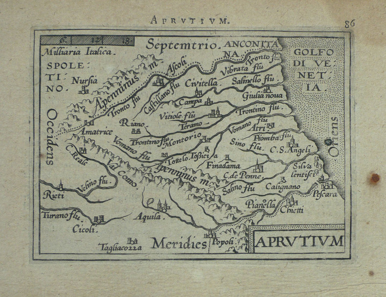
ORTELIUS (Abraham);
[ABRUZZES] Aprutium.
Anvers 1598 80 x 105 mm.
书商的参考编号 : LBW-1406
|
|
|
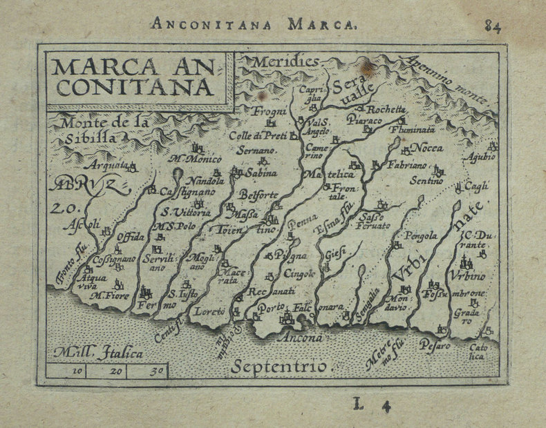
ORTELIUS (Abraham);
[ANCONE] Marca Anconitana.
Anvers 1598 82 x 106 mm.
书商的参考编号 : LBW-1407
|
|
|
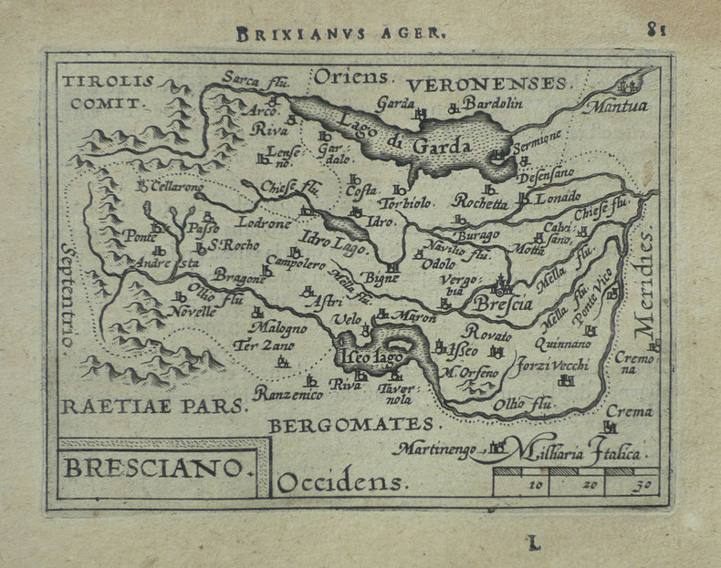
ORTELIUS (Abraham);
[BRESCIA] Bresciano.
Anvers 1598 82 x 106 mm.
书商的参考编号 : LBW-1419
|
|
|
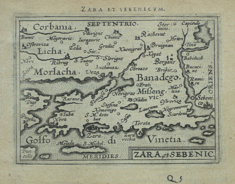
ORTELIUS (Abraham);
[CROATIE] Zara et Sebenico.
Anvers 1598 81 x 105 mm.
书商的参考编号 : LBW-1430
|
|
|
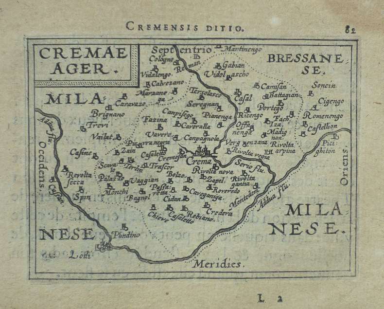
ORTELIUS (Abraham);
[CREMA] Cremae ager.
Anvers 1598 82 x 105 mm.
书商的参考编号 : LBW-1421
|
|
|
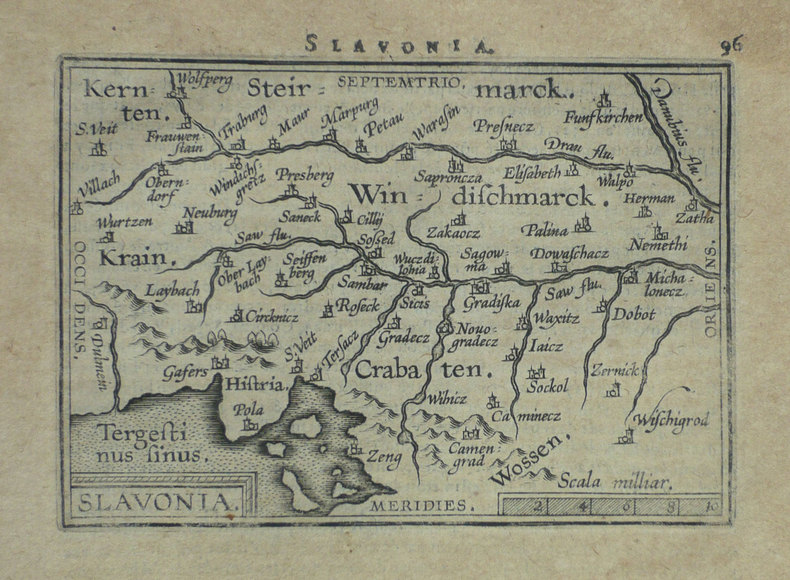
ORTELIUS (Abraham);
[CROATIE] Slavonia.
Anvers 1598 80 x 110 mm.
书商的参考编号 : LBW-1399
|
|
|
ORTELIUS (Abraham);
[CROATIE] Histria.
Anvers 1598 82 x 105 mm.
书商的参考编号 : LBW-1389

|
|
|
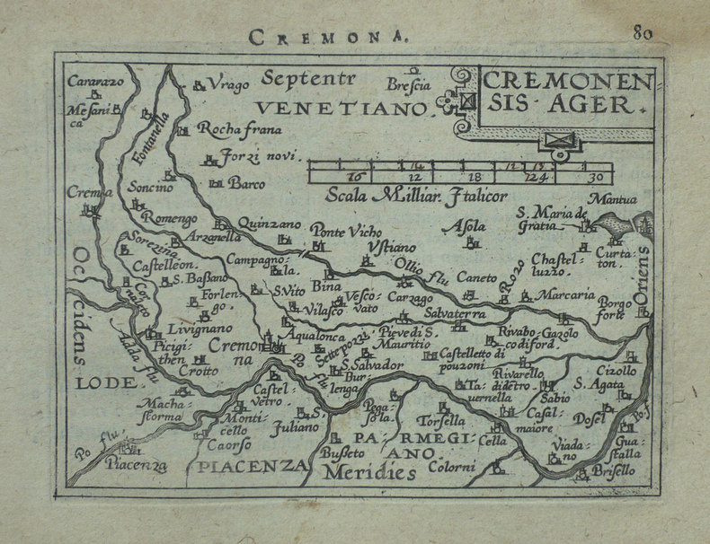
ORTELIUS (Abraham);
[CREMONE] Cremonensis ager.
Anvers 1598 80 x 105 mm.
书商的参考编号 : LBW-1418
|
|
|
ORTELIUS (Abraham);
[FLORENCE] Florentinum dominium.
Anvers 1598 81 x 105 mm.
书商的参考编号 : LBW-1410

|
|
|
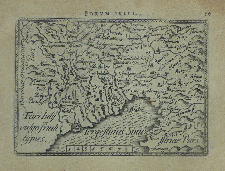
ORTELIUS (Abraham);
[FRIOUL] Fori Iuly vulgo Friuli typus.
Anvers 1598 82 x 105 mm.
书商的参考编号 : LBW-1422
|
|
|
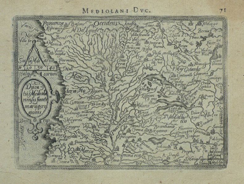
ORTELIUS (Abraham);
[MILANAIS] Ducatus Mediolanensis finitimarumq regionis.
Anvers 1598 83 x 110 mm.
书商的参考编号 : LBW-1412
|
|
|
ORTELIUS (Abraham);
[ORVIETO] Oropitum.
Anvers 1598 81 x 105 mm.
书商的参考编号 : LBW-1415

|
|
|
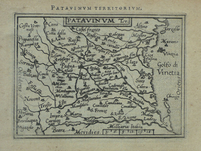
ORTELIUS (Abraham);
[PADOUE] Patavinum.
Anvers 1598 82 x 105 mm.
书商的参考编号 : LBW-1423
|
|
|
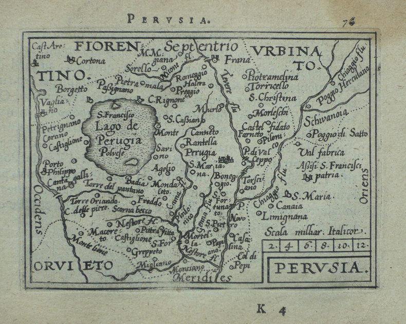
ORTELIUS (Abraham);
[PEROUSE] Perusia.
Anvers 1598 82 x 107 mm.
书商的参考编号 : LBW-1416
|
|
|
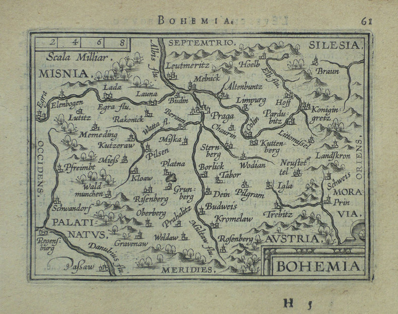
ORTELIUS (Abraham);
[REPUBLIQUE TCHEQUE] Bohemia.
Anvers 1598 81 x 105 mm.
书商的参考编号 : LBW-1401
|
|
|
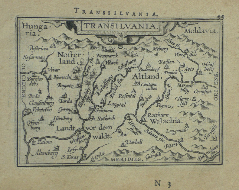
ORTELIUS (Abraham);
[ROUMANIE] Transilvania.
Anvers 1598 80 x 105 mm.
书商的参考编号 : LBW-1395
|
|
|
ORTELIUS (Abraham);
[ROME] Romanum territorium.
Anvers 1598 81 x 106 mm.
书商的参考编号 : LBW-1409

|
|
|
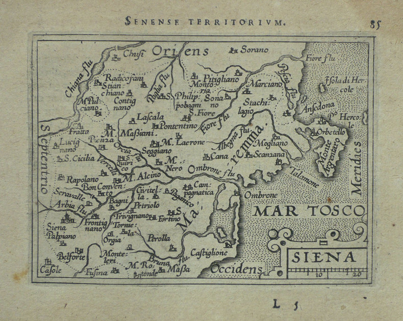
ORTELIUS (Abraham);
[SIENNE] Siena.
Anvers 1598 83 x 106 mm.
书商的参考编号 : LBW-1420
|
|
|
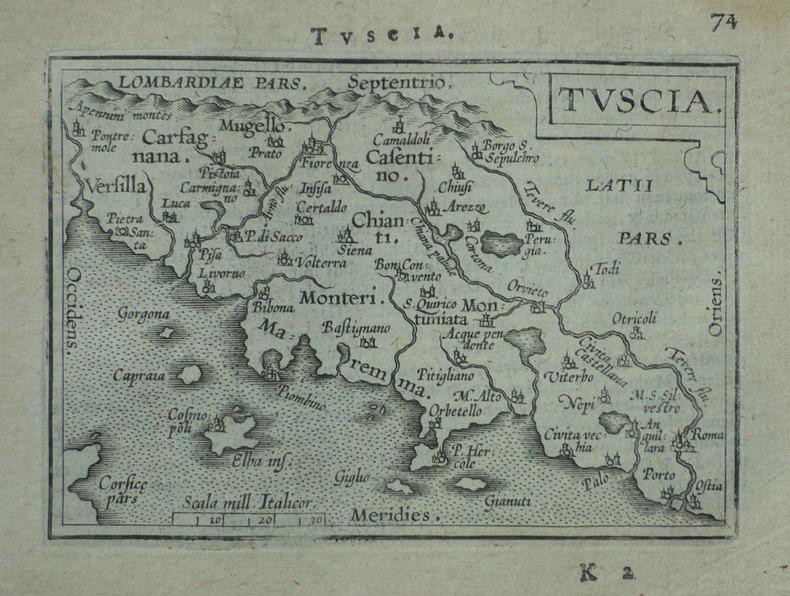
ORTELIUS (Abraham);
[TOSCANE] Tuscia.
Anvers 1598 80 x 109 mm.
书商的参考编号 : LBW-1411
|
|
|
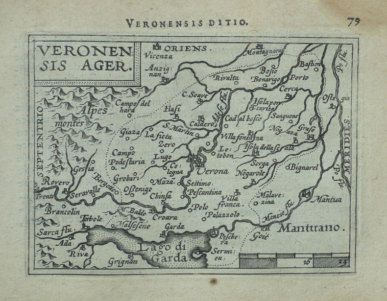
ORTELIUS (Abraham).
[VERONE] Veronensis ager.
[Anvers, 1598]. 82 x 107 mm.
书商的参考编号 : LBW-1417
|
|
|
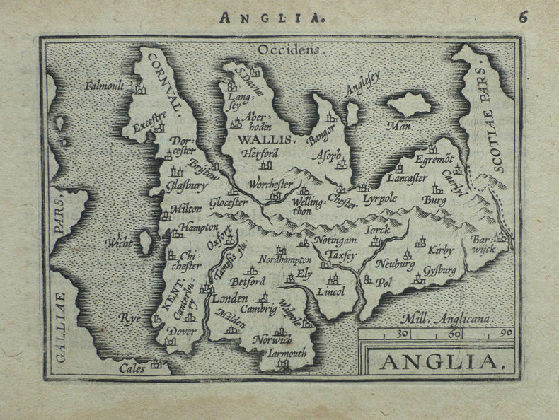
ORTELIUS (Abraham);
Anglia.
Anvers 1598 80 x 104 mm.
书商的参考编号 : LBW-1375
|
|
|
ORTIZ ECHAGÜE (José).
Espana, IV. Castillos y alcazares. Con 312 laminas en huecograbado, 14 planchas en color. Primera edicion
Madrid, Publicaciones Ortiz-Echagüé, 1956 in-4, 312 pp., texte sur deux colonnes, avec de nombreuses illustrations en noir dans le texte, et 14 planches hors texte (vignettes en couleurs contrecollées), toile cerise, couverture illustrée conservée (reliure de l'éditeur). Un mors abîmé.
书商的参考编号 : 225902
|
|
|
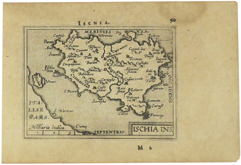
ORTELIUS (Abraham).
Ischia ins.
[Anvers, 1598]. 82 x 106 mm.
书商的参考编号 : LBW-1405
|
|
|
Ortega y Gasset, José
Die Schrecken des Jahres Eintausend : Kritik an einer Legende. [Aus dem Span. übers. von Ulrich Kunzmann. Hrsg. und mit einem Kommentar von Steffen Dietzsch] / Reclams Universal-Bibliothek ; Bd. 1448 : Philosophie, Geschichte, Kulturgeschichte
Leipzig : Reclam 1992. 1. Aufl. 112 S. ; 18 cm Taschenbuch 0
书商的参考编号 : 78250

|
|
|
ORTEGA Y GASSET, JOSÉ.
Europäische Kultur und europäische Völker.
|
|
|
ORTELIUS - GALLE (Haarlem, 1537; Anversa, 12 o 29 Marzo 1612)
Daniae Regni typus
Mappa tratta dalla seconda edizione in lingua francese de Le Miroir du Monde.Le Mirour du Monde è l’edizione in lingua francese in prosa dello Spieghel der Werelt, il primo atlante tascabile pubblicato nel 1577, in lingua olandese, da Philip Galle, con testo in rima curato da Peeter Heyns, e stampato dalla tipografia Plantin.Lo Spieghel der Werelt era una versione ridotta del Theatrum Orbis Terrarum di Ortelius.Le lastre, quasi tutte derivate dal Theatrum, furono disegnate e incise da Philip Galle. Due anni dopo, nel 1579, fu data alle stampe l’edizione in lingua francese in prosa, perché Heyns non aveva avuto il tempo necessario per la resa in versi, col titolo Le Miroir du Monde. Il successo di questa edizione francese, è provato proprio dalla seconda edizione pubblicata a soli 4 anni di distanza, nel 1583.Dal 1577 al 1598, Galle & Heyns pubblicarono ben 11 edizione, di cui l’ultima – edita nell’anno della morte di Ortelius – conteneva ben 123 mappe.Incisione in rame, in ottimo stato di conservazione. Miniature map published taken from the second French edition of Le Miroir du Monde, published by Galle & Heyns in 1583, printed by Plantin and first publsihed in 1577 under the title Spieghel der werelt.Le Miror du Monde is the French transaltion of the Duch poems Spieghel der Werelt, the first modern pocket-atlas, published by Philip Galle with text by Peeter Heyns in 1577, based on Abraham Ortelius’ Theatrum Orbis Terrarum. The maps were drawn and engraved by Galle. Between 1577 & 1598 Galle issued 11 editions, all printed by Christopher Plantin.Copperplate, very good condition. G. King, Miniature Antique Maps, pp. 60-61.

|
|
|
ORTELIUS - GALLE (Haarlem, 1537; Anversa, 12 o 29 Marzo 1612)
Ducatus Oswiczensis et Zatorieusis descriptio
Mappa tratta dalla seconda edizione in lingua francese de Le Miroir du Monde.Le Mirour du Monde è l’edizione in lingua francese in prosa dello Spieghel der Werelt, il primo atlante tascabile pubblicato nel 1577, in lingua olandese, da Philip Galle, con testo in rima curato da Peeter Heyns, e stampato dalla tipografia Plantin.Lo Spieghel der Werelt era una versione ridotta del Theatrum Orbis Terrarum di Ortelius.Le lastre, quasi tutte derivate dal Theatrum, furono disegnate e incise da Philip Galle. Due anni dopo, nel 1579, fu data alle stampe l’edizione in lingua francese in prosa, perché Heyns non aveva avuto il tempo necessario per la resa in versi, col titolo Le Miroir du Monde. Il successo di questa edizione francese, è provato proprio dalla seconda edizione pubblicata a soli 4 anni di distanza, nel 1583.Dal 1577 al 1598, Galle & Heyns pubblicarono ben 11 edizione, di cui l’ultima – edita nell’anno della morte di Ortelius – conteneva ben 123 mappe.Incisione in rame, in ottimo stato di conservazione. Miniature map published taken from the second French edition of Le Miroir du Monde, published by Galle & Heyns in 1583, printed by Plantin and first publsihed in 1577 under the title Spieghel der werelt.Le Miror du Monde is the French transaltion of the Duch poems Spieghel der Werelt, the first modern pocket-atlas, published by Philip Galle with text by Peeter Heyns in 1577, based on Abraham Ortelius’ Theatrum Orbis Terrarum. The maps were drawn and engraved by Galle. Between 1577 & 1598 Galle issued 11 editions, all printed by Christopher Plantin.Copperplate, very good condition. G. King, Miniature Antique Maps, pp. 60-61.

|
|
|
ORTELIUS - GALLE (Haarlem, 1537; Anversa, 12 o 29 Marzo 1612)
EUROPAE
Rara carta dell'Europa disegnata e incisa da Philippe Galle per la prima edizione del suo Spieghel der Werelt, tascabile, il primo atlante tascabile, edito nel 1577 in lingua olandese.La mappa, sostanzialmente basata su quella grande edita nel Theatrum Orbis Terrarum di Ortelius, rispetto alla quale è più aggiornata e ricca nella toponomastica, presenta numerosi elementi decorativi, quali navi e mostri marini. A differenza delle altre carte dell'Epitome, questas mappa ha un formato più largo. La lastra fu utilizzata solo per poche edizioni dell'opera, di qui la sua rarità.Esemplare tratto dalla seconda edizione in lingua francese de Le Miroir du Monde.Le Miroir du Monde è l’edizione in lingua francese in prosa dello Spieghel der Werelt, il primo atlante tascabile pubblicato nel 1577, in lingua olandese, da Philip Galle, con testo in rima curato da Peeter Heyns, e stampato dalla tipografia Plantin.Lo Spieghel der Werelt era una versione ridotta del Theatrum Orbis Terrarum di Ortelius.Le lastre, quasi tutte derivate dal Theatrum, furono disegnate e incise da Philip Galle. Due anni dopo, nel 1579, fu data alle stampe l’edizione in lingua francese in prosa, perché Heyns non aveva avuto il tempo necessario per la resa in versi, col titolo Le Miroir du Monde. Il successo di questa edizione francese, è provato proprio dalla seconda edizione pubblicata a soli 4 anni di distanza, nel 1583.Complessivamente Galle pubblicò 5 edizioni in lingua francese, di cui solo le prime due con il titolo Le Miroir du Monde; a partire dal 1588, e così per le edizioni del 1590 e del 1598, il titolo dell’opera fu modificato in Epitome du thétre du Monde d’Abraham Ortelius, e il nome di Peeter Heyns non figurò più sul frontespizio. Rispetto alla prima edizione del 1579, che conteneva 72 mappe, la seconda edizione fu aumentata di 11 nuove mappe, per un totale di 83 tavole.Dal 1577 al 1598, Galle & Heyns pubblicarono ben 11 edizione, di cui l’ultima – edita nell’anno della morte di Ortelius – conteneva ben 123 mappe. A fine example of that uncommon map of all Europe, designed and engraved by Philippe Galle for the first edition of Spieghel der Werelt, the first modern pocket-atlas, based on Abraham Ortelius' Theatrum Orbis Terrarum, published in 1577.This map appeared in only a handful of editions of the miniature atlas, consequently is quite rare. Europe map published by Galle is larger that the other maps in the atlas. Numerous decorative features including ships, sea-monsters and so on can be seen in elaborate design. This example was published in the second French edition of ‘Le Miroir du Monde’, published by Galle & Heyns in 1583, printed by Plantin.Le Miror du Monde is the French transaltion of the Duch poems Spieghel der Werelt, the first modern pocket-atlas, published by Philip Galle with text by Peeter Heyns in 1577, based on Abraham Ortelius’ Theatrum Orbis Terrarum. The maps were drawn and engraved by Galle. Two years later, in 1579, Galle & Heyns published the first French edition: Heyns translated the Dutch poems into French prose because he did not find time to put them into rhyme. This French edition became very popular and in 1583 an amplified reprint appeared.Galle & Heyns published 5 French edition, two with the title Miroir, and three (1588, 1590, 1598) with the title Epitome du thétre du Monde d’Abraham Ortelius, that appeared from 1588 onwards (Peeter Heyns’ name no longer figures on the title pages of the Antwerp editions).Second French edition of this rare miniature atlas, "enlarged with eleven maps... six are double sized" (Koeman p. 275).Compared to the first edition of 1579, which contained 72 maps, the second edition was increased by 11 new maps, for a total of 83 plates.Between 1577 & 1598 Galle issued 11 editions, all printed by Christopher Plantin.

|
|
|
ORTELIUS - GALLE (Haarlem, 1537; Anversa, 12 o 29 Marzo 1612)
Hungariae desciptio Wolfango Lasio descr(iptio)
Mappa tratta dalla seconda edizione in lingua francese de Le Miroir du Monde.Le Mirour du Monde è l’edizione in lingua francese in prosa dello Spieghel der Werelt, il primo atlante tascabile pubblicato nel 1577, in lingua olandese, da Philip Galle, con testo in rima curato da Peeter Heyns, e stampato dalla tipografia Plantin.Lo Spieghel der Werelt era una versione ridotta del Theatrum Orbis Terrarum di Ortelius.Le lastre, quasi tutte derivate dal Theatrum, furono disegnate e incise da Philip Galle. Due anni dopo, nel 1579, fu data alle stampe l’edizione in lingua francese in prosa, perché Heyns non aveva avuto il tempo necessario per la resa in versi, col titolo Le Miroir du Monde. Il successo di questa edizione francese, è provato proprio dalla seconda edizione pubblicata a soli 4 anni di distanza, nel 1583.Dal 1577 al 1598, Galle & Heyns pubblicarono ben 11 edizione, di cui l’ultima – edita nell’anno della morte di Ortelius – conteneva ben 123 mappe.Incisione in rame, in ottimo stato di conservazione. Miniature map published taken from the second French edition of Le Miroir du Monde, published by Galle & Heyns in 1583, printed by Plantin and first publsihed in 1577 under the title Spieghel der werelt.Le Miror du Monde is the French transaltion of the Duch poems Spieghel der Werelt, the first modern pocket-atlas, published by Philip Galle with text by Peeter Heyns in 1577, based on Abraham Ortelius’ Theatrum Orbis Terrarum. The maps were drawn and engraved by Galle. Between 1577 & 1598 Galle issued 11 editions, all printed by Christopher Plantin.Copperplate, very good condition. G. King, Miniature Antique Maps, pp. 60-61.

|
|
|
ORTELIUS - GALLE (Haarlem, 1537; Anversa, 12 o 29 Marzo 1612)
Regni Bohemiae descrptio
Mappa tratta dalla seconda edizione in lingua francese de Le Miroir du Monde.Le Mirour du Monde è l’edizione in lingua francese in prosa dello Spieghel der Werelt, il primo atlante tascabile pubblicato nel 1577, in lingua olandese, da Philip Galle, con testo in rima curato da Peeter Heyns, e stampato dalla tipografia Plantin.Lo Spieghel der Werelt era una versione ridotta del Theatrum Orbis Terrarum di Ortelius.Le lastre, quasi tutte derivate dal Theatrum, furono disegnate e incise da Philip Galle. Due anni dopo, nel 1579, fu data alle stampe l’edizione in lingua francese in prosa, perché Heyns non aveva avuto il tempo necessario per la resa in versi, col titolo Le Miroir du Monde. Il successo di questa edizione francese, è provato proprio dalla seconda edizione pubblicata a soli 4 anni di distanza, nel 1583.Dal 1577 al 1598, Galle & Heyns pubblicarono ben 11 edizione, di cui l’ultima – edita nell’anno della morte di Ortelius – conteneva ben 123 mappe.Incisione in rame, in ottimo stato di conservazione. Miniature map published taken from the second French edition of Le Miroir du Monde, published by Galle & Heyns in 1583, printed by Plantin and first publsihed in 1577 under the title Spieghel der werelt.Le Miror du Monde is the French transaltion of the Duch poems Spieghel der Werelt, the first modern pocket-atlas, published by Philip Galle with text by Peeter Heyns in 1577, based on Abraham Ortelius’ Theatrum Orbis Terrarum. The maps were drawn and engraved by Galle. Between 1577 & 1598 Galle issued 11 editions, all printed by Christopher Plantin.Copperplate, very good condition. G. King, Miniature Antique Maps, pp. 60-61.

|
|
|
ORTELIUS - GALLE (Haarlem, 1537; Anversa, 12 o 29 Marzo 1612)
Russiae moscovia et tartariae descriptio
Mappa tratta dalla seconda edizione in lingua francese de Le Miroir du Monde.Le Mirour du Monde è l’edizione in lingua francese in prosa dello Spieghel der Werelt, il primo atlante tascabile pubblicato nel 1577, in lingua olandese, da Philip Galle, con testo in rima curato da Peeter Heyns, e stampato dalla tipografia Plantin.Lo Spieghel der Werelt era una versione ridotta del Theatrum Orbis Terrarum di Ortelius.Le lastre, quasi tutte derivate dal Theatrum, furono disegnate e incise da Philip Galle. Due anni dopo, nel 1579, fu data alle stampe l’edizione in lingua francese in prosa, perché Heyns non aveva avuto il tempo necessario per la resa in versi, col titolo Le Miroir du Monde. Il successo di questa edizione francese, è provato proprio dalla seconda edizione pubblicata a soli 4 anni di distanza, nel 1583.Dal 1577 al 1598, Galle & Heyns pubblicarono ben 11 edizione, di cui l’ultima – edita nell’anno della morte di Ortelius – conteneva ben 123 mappe.Incisione in rame, in ottimo stato di conservazione. Miniature map published taken from the second French edition of Le Miroir du Monde, published by Galle & Heyns in 1583, printed by Plantin and first publsihed in 1577 under the title Spieghel der werelt.Le Miror du Monde is the French transaltion of the Duch poems Spieghel der Werelt, the first modern pocket-atlas, published by Philip Galle with text by Peeter Heyns in 1577, based on Abraham Ortelius’ Theatrum Orbis Terrarum. The maps were drawn and engraved by Galle. Between 1577 & 1598 Galle issued 11 editions, all printed by Christopher Plantin.Copperplate, very good condition. G. King, Miniature Antique Maps, pp. 60-61; Koeman 331:12; Phillips 387

|
|
|
ORTELIUS - GALLE (Haarlem, 1537; Anversa, 12 o 29 Marzo 1612)
Scotiae descriptio
Mappa tratta dalla seconda edizione in lingua francese de Le Miroir du Monde.Le Mirour du Monde è l’edizione in lingua francese in prosa dello Spieghel der Werelt, il primo atlante tascabile pubblicato nel 1577, in lingua olandese, da Philip Galle, con testo in rima curato da Peeter Heyns, e stampato dalla tipografia Plantin.Lo Spieghel der Werelt era una versione ridotta del Theatrum Orbis Terrarum di Ortelius.Le lastre, quasi tutte derivate dal Theatrum, furono disegnate e incise da Philip Galle. Due anni dopo, nel 1579, fu data alle stampe l’edizione in lingua francese in prosa, perché Heyns non aveva avuto il tempo necessario per la resa in versi, col titolo Le Miroir du Monde. Il successo di questa edizione francese, è provato proprio dalla seconda edizione pubblicata a soli 4 anni di distanza, nel 1583.Dal 1577 al 1598, Galle & Heyns pubblicarono ben 11 edizione, di cui l’ultima – edita nell’anno della morte di Ortelius – conteneva ben 123 mappe.Incisione in rame, in ottimo stato di conservazione. Miniature map published taken from the second French edition of Le Miroir du Monde, published by Galle & Heyns in 1583, printed by Plantin and first publsihed in 1577 under the title Spieghel der werelt.Le Miror du Monde is the French transaltion of the Duch poems Spieghel der Werelt, the first modern pocket-atlas, published by Philip Galle with text by Peeter Heyns in 1577, based on Abraham Ortelius’ Theatrum Orbis Terrarum. The maps were drawn and engraved by Galle. Between 1577 & 1598 Galle issued 11 editions, all printed by Christopher Plantin.Copperplate, very good condition. G. King, Miniature Antique Maps, pp. 60-61.

|
|
|
ORTELIUS - GALLE (Haarlem, 1537; Anversa, 12 o 29 Marzo 1612)
Silesiae typus descriptue et editus a Martino heilvig Neisense et nobili viro niolao Rhedinger dedicat
Mappa tratta dalla seconda edizione in lingua francese de Le Miroir du Monde.Le Mirour du Monde è l’edizione in lingua francese in prosa dello Spieghel der Werelt, il primo atlante tascabile pubblicato nel 1577, in lingua olandese, da Philip Galle, con testo in rima curato da Peeter Heyns, e stampato dalla tipografia Plantin.Lo Spieghel der Werelt era una versione ridotta del Theatrum Orbis Terrarum di Ortelius.Le lastre, quasi tutte derivate dal Theatrum, furono disegnate e incise da Philip Galle. Due anni dopo, nel 1579, fu data alle stampe l’edizione in lingua francese in prosa, perché Heyns non aveva avuto il tempo necessario per la resa in versi, col titolo Le Miroir du Monde. Il successo di questa edizione francese, è provato proprio dalla seconda edizione pubblicata a soli 4 anni di distanza, nel 1583.Dal 1577 al 1598, Galle & Heyns pubblicarono ben 11 edizione, di cui l’ultima – edita nell’anno della morte di Ortelius – conteneva ben 123 mappe.Incisione in rame, in ottimo stato di conservazione. Miniature map published taken from the second French edition of Le Miroir du Monde, published by Galle & Heyns in 1583, printed by Plantin and first publsihed in 1577 under the title Spieghel der werelt.Le Miror du Monde is the French transaltion of the Duch poems Spieghel der Werelt, the first modern pocket-atlas, published by Philip Galle with text by Peeter Heyns in 1577, based on Abraham Ortelius’ Theatrum Orbis Terrarum. The maps were drawn and engraved by Galle. Between 1577 & 1598 Galle issued 11 editions, all printed by Christopher Plantin.Copperplate, very good condition. G. King, Miniature Antique Maps, pp. 60-61.

|
|
|
ORTELIUS - GALLE (Haarlem, 1537; Anversa, 12 o 29 Marzo 1612)
Transilvania
Mappa tratta dalla seconda edizione in lingua francese de Le Miroir du Monde.Le Mirour du Monde è l’edizione in lingua francese in prosa dello Spieghel der Werelt, il primo atlante tascabile pubblicato nel 1577, in lingua olandese, da Philip Galle, con testo in rima curato da Peeter Heyns, e stampato dalla tipografia Plantin.Lo Spieghel der Werelt era una versione ridotta del Theatrum Orbis Terrarum di Ortelius.Le lastre, quasi tutte derivate dal Theatrum, furono disegnate e incise da Philip Galle. Due anni dopo, nel 1579, fu data alle stampe l’edizione in lingua francese in prosa, perché Heyns non aveva avuto il tempo necessario per la resa in versi, col titolo Le Miroir du Monde. Il successo di questa edizione francese, è provato proprio dalla seconda edizione pubblicata a soli 4 anni di distanza, nel 1583.Dal 1577 al 1598, Galle & Heyns pubblicarono ben 11 edizione, di cui l’ultima – edita nell’anno della morte di Ortelius – conteneva ben 123 mappe.Incisione in rame, in ottimo stato di conservazione. Miniature map published taken from the second French edition of Le Miroir du Monde, published by Galle & Heyns in 1583, printed by Plantin and first publsihed in 1577 under the title Spieghel der werelt.Le Miror du Monde is the French transaltion of the Duch poems Spieghel der Werelt, the first modern pocket-atlas, published by Philip Galle with text by Peeter Heyns in 1577, based on Abraham Ortelius’ Theatrum Orbis Terrarum. The maps were drawn and engraved by Galle. Between 1577 & 1598 Galle issued 11 editions, all printed by Christopher Plantin.Copperplate, very good condition. G. King, Miniature Antique Maps, pp. 60-61.

|
|
|
ORTELIUS Abraham (1528 - 1598)
Angliae, Scotiae, Et Hiberniae Sive Britannicae Insularum Descriptio
Carta geografica delle Isole Britanniche tratta dall'edizione italiana del Theatrum Orbis Therrarum di Ortelius, 1606.Terzo stato della lastra di questa importante mappa basata sulla carta murale di Mercator del 1564. Il Theatrum Orbis Terrarum è considerato il primo vero “atlante” moderno. L’opera fu pubblicata in 7 lingue e 36 edizioni, per il quale – nel 1570 - Ortelius ottenne il privilegio, ovvero una sorta di diritto d'autore che impediva ad altri cartografi di pubblicare i propri lavori. Il Theatrum rappresentava il lavoro più avanzato del lavoro della descrizione cartografica. L’Ortelius vi raccolse il sapere geografico e cartografico del suo tempo, proponendo in 147 spettacolari tavole incise l’immagine più fedele del mondo allora conosciuto e, in alcune straordinarie “carte storiche”, regioni e itinerari tratti dalla letteratura, dalla mitologia, dalla tradizione. Ortelius fu anche il primo a citare le fonti, menzionando i nomi dei cartografi nel “catalogus auctorum”. Dal 1598 al 1612 le edizioni postume del Theatrum furono realizzate dal suo collaboratore Johannes Baptiste Vrients. Incisione in rame, eccellente coloritura coeva, in ottimo stato di conservazione. Attractive full color example of Ortelius' first map of the British Isles, from Ortelius' Theatrum Orbis Terrarum, the first modern atlas of the world.A state 3 of this classic, handsome and decorative map of ancient British Isles with north orientated to the east. Italian text on verso. From the Vrients edition of 1606.Based on Mercator's 1564 map of the British isles and improved by Saxton's 1579 map and the writings of the ancient classical writers. Embellishments include seven ships and three decorative strap work cartouches. Map taken from the Theatrum Orbis Terrarum, which is considered the first true modern "Atlas". The work was published in 7 languages and 36 editions, for which - in 1570 - Ortelius obtained the privilege, a kind of copyright that prevented other cartographers from publishing his works. The Theatrum represented the most advanced work of cartographic description. Ortelius collected in it the geographical and cartographic knowledge of his time, proposing in 147 spectacular engraved plates the most faithful image of the world then known and, in some extraordinary "historical maps", regions and routes taken from literature, mythology, tradition. Ortelius was also the first to cite sources, mentioning the names of cartographers in the "catalogus auctorum". From 1598 to 1612 the posthumous editions of the Theatrum were made by his collaborator Johannes Baptiste Vrients. Copper engraving, contemporary coloring, in good condition. Broecke, Ortelius 16, state 3. Shirley (1991), map 82, plate 42.

|
|
|
ORTELIUS Abraham (1528 - 1598)
Britannicarum Insularum Typus
Decorativa carta geografica delle Isole Britanniche, riferita al tempo degli antichi Romani.La carta, per la prima volta pubblicata da Ortelius nel suo Parergon del 1595, è basta su informazioni geografiche fornite dalla carta murale delle Isole Britanniche di Mercator (1564) e sugli aggiornamenti forniti da Saxton (1579). Le notizie storiche sono invece derivanti dalle fonti classiche quali Plinio, Tacito, Appiano e Strabone. Tratta dal Parergon, il primo atlante storico mai pubblicato. Fu inizialmente concepito da Ortelius come appendice del suo Theatrum Orbis Terrarum ma visto il notevole successo di queste carte storiche divenne in seguito un lavoro indipendente e rimase la fonte principale di tutti i lavori simili per tutto il XVII secolo. Come sottolinea Koeman “il Parergon deve essere considerato come lavoro personale di Ortelius. Per quest'opera, infatti, diversamente dal Theatrum, non copiò le mappe di altri cartografi, ma ne disegnò lui stesso di nuove ed originali…prese luoghi, regioni e territori delle civiltà classiche illustrandone e spiegandone la storia, una materia molto vicina al suo cuore. Le mappe e le lastre del Parergon devono essere valutate come le più importanti incisioni che rappresentano il diffuso interesse per la geografia classica nel XVI secolo”. Il Theatrum Orbis Terrarum e che è considerato il primo vero “atlante” moderno. L’opera fu pubblicata in 7 lingue e 36 edizioni, per il quale – nel 1570 - Ortelius ottenne il privilegio, ovvero una sorta di diritto d'autore che impediva ad altri cartografi di pubblicare i propri lavori. Il Theatrum rappresentava il lavoro più avanzato del lavoro della descrizione cartografica. L’Ortelius vi raccolse il sapere geografico e cartografico del suo tempo, proponendo in 147 spettacolari tavole incise l’immagine più fedele del mondo allora conosciuto e, in alcune straordinarie “carte storiche”, regioni e itinerari tratti dalla letteratura, dalla mitologia, dalla tradizione. Esemplare tratto dall'edizione latina del 1619. Incisione in rame, finemente colorata a mano, in ottimo stato di conservazione. Decorative and rare map of the British Isles in Roman times. The map was first published in the 1595 edition of Ortelius' atlas. The map was made based upon modern information from Mercator's 1564 map of the British Isles, improved by a new outline from Saxton's 1579 map (Meurer p. 197, Karrow 56/16, p. 387-388)nd ancient knowledge from Diodorus, Siculus, Plinius, Appianus, Tacitus, Cæsar and Strabo. The map is filled with ancient place names, Hadrian's Wall, and Wall of Pius (mislabeled Severi Imp. Murus).Richly embellished with three large strapwork cartouches and several sailing vessels. Map taken from the Parergon, the first historical atlas ever published. It was initially conceived by Ortelius as an appendix to his Theatrum Orbis Terrarum, but given the considerable success of these historical maps it later became an independent work and remained the main source of all similar works throughout the seventeenth century. Koeman wrote: "This atlas of ancient geography must be regarded as a personal work of Ortelius. For this work he did not, as in the Theatrum, copy other people's maps but drew the originals himself... He took many places and regions from the lands of classical civilization to illustrate and clarify their history, a subject very close to his heart... The maps and plates of the Parergon have to be evaluated as the most outstanding engravings depicting the wide-spread interest in classical geography in the 16th century." The Theatrum Orbis Terrarum, which is considered the first true modern "Atlas". The work was published in 7 languages and 36 editions, for which - in 1570 - Ortelius obtained the privilege, a kind of copyright that prevented other cartographers from publishing his works. The Theatrum represented the most advanced work of cartographic description. Ortelius collected in it the geographical and cartographic knowledge of his time, proposing in 147 spectacular engraved plates the most faithful image of the world then known and, in some extraordinary "historical maps", regions and routes taken from literature, mythology, tradition. Latin editon of 1619. Copperplate with fine hand colouring, very good condition. Van den Broecke #192; Shirley, R.W. (BI to 1650) 186, pl.42.

|
|
|
ORTELIUS Abraham (1528 - 1598)
Carinthiae Dvcatvs, et Goritiae Palatinatvs, Wolf. Lazio
Tre carte in un foglio tratto dal Theatrum Orbis Terrarum di Ortelius, raffiguranti la Carinzia, L'Istria e il Ducato di Zara. Le mappe derivano da Wolfgang Latius e Pietro Coppo. Il Theatrum Orbis Terrarum è considerato il primo vero “atlante” moderno. L’opera fu pubblicata in 7 lingue e 36 edizioni, per il quale – nel 1570 - Ortelius ottenne il privilegio, ovvero una sorta di diritto d'autore che impediva ad altri cartografi di pubblicare i propri lavori. Il Theatrum rappresentava il lavoro più avanzato del lavoro della descrizione cartografica. L’Ortelius vi raccolse il sapere geografico e cartografico del suo tempo, proponendo in 147 spettacolari tavole incise l’immagine più fedele del mondo allora conosciuto e, in alcune straordinarie “carte storiche”, regioni e itinerari tratti dalla letteratura, dalla mitologia, dalla tradizione. Ortelius fu anche il primo a citare le fonti, menzionando i nomi dei cartografi nel “catalogus auctorum”. Dal 1598 al 1612 le edizioni postume del Theatrum furono realizzate dal suo collaboratore Johannes Baptiste Vrients. Incisione in rame, eccellente coloritura, in ottimo stato di conservazione. Nice set of three maps on a single sheet, including the region around Villach on the Dravus River, the Gulf of Trieste and Quernero and the region around Zara and Sebenico. Very detailed regional maps, one of which even shows bridges across the river. A gorgeous full color example, with wide margins. After Wolfgang Latius & Pietro Coppo. Map taken from the Theatrum Orbis Terrarum, which is considered the first true modern "Atlas". The work was published in 7 languages and 36 editions, for which - in 1570 - Ortelius obtained the privilege, a kind of copyright that prevented other cartographers from publishing his works. The Theatrum represented the most advanced work of cartographic description. Ortelius collected in it the geographical and cartographic knowledge of his time, proposing in 147 spectacular engraved plates the most faithful image of the world then known and, in some extraordinary "historical maps", regions and routes taken from literature, mythology, tradition. Ortelius was also the first to cite sources, mentioning the names of cartographers in the "catalogus auctorum". From 1598 to 1612 the posthumous editions of the Theatrum were made by his collaborator Johannes Baptiste Vrients. Copper engraving, fine coloring, in good condition. M. Van den Broecke "Ortelius Atlas Maps" (2011), n. 143.

|
|
|
 ?????????
 ?????PDF???
 RSS feed


