|
|
|
ROUGE Georg Louis le (1721-1790 circa)
Le Royaume de Hongrie
Carta geografica tratta dal raro "Introduction a la Geographie" di G. Louis Le Rouge, pubblicato a Parigi tra il 1747 ed il 1756, a "Paris, chez l'Auteur, Prault le fils, la Veuve Robinot, 1756".L'opera, che l'autore definisce come "Atlas Nouveau Portatif à l'Uage des Militaires et du Voyageur', contiene 86 carte geografiche.Incisione in rame, coloritura coeva dei contorni, in ottimo stato di conservazione. Map taken from the "Introduction a la Geographie" published from 1747 and 1756, printed in "Paris, chez l'Auteur, Prault le fils, la Veuve Robinot, 1756".The work, which the author defines as "Atlas Nouveau Portatif à l'Usage des Militaires et du Voyageur", contains 86 maps.Copperplate with original outline colour, very good conditions.

|
|
|
ROUGE Georg Louis le (1721-1790 circa)
Le XVII Provinces des Pays Bas
Carta geografica tratta dal raro "Introduction a la Geographie" di G. Louis Le Rouge, pubblicato a Parigi tra il 1747 ed il 1756, a "Paris, chez l'Auteur, Prault le fils, la Veuve Robinot, 1756".L'opera, che l'autore definisce come "Atlas Nouveau Portatif à l'Uage des Militaires et du Voyageur', contiene 86 carte geografiche.Incisione in rame, coloritura coeva dei contorni, in ottimo stato di conservazione. Map taken from the "Introduction a la Geographie" published from 1747 and 1756, printed in "Paris, chez l'Auteur, Prault le fils, la Veuve Robinot, 1756".The work, which the author defines as "Atlas Nouveau Portatif à l'Usage des Militaires et du Voyageur", contains 86 maps.Copperplate with original outline colour, very good conditions.

|
|
|
ROUGE Georg Louis le (1721-1790 circa)
Royaume de Danemarck
Carta geografica tratta dal raro "Introduction a la Geographie" di G. Louis Le Rouge, pubblicato a Parigi tra il 1747 ed il 1756, a "Paris, chez l'Auteur, Prault le fils, la Veuve Robinot, 1756".L'opera, che l'autore definisce come "Atlas Nouveau Portatif à l'Uage des Militaires et du Voyageur', contiene 86 carte geografiche.Incisione in rame, coloritura coeva dei contorni, in ottimo stato di conservazione. Map taken from the "Introduction a la Geographie" published from 1747 and 1756, printed in "Paris, chez l'Auteur, Prault le fils, la Veuve Robinot, 1756".The work, which the author defines as "Atlas Nouveau Portatif à l'Usage des Militaires et du Voyageur", contains 86 maps.Copperplate with original outline colour, very good conditions.

|
|
|
ROUGE Georg Louis le (1721-1790 circa)
Theatre de la Guerre entre les Russes, Les Turcs, et Les Polonois. Tire du Cabinet de M. le Marquis de Paulmy Ministre d'Eta
Rara mappa che illustra il Teatro della guerra russo-turca (1768-1774).La mappa si focalizza sui territori situati sulle coste settentrionali e occidentali del Mar d’Azov e del Mar Nero e della Crimea, ovvero Bulgaria, Romania, Moldavia, Ucraina (allora parte della Polonia) e Russia, che si estendono fino ad Astracan e al Mar Caspio.La mappa è tratta da carte manoscritte realizzate a partire dall'ultima guerra russo-turca che si è svolta tra il 1735 e il 1739. In alto a destra si trova il resoconto dettagliato della guerra precedente, con l’indicazione delle date importanti, delle battaglie e di altri fattori che hanno portato all’attuale situazione politica descritta dalla mappa. La carta illustra le nuove città e i forti costruiti dai russi, lungo il Dnieper e il Don, e nelle città di Orel e Samara.Acquaforte con coloritura coeva dei contorni, più volte ripiegata, in buono stato di conservazione. Fine example of this rare map illustrating the Theater of Russo-Turkish War (1768-1774).The map emphasizes the territories located on the north and west coasts of the Sea of Azov and the Black Sea and Crimea, namely Bulgaria, Romania, Moldova, Ukraine (then part of Poland) and Russia, extending to Astracan and the Caspian Sea.The map is drawn from handwritten maps drawn up since the last Russian-Turkish war which took place between 1735 and 1739, most notably New Servia, territory bordering the new Russian-Turkish border in Ukraine, which was won by the Russians during this war. At the top right is detailed accounting of the prior war, setting for the important dates, battles and other factors leading to the current map.The map illustrates the new cities and forts built by the Russians, along the Dnieper and the Don, and in the cities of Orel and Samara. Copperplate with original outline colour, usual folds, good condition.

|
|
|
Rouge, Le Petit Homme
The Favourites of Henry of Navarre
Boston: Gorham Press. Very Good with no dust jacket; Boards rubbed and dampstained at spine. 1910. First American Edition. Hardcover. Blue cloth binding with gilt heraldic design on front boards. Top edges gilt. Gilt lettering on spine. Six illustrations. Index appendices. The author contends that 16th century French King Henri IV also known as Henry of Navarre was profoundly influenced by the various women in his life. ; 8vo 8" - 9" tall; 320 pages . Gorham Press hardcover
Référence libraire : 26248

|
|
|
Rougemont D. and Braley A.trans
The Meaning of Europe
Sidgwick & Jackson 1963. This is an ex-library book and may have the usual library/used-book markings inside.This book has hardback covers. Book contains pencil markings In poor condition suitable as a reading copy. No dust jacket. Re-bound by library. Please note the Image in this listing is a stock photo and may not match the covers of the actual item300grams ISBN: Sidgwick & Jackson hardcover
Référence libraire : 9702640
|
|
|
ROUGEMONT (Denis de)
Fédéralisme culturel suivi des allocutions prononcées lors des cérémonies du 25è anniversaire de l'Institut neuchâtelois.
Conférence donnée par Denis de ROUGEMONT à l'Aula de l'Université de Neuchâtel à l'occasion du 25è anniversaire de l'Institut neuchâtelois sur diversités culturelles et culture européenne ("à l'image des "racines", j'oppose celle de l'implantation, qui est une action délibérée de l'homme"); suivie d'allocutions de Jacques CORNU et de Louis de MONTMOLLIN; liste des membres de l'Institut de 1938 à 1965. Français

|
|
|
ROUGEMONT (Denis de)
Inédits. Extraits de cours choisis et présentés par Jean Mantzouranis et François Saint-Ouen.
In-8, 246p. Préface d'Alexandre Marc. Importante bibliographie des écrits de Denis de Rougemont en fin de volume. A l'état de neuf.
|
|
|
ROUGEMONT (Denis de)
L'Europe en jeu. Trois discours, suivis de Documents de La Haye.
In-8, 170p. A l'état de neuf, non coupé, bande de lancement conservée.
|
|
|
Rougemont, Dd. (Ed.) D. d.
State of the Union of Europe: Report of the CADMOS Group to the European People
Pergamon Press 1979. This is an ex-library book and may have the usual library/used-book markings inside.This book has soft covers. In good all round condition. Please note the Image in this listing is a stock photo and may not match the covers of the actual item200grams ISBN:0080244769 Pergamon Press paperback
Référence libraire : 7718575 ISBN : 0080244769 9780080244761
|
|
|
Rougemont, Denis de
The idea of Europe
Cleveland Ohio: Meridian Books The World Publishing Company 1968. Softcover. Good. 8vo 8" - 9" tall. A perfectly serviceable reference copy; nothing fancy but complete and sturdy. Translated from the original French by Norbert Guterman. Furled fore-edges to front cover a bit soiled and sunned along edges but with clean unmarked interior. Volume contains scholarly apparatus in the form of e.g. notes index and bibliography. xii 1 3-434 pp.Member I.O.B.A. C.B.A. and adherent to the highest ethical standards. Additional postage may be required for oversize or especially heavy volumes and for sets. Meridian Books, The World Publishing Company paperback
Référence libraire : 356794

|
|
|
ROUGEMONT, Denis de
Europa. Vom Mythos zur Wirklichkeit.
München, Prestel, 1962. 419 S. OLwd (mit OUmschlag).
Référence libraire : 3166298
|
|
|
Rouir, Eugène
Europäische Graphik im 17. [siebzehnten] Jahrhundert. [Aus d. Franz. übertr. von Peter Kamnitzer]
Köln : Edition von Nottbeck im Verl. Wiss. u. Politik, [1975]. 252 S. : zahlr. Ill. ; 21 cm Lw.
Référence libraire : 21187
|
|
|
Rouir, Eugène
Europäische Graphik im 17. Jahrhundert
Köln: Edition von Nottbeck im Verlag Wissenschaft und Politik, 1975. 21 cm ; Leinen
Référence libraire : 94913

|
|
|
Roulet, Louis-Edouard.
L`Établissement de la mairie de la Chaux-de-Fonds en 1656.
301 pp., 2 facsimiles, 1 plan, 2 portraits. Orig. cardboards with dust jacket. Bücher de
|
|
|
Roulland Leon
LA FOIRE SAINT-GERMAIN SOUS LES REGNES DE CHARLES IX DE HENRI III ET DE HENRI IV
Paris: Societe de l'historire 1877. HC. very good blue leather spine marbled boards hardcover. History of the early fair at Saint-Germain. 31pp. Societe de l'historire unknown
Référence libraire : BOOKS062720I
|
|
|
Roulstone, A. and Roulstone, M.
Fenland Waterways
Balfour Publications 1974. This is an ex-library book and may have the usual library/used-book markings inside.This book has hardback covers. In good all round condition. Dust jacket in fair condition. Please note the Image in this listing is a stock photo and may not match the covers of the actual item500grams ISBN:0859440214 Balfour Publications hardcover
Référence libraire : 8545268 ISBN : 0859440214 9780859440219

|
|
|
Round, Jeffrey I. (editor)
The European Economy in Perspective
Near Fine in a VG+ dust jacket. 348 pp.
|
|
|
Round, Jeffrey I. (editor)
The European Economy in Perspective
Near Fine in a VG+ dust jacket. 348 pp.
|
|
|
Rouquerol, Gabriel.
L'Artillerie dans la bataille du 18 août. Essai critique. Considérations sur l'artillerie de campagne à tir rapide. Avec 7 croquis panoramiques et 7 plans avec 18 transparents.
Paris Nancy Berger-Levrault 1906. 1st Edition . Hardcover. . ~ ~ NOTE: THE PRICE OF THIS BOOK IS CURRENTLY REDUCED! ~ ~ . Octavo. Pp. ix 509. Plus a total of 32 sheets of cartographic material comprising of 7 folding panoramas on which battle positions are printed in blue; 7 folding plans some very large; and 18 folding semitransparent overlay sheet printed in black blue and red. HARDCOVER bound in contemporary half cloth and matching marbled boards spine gilt old shelf ticket to spine old military institutional stamps to prelims and title. Some age- and use related blemishes but an excellent copy in a very good condition. ~ FIRST EDITION. Very rare copy complete with all the cartographic material. E-4 IN <br/> <br/> Paris, Nancy, Berger-Levrault hardcover
Référence libraire : 8943
|
|
|
Rouse R.
Rebuilding Europe: The Student Chapter in Post-War Reconstruction
Student Christian Movement 1925. This is an ex-library book and may have the usual library/used-book markings inside.This book has hardback covers. Clean from markings In good all round condition. No dust jacket. Please note the Image in this listing is a stock photo and may not match the covers of the actual item450grams ISBN: Student Christian Movement hardcover
Référence libraire : 9316120
|
|
|
Rouse, A. L.
Windsor Castle In The History Of England Mgm File Copy
New York: G. P. Putnam 1974. First Edition . Green Decorated Cloth. Near Fine/Good Jacket. 10 " Tall x 7 1/2. Color and Black and White Illustrations. 254 Pp. First American Printing 1974 Hardcover. Attractive Jacket With 1"Closed Tear At Top Of Front Panel And A 1"Chip At Top Of Spine Otherwise Just Slightly Worn. From The Mgm Library With Their Mark Along Top Edge Of Pages Not Affecting Contents. Rouse Was One Of The Preeminent English Historians. <br/> <br/> G. P. Putnam hardcover
Référence libraire : 001127
|
|
|
Rouse, Clive
The Old Towns of England
<p>London: B. T. Batsford. Good in Good dust jacket; Foxing throughout text jacket foxed and worn gift inscription on half-title page. 1936. First Edition. Hardcover. Brick red cloth binding viii 120pp 32pp of publisher ads. Map endpapers photos index. One of the volumes in the British Heritage series. Lovely color jacket art by Brian Cook. ; 8vo 8" - 9" tall .</p> B. T. Batsford hardcover
Référence libraire : 61376

|
|
|
Rousham, Sally
The Story of the Causeway Stones: The Giant's Causeway Co. Antrim
England: The National Trust. Near Fine. 1987. Trade Paperback. Large paperback clean attractive copy with no significant flaws 33 pages nice photos and illustrations of this amazing geological feature also includes a map on the rear cover . The National Trust paperback
Référence libraire : 051506
|
|
|
Rousseau, J.J.:
Émile, ou de l`éducation. Nouvelle éd. 3 volumes set.
20 x 12,5 cm. Together about 1000 pp. Original card boards with titled spine (dusty). Bücher fr
|
|
|
ROUSSEAU,JJ.- ARNTZENIUS,AR. J. J. A. R.
De staatsleer van J.J. Rousseau.
Leiden Boekdrukkerij van L. van Nifterik Hz 1873. VIII204 p. Modern boards. 22 cm Dissertation Leiden hardcover
Référence libraire : 156811
|
|
|
ROUSSEAU,JJ. J. J.
Les confessions de J.-J. Rousseau. Nouvelle édition. Revue avec le plus grand soin d'après les meilleurs textes.
Paris Librairie Garnier Frères n.d. End 19th century 656 p. Half calf. 19 cm Cover somewhat worn at the extremes. Booklabel on the front pastedown. Small owner's inscription on the half title. Paper browning unknown
Référence libraire : 160797
|
|
|
ROUSSEL Alfred
Lamennais d'après des documents inédits [2 vols.]
2 tomes (ouevre complet): xx,285 + 473pp., br.orig., 20cm., qqs.rousseurs, bon état
|
|
|
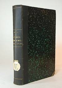
Rousset, Lieutenant-Colonel (Leonce).
Le 4e corps de l'Armee de Metz. 10 juillet - 27 octobre 1870. Avec sinq cartes et un portrait hors texte.
Paris Henri Charles-Lavauzelle 1898. 1st Edition . Hardcover. . ~ ~ NOTE: THE PRICE OF THIS BOOK IS CURRENTLY REDUCED! ~ ~ . Royal octavo. Pp. 384. Plus aquatint heliogravure frontispiece portrait with facing tissue guard. Plus 5 folding lithograph maps including chromolithographed large one. HARDCOVER bound in contemporary half cloth and marbled boards spine gilt shelf ticket to spine; corner-tips bumped inner hinges slightly cracked old military institutional stamp to title some foxing here and there. In a very good condition. ~ FIRST EDITION. Undated ca. 1898. Léonce Rousset 1850-1938. E-4 IN <br/> <br/> Paris, Henri Charles-Lavauzelle, (1898). hardcover
Référence libraire : 8940
|
|
|
Routley, Erik
English Religious Dissent
Cambridge University Press. Very Good with no dust jacket. 1960. First Edition. Hardcover. University library withdrawal still tight and clean in red cloth with sun strip to rear cover; empty due sheet to rear endpaper. ; English Institutions; 214 pages . Cambridge University Press hardcover
Référence libraire : 42647
|
|
|
Rouvelas, Marilyn; George Papaioannou; Illustrations By Olga Angelo Deoudes
A Guide to Greek Traditions and Customs in America - Second Edition
Bethesdam Maryland: Nea Attiki Press 2002. 2nd Edition . Hardcover. Fine/Fine. Xiv 411 Pp. Mauve Boards Spine Printed In Purple. Second Edition Revised And Expanded. Fine In Fine Dust Jacket Priced $30.00. Signed By The Author And Dated In 2009. <br/> <br/> Nea Attiki Press hardcover
Référence libraire : 057884 ISBN : 0963805118 9780963805119
|
|
|
Roux De Rochelle M.
Ville anseatiques.
Completo delle 24 carte incise compresa la carta geografica ripiegata. Collana "L'Univers Pittoresque".
|
|
|
ROUX Jean-Paul
L'Islam en Occident, Europe-Afrique
304pp., br.orig., 22cm., dans la série "Bibliothèque historique", bel état
|
|
|
ROUX Joseph (Attivo nella seconda metà del XVIII sec.)
(Golfo di Toulon)
Piano nautico tratto dal " Recueil des principaux plans des ports & rades de la Méditerranée" di Josepgh Roux, pubblicato per la prima volta a Marsiglia nel 1764 e successivamente ristampato - ampliato - a Genova da Yves Gravier con il titolo "Recueil de 163 principaux plans des ports et rades de la Mediterranée" (1804).Ulteriore edizione dell'opera, con il titolo "Plans des ports ed des rades de la Mer Méditerranée.." è stampata a Livorno da Carlo Tesi nel 1858. Incisione in rame, finemente acquarellata a mano, in ottimo stato di conservazione. First published in the "Recueil des principaux plans des ports et rades de la Mer Mediterranee", 1764, this nice nautical chart is taken from the rare "Plans des ports ed des rades de la Mer Méditerranée.." published in Leghorn by Carlo Tesi, 1858. Copperplate with fine colouring, in very good condition.

|
|
|
ROUX Joseph (Attivo nella seconda metà del XVIII sec.)
Baye d' Hieres
Piano nautico tratto dal " Recueil des principaux plans des ports & rades de la Méditerranée" di Josepgh Roux, pubblicato per la prima volta a Marsiglia nel 1764 e successivamente ristampato - ampliato - a Genova da Yves Gravier con il titolo "Recueil de 163 principaux plans des ports et rades de la Mediterranée" (1804).Ulteriore edizione dell'opera, con il titolo "Plans des ports ed des rades de la Mer Méditerranée.." è stampata a Livorno da Carlo Tesi nel 1858. Incisione in rame, finemente acquarellata a mano, in ottimo stato di conservazione. First published in the "Recueil des principaux plans des ports et rades de la Mer Mediterranee", 1764, this nice nautical chart is taken from the rare "Plans des ports ed des rades de la Mer Méditerranée.." published in Leghorn by Carlo Tesi, 1858. Copperplate with fine colouring, in very good condition.

|
|
|
ROUX Joseph (Attivo nella seconda metà del XVIII sec.)
Baye de Sofa
Piano nautico tratto dal " Recueil des principaux plans des ports & rades de la Méditerranée" di Josepgh Roux, pubblicato per la prima volta a Marsiglia nel 1764 e successivamente ristampato - ampliato - a Genova da Yves Gravier con il titolo "Recueil de 163 principaux plans des ports et rades de la Mediterranée" (1804).Ulteriore edizione dell'opera, con il titolo "Plans des ports ed des rades de la Mer Méditerranée.." è stampata a Livorno da Carlo Tesi nel 1858. Incisione in rame, finemente acquarellata a mano, in ottimo stato di conservazione. First published in the "Recueil des principaux plans des ports et rades de la Mer Mediterranee", 1764, this nice nautical chart is taken from the rare "Plans des ports ed des rades de la Mer Méditerranée.." published in Leghorn by Carlo Tesi, 1858. Copperplate with fine colouring, in very good condition.

|
|
|
ROUX Joseph (Attivo nella seconda metà del XVIII sec.)
Bouc
Piano nautico tratto dal " Recueil des principaux plans des ports & rades de la Méditerranée" di Josepgh Roux, pubblicato per la prima volta a Marsiglia nel 1764 e successivamente ristampato - ampliato - a Genova da Yves Gravier con il titolo "Recueil de 163 principaux plans des ports et rades de la Mediterranée" (1804).Ulteriore edizione dell'opera, con il titolo "Plans des ports ed des rades de la Mer Méditerranée.." è stampata a Livorno da Carlo Tesi nel 1858. Incisione in rame, finemente acquarellata a mano, in ottimo stato di conservazione. First published in the "Recueil des principaux plans des ports et rades de la Mer Mediterranee", 1764, this nice nautical chart is taken from the rare "Plans des ports ed des rades de la Mer Méditerranée.." published in Leghorn by Carlo Tesi, 1858. Copperplate with fine colouring, in very good condition.

|
|
|
ROUX Joseph (Attivo nella seconda metà del XVIII sec.)
Bouche de Cattero
Piano nautico tratto dal " Recueil des principaux plans des ports & rades de la Méditerranée" di Josepgh Roux, pubblicato per la prima volta a Marsiglia nel 1764 e successivamente ristampato - ampliato - a Genova da Yves Gravier con il titolo "Recueil de 163 principaux plans des ports et rades de la Mediterranée" (1804).Ulteriore edizione dell'opera, con il titolo "Plans des ports ed des rades de la Mer Méditerranée.." è stampata a Livorno da Carlo Tesi nel 1858. Incisione in rame, finemente acquarellata a mano, in ottimo stato di conservazione. First published in the "Recueil des principaux plans des ports et rades de la Mer Mediterranee", 1764, this nice nautical chart is taken from the rare "Plans des ports ed des rades de la Mer Méditerranée.." published in Leghorn by Carlo Tesi, 1858. Copperplate with fine colouring, in very good condition.

|
|
|
ROUX Joseph (Attivo nella seconda metà del XVIII sec.)
Corsica Plan de Porto Vecchio
Piano nautico tratto dal " Recueil des principaux plans des ports & rades de la Méditerranée" di Josepgh Roux, pubblicato per la prima volta a Marsiglia nel 1764 e successivamente ristampato - ampliato - a Genova da Yves Gravier con il titolo "Recueil de 163 principaux plans des ports et rades de la Mediterranée" (1804).Ulteriore edizione dell'opera, con il titolo "Plans des ports ed des rades de la Mer Méditerranée.." è stampata a Livorno da Carlo Tesi nel 1858. Incisione in rame, finemente acquarellata a mano, in ottimo stato di conservazione. First published in the "Recueil des principaux plans des ports et rades de la Mer Mediterranee", 1764, this nice nautical chart is taken from the rare "Plans des ports ed des rades de la Mer Méditerranée.." published in Leghorn by Carlo Tesi, 1858. Copperplate with fine colouring, in very good condition.

|
|
|
ROUX Joseph (Attivo nella seconda metà del XVIII sec.)
Fort de Brescon
Piano nautico tratto dal " Recueil des principaux plans des ports & rades de la Méditerranée" di Josepgh Roux, pubblicato per la prima volta a Marsiglia nel 1764 e successivamente ristampato - ampliato - a Genova da Yves Gravier con il titolo "Recueil de 163 principaux plans des ports et rades de la Mediterranée" (1804).Ulteriore edizione dell'opera, con il titolo "Plans des ports ed des rades de la Mer Méditerranée.." è stampata a Livorno da Carlo Tesi nel 1858. Incisione in rame, finemente acquarellata a mano, in ottimo stato di conservazione. First published in the "Recueil des principaux plans des ports et rades de la Mer Mediterranee", 1764, this nice nautical chart is taken from the rare "Plans des ports ed des rades de la Mer Méditerranée.." published in Leghorn by Carlo Tesi, 1858. Copperplate with fine colouring, in very good condition.

|
|
|
ROUX Joseph (Attivo nella seconda metà del XVIII sec.)
Golfo di Spalato
Piano nautico tratto dal " Recueil des principaux plans des ports & rades de la Méditerranée" di Josepgh Roux, pubblicato per la prima volta a Marsiglia nel 1764 e successivamente ristampato - ampliato - a Genova da Yves Gravier con il titolo "Recueil de 163 principaux plans des ports et rades de la Mediterranée" (1804).Ulteriore edizione dell'opera, con il titolo "Plans des ports ed des rades de la Mer Méditerranée.." è stampata a Livorno da Carlo Tesi nel 1858. Incisione in rame, finemente acquarellata a mano, in ottimo stato di conservazione. First published in the "Recueil des principaux plans des ports et rades de la Mer Mediterranee", 1764, this nice nautical chart is taken from the rare "Plans des ports ed des rades de la Mer Méditerranée.." published in Leghorn by Carlo Tesi, 1858. Copperplate with fine colouring, in very good condition.

|
|
|
ROUX Joseph (Attivo nella seconda metà del XVIII sec.)
Isle di Cherzo
Piano nautico tratto dal " Recueil des principaux plans des ports & rades de la Méditerranée" di Josepgh Roux, pubblicato per la prima volta a Marsiglia nel 1764 e successivamente ristampato - ampliato - a Genova da Yves Gravier con il titolo "Recueil de 163 principaux plans des ports et rades de la Mediterranée" (1804).Ulteriore edizione dell'opera, con il titolo "Plans des ports ed des rades de la Mer Méditerranée.." è stampata a Livorno da Carlo Tesi nel 1858. Incisione in rame, finemente acquarellata a mano, in ottimo stato di conservazione. First published in the "Recueil des principaux plans des ports et rades de la Mer Mediterranee", 1764, this nice nautical chart is taken from the rare "Plans des ports ed des rades de la Mer Méditerranée.." published in Leghorn by Carlo Tesi, 1858. Copperplate with fine colouring, in very good condition.

|
|
|
ROUX Joseph (Attivo nella seconda metà del XVIII sec.)
IV Feuille
IV.e Feuille / Avec Privilège du Roy à Marseille / Chez Joseph Roux Hydrographe du Roy / sur le Porte à S.t Jean 1764.Carta del Tirreno meridionale tratta da "Carte de la Mer Mediterranée en Douze Feuilles. Dediée a M.r le Duc de Choiseul Colonel Général des Suisses et Grisons, Ministre de la Guerre et de la Marine. Par son très humble Serviteur Joseph Roux Hydrographe du Roy, sur le port à S. t. Jean, à Marseille. Avec Privilège du Roy".È rappresentato il Mar Tirreno, con l'Italia centrale e meridionale, la Sicilia settentrionale e la parte occidentale di Corsica e Sardegna. La tavola costituisce il foglio n. 4 della grande carta del Mediterraneo in dodici fogli realizzata a Marsiglia da Joseph Roux nel 1764. Venne pubblicata sotto forma di atlante in 12 tavole nelle quali è rappresentato l'intero bacino del Mediterraneo ed il mar di Marmara, mentre il mar Nero ne rimane escluso. L’opera era dedicata al ministro della guerra e della Marina duca di Choiseul. Il taglio delle carte, le relative scale di riduzione adottate, il tipo di simboli usati, testimoniano una diretta derivazione dall'atlante nautico che Michelot e Bremond avevano realizzato 50 anni prima. A differenza di quello notiamo qui un maggior distacco dai modelli medioevali, sia per l'assenza di carte generali, sia per la disposizione delle rose dei venti secondo uno schema rettangolare e con le corse che si interrompono in prossimità delle coste. Anche la toponomastica appare ammodernata. Ai lati delle varie carte sono inoltre indicati i valori della latitudine.Acquaforte, finemente colorata a mano, in ottimo stato di conservazione. IV.e Feuille / Avec Privilege du Roy à Marseille / Chez Joseph Roux Hydrographe du Roy / sur le Porte à S.t Jean 1764.Taken from "Carte de la Mer Mediterranee en Douze Feuilles. Dediée a M.r le Duc de Choiseul Colonel General des Suisses et Grisons, Ministre de la Guerre et de la Marine. Par son très humble Serviteur Joseph Roux Hydrographe du Roy, sur le port a S. t. Jean, a Marseille. Avec Privilege du Roy", Marseille, 1764. It represented the Tyrrhenian Sea, with central and southern Italy, Sicily, North Africa and the western part of Corsica and Sardinia. The map represents the sheet n. 4 of the big chart of the Mediterranean published in Marseilles, in twelve sheets, made by Joseph Roux in 1764. Was published in the form of atlas in 12 plates in which is represented the whole basin of the Mediterranean and the Sea of Marmara. The work was dedicated to the Minister of War and Navy Duke of Choiseul. The cut of the charts, the relative scale of reduction taken, the type of symbols used, evidence of a direct derivation from the nautical atlas that Michelot and Bremond had built 50 years earlier. Perfect condition.

|
|
|
ROUX Joseph (Attivo nella seconda metà del XVIII sec.)
La Ciotat
Piano nautico tratto dal " Recueil des principaux plans des ports & rades de la Méditerranée" di Josepgh Roux, pubblicato per la prima volta a Marsiglia nel 1764 e successivamente ristampato - ampliato - a Genova da Yves Gravier con il titolo "Recueil de 163 principaux plans des ports et rades de la Mediterranée" (1804).Ulteriore edizione dell'opera, con il titolo "Plans des ports ed des rades de la Mer Méditerranée.." è stampata a Livorno da Carlo Tesi nel 1858. Incisione in rame, finemente acquarellata a mano, in ottimo stato di conservazione. First published in the "Recueil des principaux plans des ports et rades de la Mer Mediterranee", 1764, this nice nautical chart is taken from the rare "Plans des ports ed des rades de la Mer Méditerranée.." published in Leghorn by Carlo Tesi, 1858. Copperplate with fine colouring, in very good condition.

|
|
|
ROUX Joseph (Attivo nella seconda metà del XVIII sec.)
Plan du Port de Chatte
Piano nautico tratto dal " Recueil des principaux plans des ports & rades de la Méditerranée" di Josepgh Roux, pubblicato per la prima volta a Marsiglia nel 1764 e successivamente ristampato - ampliato - a Genova da Yves Gravier con il titolo "Recueil de 163 principaux plans des ports et rades de la Mediterranée" (1804).Ulteriore edizione dell'opera, con il titolo "Plans des ports ed des rades de la Mer Méditerranée.." è stampata a Livorno da Carlo Tesi nel 1858. Incisione in rame, finemente acquarellata a mano, in ottimo stato di conservazione. First published in the "Recueil des principaux plans des ports et rades de la Mer Mediterranee", 1764, this nice nautical chart is taken from the rare "Plans des ports ed des rades de la Mer Méditerranée.." published in Leghorn by Carlo Tesi, 1858. Copperplate with fine colouring, in very good condition.

|
|
|
ROUX Joseph (Attivo nella seconda metà del XVIII sec.)
Plan du Port de Cherse
Piano nautico tratto dal " Recueil des principaux plans des ports & rades de la Méditerranée" di Josepgh Roux, pubblicato per la prima volta a Marsiglia nel 1764 e successivamente ristampato - ampliato - a Genova da Yves Gravier con il titolo "Recueil de 163 principaux plans des ports et rades de la Mediterranée" (1804).Ulteriore edizione dell'opera, con il titolo "Plans des ports ed des rades de la Mer Méditerranée.." è stampata a Livorno da Carlo Tesi nel 1858. Incisione in rame, finemente acquarellata a mano, in ottimo stato di conservazione. First published in the "Recueil des principaux plans des ports et rades de la Mer Mediterranee", 1764, this nice nautical chart is taken from the rare "Plans des ports ed des rades de la Mer Méditerranée.." published in Leghorn by Carlo Tesi, 1858. Copperplate with fine colouring, in very good condition.

|
|
|
ROUX Joseph (Attivo nella seconda metà del XVIII sec.)
Port S.e Anne de Morgò
Piano nautico tratto dal " Recueil des principaux plans des ports & rades de la Méditerranée" di Josepgh Roux, pubblicato per la prima volta a Marsiglia nel 1764 e successivamente ristampato - ampliato - a Genova da Yves Gravier con il titolo "Recueil de 163 principaux plans des ports et rades de la Mediterranée" (1804).Ulteriore edizione dell'opera, con il titolo "Plans des ports ed des rades de la Mer Méditerranée.." è stampata a Livorno da Carlo Tesi nel 1858. Incisione in rame, finemente acquarellata a mano, in ottimo stato di conservazione. First published in the "Recueil des principaux plans des ports et rades de la Mer Mediterranee", 1764, this nice nautical chart is taken from the rare "Plans des ports ed des rades de la Mer Méditerranée.." published in Leghorn by Carlo Tesi, 1858. Copperplate with fine colouring, in very good condition.

|
|
|
ROUX Joseph (Attivo nella seconda metà del XVIII sec.)
Port Vendre en Roussillon
Piano nautico tratto dal " Recueil des principaux plans des ports & rades de la Méditerranée" di Josepgh Roux, pubblicato per la prima volta a Marsiglia nel 1764 e successivamente ristampato - ampliato - a Genova da Yves Gravier con il titolo "Recueil de 163 principaux plans des ports et rades de la Mediterranée" (1804).Ulteriore edizione dell'opera, con il titolo "Plans des ports ed des rades de la Mer Méditerranée.." è stampata a Livorno da Carlo Tesi nel 1858. Incisione in rame, finemente acquarellata a mano, in ottimo stato di conservazione. First published in the "Recueil des principaux plans des ports et rades de la Mer Mediterranee", 1764, this nice nautical chart is taken from the rare "Plans des ports ed des rades de la Mer Méditerranée.." published in Leghorn by Carlo Tesi, 1858. Copperplate with fine colouring, in very good condition.

|
|
|
ROUX Joseph (Attivo nella seconda metà del XVIII sec.)
Porto di S.t Geoge fur l'Isle de Liba
Piano nautico tratto dal " Recueil des principaux plans des ports & rades de la Méditerranée" di Josepgh Roux, pubblicato per la prima volta a Marsiglia nel 1764 e successivamente ristampato - ampliato - a Genova da Yves Gravier con il titolo "Recueil de 163 principaux plans des ports et rades de la Mediterranée" (1804).Ulteriore edizione dell'opera, con il titolo "Plans des ports ed des rades de la Mer Méditerranée.." è stampata a Livorno da Carlo Tesi nel 1858. Incisione in rame, finemente acquarellata a mano, in ottimo stato di conservazione. First published in the "Recueil des principaux plans des ports et rades de la Mer Mediterranee", 1764, this nice nautical chart is taken from the rare "Plans des ports ed des rades de la Mer Méditerranée.." published in Leghorn by Carlo Tesi, 1858. Copperplate with fine colouring, in very good condition.

|
|
|
ROUX Joseph (Attivo nella seconda metà del XVIII sec.)
Porto di Ville Franche
Piano nautico tratto dal " Recueil des principaux plans des ports & rades de la Méditerranée" di Josepgh Roux, pubblicato per la prima volta a Marsiglia nel 1764 e successivamente ristampato - ampliato - a Genova da Yves Gravier con il titolo "Recueil de 163 principaux plans des ports et rades de la Mediterranée" (1804).Ulteriore edizione dell'opera, con il titolo "Plans des ports ed des rades de la Mer Méditerranée.." è stampata a Livorno da Carlo Tesi nel 1858. Incisione in rame, finemente acquarellata a mano, in ottimo stato di conservazione. First published in the "Recueil des principaux plans des ports et rades de la Mer Mediterranee", 1764, this nice nautical chart is taken from the rare "Plans des ports ed des rades de la Mer Méditerranée.." published in Leghorn by Carlo Tesi, 1858. Copperplate with fine colouring, in very good condition.

|
|
|
 Recevoir par e-mail
 Télécharger en PDF
 Flux RSS


