|
|
|
[United States Geological Survey of the Kingdom of Saudi Arabia].
Saudi Arabia Geologic Maps (GM) series. 6 maps. [Reston, VA] / Jiddah, Ministry of Petroleum and Mineral Resources, Deputy Ministry for Mineral Resources, 1975-1991.
6 maps, colour printed. Scales: 1:100,000; 1:250,000; 1:2,500,000. All in their original printed orange and green envelopes, all but one with accompanying booklets. Six maps from the USGS's premier Geologic and Geoscience series (English and Arabic text), focusing on the west of the Arabian Peninsula. Originally compiled from field mapping carried out at the 1:100,000 scale, though scales here vary. Maps include keys and cross-sections, and sometimes an accompanying booklet of detailed explanatory notes. Comprises individually: - 1) GM-22 (IR 182; Vranas p. 17): Geology of the Jabal Ibrahim Quadrangle, Sheet 20 / 41C, by W. R. Greenwood, with a Section on Economic Geology, by R. G. Worl and W. R. Greenwood, 82 x 74 cm, 1:100,000, 1975 (1976). Based on mapping done Dec. 1970-Jan. 1971. With 18 pp. staple-bound illustrated notes as called for. - 2) GM-28: Geology of the Nuqrah Quadrangle, sheet 25E, by J. Delfour, 106 x 62 cm, 1:250,000, 1977. Includes 18 pp. staple-bound illustrated notes by J. Delfour. This area lies a little to the north of Medina. Original mapping is credited to the Bureau de Recherches Geologiques et des Minieres. - 3) GM-66 - Plate 2: Mineral locality maps of Saudi Arabia, by Hans van Daalhoff, 71 x 96 cm, 1:2,500,000, 1982. This map is a reduction of the Anglo-American / USGS Map I-270-B2 (1963) and includes a large stretch of the Red Sea coast including the Holy Sites, part of Qatar, and the major oil producing locations on the Arabian Gulf. - 4) GM-78A (IR 383; Vranas p. 33): Geologic map of the Najran quadrangle, Sheet 17G (with Landsat base), by Edward G. Sable, 109 x 64 cm, 1:250,000, 1985. Includes 18 pp. staple-bound illustrated "Explanatory Notes" by Sable as called for (though Vranas confusingly indicates this should also include an additional geographic map, and the booklet be 35 pp.). - 5) GM-122: Industrial mineral resources map of Jiddah, by C. H. Spencer, Alain Cartier, and Pierre Louis Vincent, in two sheets, 1988. 1:100,000. 2 sheets (Jiddah East; Jiddah West), each 102 x 76 cm. Includes 15 pp. staple-bound illustrated notes by Spencer, Cartier and Vincent. - 6) GM-132: Geologic map of the Cenozoic Lava field of Harrat Kishb, by M. John Roobol and Victor E. Camp, 86 x 76 cm, 1:250,000, 1991. Includes 34 pp. staple-bound illustrated notes by Roobol and Camp. - Very well preserved in general. G. J. Vranas, List of Interagency Reports submitted by the US Geological Survey Saudi Arabian Mission to the Saudi Arabian Directorate General of Mineral Resources from 1965 to the beginning of 1992 (Open File Report USGS-OF-92-2. Interagency Report 844 (Jiddah: Ministry of Petroleum and Mineral Resources Directorate General of Mineral Resources, 1412 AH/1992 AD), pp. 17, 33.
|
|
|
[United States Geological Survey of the Kingdom of Saudi Arabia].
Saudi Arabia Index Maps (1:4,000,000). 6 maps. [Reston, VA] / Jiddah, Ministry of Petroleum and Mineral Resources, Deputy Ministry for Mineral Resources, 1980-1981.
6 maps, 70 x 61 cm to ca. 75 x 65 cm. Printed in black and white. Constant ratio linear horizontal scale 1:4,000,000 scale. All in their original printed orange envelopes. Of the eight index maps produced during 1980-81, six are included here (wanting 100 [IR 400] and 107 [IR 407]). They feature the Arabian Peninsula, with labels for Mecca, Medina, Jeddah, Riyadh, Dammam, Sharjah, Masqat, Kuwayt etc. Comprises individually: - 101 (IR 401): Index Map of 1:250,000 scale quadrangle maps; 102 (IR 402): Index map of Landsat imagery of the Arabian Peninsula: Path 169 through 189, Row 38 through 51; 103 (IR 403): Index map of 1:50,000 scale mosaics, SAG and GSMO photography 1950-53; 104 (IR 404): Index map of 1:100,000 scale mosaics and photo maps, SAG and GSMO photography 1950-53; 105 (IR 405): Index map of 1:100,000 scale mosaics, WSA photography 1955-57; 106 (IR 406): Index map of 1:50,000 scale mosaics, WSA photography 1955-57. - In excellent condition throughout. G. J. Vranas, List of Interagency Reports submitted by the US Geological Survey Saudi Arabian Mission to the Saudi Arabian Directorate General of Mineral Resources from 1965 to the beginning of 1992 (Open File Report USGS-OF-92-2. Interagency Report 844 (Jiddah: Ministry of Petroleum and Mineral Resources Directorate General of Mineral Resources, 1412 AH/1992 AD), pp. 71, 35f.
|
|
|
[United States Geological Survey of the Kingdom of Saudi Arabia].
Saudi Arabia Landsat Image Maps (1:250,000). 20 maps. [Reston, VA] / Jiddah, Ministry of Petroleum and Mineral Resources, Deputy Ministry for Mineral Resources, 1979-1981.
20 maps, 84 x 53 cm or larger. Printed in brown tones. Transverse Mercator projection, constant ratio linear horizontal scale 1:250,000 scale. All but two in their original printed orange envelopes. The joint NASA/USGS Landsat Programme started in the early 1970s, providing the longest continuous space-based record of the Earth’s surface. Of the 25 maps in 1:250,000 scale produced during 1979-81, 20 are included here (wanting 2, 3, 4 [IR 301, 302, 303], 13 [IR 312], 16 [IR 315]). They cover the stretch of the Red Sea coast from just below the Gulf of Aqaba to just below Jeddah, and inland from Jeddah towards Dammam via Riyadh. Comprises individually: - 1 (IR 300): Jabal Al Hasir Quadrangle, Sheet 19F, 1979; 5 (IR 304): Jibal Hayil Quadrangle, Sheet 17E, 1980; 6 (IR 305): Al Qunfudhah Quadrangle, Sheet 19E, 1980; 7 (IR 306): Wadi Hali Quadrangle, Sheet 18E, 1980; 8 (IR 307): Jizan Quadrangle, Sheet 16F, 1980; 9 (IR 308): Jibal Al Qahr Quadrangle, Sheet 19G, 1981; 10 (IR 309): Bi’r Idimah Quadrangle, Sheet 18G, 1981; 11 (IR 310): Jaza’ir Farasan Quadrangle, Sheet 16E, 1980; 12 (IR 311): Wadi Bishah Quadrangle, Sheet 20F, 1981; 14 (IR 313): Al Lith Quadrangle, Sheet 20D, 1981; 15 (IR 314): Wadi Tathlith Quadrangle, Sheet 20G, 1981; 17 (IR 316): Turabah Quadrangle, Sheet 21E, 1981; 18 (IR 317): Ar Rawdah Quadrangle, Sheet 21F, 1981; 19 (IR 318): Jabal Tarban Quadrangle, Sheet 21G, 1981; 20 (IR 319): Rabigh Quadrangle, Sheet 22D, 1981; 21 (IR 320): Al Muwayh Quadrangle, Sheet 22E, 1981; 22 (IR 321): Zalim Quadrangle, Sheet 22F, 1981; 23 (IR 322): Wadi Ar Rika’ Quadrangle, Sheet 22G, 1981; 24 (IR 323): Al Mulayh Quadrangle, Sheet 22H, 1981; 25 (IR 324): Al Ji’lan Quadrangle, Sheet 21H, 1981. - Envelope and map of no. 10 stamped with initials and date (TRU May 1981) and a couple of nicks to map edge, otherwise excellent throughout. G. J. Vranas, List of Interagency Reports submitted by the US Geological Survey Saudi Arabian Mission to the Saudi Arabian Directorate General of Mineral Resources from 1965 to the beginning of 1992 (Open File Report USGS-OF-92-2. Interagency Report 844 (Jiddah: Ministry of Petroleum and Mineral Resources Directorate General of Mineral Resources, 1412 AH/1992 AD), pp. 71, 26-29.
|
|
|
[United States Geological Survey of the Kingdom of Saudi Arabia].
Saudi Arabia Landsat Image Maps (1:500,000). 4 maps. [Reston, VA] / Jiddah, Ministry of Petroleum and Mineral Resources, Deputy Ministry for Mineral Resources, 1980.
4 maps, 86 x 98 cm to 104 x 102 cm. Printed in brown tones. Transverse Mercator projection, constant ratio linear horizontal scale 1:500,000 scale. All maps but one (32) in their original printed orange envelopes. The joint NASA/USGS Landsat Programme started in the early 1970s, providing the longest continuous space-based record of the Earth’s surface. Of the five produced in 1:500,000 scale, all but one (no. 34 [IR 333]) are included here. (As Vranas notes, numbers 26-31 and 35-37 were never produced.) They focus on the southwestern portion of the Peninsula; map 32 shows Mecca and Jeddah, though they are not marked. Comprises individually: - 32 (IR 331): Southern Hijaz Quadrangle; 33 (IR 332): Southern Najd Quadrangle; 38 (IR 337): Tihamat Ash Sham Quadrangle; 39 (IR 338): ‘Asir Quadrangle. - In excellent condition throughout. G. J. Vranas, List of Interagency Reports submitted by the US Geological Survey Saudi Arabian Mission to the Saudi Arabian Directorate General of Mineral Resources from 1965 to the beginning of 1992 (Open File Report USGS-OF-92-2. Interagency Report 844 (Jiddah: Ministry of Petroleum and Mineral Resources Directorate General of Mineral Resources, 1412 AH/1992 AD), pp. 71, 26-29.
|
|
|
[United States Geological Survey of the Kingdom of Saudi Arabia].
Saudi Arabia Landsat Image Maps, OF-02 series (1:250,000 and 1:500,000). 27 maps. [Reston, VA] / Jiddah, Ministry of Petroleum and Mineral Resources, Deputy Ministry for Mineral Resources, 1982.
27 maps, ca. 54 x 84 cm to 104 x 98 cm. Printed in brown tones. Transverse Mercator projection, constant ratio linear horizontal scale 1:250,000 scale (except for OF-02-32 through 02-35, which are on a scale of 1:500,000). All in their original printed orange envelopes. The joint NASA/USGS Landsat Programme started in the early 1970s, providing the longest continuous space-based record of the Earth’s surface. Its "OF" (Open File reports) series was designed to publish urgent interim or preliminary information edited with only a single peer review. As of 1992, 11 sets had been produced, which included a mixture of maps and other documents, prefixed OF-01 through OF-10 and OF-92. The present set comprises 27 maps from the 91 documents that made up the OF-02 set. Comprises individually: - OF-02-12 (IR 325): Halaban Quadrangle, Sheet 23G; OF-02-14 (IR 327): Al Hawtah Quadrangle, Sheet 23I; OF-02-15 (IR 328): Yabrin Quadrangle, Sheet 23J; OF-02-16 (IR 329): Ad Dawadimi Quadrangle, Sheet 24G; OF-02-17 (IR 330): Durma Quadrangle, Sheet 24H; OF-02-19 (IR 335): Harad Quadrangle, Sheet 24J; OF-02-20 (IR 336): Aban Al Ahmar Quadrangle, Sheet 25F; OF-02-21 (IR 339): Al Faydah Quadrangle, Sheet 25G; OF-02-22 (IR 340): Shaqra Quadrangle, Sheet 25H; OF-02-23 (IR 341): Rumah Quadrangle, Sheet 25I; OF-02-24 (IR 419): Jabal Habashi quadrangle, Sheet 26F; OF-02-25 (IR 420): Buraydah Quadrangle, Sheet 26G; OF-02-26 (IR 421): Qiba Quadrangle, Sheet 27G; OF-02-27 (IR 422): Mahd Adh Dhahab Quadrangle, Sheet 23E; OF-02-28 (IR 423): 'Afif Quadrangle, Sheet 23F; OF-02-29 (IR 424): Al Hissu Quadrangle, Sheet 24E; OF-02-31 (IR 426): Baq'A' Quadrangle, Sheet 27F; OF-02-32 (IR 427): Wadi As Sirhan Quadrangle; OF-02-33 (IR 428): Northwestern Hijaz Quadrangle, 104 x 98 cm; OF-02-34 (IR 429): Northeastern Hijaz Quadrangle, 80 x 100cm, OF-02-35 (IR 430): Wadi Ar Rimah Quadrangle, 83 x 100 cm; OF-02-72 (IR 476): Sahl Al Matran Quadrangle, Sheet 26C; OF-02-73 (IR 477): Harrat Ithnayn Quadrangle, Sheet 26D; OF-02-74 (IR 478): Wadi Ash Sha'bah Quadrangle, Sheet 26E; OF-02-75 (IR 479): Al Muwaylih Quadrangle, Sheet 27A; OF-02-76 (IR 480): Shaghab Quadrangle, Sheet 27B; OF-02-79 (IR 483): Ha'il Quadrangle, Sheet 27E. - In excellent condition throughout. G. J. Vranas, List of Interagency Reports submitted by the US Geological Survey Saudi Arabian Mission to the Saudi Arabian Directorate General of Mineral Resources from 1965 to the beginning of 1992 (Open File Report USGS-OF-92-2. Interagency Report 844 (Jiddah: Ministry of Petroleum and Mineral Resources Directorate General of Mineral Resources, 1412 AH/1992 AD), pp. 75f., 28-42.
|
|
|
[Urquhart, David].
Turkey and its resources: its municipal organization and free trade; the state and prospects of English commerce in the East, the new administration of Greece, its revenue and national possessions. London, Saunders and Otley, 1833.
8vo. First edition. XV, (1), 328 pp. With lithographic map bound as frontispiece. First edition; flyleaf inscribed by the author to "Mr A. Regnaudin". Important overview of Turkish trade, resources, infrastructure and municipal organisation by the diplomat David Urquhart (1805-77). After two and a half years fighting in the Greek war of independence, Urquhart was invited to accompany Sir Stratford Canning to Constantinople in November 1831 as an advisor during negotiations to settle the Greek boundary. In 1832 Urquhart was sent to Albania to cultivate the support of Rechid Pasha, leading advisor to the Turkish sultan. Urquhart became a great supporter of Turkey, spending most of 1834 in the country, and encouraged the British government to ally itself with Turkey against Egypt. This substantial book was written to inform the British political class of the possible commercial benefits of an Anglo-Turkish alliance. - Some negligible toning to first few leaves. Very good, uncut in original grey paper-covered boards, spine with original printed label, light wear to extremities. Scarce, particularly in original condition as here. Goldsmiths’ 27883. OCLC 65261681.

|
|
|
[Van Ess, John, et al.].
Historical Mesopotamia. (Basrah, Times Press, 1922].
4to (170 x 202 mm). (6), 58 pp. With 8 photographic plates and one map. Original pictorial grey wrappers. Ten excellent short essays on Mesopotamia (modern-day Iraq), printed at the Times offices in Basra. According to the preface, the pamphlet was published in response to growing curiosity about the country, sparked by British involvement post-WWI. Most of the essays, as per the title, focus on the distant past, taking the reader to the founding of Baghdad in the eighth century, Basra in the Middle Ages and the construction of the Ctesiphon Arch (Taq Kasra). The latter is one of the finer pieces, providing a brief but detailed account of the creation of the structure and its completed finery, drawing on Gertrude Bell's musical translation of al-Tabari's description of the famous carpet "woven in the pattern of a garden" (Amurath to Amurath). - Other essays turn to the early twentieth century and contemporary life. The piece on Mandaeism, in addition to outlining its history, features a short interview with a group of Mandaeans from the Mesopotamian Marshes, in which they discuss their beliefs and religious practices. The final essay, by the missionary John Van Ess (the only contributor to give his full name), reflects on his time in Mesopotamia among certain rural tribes, highlighting episodes of kindness and hospitality. Van Ess (1878-1949) is notable for the time he spent in Mesopotamia (nearly fifty years), his role as an advisor to British officials and, in that capacity, for his opposition to making Faisal King. - With contemporary ink ownership of A. H. Lee on the front cover. Remnants of postage stamps on rear wrapper, slight repair to spine. Exceedingly rare: only two intact copies known, in the British Library Reference Collections and in the National Library of Scotland; the Munich University Library appears to own an incomplete copy. OCLC 562435427.
|
|
|
[VAN HAMME] - BECKFORD (William).-
Vathek. Préface de Stéphane Mallarmé. Illustrations de Van Hamme.
1971 Grenoble, Roissart, 1971, in 8° broché, XXX-124 pages ; couverture rempliée, sous double emboîtage de toile marron de l'éditeur.
Référence libraire : 84864
|
|
|
[Victor CHERBULIEZ] G VALBERT
Le Maroc et la politique européenne à Tanger. Extrait de la Revue des Deux Mondes
Extrait de La Revue des deux mondes | s. l. [Paris] 1884 | 15.50 x 25 cm | agrafé
Référence libraire : 15689
|
|
|
[Victor CHERBULIEZ] G VALBERT
Le régime du protectorat en Tunisie. Extrait de la Revue des Deux Mondes
Extrait de La Revue des deux mondes | s. l. [Paris] (1886) | 15.50 x 25 cm | agrafé
Référence libraire : 14790
|
|
|
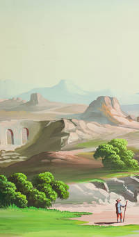
[VIEW - MIDDLE EAST].
Mountainous landscape with Middle Eastern and classical Roman ruins 6 shepherds with their flocks several figures riding dromedaries and one riding a donkey date palms lakes etc. Palestine ca. 1910. An enormous panoramic view drawn in coloured gouaches on a single continuous roll of paper 70 x 583 cm the drawing running to the edges of the paper.
A panoramic view of what appears to be a fantasy Middle Eastern landscape with spectacular mountains in the background a body of water near each end and a wide variety of buildings and ruins some clearly classical Roman and others Middle Eastern. The combination of classical Roman architecture with dromedaries and other Middle Eastern features places it very likely in Palestine but we have not been able to identify specific buildings. The most distinctive ruin a round Roman temple with five columns on the viewer's side an entablature above them and a vertical base below them looks more like the Temple of the Vesta at Tivoli than like any known in the Middle East the columns are not rendered in sufficient detail to determine their order but they are almost certainly not Ionic and are probably Corinthian. There are also classical Roman aqueducts. The six shepherds with their flocks all wear broad-brimmed hats and have staffs and two are blowing long slightly curved horns. Several more figures with broad-brimmed hats and staffs might be pilgrims one together with what is presumably his wife. With a 33 cm tear into the left end a few insignificant and much smaller tears and with pin holes about 1 cm from the edges from mounting on a wall but otherwise in very good condition and with the colours fresh and bright. A spectacular panoramic view of the Middle East including many classical Roman ruins. unknown
Référence libraire : J68AIMO7W1D1
|
|
|
[View - Middle East].
Mountainous landscape with Middle Eastern and classical Roman ruins, 6 shepherds with their flocks, several figures riding dromedaries and one riding a donkey, (date?) palms, lakes, etc. [Palestine?, ca. 1910?].
An enormous panoramic view drawn in coloured gouaches on a single, continuous roll of unwatermarked wove paper (70 x 583 cm), the drawing running to the edges of the paper. Rolled and stored in a cardboard tube. A panoramic view of what appears to be a fantasy Middle Eastern landscape, with spectacular mountains in the background, a body of water near each end, and a wide variety of buildings and ruins, some clearly classical Roman and others Middle Eastern. The combination of classical Roman architecture with dromedaries and other Middle Eastern features places it very likely in Palestine, but we have not been able to identify specific buildings. The most distinctive ruin, a round Roman temple with five columns on the viewer's side (perhaps a third of the circle), an entablature above them and a vertical base below them, looks more like the Temple of the Vesta at Tivoli than like any known temple in the Middle East (the columns are not rendered in sufficient detail to determine their order, but they are almost certainly not Ionic and are probably Corinthian). There are also classical Roman aqueducts. The six shepherds with their flocks all wear broad-brimmed hats and have staffs, and two are blowing long, slightly curved horns. Several additional figures with broad-brimmed hats and staffs might be pilgrims, one together with what is presumably his wife. - With a 33 cm tear into the left edge, slightly affecting a mountain and the top of a tree, a few insignificant and much smaller tears and with pin holes about 1 cm from the edges from mounting on a wall, but otherwise in very good condition and with the colours fresh and bright. A spectacular panoramic view of the Middle East, including many classical Roman ruins.
|
|
|
[View - Optics - Mecca].
Vue du Port et de la Ville de Lamekk dans Larabie heureuse a 5 lieues de la Mer Rouge. [Paris, Louis Mondhare, 1750].
Optica-print view of Mecca on laid paper (32 x 46 cm), with some parts highlighted in contemporary hand colour. An imaginary view of the port of Mecca, showing the supposed harbour connected to the Red Sea, published by Louis Mondhare, a well-known publisher of so-called optica prints. The print, meant for viewing through a "zograscope" - a viewer with a large lens and mirror giving an illusion of depth - emphasizes perspective and shows the straight lines characteristic of optica prints. In good condition, crudely hand-coloured.
|
|
|
[War Office - General Staff].
Persian Gulf. Sheet 32. London, Field Survey Company, 1941.
990 x 760 mm. Scale 1 : 4000000. Third edition. Topographical map of the Arabian Gulf and surrounding area showing international boundaries, main cities and towns, roads, railways, islands, rivers, lakes, wetlands and other vegetation and terrain features. Extends from the Caspian Sea south to Mecca and from Cairo east to Meshed. Relief shown by contours, altitude tints and spot heights. Includes legend, index to adjoining sheets, administrative index, and bibliographical references. - Slightly creased.
|
|
|
[Wasf al-Rusul].
Kitab wasf al-Rusul wa al-Imama. [Near East, no date, but apparently ca. 1820 / early 19th century].
Small folio (ca. 210 x 300 mm). 74 pp. Arabic manuscript in black Naskh, headings and key words in red, ruled in red (often to form tables and geometric patterns). Several diagrams, 2 ff. with circular diagrams, some ruled leaves blank. Contemporary limp leather. A theological manuscript entitled "The book of description (or attributes) of the Prophet and the Leader". - Binding a little rubbed, spine chipped. A few leaves loosened. Some light staining and finger-soiling throughout; a few ink smudges; a number of edge tears (some professionally repaired).

|
|
|
[Wellsted, James Raymond].
Reiseskizzen aus Arabien. Oman und die Küste des persischen Golfs (Nach Wellstedt). In: Meyer's Volksbibliothek für Länder-, Völker- und Naturkunde. 76. Band. Hildburghausen & New York, Bibliographisches Institut / Hermann J. Meyer, [1855].
12mo. 161-197 pp.; entire work: 221, (3) pp. With 3 folding engr. plates. Original printed wrappers. Rare German translation of Wellsted's account of Oman. J. R. Wellsted's short career was almost entirely devoted to the surveying of the Red Sea, Arabia and Oman, undertaken on a number of expeditions between 1830 and 1837. On board the surveying ship Palinurus he was the first European to set foot in the interior of Oman. Starting late in 1835 from the easternmost point of Oman, Wellsted made his way westward through the Ja`alan region to the Wahibah Sands and then struck north up the Wadi Batha to Samad. There he was joined by Lieutenant F. Whitelock, also of the Indian Navy, who had set out from Muscat later. Together they reached Nazwa, the ancient capital of Oman, and climbed the lower slopes of the Jabal al-Akhdhar, in central Oman. In January 1836 they arrived on the Al-Batinah coast and then turned west, recrossing the Hajar mountains and emerging on the edge of the Dhaharah, the rocky steppe that stretches west toward the Rub` al-Khali. - Somewhat foxed throughout. Uncut, untrimmed copy. OCLC 162829268.

|
|
|
[Wilson, Arnold Talbot].
A Sketch of the Political History of Persia, Iraq and Arabia, With Special Reference to the Present Campaign. Calcutta, Government Press, 1917.
Small 8vo. (6), 43, (1) pp. Stiff green cloth wrappers titled in black. Extremely rare manual, marked "For Official use only" and prepared for the troops of the Indian Expeditionary Force "D", giving an account of the political and historical context of the British Mesopotamian campaign of World War I. - Expeditionary Force "D" was made up of Indian and British troops and is infamous for its doomed defense of the siege of Kut, where disease and starvation forced a surrender in April 1916. However, the pamphlet does not limit itself to Iraq, but crucially provides an entire chapter on the history of, and British interest in, the Arabian Peninsula, titled "Arabia - Our Left Flank", including an entire section on Abdulaziz Ibn Saud (1875-1953). The author summarizes the history of British presence in the Gulf, noting the sack of Ras-al-Khaimah in retribution for alleged pirate activity, after which "the climate forced [the British] to evacuate that position". The book further refers to the "maritime truce" imposed by Britain upon the Arabian Coast from "Masandam to Kuwait" in 1836 and notes that the suppression of the arms trade in Muscat was successful thanks to the regulations put in place by Faisal bin Turki, Sultan of Muscat and Oman (1864-1913), the direct ancestor of Sultan Haitham. In more general terms the author describes "The rich oases of the Qasim, with their population of enterprizing merchants" and "the Hasa, coveted for its date groves and its ports on the Persian Gulf" which "was finally wrested from the Ottoman Government by Ibn Sa'ud in 1913". The author lists British treaties along the Gulf Coast, including with "the Shaikh of Bahrain" (Abdullah bin Ahmad Al Khalifa, 1769-1849) in 1820 "and in 1798 with the chiefs of the Trucial Coast". - Cloth gently rubbed. Interior shows a hint of foxing, otherwise in very good condition. A single copy is listed in auction records, and that volume included a pencil note attributing authorship to Sir Arnold Talbot Wilson (1884-1940), a captain in the British Indian Army. As then-acting civil commissioner for Mesopotamia who later became known for his strong opinions on the postwar fate of Iraq, he is not an unlikely candidate.
|
|
|
[World Map - Islamic Manuscript].
Map of the world centred on the Arabian Gulf, showing seven mosques or minarets. Northern India or Kashmir?, ca. 1790 / late 18th century copy of a 16th century (?) original.
500 x 420 mm. Oval manuscript map in ink and watercolour (blue, brown, green and red; map image including water 295 x 380 mm, the land alone 220 x 305 mm) on a half sheet of extremely large Dutch laid paper (watermark: D&C Blauw IV), with dozens of features labelled in Persian (written in black ink in the nastaliq script) and with animals (including elephants and a dragon), people and 4 European ships. Framed and matted. An 18th century manuscript copy, in colour, of a lost map in the Islamic tradition, with dozens of inscriptions in Persian and extensive pictorial imagery showing numerous mosques, elephants in southern Africa, eastern India and what may be northern Bengal or part of Southeast Asia, snakes and a dragon (with four feet and two pair of wings) in East Asia, birds north of the Caucasus and people in Europe north of the Alps. The regions with people and animals (excluding the dragon and snakes) are also the only regions shown wooded. The oval land is surrounded by oceans with a European ship at each of the four cardinal compass directions: three 3-masted ships flying flags with St George's cross (used by the crusaders, Knights Templar and English and French troops from the 12th century and by the Genoese and others from the 13th century: while it is not St George come to slay the dragon, these European ships in an Islamic map remain a puzzle), and at the south a 2-masted ship with no rectangular flag, all four ships accompanied by rowboats. Inlets can be identified as the Arabian Gulf, the Gulf of Oman, the Red Sea, the Mediterranean, the Black Sea (?) and another in the Far East. A wide straight band of mountains runs west to east from coast to coast, apparently representing the Alps, the Caucasus and the Himalayas, with a few additional mountains in southern India and elsewhere. One can clearly see the Tigris and Euphrates rivers as well as the rivers of the Indus and Ganges valleys. After one passes beyond Bengal it becomes more difficult to identify the topographic features that ought to represent Southeast and East Asia: there is no island to represent Japan, and the peninsula that faintly resembles Korea seems more likely to be China. While some pictorial elements and lettering are designed to be viewed from various sides as one turns the map, there is a distinct bias in the lettering and some of the pictures for west at the head, which is quite unusual (most Islamic maps have south at the head). - We have found no record of any closely similar map, but the topography certainly owes something to the traditional Islamic world maps, perhaps by the 10th-century Abu al-Hasan al-Harrani or his followers such as the 15th-century Ibn al-Wardi. Like most maps in the Islamic tradition (including those of al-Bakri and al-Istakhri), these follow the Greek tradition of Anaximander (6th century BC) in depicting the world as an almost perfectly geometric circle surrounded by the great river or sea Oceanus, and also representing other features with abstract forms. They show the Nile running into the Mediterranean and (almost as its continuation north of the Mediterranean) a channel leading to the Black Sea, which continues via the river Phasis to the northern coast, forming a boundary between Europe and Asia. The present map is much more naturalistic, with an oval form and irregular coastlines. The inlets and rivers also have more naturalistic forms, and the map shows much more detail than do the traditional Greek and Islamic maps (one can recognize Qatar and Ceylon/Sri Lanka, and one of the two islands in the Mediterranean probably represents Crete (is the other Ceylon, Sicily, an oversized Malta, or something else?). Yet in spite of its greater detail and naturalism, its geography is in some ways less accurate than that of its more abstract ancestors. Like the al-Harrani and al-Wardi maps, the Nile has an L shape (though not rigidly geometric like theirs), but the southern end connects to the Red Sea and the northern end passes east of the Mediterranean, continuing directly into the channel leading to the northern coast (with no graphic distinction between the Black Sea and the channel to Oceanus). The Nile also appears to contain an enormous island, but the tower at its northern end might possibly represent the 13th-century minaret at Luxor. The Mediterranean appears as a triangular inlet without even a bulge to suggest Greece or Italy, which many Islamic and Greek maps show clearly. Africa and India extend no farther south than the Arabian Peninsula, with only the Red Sea and the Gulfs separating them. Some Mughal maps, such as that of Sadiq Isfahani (ca. 1647), share the more naturalistic depiction, and Isfahani also depicts Ceylon similarly, but his map shows few geographic or topographic similarities. - Perhaps the most remarkable feature of the present map is the depiction of mosques and minarets, which are so detailed that many can be identified even without recourse to the Persian inscriptions. The rectangular wall of the Great Mosque at Mecca appears clearly with the Ka'bah in the centre and four minarets, one at each corner. This also suggests a latest possible date for the lost original, for three more minarets were added in quick succession, apparently between 1603 and 1629. A recent study suggests that the Ka'bah began to appear in Islamic maps only ca. 1450 (Karen Pinto, "Medieval Islamic maps", 2016, not seen, but cf. Arnoud Vrolijk in Mols & Buitelaar, eds., "Hajj: global interactions through pilgrimage", 2015, p. 216), suggesting that the lost model for the present map with many mosques, some shown in detail, was at least several decades later. This evidence for a date, combined with the naturalistic depiction, suggests the lost model for the present map might have originated in the Islamic realms of 16th-century India. The Great Mosque at Medina is also clearly depicted. Pending more information about the Persian inscriptions (which apparently name regions, cities, mosques, topographic features and curiosities), we can only guess at the other mosques or minarets. We noted one perhaps at Luxor. Two on the eastern side of the Euphrates might be at Basra and Aleppo (with some pyramids in between), while one in North Africa looks like the Great Mosque at Taza and the other might be at Fez. There may some buildings in East Asia, by the mountains near the dragon, but they may merely be smoke or flames from what appear to be burning rocks. A couple of other sites show fortress-like walls (in red in the northern parts of the Arabian Peninsula and India) without a mosque or minaret. - The map is stunning as a work of art, a fusion of age-old tradition with modern techniques of illustration and figural representation, executed in pastel colours with the mountains and ships in several shades of brown, Oceanus and the inlets light blue, the rivers grey, the forests and dragon green and occasional small details in red or pink. In spite of its large size, the map is drawn on a half sheet, so that the whole sheet would measure at least 84 x 50 cm, considerably larger than Imperial and one of the largest sheet sizes produced in the 18th century. The chainlines are about 28.5 mm apart. The watermark or countermark would fall in the middle of the map image, so that it is not identifiable in the framed map. One can make out only some diagonal lines that might belong to a letter W. The map is numbered "No 95" in an 18th-century hand at the upper left, so it may have once been part of a manuscript atlas. - Formerly folded once horizontally and vertically. In very good condition. An 18th century copy of a lost 16th century (?) Islamic map of the world, showing seven mosques or minarets, unlike any other map known to us.
|
|
|
[World map].
Ottoman map of the world. N. p., ca. 1868.
Colour lithograph and stencil hand-colour. 335 x 420 mm. This uncommon Ottoman map, printed in black and blue, with original hand colour, shows the world in Mercator projection. The Ottoman Turkish alphabet was used until 1928. - Small tears in margins, with a soft fold, but in very good condition.
|
|
|
[World War I - Baghdad and Mesopotamia].
Archive relating to the British transport corps ("Remount Depot", and "Mule Column") based at Baghdad. Baghdad, ca. 1917-1922].
Comprising Lt. Ralph Smith's diary for 1918; his manuscript account fund book for "No. 3 Mule Column" (1917-20); his letterbook (Mesopotamia, May 1919 - June, 1920), with related telegrams, photographs, and ephemera; small group of official correspondence relating to Gunner Harry Dryburgh of the Remount Depot, Baghdad (mostly relating to travel permissions), ca. 1918-19; three programmes for theatrical performances held at the M.T. Depot Theatre (1918-19), and cinema programme for the Olympia Cinema, 31 May - 4 June 1919. Diary disbound, others in original bindings. Ephemera loose, the theatrical programmes printed on coloured paper, various sizes. Archive relating to the British transport corps ("Remount Depot", and "Mule Column") centred at Baghdad. An evocative diary kept by Lt. Smith captures both the horror and beauty of his daily life: "Never shall I forget the pain & terror in that poor little thing's face. I had nothing to help it & they were miles from any habitation [...] without food and medicine" (13 May, near Qara Tappah). The diary was written whilst he was serving with the No. 3 Mule Column, a section of the Transport Corps stationed in Mesopotamia, to which he was assigned in June 1917. It includes mentions of Qara Tappah, Baguba, Abu Jisra, Hillah (March 3, visiting "the house built by the German excavators who have done so much here" and the Babylonian remains, which Gertrude Bell had visited in January), Abu Saida (31 March, "I killed 1000 flies in my tent"; April 5, "Changed into my light underwear"; April 17, "Saw streams of Kurds & Arabs on the road [...] on the trek with camels"; April 23, "held a court martial [...] of Hazzat Shah [...] for theft from a mail bag, found him guilty & sentenced him to 30 lashes"), Table Mountain (trip with his orderly, Mohammed Qasim, whose photograph is included), Kifri and environs of Baghdad (29 April, "Tuz Khurmatli [Khurma] was taken today and nearly the whole of the Turkish force killed or taken prisoners"; 2 May, "Passed the 2 lots of Turkish prisoners [...] one prisoner of the first lot died on the way [...] they are evidently hungry and tired"). - The majority of Smith's letter book correspondence relates to his ordering books on India from Mudie's Select Library, Higginbotham in Madras (from where he purchased his Lett's Diary) and elsewhere, or selling others (12 April 1920, placing an advert in the Baghdad Times, "For Sale. Palmer's Arabic Grammar"). Smith's record of the No. 3 Mule Column Fund records Receipts ("Sale of a consignment of cigarettes for the column", "Proceeds of the sale of parts of two Turkish carts") and Expenditure ("Football, 2 bladders & one tube cement", "Sweets for the the Peace celebrations"). The entertainment programmes include pantomimes ("Red Riding Hood", "A Gipsy Romance" by the Advaxeliers at the Baghdad Depot Theatre), and an Olympia Cinema listing printed by the Dangor Press, Baghdad. - A unique ensemble, well preserved.
|
|
|
[WWI - Gulf Operations].
Despatches Regarding Operations in the Persian Gulf and in Mesopotamia. London, Darling & Son, 1915.
Folio. 54 pp. Sewn. Military reports from the Mesopotamian theatre, issued by Generals W. S. Delamain, A. A. Barrett, and J. E. Nixon between 1914 and 1915, in the early months of the British Empire's Mesopotamian campaign against the Ottoman Empire. Includes the despatches regarding the Battle of Shaiba (12-14 April 1915), in which the British infantry successfully defended Basra from the Ottoman forces. Significantly, this was the last time the Ottomans would threaten Basra, and after the battle it would be the British who generally held the initiative in Mesopotamia. It also changed attitudes among the Arabs, who subsequently began to distance themselves from the Ottomans. - Perfectly preserved. OCLC 44868586.

|
|
|
[Yemen & Egypt].
Two glass paintings for a laterna magica, showing Aden and Alexandria. No place, mid-19th century.
Ca. 8 cms diamater each, encased in wooden frame (ca. 18 x 10 cms).
|
|
|
[Yemen and Egypt].
Photograph album. Yemen, Egypt and other places, c. 1889.
An album of 25 albumen prints (vintage), measurements usually c. 200 x 270 mm, one a double-page spread, many captioned in English. Bound in contemporary giltstamped auburn full calf (378 x 280 mm; spine rebacked). All edges gilt. Photographic record of a journey begun in Australia and taken, via Aden, through the Suez canal and to the Mediterranean (and then on to England). While the first image shows the steamship R.M.S. Ormuz in the port of Sydney, three images (including a double-page spread) show the port of Aden in Yemen, the famous water tanks, and a native of the Southern Arabian region in a studio portrait. The majority of the album is dedicated to Egypt, showing Arabs on their camels, the Khedive's Ismailia Palace, the Suez Canal, Port Said, and members the local population, as well as the famous pyramids. The last few photographs show the final leg of the journey: Naples, and ultimately Gibraltar. Among the studios identified in the photographs are those of Hippolyte Arnoux and the Zangaki brothers, based at Port Said. A slightly later inscription on the flyleaf identifies this album as that of Edith Elkington: "Aunt Edith's voyage home to England about 1889". - Some foxing and waterstaining, but prints largely clean.

|
|
|
[Yemen] - Jacob, Harold Fenton, British army officer and Political Agent (1866-1936).
A collection of papers from the Yemen Residency. Mostly Aden, mainly 1911-1917, with additional material to 1925.
Correspondence, memoranda, and notes in English and Arabic. 2 typescript pp. in-folio, 15 handwritten pp. in-4to, 32 handwritten pp. in-8vo. A collection of prewar and wartime notes and correspondence, some labelled "secret", from the desk of the longtime First Assistant Resident in Aden, Lt. Col. Harold F. Jacob, who served in this capacity from 1910 to 1917 (and, once the War started, was also Chief Political Officer to the Aden Field Force). - In a classified report to a superior concerning tribal allegiances in Yemen and the threat of an Ottoman incursion, dated 30 June 1915, he writes: "Interviewed the Abdali Sultan at Lahej yesterday and the following is what I have been able to elicit. 1. The Sheikh Ibn Nasir Mukbil appears to be particularly anxious to secure our armed presence on the Haushabi border and Sheikh Husen Saleh the Azraki (our stipendiary) and Ali Ba Saleh the Haushabi Sultan's Minister seem to be willing tools in his hand to effect that purpose. It must be remembered that Ibn Nasir Mukbil is still friendly to us or rather his unfriendliness is not proved. [...] It is hard to prophesy correctly in Arabia, and from a distance, since Arab politics change in so kaleidoscopic a fashion, but I am inclined to believe, even if there be certain hostile Turks and Arabs at Al Dareja, that the situation is not so critical as our friend the Abdali Sultan would have us believe. [...] [A]s the Sultan of Lahej is able to procure at this stage 600 camels in 2 days I am strongly in favour of our engaging them since, if hostilities open, he will find it extremely difficult to raise these numbers [...]". - A telegram draft of 10 January 1917 to the General Officer Commanding Aden, likewise "secret", Jacob writes: "Idrisi quite ready conclude supplementary agreement as outlined by Secretary of State (stop) [...] Says Farasan is part & parcel his sea-board and expects British protection from all outside interference (stop) Says British flag, however, as repugnant on Farasan as would be at Jizan and likely draw Turkish vengeance as implying cession of Islands to us; further will preclude future favours qua arms from France and Italy (stop) I fully sympathize with both agreements and believe presence of flag will place Farasan in category of annexation subject to 'post-bellum' adjudication (stop) [...]". - Also, several items of Arabic correspondence, often with Jacob's handwritten translation into English underneath. Also, a quantity of 8vo pencil notes in English and Arabic, some in the hand of another officer (possibly the Aden Resident) and as early as 1911, often not easily legible, apparently referring among other subjects to "Philby", "How Turks lost the Yemen", etc. - Jacob spoke Arabic fluently and knew the Qur'an intimately. As Political Agent in Aden and in the Hinterland he served on Lord Allenby's staff as an advisor on South West Arabia, where he became acquainted with Lawrence of Arabia. In 1915 he published a book on Southern Arabia, "Perfumes of Araby. Silhouettes of Al Yemen". - Edges brittle; some browning and folds, but altogether a well-preserved survival.
|
|
|
[Yemen] - Reimer, Dietrich.
Jemen. Hadramaut. Versuch einer Darstellung vom glücklichen oder südöstlichen Arabien zu C. Ritter's Erdkunde (Drittes Buch West Asien Band VI) von Carl Zimmermann, Second-Lieutenant im 21ten Infanterie Regiment. (Zum Atlas von Vorder Asien gehörig). Berlin, G. Reimer, 1846.
Engraved map. 1245 x 690 mm (if joined). Fine large-format map of the southern portion of the Arabian Peninsula. Includes a large inset plan of Aden and smaller inset maps of the island of Socotra and a smaller map of the routes to Mecca. Illustrates the indigenous peoples, towns, topography and trade routes in the region. - 2 sheets, unjoined.
|
|
|
[Yemen].
Bahr as Safi. Asia North E-39. [London], War Office, 1949.
890 x 620 mm. Scale: 1:1,000,000. First edition. Map of the western part of Yemen, including parts of Oman. - Stamped "Sales copy".
|
|
|
[Yusuf and Zulaikha].
Yusuf ve-Zulaikha. Mughal Empire, [ca. 1780 / 18th century].
4to (170 x 266 mm). Persian and Chagatay Turkish manuscript on polished laid paper. 158 ff. 14 lines of black Naskhi script, set in two columns within gilt borders and black, blue, and red rules; chapter headings in red ink. Prettily illustrated throughout with 28 coloured gouaches (of which 11 are half- to full-page-sized). Margins decorated with gilt scrollwork. Near-contemporary full brown binding with blind-tooled borders and medallion stamps to both covers. Highly rare, charmingly illustrated 18th century manuscript of the story of Yusuf and Zulaikha, which forms the medieval Islamic version of the narrative of the prophet Yusuf and Potiphar's wife. In the Muslim world for centuries, it is found in many languages such as Arabic, Persian, Bengali, Turkish and Urdu, but was given its best-known expression in Persian, by Jami, in the 15th century. - Edges brittle with some tears and chipping, quite extensive remarginings (no loss to text, but obscuring some of the gilt scrollwork borders), occasional light waterstaining. Ownership seals and stamps of Ya Cabbar and Habib Allah.
|
|
|
[Zangaki Brothers].
Deux femmes d'Abissinie. [Ethiopian Empire, ca. 1880].
Albumen print, 279 x 218 mm.
|
|
|
[Zanzibar].
[Five photographs of sultans of Zanzibar]. [London, Cape Town, and other places, ca. 1875-1937].
5 photographs, comprising 2 albumen photograph cartes-de-visite (90 x 62 mm) and 3 silver gelatin and albumen photographs (137 x 184 mm). Two with press release captions on the reverse. A rare set of photographs from the Sultanate of Zanzibar, including two cartes-de-visite of Sultan Barghash bin Said al-Busaidi (1836-88) and three photographs of Sultan Khalifa II bin Harub Al-Said (1879-1960). - The Sultanate of Zanzibar was created in 1856 following the death of Saïd bin Sultan al-Busaidi (1791-1856), who had ruled both Oman and Zanzibar as the sultan of Oman since 1804. The Sultans of Zanzibar were of a cadet branch of the Al Said Dynasty of Oman and retained close ties. Sultan Barghash was the son of Saïd bin Sultan and was the second sultan of Zanzibar, ruling from 1870 until his death in 1888. Sultan Barghash is shown both in photo portrait (by A. Liebert of Paris) and seated together with five members of his retinue (by Maull & Co. of London). The other three photographs comprise a photo portrait of Sultan Khalifa taken in about 1911, and two press photographs of Khalifa on diplomatic visits. The first shows a visit to the Government House in Cape Town in 1929, where the Sultan Khalifa is accompanied by his son and future successor, Abdullah bin Khalifa Al-Said (1911-63). The second was taken in 1937 when Sultan Khalifa travelled to London for the coronation of Britain's George VI. - A hint of fading on the albumen photographs, otherwise well preserved.
|
|
|
[Zanzibar].
Panoramic view of Zanzibar. Zanzibar, c. 1900.
In 5 parts, ca. 39 x 13.5 cms each. Silver gelatin prints, mounted on cardboard. Rare set of original vintage photographs, taken from an elevation, showing the coastline of Zanzibar with various steamers as well as dock facilities. - Occasional slight fading, but very well preserved on the whole.

|
|
|
[ZEB (Aureng)] - BOUVIER (René) et MAYNIAL (Edouard).-
Le dernier des grands Mogols. Vie d'Aureng Zeb.
1947 Paris, Albin Michel, 1947, in 8° broché, 317 pages ; 16 illustrations hors-texte ; couverture illustrée.
Référence libraire : 34256
|
|
|
[Zionism]. Tenu'at ha-no'ar ha-lomed be-Erets Yisra'el, ha-Mahanot ha-'olim.
Bi-veritekha. Le-sikum mahaneh ha-shikhvah ha-mitbageret bi-Gevat, Kayits 697. Tel Aviv, Akhdot Press, 1937/1938.
8vo. 66, (2) pp. Original printed wrappers. Scarce Zionist youth movement booklet describing the experience of a summer camp in British Mandate era Palestine, likely to a kibbutz. The kibbutz movement had a long connection with European Jewish youth groups, and such visits would have been encouraged. Such kibbutzim - largely in the form of communal agricultural settlements, though they would later include other industries such as factories - would go on to play a large role in the Zionist movement and the partition of Palestine a decade later. - The booklet is illustrated with four maps, titled "Map of our trip to the sources of the Jordan and the Naftali Mountains", "the Land of Israel in the days of the First Temple", "the Land of Israel in the days of the Second Temple", and one which labels the "mandate area" and "the territory of the proposed Jewish state". - Wrappers somewhat worn, otherwise in good condition. OCLC 53243596.
|
|
|
[Zodiaque] – DESCHAMPS (Paul).
Terre Sainte Romane.
Zodiaque, 1964, gr. in-8°, 323 pp, 130 héliogravures et 8 pl. en couleurs hors texte, cartes et plans, index, reliure toile éditeur, sans la jaquette, bon état (la Nuit des Temps, 21)
Référence libraire : 126453
|
|
|
[Zrecin, J.].
Beschreibung der Kaiserstadt Constantinopel, ihrer Umgebungen, Sitten und Gebräuche. Nebst einem Anhang, die türkische Festungsstadt Schumla darstellend. Koblenz, Wilhelm Mainzer, 1829.
8vo. VI, 41, (1), 8 pp. With 4 folding lithographed maps and 3 plates (2 folding). 19th century half cloth. Second edition of this German description of Constantinople, its environs and local customs, expanded by two plates. "The author, Zrecin, is mentioned in the Mainz edition [...], but the wirk seems to have been edited by C. V. Sommerlatt whose name occurs at the end of the preface in this edition. An enlarged edition appeared at Coblenz in 1829" (Atabey). Contains a map and a view of Constantinople, a map of European Turkey, a view of the fortress of Shumen, one portrait of Sultan Mahmud II, a "copy of a Turkish firman", and a letterpress plate enumerating the "Muslim articles of faith". - Occasional slight foxing; with faint marginal waterstains to final leaves. Ownership stamp of Walter Seydel (1946) on verso of title page. Blackmer 1872; Atabey 1356 (note).
|
|
|
`Alwaji, Abd al-Hamid.
[Al-Shaykh Dari qatil al-Kulunil Lichman fi Khan al-Nuqtah]. Sheik Dhari, Assassin of Lieut-Col. G. E. Leachman at Khan El-Nuqta. Baghdad, Maktab al-`Alwaji wa-al-Hijjiyah, 1968.
8vo. 158, (2) pp., with bibliographical references on pp. 141-143. With 16 black and white photographic illustrations on 5 leaves. Original lime green printed wrappers. First edition. A fascinating apology of Sheikh Dhari, who killed the British intelligence officer Gerard Leachman on 12 August 1920. It includes brief but detailed biographies of both men (that of Leachman includes his travels to Arabia and Iraq), an exposition of the acts leading up to the event, and an account of the day itself. Though the book links Sheikh Dhari's act to the Iraqi revolt of 1920, records of his trial signal that the killing was not politically motivated in the wider sense, but was instead committed in response to abuse suffered at the hands of Leachman (see Abbas Kadhim, Reclaiming Iraq, University of Texas Press [2012], p. 80). Leachman's legacy, like those of so many British Officials operating in the Middle East at the time, is complicated: multiple descriptions tend toward painting "a courageous and devoted servant of empire" (ODNB), whereas recent assessments rightly factor in the evidence of his abuses. - Arabic text throughout save for English title to recto of final leaf and lower wrapper. Occasional tiny edge chips; wrappers a little dusty and fingerstained showing minor wear to head and tail of spine, otherwise very good. Rare: Copac/Jisc locates a single copy in the UK (Oxford); WorldCat adds two further holdings at the Bavarian State Library and the University of Haifa. No copies in North American institutions (Harvard and Princeton have microfilm copies in their Arabic collections). OCLC 24963037.
|
|
|
a
Ahmadinejad
I B TAURIS & COMPANY EPZ TITLES 2008-01-01. Paperback. Good. Good I B TAURIS & COMPANY EPZ TITLES paperback
Référence libraire : 034865
|
|
|
A. C. Bhaktivedanta -
Beyond Illusion I Doubt -
1999. Hardcover. Good. Hardcover/pub.199/Gd.condition/269 pages - A Vedic perspective on Western Philosophy is discussed in this text. HA237589 hardcover
Référence libraire : 37589
|
|
|
A. J. Barker -
Arab-Israeli Wars -
1981. Hardcover. Good. Hardcover/pub.1981/Gd.condition/176 pages - Arab-Israeli wars are discussed in this text. HA237566 hardcover
Référence libraire : 37566
|
|
|
A. YILMAZ SOYYER.
Bir ideolojinin izdüsümü Taliban.
Fine English Paperback., Fine., 20 x 14 cm., 214, [4] p., "Bir ideolojinin izdüsümü Taliban.", A. Yilmaz Soyyer, Fakülte Kitabevi, Isparta, 2002.
|
|
|
A.S. GUBB DR
La flore saharienne
A. Jourdan | Alger 1913 | 14.50 x 20 cm | reliure de l'éditeur
Référence libraire : 35489
|
|
|
A?MAD ZAK? B?? [A?mad ZAK?]
Coupe magique dédiée à Salah ad-Din. Titres royaux, tolérance et portrait
Imprimerie de l'Institut français d'archéologie orientale | Le Caire 1915 | 16.5 x 25 cm | Broché
Référence libraire : 90403
|
|
|
Aa, Pieter van der (ed.) / Gottfried, Johann Ludwig (falsely attributed to).
De aanmerkenswaardigste en alomberoemde zee- en landreizen der Portugeezen, Spanjaarden, Engelsen en allerhande natiën: zoo van Fransen, Italiaanen, Deenen, Hoogh- en Nederduitsen als van veele andere volkeren. Voornaamenlyk ondernomen tot ontdekking van de Oost- en Westindiën, midsgaders andere verafgelegene gewesten des aardryks. The Hague and Leiden, widow of Engelbrecht Boucquet and sons, Jan van der Deyster, and Boudewijn and Pieter van der Aa, 1727.
8 vols. 1mo and folio. With 7 (of 8) engraved frontispieces (lacking that of volume 4), 4 engraved dedications, 117 engraved maps on 61 leaves, 7 engraved plates and 502 engravings in text. Further with 127 (of 128) title-pages (including a general title-page, a title-page to 7 (of 8) volumes, lacking that of volume 4, and 118 for the separate works). Volume 1-3 & 5-8: contemporary mottled calf, gold-tooled spine and board edges; volume 4: modern calf. Large paper copy of the so-called "folio-edition" (although here mostly printed as 1mo) of Van der Aa's voluminous collection of important voyages to the East and West Indies and other countries, undertaken by all European countries, other than the Dutch. Including voyages by Acosta, Balbi, Cabot, Cavendish, Chester, Columbus, Cortes, Coutinho, Da Cunha, Drake, Evesko, Frobisher, Gallonye, Da Gama, Garay, Garcia, Gilbert, Jenkinson, Harcourt, Herberer, Magallanes, Mildenhal and Cartwright, Mouette, Petelin and Andrasko, Raleigh, Saris, De Soto, etc. - The work is falsely attributed on the title-page to Johan Lodewijk Gottfried, by Van der Aa, most likely because he made good money publishing Gottfried's "Chronicle" in 1702. In reality Gottfried had nothing to do with the present work. The work was edited and co-published by Pieter van der Aa, known for his ambitious projects. Where other publishers were primarily concerned about the profits, Van der Aa wanted to publish outstanding books. For the present series of travels he either reused and revised older Dutch translations or had the original accounts translated for the first time into Dutch. In 1706 he already started publishing the translated voyages both in small (8vo) and large instalments (folio or 1mo), and a year later he published a 28-volume set of the 8vo editions. The folio editions were afterwards issued and divided in four large collections of two volumes each. The present issue, is a reissue of these four collections with their own independent title-pages and frontispieces, and ads a new general title-page and list of subscribers. - While all sets seem to be described as "folio" the present set is printed mainly as 1mo, with some occasional quires in folio. And as the large editions of the two volume sets were available on normal paper (80 guilders) and on large paper (100 guilders; Hoftijzer, p. 43), it seems very likely the present set is one printed on large paper. All leaves are unwatermarked and the 1mo leaves are only slightly trimmed (measuring 396 x 238 mm with the tranchefiles often still visible) the folio leaves are trimmed more and don't have visible tranchefiles. The fourth volume is from a different set which is trimmed down much more, but also combines both 1mo and folio leaves. - Some occasional spots, a couple minor restorations and a few wormholes; a very good set, but with the fourth volume from a different and heavily trimmed set (though printed on the same large paper), in a modern binding and lacking the frontispiece and the title-page to the volume. The seven volumes with contemporary bindings slightly worn along the extremities and with some minor wear on the sides, but otherwise very good. Cordier (Sinica) 1942f. Muller, America 1889. Sabin 3 (note). Tiele, Bibl. 10. For Van der Aa: P.G. Hoftijzer, Pieter van der Aa (1659-1733), Leids drukker en boekverkoper (1999).
|
|
|
AA.VV.
La crisi del Medio Oriente. Israele '67
In 8, cm. 13,5 x 21, pp. 105 + (3), brossura editoriale. Quaderno del Centro studi Azione Comune. Libri e documenti per il movimento di emancipazione democratica 2. Cronistoria dei fatti legati al conflitto israelo-palestinese nel 1967 e ripercussioni sul mondo politico italiano.
|
|
|
AA.VV.
Le conflit israelo arabe. Dossier
In 8, cm. 13,5 x 21,5, pp. 991, in appendice carta geografica di Israele e Stati Arabi. Brossura editoriale lievemente brunita. Collana Les Temps Modernes, direttore Jean Paul Sartre, 22o annee 1967, n. 253 bis. Pagine uniformemente brunite.
|
|
|
AA.VV.
Palestina -Mensile n° 1 -
In 8° br. pp. 127 ill.
|
|
|
AA.VV.
Stati del Mediterraneo Orientale e del Mar Rosso 1941.
Carta fisico-politica molto interessante. Cartina a sette colori - Scala 1:4000000 (cm. 96x156). Milano-Ist. Studi politica intern., 1941. Sono segnalate: ferrovie, strade principali e secondarie, oleodotti, paludi, pozzi petroliferi, sorgenti, castelli, ponti, fiumi, mercati. Sono presenti riquadri in varie scale: il Bosforo, i Dardanelli, il Canale di Suez, il Delta del Nilo, Alessandria, Cairo, Istanbul. Piccole riparazioni sul retro. Ottime condizioni.
|
|
|
AA.VV.
Storia della Turchia dal regno di Acmet I sino ai nostri giorni
1 22x15 cm., legatura in mezza pelle con fregi e titolo in oro al dorso, pagg. 478, 18 bellissime incisioni a colori fuori testo, in italiano, buone condizioni. L'opera completa consta di due volumi, disponiamo solo del secondo, comunque sempre interessante
|
|
|
AA.VV.
VERITE' SUR L'AFGHANISTAN - DUCUMENTS FAITS TEMOIGNAGES
Pagine: 174 . Illustrazioni: Foto in bianco e nero fuori testo . Formato: 16° . Rilegatura: Brossura originale . Caratteristiche: In francese .
|
|
|
AA.VV..
Il grande Medio Oriente. Il nuovo arco dell'instabilità.
In 8°, br. edit., pp. 277,(1); prima ed., monografia a cura dell'Istituto per gli studi di Politica Internazione - ISPI copia molto buona. (LU013) (La spedizione standard è SEMPRE tracciata con raccomandata - piego di libri, eventuale FATTURA da richiedere all'ordine)
|
|
|
Aaron J. Klein -
Striking Back -
2005. Soft Cover. Good. PB/Gd. condition/256 pages - The 1972 Munich olympics massacre and Israel's deadly response. K1562HR7 paperback
Référence libraire : K1562
|
|
|
 Recevoir par e-mail
 Télécharger en PDF
 Flux RSS


