|
CROSSMAN (Sylvie), BAROU (Jean-Pierre).
Peintres aborigènes d'Australie.
Montpellier Indigène éditions 1997 1 vol. broché in-4, broché, couv. illustrée, 125 pp., nombreuses photographies en couleurs, bibliographie. Très bon état.
Ссылка продавца : 88396
|
|
|
NEALE (Margo).
Yiribana : an Introduction to the Aboriginal and Torres Strait Islander Collection. The Art Gallery of New South Wales.
The Art Gallery of New South Wales 1994 1 vol. broché in-4, broché, couv. illustrée à rabats, 143 pp., nombreuses reproductions en couleurs, index. Texte en anglais. Très bon état.
Ссылка продавца : 90006
|
|
|
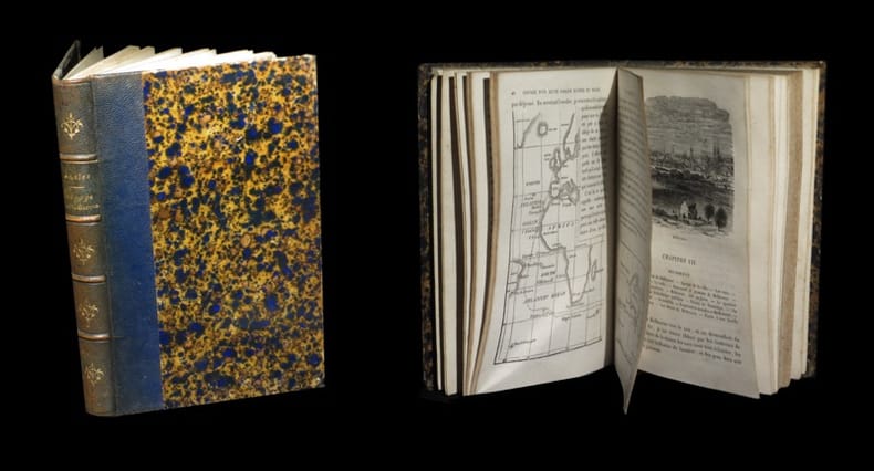
BEAUVOIR (Comte de).
Voyage autour du monde. Australie - Java, Siam, Canton - Pékin, Yeddo, San Francisco.
Plon 1874 3 vol. relié 3 vol. in-12, demi-basane chagrinée havane (reliure d'époque bien conservée), dos à nerfs, 363 pp., 5 cartes (dont une grande), 3 frontispices et 40 gravures par Deschamp.
Ссылка продавца : 97844
|
|
|
WALKER (Betsy), WRIGHT (Jean).
Living in Australia.
San Francisco Chronicle Book 1991 1 vol. relié in-4, cartonnage éditeur, jaquette illustrée, 271 pp., nombreuses photographies en couleurs. Textes et légendes en anglais. Bon état.
Ссылка продавца : 100697
|
|
|
WALKER (Betsy), WRIGHT (Jean).
Living in Australia.
San Francisco Chronicle Book 1991 1 vol. relié in-4, cartonnage éditeur, jaquette illustrée, 271 pp., nombreuses photographies en couleurs. Textes et légendes en anglais. Bon état.
Ссылка продавца : 100697
|
|
|
BATTISTA BALANGERO, GIO.
AUSTRALIA E CEYLAN, studi e recordi di tredici anni di missioneSuivi de :Una gita alla terra santa descrita in 10 lettere
Paravia, Milano, 1897. Un volume in 8° relié percaline noire, décor estampé, reliure éditeur. XVI, 386 pages, un portrait, une carte couleur, nombreuses gravures dans le texte. Couture faible, faux-titre détaché.
Ссылка продавца : 2054
|
|
|
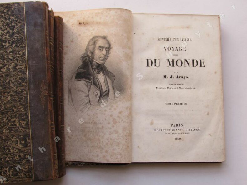
ARAGO, Jacques
SOUVENIRS D'UN AVEUGLE, VOYAGE AUTOUR DU MONDE ; ouvrage enrichi de soixante dessins et de notes scientifiques
1839 Hortet et Ozanne, Paris, 1839. Quatre volumes in 8° reliés demi-basane havane, dos lisses ornés de filets dorés, et d'une roulette à motif floral sur le caisson de queue, plats papier marbré, tranches marbrées. (4), 400, (4), 423, (4), 399, (4), 451 pages. Bien complet de ses soixante planches h-t, dont quatre frontispices. Coiffes supérieures frottées, quelques rousseurs, bon état général. Envoi par colissimo recommandé avec assuraance, 20
Ссылка продавца : 2351
|
|
|
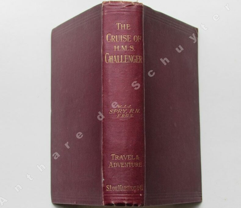
W. J. J. SPRY, R.N., F.R.G.S.
THE CRUISE OF HER MAJESTY'S SHIP "CHALLENGER". Voyages over many seas, scenes in many lands. With maps and illustrations.
1897 Sampson Low, Marston and Company, London, 1897. Un volume in 12° relié percaline lie de vin de l'éditeur, titre doré, 319 pages, une carte dépliante, un frontispice photo, nombreuses gravures dans le texte. Bon état. Poids avant emballage 600 gr, frais d'envoi colissimo 8 . Contrairement à ce ui est vendu sur certains sites dont je tairai le nom par pudeur cet ouvrage n'est pas un paquet de photocopies expédiées eepuis l'Inde !
Ссылка продавца : 3179
|
|
|
John Abbot, Barbara Bayton, Edward Dyson, Roderic Quinn, Henry Lawson, Katherine S. Pritchard, John Le Gay Brereton, Ernest Favenc, Handolf Berdfort, Gilbert M. Turnbull, Vance Palmer, Marriott Watson, Ethel Turner, Henry Green, Louis Becke, Gypsy Kelly
NOUVELLES AUSTRALIENNES, choisies par George Mackaness, traduites de l'anglais par Maurice Rémon.
Paris Albin Michel 1930 1 12° Broché 310 Albin Michel , Paris, 1930. Un volume in 12° broché de 310 pages, bon état. Poids avant emballage 250 gr, frais d'envoi colissimo 650
Ссылка продавца : 3469

|
|
|
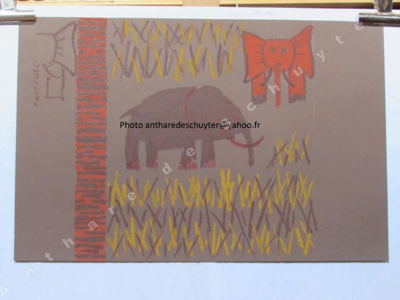
Anonyme, Arts appliqués
DESSIN TEXTILE ORIGINAL STYLE "ETHNIQUE", Réf 4339
Dessin au pastel gras sur papier.Dimensions 500 x 328 mm, bon état. Venez consulter l'ensemble de mes objets sur mon site antharedeschuyter.fr ! Envoi recommandé R2 : 9
Ссылка продавца : 4339
|
|
|
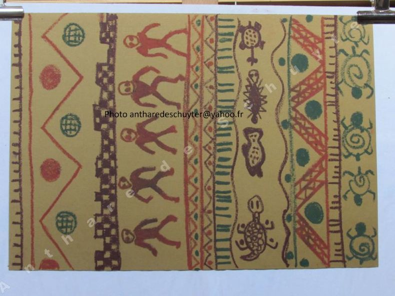
Anonyme, Arts appliqués
DESSIN TEXTILE ORIGINAL STYLE "ETHNIQUE", Réf 4340
Dessin au pastel gras sur papier.Dimensions 500 x 350 mm, bon état. Venez consulter l'ensemble de mes objets sur mon site antharedeschuyter.fr ! Envoi recommandé R2 : 9
Ссылка продавца : 4340
|
|
|
Anonyme, Arts appliqués
DESSIN TEXTILE ORIGINAL STYLE "ART ETHNIQUE", Réf 4344
Dessin à la gouache sur papier.Dimensions 320 x 320 mm, bon état. Venez consulter l'ensemble de mes objets sur mon site antharedeschuyter.fr ! Envoi recommandé R2 : 9
Ссылка продавца : 4344

|
|
|
BEAUVOIR (Le Comte de ).-
Australie. Voyage autour du monde. 5e édition.
Paris, Plon, 1871, in 12, relié demi chagrin vert bouteille, dos à nerf très orné, tête dorée, 364 pages
Ссылка продавца : 6586
|
|
|
FRASER (John Foster).-
L'Australie, comment se fait une nation. Adapté de l'anglais par Georges Feuilloy. 20 photogravures hors-texte et une carte. 4e édition.
1916 P., Pierre Roger (Collection "Les Pays Modernes"), 1916, in 8° broché, 255 pages ; couverture illustrée.
Ссылка продавца : 10854
|
|
|
WEST (Morris).-
L'ambassadeur.
P., Plon, 1965, in 8° cartonnage de léditeur, jaquette illustrée, 306 pages.
Ссылка продавца : 16481
|
|
|
BOLDREWOOD (Rolf).-
The squatter's dream. A story of Australian Life.
London, Mac Millan, 1896, in 8° reliure toile rouge deléditeur, 312 pages, cachets.
Ссылка продавца : 16546
|
|
|
MIELCHE (Hakon).-
Australie. Terre d'avenir et d'aventure. Photos et illustrations de l'auteur.
P., Presses de la Cité, 1957, in 8°, cartonnage éditeur, jaquette illustrée en couleurs, 308 pages.
Ссылка продавца : 17401
|
|
|
JACOBS (Alfred).-
L'Océanie nouvelle. Les chinois et les européens. Migrations des peuples. Contact des races. Caractères nouveaux. De la colonisation au XIXe siècle.
P., M. Lévy, 1861, in 12 relié d'une modeste demi-toile noire amateur, 330pp. ; rousseurs ; reliure très abimée.
Ссылка продавца : 20384
|
|
|
CASTELLA (Hubert de).-
Les squatters australiens.
P., Hachette, 1861, in 12 relié d'une modeste demi-toile noire amateur, 300pp. ; rousseurs, large mouillure angulaire aux 80 premières pages
Ссылка продавца : 20412
|
|
|
BEAUVOIR (Comte de).-
AUSTRALIE. Voyage autour du monde.
1869 Paris, Plon, 1870, fort in 12 broché, IV-364 pages.
Ссылка продавца : 20425
|
|
|
DANIELSSON (Bengt).-
Expédition Boumerang. Traduit du suédois par Marguerite Gay et Gerd de Mautort.
P., Albin Michel, 1960, in 8° broché, 309 pages ; jaquette illustrée ; illustrations hors-texte ; lexique in-fine.
Ссылка продавца : 24778
|
|
|
VARIGNY (C. de).-
Voyage du Matelot Jean-Paul an Australie, suivi de Cornelius Vanderbilt, le roi des bateaux à vapeur - La journée de Victor - Le Petit Homme - Mon parapluie. Ouvrage illustré de 46 gravures. Cinquième édition.
P., A. Colin (Bibliothèque du Petit Français), 1909, in 12 broché, 255pp. ; qq. rares rousseurs éparses.
Ссылка продавца : 29057
|
|
|
GALLOY (Robert).-
Terre de Van Diemen.
Bruxelles, Editions de la Toison d'Or, 1944, in 8° broché, 240 pages (non coupé) ; bande annonce.
Ссылка продавца : 30505
|
|
|
WEST (Morris).-
Toute la vérité. Roman traduit de l'anglais par Jacques Papy.
P., Plon (Collection "Feux Croisés"), 1963, in 8°, cartonnage de l'éditeur, 266 pages ; jaquette illustrée en couleurs ; 2 pages un peu brunies, sinon bel exemplaire.
Ссылка продавца : 31319
|
|
|
WEST (Morris).-
Toute la vérité. Roman traduit de l'anglais par Jacques Papy.
P., Plon, 1957, in 8° broché, V-266 pages.
Ссылка продавца : 42393
|
|
|
WEST (Morris L.).-
La salamandre.
P., Fayard, 1973, in 8° broché, 420 pages.
Ссылка продавца : 44052
|
|
|
MONTEGUT (Emile).-
L'Angleterre et ses colonies australes.
[P., Hachette, 1880], in 12 relié demi-chagrin vert, dos à faux nerfs très orné, 304pp. ; les pages de garde, le faux-titre et le titre manquent ; petites salissures à qq. pp. Exemplaire de travail.
Ссылка продавца : 31840
|
|
|
[AUSTRALIE] - VILLEMINOT (Jacques et Betty).-
Australie. La grande barrière de corail.
P., Presses de la Cité, 1983, in 4° cartonnage illustré de léditeur, 124 pages ; abondamment illustré.
Ссылка продавца : 47612
|
|
|
LEROY-BEAULIEU (Pierre).-
Les nouvelles sociétés anglo-saxonnes. Australie - Nouvelle Zélande - Afrique du Sud. Nouvelle Edition (3ème) entièrement refondue.
P., Colin, 1907, in 12 relié pleine toile noire, XX-487 pages ; cachets et étiquettes de bibliothèque.
Ссылка продавца : 58400
|
|
|
VERSCHUUR (G.).-
Aux Antipodes. Voyages en Australie, à la Nouvelle-Zélande, aux Fidji, à la Nouvelle-Calédonie, aux Nouvelles-Hébrides et dans l'Amérique du Sud. 1888-1889. Ouvrage contenant 50 gravures sur bois.
P., Hachette, 1891, fort in 12 relié demi-basane verte, dos orné de filets dorés, 497 pages ; quelques petites salissures marginales ; cachets ; reliure frottée.
Ссылка продавца : 65833
|
|
|
MACDONNELL (J. E.).-
Les éperviers de la mer (Wings off the sea). Traduit de l'anglais par L. P. Helcet. Préface de Pierre Clostermann.
1957 P., Flammarion (Collection "L'Aventure Vécue"), 1957, in 8° broché, 249 pages ; jaquette illustrée en coulerus.
Ссылка продавца : 71988
|
|
|
LEVY-BRUHL (Lucien).-
La mythologie primitive. Le monde mythique des Australiens et des Papous. 6e édition.
1936 paris, Alcan, 1936, in 8° broché, XLVII-335 pages ; 4 planches hors-texte.
Ссылка продавца : 83901
|
|
|
[Album Mariani] WARD Herbert
Portrait et notice biographique sur: Herbert WARD - Sculpteur et explorateur - né à Londres en 1863 -
Paris - Album Mariani - vers 1900 - 3 pages in8 comprenant une notice biographique de 2 pages, un portrait gravé et un fac-similé d'autographe -
Ссылка продавца : GF24126
|
|
|
SCIZE Pierre - (Michel-Joseph Piot dit) - Pont-de-Chéruy 1894 - Melbourne 1956 - Journaliste et écrivain français
Manuscrit autographe signé: "Madame Colette" -
9 pages in8 - quelques ratures et corrections - Quelques petits accrocs marginaux sans manque de texte -
Ссылка продавца : GF24288
|
|
|
Mary WEBB - [Australie 1901 - France 1958] - Peintre abstraite australienne
Lettre autographe signée à "Chère Madame" [Mme Bosch] - Paris le 29 mai ? - en français -
1 page in8 - bon état -
Ссылка продавца : 33756
|
|
|
Mary WEBB - [Australie 1901 - France 1958] - Peintre abstraite australienne
Lettre autographe signée à "Chère Madame Bosch" - Paris le 3 juillet 1956 - en français -
1 page in8 - bon état -
Ссылка продавца : 33757
|
|
|
Gustav-Adolf MOSSA - [Nice 1883 - 1971] - Peintre symboliste français
Lettre autographe signée à son éditeur Ferroud - Nice le 24 février 1931 -
Carte postale à en tête du Musée Chéret - trés bon état -
Ссылка продавца : 33758
|
|
|
Gustav-Adolf MOSSA - [Nice 1883 - 1971] - Peintre symboliste français
Lettre autographe signée à son éditeur Ferroud - Nice le 1er octobre 1935 -
Carte postale à en tête du Musée Chéret - trés bon état -
Ссылка продавца : 33759
|
|
|
Gustav-Adolf MOSSA - [Nice 1883 - 1971] - Peintre symboliste français
Lettre autographe signée à madame Ferroud - Nice le 8 mai 1939 -
Carte postale à en tête du Musée Chéret - trés bon état -
Ссылка продавца : 33760
|
|
|
Gustav-Adolf MOSSA - [Nice 1883 - 1971] - Peintre symboliste français
Lettre autographe signée à son éditeur Ferroud - Nice le 7 juillet 1924 -
1 page in8 - trés bon état -
Ссылка продавца : 33761
|
|
|
Gustav-Adolf MOSSA - [Nice 1883 - 1971] - Peintre symboliste français
Lettre autographe signée à son éditeur Ferroud - Nice le 1er décembre 1920 -
1 page in12 - trés bon état - adresse au dos -
Ссылка продавца : 33762
|
|
|
Gustav-Adolf MOSSA - [Nice 1883 - 1971] - Peintre symboliste français
Lettre autographe signée à son éditeur Ferroud - Nice le 12 mars 1925 -
1 page in8 - trés bon état -
Ссылка продавца : 33763
|
|
|
Gustav-Adolf MOSSA - [Nice 1883 - 1971] - Peintre symboliste français
Lettre autographe signée à son éditeur Ferroud - Nice le 13 juin 1919 -
1 page in8 - trés bon état -
Ссылка продавца : 33764
|
|
|
Gustav-Adolf MOSSA - [Nice 1883 - 1971] - Peintre symboliste français
Lettre autographe signée à son éditeur Ferroud - Nice le 26 décembre 1934 -
2 pages in8 - trés bon état malgré un petit accroc avec petit manque de papier en marge basse - En tête: Palais des Arts - Musée Jules Chéret -
Ссылка продавца : 33765
|
|
|
Gustav-Adolf MOSSA - [Nice 1883 - 1971] - Peintre symboliste français
Lettre autographe signée à son éditeur Ferroud - Nice le 7 novembre 1925 -
1 page 1/2 in8 - trés bon état - petite salissure en marge basse -
Ссылка продавца : 33766
|
|
|
Hugues-Jean de DIANOUS de la PERROTINE - [Lyon 1914 - Fremant (Australie) 2008] - Linguiste et diplomate français
Lettre autographe signée à "cher Monsieur" - Nairobi le 18 aout 1972 -
2 pages in4 - trés bon état - En tête: Ambassade de France au Kenya -
Ссылка продавца : 35130
|
|
|
SMILES (Samuel).
Voyage d'un jeune garçon autour du monde.
Paris, E. Plon et Cie, 1876. Un vol. au format in-12 (188 x 123 mm) de 2 ff. n.fol. et 285 pp. Reliure de l'époque de demi-chagrin marine, dos à nerfs orné de filets gras en noir, larges fleurons dorés, pièce de titre de maroquin émeraude, titre doré, tranches mouchetées. (Mespoulède).
Ссылка продавца : 27275
|
|
|
MANGIN (Arthur).
Voyages et découvertes outre-mer au XIXème siècle.
Tours, Alfred Mame et Fils, 1883. Un fort vol. au format in-4 (298 x 197 mm) de 400 pp. Reliure d'édition de plein cartonnage cerise, plats orné d'un important décor comportant filets d'encadrement fleurons et semis d'étoiles en noir, large décor fleuronné doré, titre frappé or au centre d'un cartouche, dos lisse orné d'un caisson d'encadrement doré, larges fleurons dorés, filets dorés en tête et queue, titre doré, tranches dorées.
Ссылка продавца : 30353

|
|
|
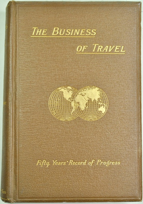
FRASER RAE (W.).
The Business of Travel. A fifty years' record of progress. 1841- Leicester to Loughborough (12 miles). 1891- All over the globe.
London, Thos. Cook and son, 1891. In-8 de (1à)-318 pp., cartonnage de l'éditeur.
Ссылка продавца : 166
|
|
|
MIGNET (François-Auguste).
Antonio Perez et Philippe II.
Paris, Didier et Cie, 1874. In-8 de (4)-VIII-441 pp., demi-chagrin brun, dos à nerfs (reliure de l'époque).
Ссылка продавца : 1324
|
|
 Получить результаты поиска по электронной почте
 Загрузить результаты в формате PDF
  RSS-канал


