|
[AUSTRALIE] - SIMPSON (Colin) -
Primitifs d'australie ADAM D'OCRE PARÉ.
Paris, Société continentale d'éditions moderne illustrées - connaissance des iles - , 1966; grand in-8, 366 pp., cartonnage de l'éditeur. Traduction de L.M. Ravet - 64 planches hors texte en héliogravure, 8 planches hors texte en couleur, 28 cartes et croquis dans le texte -hors commerce pour les biblliophiles de l'aventure - très bon état avec son rhodoide.
书商的参考编号 : 201212575
|
|
|
[AUSTRALIE] - MC KINNEY (Kenneth), ROSSI (Guido alberto ) -
Australie.
, Booking international, 1996; in-4, 287 pp., cartonnage de l'éditeur. Avec jaquette.
书商的参考编号 : 201113881
|
|
|
[AUSTRALIE] - COLLECTIF -
Le grand guide de l'australie.
Paris, Gallimard bibliothèque du voyageur, 1996; in-8, 369 pp., broché, couverture illustr. Bon état.
书商的参考编号 : 201014762
|
|
|
[AUSTRALIE ] - GSELL (F x ) -
L evêque aux 150 épouses.
Paris, La colombe , 1954; in 8, 138 pp., broché, couverture illustr. Cinquante années de vie missionnaires en australie introduction par andré dupeyrat.
书商的参考编号 : 200905189
|
|
|
[AUSTRALIE] - SIMPSON (Colin) -
Primitifs d'australie ADAM D'OCRE PARÉ.
Paris, Société continentale d'éditions moderne illustrées - connaissance des iles - , 1966; grand in-8, 366 pp., cartonnage de l'éditeur. Traduction de L.M. Ravet - 64 planches hors texte en héliogravure, 8 planches hors texte en couleur, 28 cartes et croquis dans le texte -hors commerce pour les biblliophiles de l'aventure.
书商的参考编号 : 200813766
|
|
|
[AUSTRALIE]
Australie.
Paris, Editions FL larousse, 1996; in-8, 121 pp., cartonnage de l'éditeur.
书商的参考编号 : 200809434
|
|
|
[AUSTRALIE] - VILLMINOT (Jacquess et paule) -
Australie terre de fortune.
Paris, Robert Laffont, 1974; in-8, 347 pp., broché, couverture illustr.
书商的参考编号 : 200615682
|
|
|
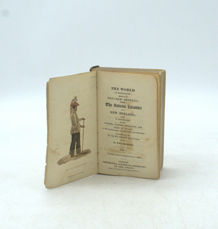
SHOBERL, Frederic
The Asiatic Islands and New Holland : being a description of the manners, customs, character, and state of society of the various tribes by which they are inhabites.
London : R. Ackermann, 1824, 2 volumes in one in-12 (135x75mm), 2ff.-VII—1f.-291pp.-1f.-289pp., sans reliure, illustré de 21 (26) planches en couleurs.
书商的参考编号 : PHO-1993
|
|
|
*
LA NOUVELLE-GALLES DU SUD. "LA COLONIE MERE DES AUSTRALIES ".
Sydney 1896, petit in 4 toile verte décorée éd, XIV-337pp, 24 ill hors texte gravures et photos, 7 cartes et diagrame Publié par le gouvernement. Ouvrage fort complet. Ex dono du gouvernement. Quelques traces d'humidité du la couverture. Intérieur très frais
书商的参考编号 : ML256
|
|
|
FAUCHERY Antoine
LETTRES D'UN MINEUR EN AUSTRALIE PRÉCÉDÉES D'UNE LETTRE DE THÉODORE DE BANVILLE
1859 P, Poulet-malassis et De Broise , 1859 , in8br , XXIII - 278 pp Couverture défraichie , intérieur frais avec quelques pâles rousseurs.
书商的参考编号 : M10619
|
|
|
L ' AUSTRALIE . Découverte - Colonisation - Civilisation . 3 ème édition revue et corrigée.
1861 Tours , Mame , 1861 , in8 1/2 toile verte , 236 pp , 1 gravure frontispice, cachetes ex biliothèque, un léger manque sur une page de garde
书商的参考编号 : M12016
|
|
|
PASQUIER H
Notes d'un Voyage autour du Monde. Les Indes, Ceylan, l'Australie, la Nouvelle Zélande, les Etats-Unis. Illustrations d' E gaillot d' après les documents de l' auteur.
Angers , Siraudeau , 1906 , petit in4° br , 458pp , non coupé . Langue: Français
书商的参考编号 : M12722
|
|
|
BECKE Louis
WILD LIFE IN SOUTHERN SEAS . Secon edition .
1897 Couverture rigide 1897 London , Fisher unwin , 1897 , in8 percaline grise illustrée éditeur , 369 pp . Exemplaire en bon état édité sur papier de qualité . Louis Becke( 1855 - 1913 ) est un aventurier australien qui fur aussin écrivain . C' est Monfreid avant l' heure . Dans la lignée des Stevenson et autres Conrad . Langue: Français
书商的参考编号 : M18489
|
|
|
VILLIERS Alan
LA TASMANIE AU TEMPS DES BALEINIERS ET DES FORCATS.
1978 France Empire Couverture souple 1978 France Empire, 1978 , in8 broché, 316 pp . Illustrations hors texte .
书商的参考编号 : M162498
|
|
|
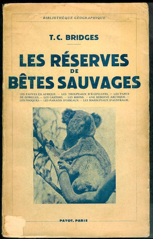
BRIDGES (T.C.).
Les réserves de bêtes sauvages.
P., Payot, 1938, 1 vol. in-8 br. de 264 pp. couverture très légèrement défraîchies, bel exemplaire par ailleurs.
书商的参考编号 : 347
|
|
|
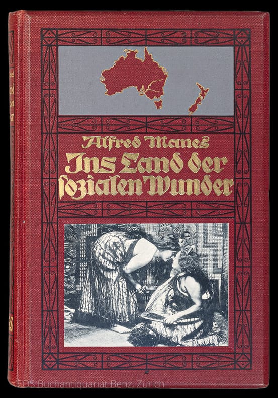
Manes, Alfred:
Ins Land der sozialen Wunder. Eine Studienfahrt durch Japan und die Südsee nach Australien und Neuseeland.
2. unveränderte Auflage. Berlin, Ernst Siegfried Mittler und Sohn, 1912. 8°. XII, 312 S. Mit Tafeln und Illustr. im Text. Illustr. Orig.-Leinenband.
书商的参考编号 : 1489BB
|
|
|
Panoramic Sidney.
Sydney, N.S.W. Bookstall, (around 1900). Quer-4°. (24) p. With 19 panoramic photographs (thereof 4 double page). Orig. wrappers (bumped, slightly waterstained and with some tears).
书商的参考编号 : 28802AB
|
|
|
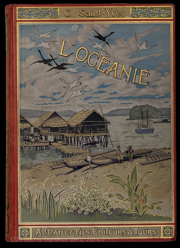
Saint-Yves, Georges:
L'Océanie.
Tours, A. Mame et fils, (1902). Gr. in-8°. 398 S. Mit 18 Tafeln (davon 2 Karten). Farb. illustr. Orig.-Leinenband.
书商的参考编号 : 7486CB
|
|
|
Sievers, Wilhelm:
Australien und Ozeanien.
Leipzig u. Wien, Bibliographisches Institut, 1895. 8°. VIII, 521 S. Mit einer Porträt-Tafel, 12 farb. Karten (davon 7 doppelblattgrosse) und 19 Tafeln (davon 8 chormolithogr.). Halblederband der Zeit.
书商的参考编号 : 11042AB
|
|
|
Wood, Jones Frederic;
Coral and Atolls. their history, description, theories of their origin both before and since that of Darwin, the influence of winds, tides and ocean currents on their formation and transformations, their present condition, products, fauna and flora.
London, Reeve, 1912. 8°. XXIII, 392 S. Mit zahlr. Karten, Tafeln und Abb. Orig.-Leinenband.
书商的参考编号 : 7485CB
|
|
|
Aboriginal Arts. Austellung vom 22. September bis 23. Oktober 1989.
Kreuzlingen, Signer International, 1989 72 Seiten. Mit zahlreichen Abbildungen, davon 26 meist ganzseitige farbig. Orig.-Broschur.
书商的参考编号 : 21762AB
|
|
|
Jacobs, Alfred
L'Océanie nouvelle : les Chinois et les Européens, Migration des peuples, Contact des races, Caractères nouveaux, De la colonisation au XIXe siècle
1861 Paris, Michel Lévy frères, 1861. 18 x 11,5 cm, in-12°, 330 pp., reliure de l'époque en demi chagrin bleu, dos lisse estampé et doré.
书商的参考编号 : 563

|
|
|
LECLERC (Ch.).
Bibliothèques de MM. l'abbé FAVRE, Léon PAGES et Dr. MOURIER.
Paris, Maisonneuve et Larose, 1974 (reprint des éditions de 1888 et 1889). In-8, 68 pp. et 100 pp., cartonnage toile de l'éditeur.
书商的参考编号 : B305
|
|
|
Ellenberger Victor - [Australie]
LA FIN TRAGIQUE DES BUSHMEN. Les derniers hommes vivants de l'âge de la pierre
1953 Paris Amiot Dumont 1953 Un volume in°8 broché sous jaquette 264 pages Photographies hors-texte A11
书商的参考编号 : 2034

|
|
|
CARRIER Jean-Pierre - [Australie]
L'étrange continent
Paris Editions du Scorpion 1956 Un volume in°12 broché 222 pages. Photographies hors-texte A12
书商的参考编号 : 2199

|
|
|
RICHEY, Marjorie (introd.).
RECENT CERAMICS. AN EXHIBITION FROM AUSTRALIA.
Sydney, Crafts Board Australia Council, 1981 Paperback, original editor's jacket, 26.6x21 cm., 72 pp., illustrations in colour and in b/w, bilingual edition English/German. ISBN 0908024282.
书商的参考编号 : 33363
|
|
|
Sabine Grabner and Agnes Husslein-Arco
Orient and Occident, Travelling 19th century austrian painters.
DE, Hirmer verlag, 2012 hardcover, 264 pages, 125 colour plates and 70 illustrations, 19 in black and white , 23 x 28,5 cm, hardcover. fine condition !! . ISBN 9783777458915.
书商的参考编号 : 42972
|
|
|
BEAUVOIR Comte de.
Australie. Voyage autour du Monde. Ouvrage enrichi de cartes et de photographies.
Paris, Plon, 1872. In-12 demi-basane tabac X-363 pages, 12 planches en noir et 2 cartes depliantes en couleurs,dont une abimee.
书商的参考编号 : 2357b
|
|
|
Spence, W. G
Australia's Awakening. Thirty Years in the Life of an Australian Agitator
Brisbane 1942. 8vo. (520pp. ). With portr., and 17 full-page plates.,pleine toile ,dos imprimé collé au dos lisse
书商的参考编号 : 2875
|
|
|
L., H. A. [Henry Astbury Leveson.] "The Old Shekarry."
Sport in Many Lands. Europe, Asia, Africa and America. Etc., Etc. With one hundred and eighty illustrations.
London and New York. Frederick Warne and Co. 1890. - Hardcover. No dust-wrapper. xlvi, [2], 587, [1], [4] ad's pages. Illustrated throughout with engravings. Original pictorial red cloth, gilt. All edges gilt. Head of spine expertly strengthened; prize label on endpaper; else a very good copy.
书商的参考编号 : 2954
|
|
|
Hundertwasser
Hundertwasser: 1973 New Zealand (and Australia)
1973 Glarus (Switzerland): Gruener Janura, 1973 Cloth w/ Pictorial Pastedown. As New/No Jacket, as Issued. First Edition. 16mo - Catalgue, hardbound black cloth w/ color pictorial pastedown, published on thr event of the Hundertwasser Exhibition in New Zealnd and Australia 1973 - 1974. 97p. Biographical notes. Architectural notes by Don Henry Fulton and essay by Wieland Schmied. 24 color plates - brilliantly reproduced and tipped-in on black paper. Author photo in b&w rear pastedown. A handosme production.
书商的参考编号 : 3999

|
|
|
BERNATZIK (Adolphe)
Canaques et papous. Traduit de l'allemand par Henri Daussy.
Paris, Société Nouvelle des Editions SELF, 1952 In-8 broché sous jaquette illustrée, 250 pp. cartes + photos tirées en héliogravure:2 cartes itinéraires(Nouvelle Guinée - Papouasie - Australie) et 32 planches hors-texte de photographies. Les Iles Salomon, la Nouvelle-Guinée et Bali
书商的参考编号 : 10804
|
|
|
Sydney
Sydney N.S.W.. The Gem of the South.
Album Oblong 4to; pp. 36; 6 pages colour plates, 30 pages b/w plates (some full page), no text; illustrated wrapper, a good copy. (Willoughby, N.S.W., H.Phillips), N.d. (c. 1920)
书商的参考编号 : 11235

|
|
|
FRASER J.F. -
L'Australie. Comment se fait une Nation, adapté de l'anglais par Georges FEUILLOY -
Pierre Roger 1916, in-8 , broché, 255 pages avec 20 planches hors-texte et une carte in-fine.
书商的参考编号 : 12313
|
|
|
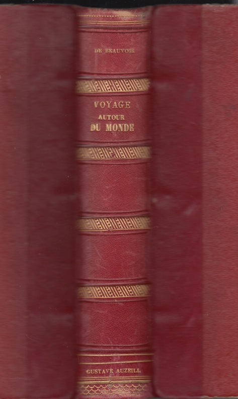
BEAUVOIR Comte de.
Australie. Voyage autour du Monde. Ouvrage enrichi de cartes et de photographies.
Paris, Plon, 1870. In-12,broché, X-363 pages, 12 planches en noir et 2 cartes depliantes en couleurs.
书商的参考编号 : 14677
|
|
|
HUTCHINGSON, Frank.Villeval, M. Albin [Translator]:COLLECTIF
La Nouvelle-Galles Du Sud, la Colonie-Mere Des Australies
1896 Sydney: Charles Potter, 1896 - Pleine Percaline rouge editeur. Bon etat Général hormis qques rousseurs. GRAND In-8. XIV+337 pp, traduit de l'anglais par M. Albin Villeval. Articles de H.C. Russel, Pitt Cobbett, Harris A.G. Curry, R.L.Nash, W.G.Randall, Henry W. Wright, Fred. Turner, etc. Frontispice. 2 cartes dépliantes ( un plan et une carte couleur ) in-fine, une vue panoramique en couleur dépliante en début de volume, nombreuses illustrations N&B hors-texte, tableaux et graphiques. 1er plat et dos estampés à chaud, Offert par le gouvernement de la Nouvelle-Galles du sud; Photo et description sur demande.Picture and description upon request.First edition. Publisher’s lavish pictorial gilt tan bevelled cloth. Profusely illustrated with scores of photographic illustrations of all aspects of the Colony’s life, history, commerce, industry, public buildings, etc. Also a 3’ Panoramic View of Sydney and Harbour from the North Shore, a 30” x 27” Map of N.S.W Railways and a 20” x 30” plan of Sydney. Ferguson, Bibliography of Australia, VI, 10713.
书商的参考编号 : 15369

|
|
|
LEVY-BRUHL Lucien
LA MYTHOLOGIE PRIMITIVE. Le monde mythique des Australiens et des Papous
Félix Alcan, PARIS 1936,broche, Softcover 336 pages.Bibliothèque de philosophie contemporaine. Travaux de l" année sociologique publiés sous la direction de M. Marcel Mauss. 4 planches hors-texte.
书商的参考编号 : 17189
|
|
|
OCHSE Julien
D'île en île.
Mercure de France. 1912 -IN12 Broché. 246 pages. exemplaire du Service de Presse,numerote sur velin
书商的参考编号 : 19941
|
|
|
BEAUVOIR (Comte de).
Voyage autour du monde. Australie, Java, Siam, Canton, Pékin, Yeddo, San Francisco.
Paris, Henri Plon, Imprimeur-editeur, sans date (1870 ?) - Gd in-8° ; faux titre-titre gravé illustré-page de gd titre.- 880 pp.-texte a 2 colonnes ,nombreuses gravures sur bois in et hors texte dos à nerfs en demi-chagrin rouge, rel. de l'époque, bel exemplaire de l’edition originale ?
书商的参考编号 : 20212
|
|
|
BRASSEY LADY
Aux Indes et en Australie dans le Yacht le "Sunbeam".Ouvrage traduit de l'anglais par Gaston Bonnefont. Illustré de 200 dessins de R.T. Pritchett, gravés sur bois par E. Whymper, J.D. Cooper et G. Pearson.
1893 MAME Alfred et Fils. 1893. In-4 cartonnage toilé rouge defraichi un peu usé. Intérieur un peu defraichi,rousseurs eparses. 398 pages. Frontispice en noir et blanc. Nombreuses illustrations en noir et blanc dans le texte et hors-texte.
书商的参考编号 : 20266

|
|
|
N/A AUSTRALIE
Adelaide Illustrated. Inner Title: A Photographic Souvenir of Adelaide:
Adelaide: Robert A. Thompson & Co./Melbourne: Robert Jolley: n.d. [c. 1900]] Osboldstone & Atkins, Printers, Melbourne. Photos by SJ Dailey, Adelaide. Dec. wrs plus pp. 24 of captioned views, printed on art paper (185 x 250mm) Cover Title: Adelaide Illustrated. Inner Title: A Photographic Souvenir of Adelaide: Containing 44 Views of the principal Streets, Buildings, &c. Near mint condition. Rare
书商的参考编号 : 21346
|
|
|
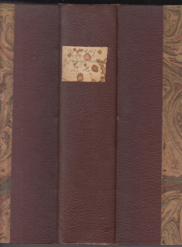
Arago Jacques
Voyage autour du monde par Jacques Arago nouvelle edition revue et augmentee Illustree de 61 Belles Estampes et Enrichie de Notes Scientifiques.Souvenirs d'un aveugle.
1840 Bruxelles, Société Typographique Belge, Ad. Wahlen et Compagnie, 1840,Brussels, Societe Typographique, 1840.fort IN8; 570p.,reliure pleine toile à coins posterieure, texte à 2 colonnes ,numeration des planches en desordre?;60 sujets en lithographie en noir,traces de mouillure en coin de quelques feuillets .Large octavo, with a portrait frontispiece & 60 lithographic illustrations, The popular account of Louis de Freycinet's circumnavigation in the Uranie from the pen of the official artist on the voyage. The voyage touched on the Canary Islands, Rio de Janeiro, Ile de France & Bourbon, Timor, Indonesia, the Marianas & Caroline Islands, Hawaii (13 chapters), Australia (8 chapters), and the Malouines. The plates, taken from drawings by Arago on the voyage, are largely portraits of aborigines encountered around the world, and there is extensive reference to the comparative customs of the peoples. Despite the fact that six editions are recorded in Ferguson, this one is not.(although a four-volume version of the same year is Ferguson 2906). Ferguson, 2906b; Forbes, 'Hawaiian National Bibliography', 1191.
书商的参考编号 : 22174
|
|
|
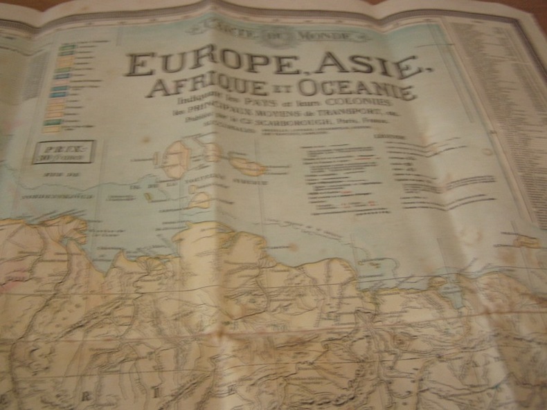
SCARBOROUG COMPAGNY Paris
Carte du monde bi face Amerique nord sud et Europe Afrique,Asie, Australie texte en français -Large Map CHART OF THE WORLD STEAMER ROUTES
1910 Antique Double Sided World Map by The Scarborough Company c1910 Grande carte toilée double face pliée sous étui avec itineraires et distances.This map has Europe, Asia, Africa & Australia on one side and North America & South America on the other and was published by the Scarborough Company, London, England, around 1910 (latest copyright date) but was printed in Boston, Mass, USA and was originally priced at 15 shillings (£0.75)- quite a sum at that time - equivalent to about £80 now. It includes principal ocean steamship lines, distances in nautical miles along steamship routes andthe routes shown in red on the map, principal places etc. It measures 39 inches wide by 41 inches high (100 x 104 cm) and is printedon cloth. It's in reasonable condition for its age - a bit of foxing, a couple of other marks and some slight frayingbut no splits or tears- see pictures - they form part of the description.
书商的参考编号 : 22861
|
|
|
Jacques Chiquet Le Nouveau et Curieux Atlas Geographique et Historique.
L' Asie Dressée selon les Observations de Mrs. de l'Academie Royale des Sciences. Carte gravée d'époque coloris époque avec feuillet de texte imprimé joint,extrait du Nouveau et Curieux Atlas Geographique et Historique.
1719 A Paris chez I. Chiquet A Paris 1719. - 25':.- Altkolorierter Kupferstich aus Le nouveau et curieux Atlas Geographique . b. Jacques Chiquet in Paris, dat. 1719, 17 x 22,5cm Tooley's Dic. of Mapm. Rev. Ed. A - D, S. 264 (Jacques Chiquet, c. 1673-1721; french cartographer, engraver and 'marchand d' estampes, rue St Jacques' in Paris). - Zeigt Asien zwischen Arabien und Japan. - Fine condition, good margins.bonnes marges
书商的参考编号 : 22865

|
|
|
BEAUVOIR (Le Comte de).
Australie. Voyage autour du monde.
1873 Paris, Henri Plon, 1873. In-12°, frontispice, IV, 363 (1) pp., 6 ff.n.ch., demi-chagrin noir, dos à faux nerfs , (Reliure de l'époque). Ouvrage enrichi de deux grandes cartes et de douze gravures-photographies par Deschamps. Huitième édition. Bon état.
书商的参考编号 : 23559

|
|
|
PECH Emile
Un oncle d'Australie
Jouvet & Cie éditeur sans date vers 1890,Grand in 8 pleine toile rouge éditeur à la bradel,bords à biseaux.Beau premier plat orné d'une scène animée polychrome avec titre doré,reliure de Engel, titre et fers dorés en long au dos,286 pages,tranches dorées.73 gravures dans et hors-texte de LIEGER cartonnage ,premier plat historié,une charniere fendillée,dans l'etat..
书商的参考编号 : 24393

|
|
|
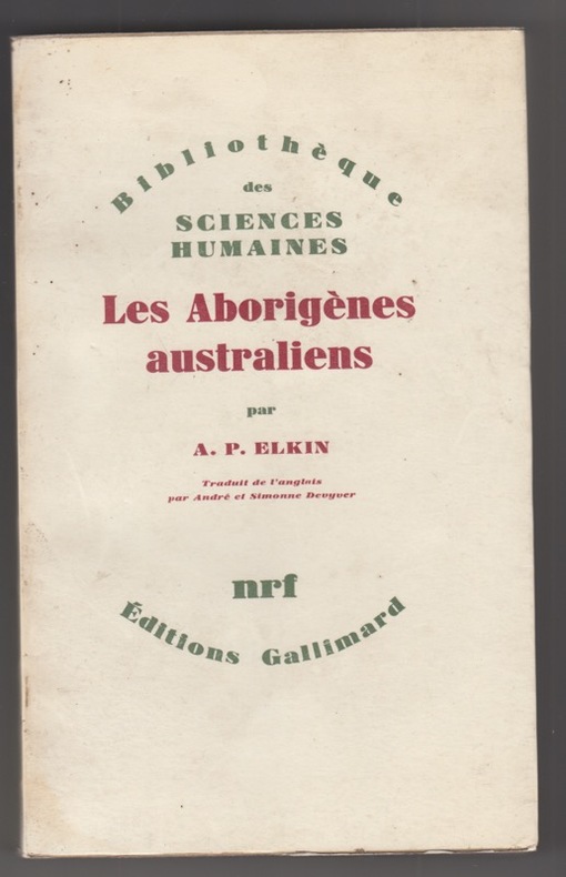
Adolphus P Elkin
Les aborigènes australiens : Trad. de l'anglais par André et Simonne Devyver
1967 Paris : Gallimard, 1967. Bibliothèque des Sciences humaines.in8 broché,453p.+ 32 p. hors texte, 51 ill., 140 x 225 mm,couv.plastifiée leg.defraichies,plis au dos,rare.
书商的参考编号 : 25717
|
|
|
Aubert,
Vue Ville de Sydney en Australie - Gravure ancienne - Eau forte Gravure originale en taille-douce sur acier dessinée par Aubert, gravée par Aubert.
1862 Paris . Dufour , Mulat et Boulanger éditeur / Imprimerie Gilquin et Dupain . Vers 1862 - 27,5 x 18 cm [ 15,5 x 10,5 cm de Gravure ],gravée sur acier par Aubert,
书商的参考编号 : 26238

|
|
|
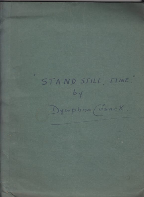
Cusack, Dymphna (1902- 1981)
Stand still time : a play in three acts [Original typescript:].
1946 TAPUSCRIT bicolore, 1946, Broadcast by the Australian Broadcasting Commission under the title 'Eternal Now'; -Plays in typescript, carbon typescript,- 92 ff, leaves, rectos only.; good.
书商的参考编号 : 27208
|
|
|
ABRERA Bernard d'
A field companion to the butterflies of Australia and New Zealand
Victoria The Five Mile Press 1984 in-12, cartonnage éditeur à la Bradel, 176pp. Nombreuses figures en noir et en couleurs.
书商的参考编号 : 016452
|
|
 ?????????
 ?????PDF???
 RSS feed


