|
JOANNE (Adolphe)
Géographie du Nord
Paris, Librairie Hachette, 1904, 60 pp. in-12, rel. carto. édit, dos toilé bleu, ill. h.t 17 grav. et une carte coloriée h.t dépl.
Référence libraire : 3805
|
|
|
JOANNE (Adolphe)
Géographie du Puy-de-Dôme
Paris, Librairie Hachette, 1911, 82 pp. in-12, rel. carto. édit, dos toilé bleu, ill. h.t 21 grav. et une carte coloriée h.t dépl.
Référence libraire : 3813
|
|
|
JOANNE (Adolphe)
Géographie du Tarn-et-Garonne
Paris, Librairie Hachette, 1885, 60 pp. in-12, rel. carto. édit, dos toilé bleu, ill. h.t 8 grav. et une carte coloriée h.t dépl.
Référence libraire : 3802
|
|
|
JOANNE Ad.
Carte du d?partement de la Manche au 1/440 000?. Sans date.
1 feuille sous couverture toil?e d?fra?chie. 25x35 cm.
|
|
|
JOANNE Adolphe
FRANCE NORMANDIE
1886 cart. toil. éd. in-8, 7 cartes repliées / onglet et 4 plans, 580 p., 1886 hachete éd.,
Référence libraire : 717
|
|
|
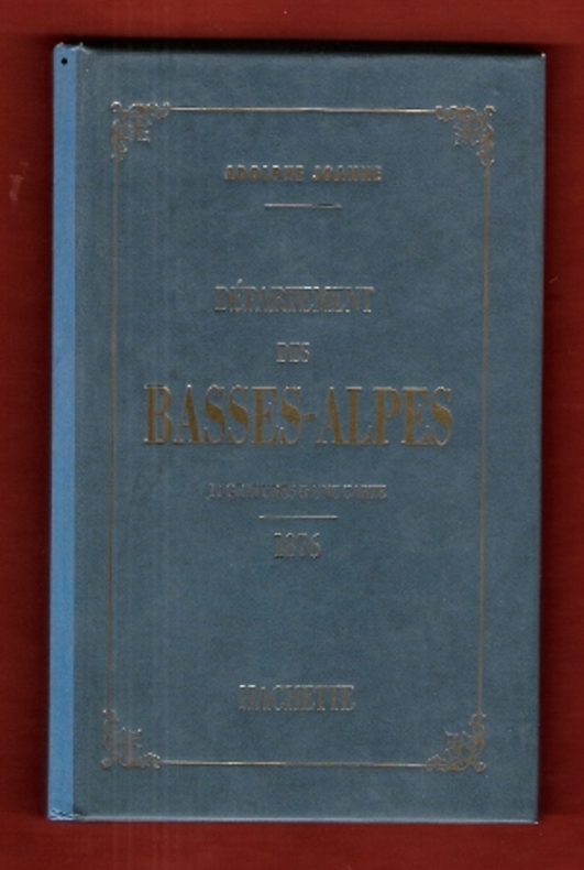
JOANNE Adolphe
Géographie Du Département Des Basses-Alpes . 11 Gravures & Une Carte Coloriée - 1876 . Complet De Sa Carte Dépliante En Couleurs
Paris Hachette 1993 In 12 Très belle iconographie reprenant les gravures des villages de l'époque . Guide Joanne . Cartes et plans . - 50 p. , 300 gr.
Référence libraire : 009987
|
|
|
JOANNE Adolphe
Géographie Du Département Des Basses-Alpes . 11 Gravures & Une Carte Coloriée - 1876 . Complet De Sa Carte Dépliante En Couleurs
Très belle iconographie reprenant les gravures des villages de l'époque . Guide Joanne . Cartes et plans . - 50 p. , 300 gr.

|
|
|
JOANNE Adolphe
Nouveau plan de Paris
- Hachette, Paris 1867, 11x17,8cm, relié. - Collection des guides Joanne. Liste alphabétique des rues de Paris avec également la liste des omnibus et leurs trajets, les prix, les voitures mobiles et autres transports publics. Reliure d'éditeur en pleine percaline violette. Dos lisse muet. Titre et armes de Paris sur le premier plat. Grand plan dépliante de Paris en couleurs. Plusieurs petites déchirures. Bon exemplaire. Le Paris de Napoléon III et de Haussman. Ce plan de Paris a été édité pour l'exposition universelle de Paris de 1867. On lit à la fin du capitre sur les voitures publiques : "Un service spécial, de la place du Palais-Royal au pot d'Iena, aura lieu pendant toute la durée de l'exposition". [ENGLISH DESCRIPTION ON DEMAND]

|
|
|
JOANNE Adolphe:
Les environs de Paris. Illustré. Itinéraire descriptif et historique.
Paris, Lib. de L. Hachette et Cie, [1856]. In-8 de XVI-847 pages, pleine percaline bleue d’éditeur, dos lisse orné de caissons à froid. Coiffes frottées, 1er plat taché, mors du 1er plat fendu en sa partie inférieure (3 cm), quelques rousseurs.
Référence libraire : 2432

|
|
|
JOANNE Paul
Belgique et Grand-Duché De Luxembourg . Complet De Sa Carte Indépendante En Fin D'ouvrage
Collection " Des Guides-Joanne " avec 15 plans et 7 cartes en couleurs dont certaines dépliantes . Nombreuses publicités , notamment d'hôtels mais aussi de Michelin , de chocolat Menier etc .- 312 p. + 118 p. , 550 gr.

|
|
|
JOANNE Paul
DAUPHINE ET SAVOIE 1883
1883 cart. éd. toil. verte in-12, 5 cartes, 2 plans, 3 panoramas, 462 p., 1883 hachette éd.,
Référence libraire : 751
|
|
|
Joanne Paul
Itinéraire général de la France - Bretagne
Hachette et Cie Toile d'éditeur In-12 (11x17.5 cm), reliure toile d'éditeur, auteur, titre et éditeur dorés sur le 1er plat et au dos, 30-(XXXII)-662 pages et 92 pages de publicités des Guides Joanne, cartes dépliantes en couleurs ; ors un peu passés au dos, coiffes un peu frottées, une pastille ronde au dos, certaines pages se détachent du dos, assez bon état. Livraison a domicile (La Poste) ou en Mondial Relay sur simple demande.
Référence libraire : ys167
|
|
|
JOANNE Paul
Itinéraire Général De La France : Corse
Paris Hachette et Cie 1892 In-12 64+LXIII+180+128 pp, cahiers de publicités en début et fin de volume. 4 cartes dépliantes en couleurs et 2 plans. Décors à froid, titre estampé à chaud sur 1er plat et dos. Ensemble légèrement passé, frottis sur coiffes et percaline fendue sur 2 mors.
Référence libraire : 8871
|
|
|
JOANNE Paul:
Itinéraire général de la France. (... ) De la Loire à la Gironde. Poitou et Saintonge.
Paris, Lib. Hachette et Cie, 1889. 1 vol. in-8 de 40, XXVI-259-126 pages, pleine percaline bleue d’éditeur, dos lisse orné à froid, plats encadrés à froid. Un mors fendu (1 cm), minuscules taches à la percaline, cahiers de publicité déboîtés mais solidaires.
Référence libraire : 2433

|
|
|
JOANNE, Adolphe.
Géographie du département de la Nièvre. Avec une carte coloriée et 15 gravures. Neuvième édition.
Paris, Librairie Hachette 1907 183x113mm, 65pages, cartonnage de l’éditeur. Bel exemplaire.
Référence libraire : 63452
|
|
|
JOHANNE (Adolphe)
Géographie des Basses-Pyrénées
Paris, Librairie Hachette, 1894, 76 pp. in-12, rel. carto. édit, dos toilé bleu, ill. h.t 12 grav. et une carte coloriée h.t dépl.
Référence libraire : 3799
|
|
|
John Anderson and Stearns Morse, Illustrated by Black and White Photos,maps
The Book of the White Mountians
New York: Minton Balch & Company 1930 1930. No Binding. Near Fine. Green Cloth Gilt Titles. No Jacket. First. 300 pages <br/> <br/> New York: Minton, Balch & Company, 1930 unknown
Référence libraire : 002520
|
|
|
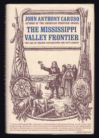
John Anthony Caruso; Neil E. Bolyard (maps)
The Mississippi Valley Frontier: The Age of French Exploration and Settlement
Indianapolis: The Bobbs-Merrill Company Inc. 1966. First edition 1st printing. Hardcover book complete in its original dust jacket unclipped. 24 cm. 423 pp. In very good condition. No ownership marks/writing present within. Tiny number penned to the front inner dust jacket flap. A touch of spotting/soiling to the book block edges. Light edge wear/bumping soiling rubbing to the dust jacket protected under a removable clear mylar sleeve. unknown
Référence libraire : 913
|
|
|
JOHN BARTHOLOMEW & CO.
Lower Egypt.
London.: The Times. 1920. Map printed in colour 47 x 59.5 cm sheet showing cultivated land in green and desert in cream five insets: Port Said Suez Environs of Cairo and two showing continuations of the Nile; original fold two small edge tears but in very good condition. Attractive large map prepared as plate 79 from "The Times Survey Atlas and Gazeteer of the World". . The Times. unknown
Référence libraire : 47836
|
|
|
John Bartholomew
Map of Spain and Portugal in Layer Colouring 1 : 1,600,000. (1943)
Clean map with two panes a little dusty, four inch tear along one fold and small holes to a few folding corners. 1pp. Linen-backed folded contour map dated 1943 opens up to 25 x 31 inches. Scale given on front cover of 1:6,000,000 is corrected inside as being 1:1,600.000. Date 1943 printed on lower map corner. Scarce.
|
|
|
John Bartholomew & Son
Illustrated World Atlas
Bartholomew 1992 176 pages 22 2x3x31 2cm. 1992. Relié. 176 pages.
Référence libraire : 500261917

|
|
|
John Bartlet Brebner; Sidney Butchkes (cover design); John-Paul Tremblay (maps); Joseph P. Ascherl (typography)
The Explorers of North America 1492-1806 -- From Columbus to Lewis and Clark
Garden City N.Y.: Doubleday Anchor Books 1955. Mass Market PaperBack . Fair. Creased spine that has been reglued/repaired so that it is quite firm & solid. Mildly sunned at spine and cover margins parallel spine edge. Damp stained top textblock edge left side. Dust stained edges. Rubber stamped title page: 'Large Print Dunwoody Village' though this is certainly not a Large Print edition. 431 pages. Doubleday Anchor Books paperback
Référence libraire : 246897
|
|
|
John Betjeman
John Betjeman's Oxford
No marks or inscriptions. No creasing to covers or to spine. A very clean very tight copy with bright unmarked boards, slight sunning to spine, signs of storage and no bumping to corners. 192pp. Originally written in the 1930s, an unusual illustrated guide and history to the City of Oxford.

|
|
|
John de Visser
Grand River Reflections
No marks or inscriptions. A lovely clean very tight copy with bright unmarked boards, very slight bumping to lower edge and no bumping to corners. Dust jacket not price clipped or marked or torn or creased. 155pp. A lavish photographic work giving some details of the history of the area from the Dundalk Highlands of Southern Ontario to Port Maitland on Lake Erie, beautifully enhanced by the superb colour images.. Very scarce in the UK.

|
|
|
John Howard Hinton Editor; John Tallis maps Illustrator;
The History and Topography of the United States of America
J & F. Tallis London Edinburg & Dublin 1850-01-01. Leather. Very Good. 1850 Tallis 6 volumes bound into 2 vols 3/4 leather over marbleized boards. 7 hand colored maps 56 plates ownership ink to flyleafs and book dealership pencil. Tight bindings text unmarked. oversized and overweight. Please email for photos. J & F. Tallis, London, Edinburg & Dublin hardcover
Référence libraire : 95311
|
|
|
John J. Pershing; Illustrator-Charts Many Fold Out Maps
Final Report of Gen. John J. Pershing Commander-in-Chief American Expeditionary Forces
Government Printing Office 1920. Paperback. Very Good. 8vo. Softcover. Good binding and cover. Chipping and loss to tail of spine. Minor wear to extremities. 95 p. 1l. : 16 pl. fold. maps diagrs. part fold. ; 24 cm. Contents: pt. 1. Period of organization; pt. 2. Operations; pt. 3. Supply coordination munitions and administration; pt. 4. Mscellaneous subjects. Clean unmarked pages with minimal toning. Foldout maps in crisp clean condition with no tears or excessive wear. Please feel free to view our photographs. Government Printing Office paperback
Référence libraire : 1203080035
|
|
|
John McKinney; Cheri Rae [Editor]; Helene Web (maps) [Illustrator];
Southern California A Day Hiker's Guide
Olympus Press / The Trailmaster 2009-08-15. Paperback. New. 8x6x0. ~ NEW Inside and Out! Clean & Crisp Pages. E-mail for more info./pics Olympus Press / The Trailmaster paperback
Référence libraire : 220329013 ISBN : 0978657527 9780978657529

|
|
|
John Prebble
John Prebble's Scotland
No marks or inscriptions. A very clean very tight copy with bright unmarked unusual white card boards and no bumping to corners. Dust jacket not price clipped or marked or torn or creased with very slight traces of storage. 207pp. John Prebble's journey through the landscape of Scotland, through memory and history, spanning the Borders, the Highlands and the Isles. Illustrated in colour and in black & white.

|
|
|
John Ruskin pre eminent Victorian art critic; Elliott & Fry nineteenth century London photographers noted for their cartes de
John Ruskin. Carte de visite by Elliott & Fry London with facsimile signature.
1867 or 1869. Elliott & Fry 55 Baker Street Portman Square London W. Rather long for a carte de visite: 6 x 9 cm albumen print laid down on 6.5 x 10.5 cm card. In fair condition lightly discoloured and worn. On the card beneath the photograph is a facsimile of Ruskin’s signature ‘John Ruskin’ and ‘ELLIOTT & FRY Copyright. 55. BAKER ST.’ Printed on the reverse is the royal crest and the firm’s address. A copy of the present item was offered by Sotheby’s in 2021 dated to 1867 with the claim that it was ‘signed on the mount’. That claim is erroneous: the signature to that copy is identical with the present lithographed one. A head and shoulders shot with Ruskin staring straight at the viewer with right shoulder slightly forwards and left shoulder back. The photographers have enveloped the image in an oval of soft-focus fade: the National Portrait Gallery contains another version of the same image NPG x29554 dated by them to 1869 and with an unfaded view of Ruskin’s upper torso and right arm. See image. 1867 or 1869. Elliott & Fry, 55, Baker Street, Portman Square, London, W. unknown
Référence libraire : 25026
|
|
|
John Speed
The Counties of Britain: A Tudor Atlas
No marks or inscriptions. Tiny crease to upper corner of rear covers and to lower part of spine. A very clean very tight copy with bright unmarked slightly indented boards and no bumping to corners. 288pp. Reproductions and discussion of the maps of every county of Britain done by John Speed, originally drawn and coloured just before and after the year 1600.

|
|
|
Johnsgard, Paul A.
Hummingbirds of North America
A clean, unmarked book with a tight binding. Full beige cloth boards. 7 1/8"h x 10 1/4"h. Small tears on dust jacket. 304 pages. Descriptions of 23 North American hummingbird species, 16 full-page color illustrations by James McClelland, distribution maps, glossary of technical terms, bibliography, identification keys, and more.

|
|
|
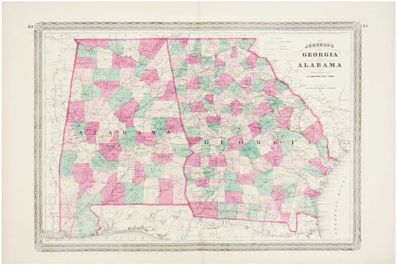
JOHNSON (Alvin Jewett).
Georgia and Alabama.
New York ,1863. 388 x 561 mm.
Référence libraire : LBW03586
|
|
|
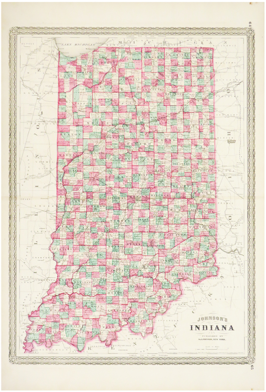
JOHNSON (Alvin Jewett).
Indiana.
New York, 1864. 585 x 435 mm.
Référence libraire : LBW03585
|
|
|
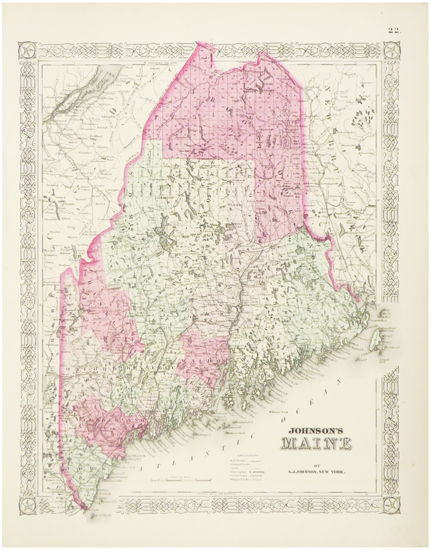
JOHNSON (Alvin Jewett).
Maine.
New York, 1864. 405 x 325 mm.
Référence libraire : LBW03582
|
|
|
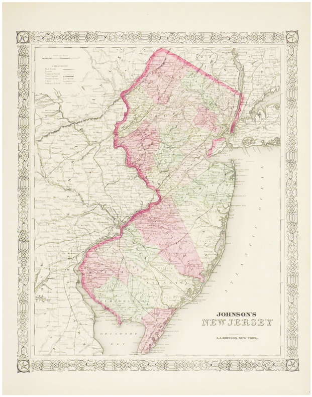
JOHNSON (Alvin Jewett).
New Jersey.
New York, 1864. 395 x 325 mm.
Référence libraire : LBW03581
|
|
|
JOHNSON (Alvin Jewett).
Pennsylvania and New Jersey.
New York, 1864. 435 x 601 mm.
Référence libraire : LBW03584

|
|
|
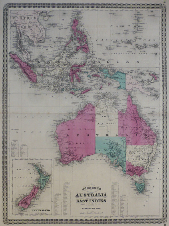
JOHNSON (Alvin Jewett);
Johnson's Australia and East Indies.
New York A.J. Johnson 1870 580 x 430 mm.
Référence libraire : LBW-1273
|
|
|
JOHNSON (Alvin Jewett);
Johnson's Florida.
New York A.J. Johnson 1870 300 x 377 mm.
Référence libraire : LBW-1265

|
|
|
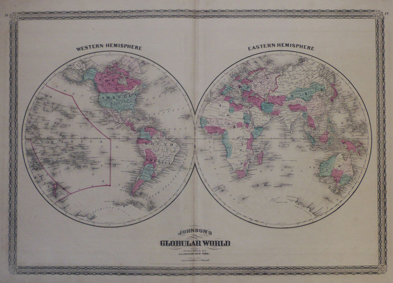
JOHNSON (Alvin Jewett);
Johnson's globular world.
New York A.J. Johnson 1870 408 x 585 mm.
Référence libraire : LBW-1258
|
|
|
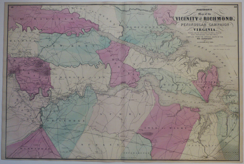
JOHNSON (Alvin Jewett);
Johnson's Map of the vicinity of Richmond, and peninsular campaign in Virginia.
New York A.J. Johnson 1870 446 x 671 mm.
Référence libraire : LBW-1264
|
|
|
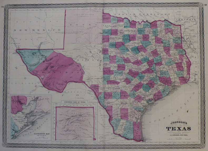
JOHNSON (Alvin Jewett);
Johnson's Texas.
New York A.J. Johnson 1870 423 x 585 mm.
Référence libraire : LBW-1266
|
|
|
JOHNSON (Alvin Jewett);
Johnson's United States.
New York A.J. Johnson 1870 422 x 582 mm.
Référence libraire : LBW-1260

|
|
|
JOHNSON (Alvin Jewett);
Johnson's Washington and Georgetown.
New York A.J. Johnson 1870 323 x 422 mm.
Référence libraire : LBW-1261

|
|
|
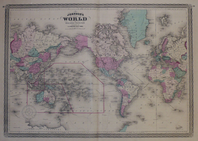
JOHNSON (Alvin Jewett);
Johnson's World on Mercator's projection.
New York A.J. Johnson 1870 412 x 585 mm.
Référence libraire : LBW-1259
|
|
|
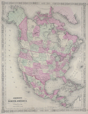
JOHNSON (Alvin Jewett);
North America.
New York 1864 564 x 435 mm.
Référence libraire : LBW0357d
|
|
|
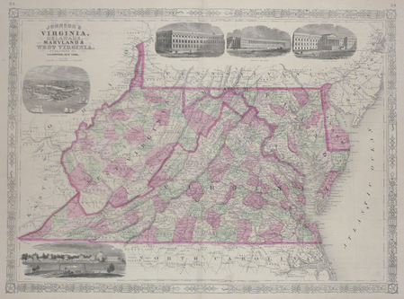
JOHNSON (Alvin Jewett);
Virginia, Delaware, Maryland & West Virginia.
New York 1864 430 x 587 mm.
Référence libraire : LBW03583
|
|
|
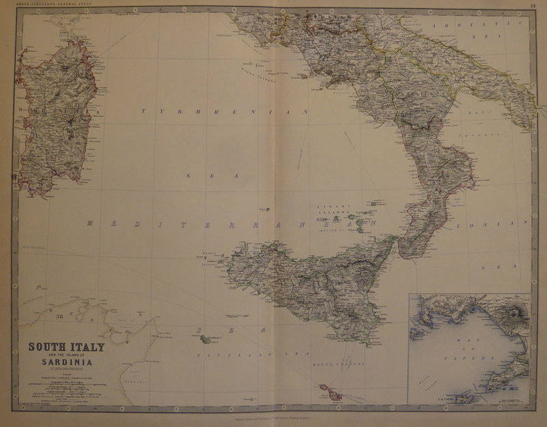
JOHNSTON (Keith);
South Italy and the island of Sardinia.
Edinburgh W. & A.K. Johnston 1884 450 x 573 mm.
Référence libraire : LBW-501
|
|
|
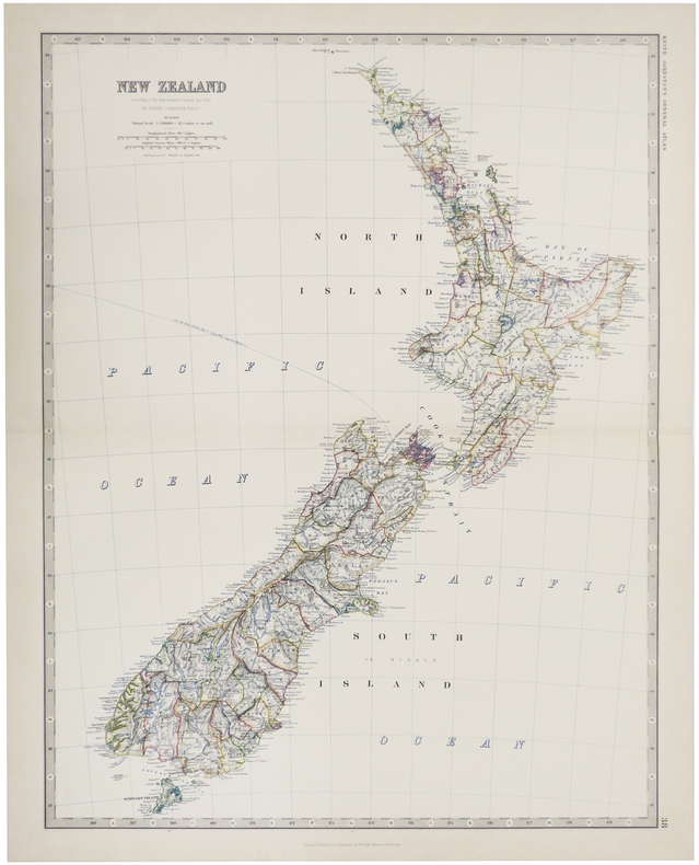
JOHNSTON (W. & A.K.).
New Zealand.
Edinburgh, 1884. 571 x 441 mm.
Référence libraire : LBW-509
|
|
|
Johnston, G. & P. Foote; Maps [Illustrator]
Saga of Gisli
J. M. Dent & Sons Ltd 1963-01-01. Hardcover. Good. Icelandic Sagas Hardcover and dust jacket. Good binding and cover. Shelf wear. Tears to jacket with loss. Scattered underlining and markings. <br> "The Saga of Gisli was written early in the 13th century. It offers an imaginative reconstruction of the story of a man and his family who came to Iceland from Norway about A.D. 950. Soon after 960 Gisli was outlawed for killing his brother-in-law and then for thirteen years or more he lived in hiding in remote parts of the northwest of Iceland until he was finally caught and killed by his enemies. J. M. Dent & Sons Ltd hardcover
Référence libraire : 2208290120 ISBN : 0460035754 9780460035750
|
|
|
Johnston, Keith
Spain - from Keith Johnston's Royal atlas of modern Geography. Spain and Portugal.
Edinburgh u. London, W. Blackwood, o.J. Gr.-8°. 1 mehrfachgef. Kte. a. Leinwand gezogen. Leinwand. Vergold. Deckeltitel. Cloth. Gilt title on spine. Stark ber. u. best. Stock- u. fingerfl. Rubbed and bumped. Foxed and stained.
Référence libraire : 43179AB
|
|
 Recevoir par e-mail
 Télécharger en PDF
 Flux RSS


