|
Kato Yabuko ed. First Edition Tenchi and Chitoku discoloration Text above average 5 maps attached to the end of the book Undisc
mountaineering No. 2
Tsukushi Mountain Club 1934. Soft Cover. Fine. Number of books: 1 Tsukushi Mountain Club paperback
Référence libraire : 2082702114600786
|
|
|
KATTEGAT OG BÆLTERNE - J. ROBIJN (JACOB ROBYN).
Pascaert Vant Schager-Rack en de Belt. van d'Paternoster tetin de Oest Zee. Op Nieuws Verbetert door J. Robyn.
(Amsterdam), 1696. 52x59,5 cm. Kobberstukket og håndkoloreret søkort visende Bælterne mellem Østjylland, Fyn, Sjælland, Lolland og Falster, Sydsverige, Rü Bornholm, Nordtyskland m.v. Med det danske rigsvåben i nederste højre hjørne" heri dedikation til Cornelis Tromp, den danske og hollandske flådes admiral. Den store kartouche i øverste venstre hjørne viser scener fra folkelivet og brydning af kalksten fra Møn eller Stevns. Fin reparation i højre margin.
Référence libraire : 47333

|
|
|
KATTEGAT OG BÆLTERNE - J. ROBIJN (JACOB ROBYN).
Pascaert Vant Schager-Rack en de Belt. van d'Paternoster tetin de Oest Zee. Op Nieuws Verbetert door J. Robyn.
(Amsterdam), 1696. 52x59,5 cm. Kobberstukket og håndkoloreret søkort visende Bælterne mellem Østjylland, Fyn, Sjælland, Lolland og Falster, Sydsverige, Rü Bornholm, Nordtyskland m.v. Med det danske rigsvåben i nederste højre hjørne " heri dedikation til Cornelis Tromp, den danske og hollandske flådes admiral. Den store kartouche i øverste venstre hjørne viser scener fra folkelivet og brydning af kalksten fra Møn eller Stevns. Fin reparation i højre margin.
|
|
|
KATTEGAT OG SUNDET - DECRES, C. (DENIS DUC DE DECRES).
Carte réduite du Cattegat comprenant La Côte de Suede depuis Marstrand jusqu'a Landscrone. La côte du Jutland depuis le Cap Skagen jusqu'à l'Entrée des Belts a la Cô septentrionale de l'Ile de Séelande d'apres les Observations et les Cartes Danoi...
(Paris), Au Depot général dee la Marine, 1813. 85x59 cm. Kobberstukket kort i stort format over Kattegat og den nordlige del af Øresund med København i syd, den svenske vestkyst fra Tjørnø i nord til Barsebæk i syd. Jyllands østkyst fra Skagen i nord til Gylling Næs i syd med øerne Anholt, Læsø, Samsø, Endelave m.v. Lidt rifter i højre marginsom ikke når bileldfladen. Fint rent eksemplar.
Référence libraire : 47340
|
|
|
KATTEGAT OG SUNDET - DECRES, C. (DENIS DUC DE DECRES).
Carte réduite du Cattegat comprenant La Côte de Suede depuis Marstrand jusqu'a Landscrone. La côte du Jutland depuis le Cap Skagen jusqu'à l'Entrée des Belts a la Cô septentrionale de l'Ile de Séelande d'apres les Observations et les Cartes Danoi...
(Paris), Au Depot général dee la Marine, 1813. 85x59 cm. Kobberstukket kort i stort format over Kattegat og den nordlige del af Øresund med København i syd, den svenske vestkyst fra Tjørnø i nord til Barsebæk i syd. Jyllands østkyst fra Skagen i nord til Gylling Næs i syd med øerne Anholt, Læsø, Samsø, Endelave m.v. Lidt rifter i højre marginsom ikke når bileldfladen. Fint rent eksemplar.
|
|
|
Kauffmann, Jean-Paul; Maps [Illustrator]
Voyage to Desolation Island
Harvill Press 2001-01-01. Hardcover. New. In shrink wrap. Looks like an interesting title! Harvill Press hardcover
Référence libraire : Q-1860469264 ISBN : 1860469264 9781860469268

|
|
|
Kavanagh, Martin
The Assiniboine Basin - A Social Study of Discovery, Exploration and Settlement: With Many Illustrations and Maps
282 pages. Index. Black and white photographic plates. Two fold-out maps. "The author has selected Brandon, a typical Assinniboine basin city, to illustrate civic development on the prairies." - from Preface. Prior owner's name and date upon front free endpaper. Binding intact. Average wear. A sound copy of this informative work. Peel (2nd Edn) 3990. Book

|
|
|
Kay-Robinson, Denys
The Landscape of Thomas Hardy
No marks or inscriptions. A very clean very tight copy with bright unmarked boards, very minor traces of foxing to page edges and no bumping to corners. Dust jacket not price clipped or marked or creased with one cm enclosed tear to spine and rubbing to top of spine. 240pp. This book takes the reader through the geographical area of Thomas Hardy's novels region by region, pointing out the association of each place in its geographical order.

|
|
|
Kazantzis, B.
Greece : The Land for All Seasons
No marks or inscriptions. Slight creasing to covers. A very clean very tight copy with bright unmarked very slightly foxed boards and no bumping to corners. 42pp. Tourist brochure on Greece in the early 1970s. Well illustrated.

|
|
|
Keegan, John & Wheatcroft, Andrew
Zones of conflict : an atlas of future wars
158pp. 25 cm. Hardcover Very good condition good
|
|
|
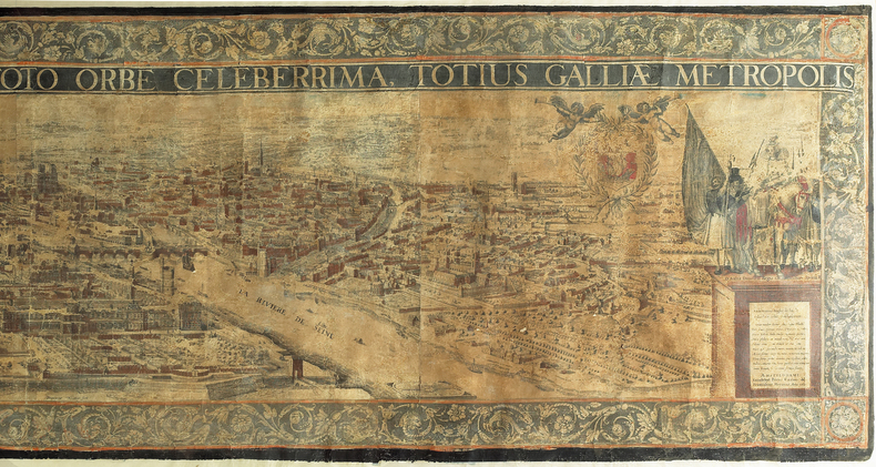
KEERE (Pieter van den) & HOEY (François van).
Lutetia Parisiorum urbs regia Academia toto orbe celeberrima totius Galliae metropolis.
[Amsterdam, 1617]. En quatre feuilles jointes de 590 x 2240 mm ; encadré sous verre.
Référence libraire : LBW-982
|
|
|
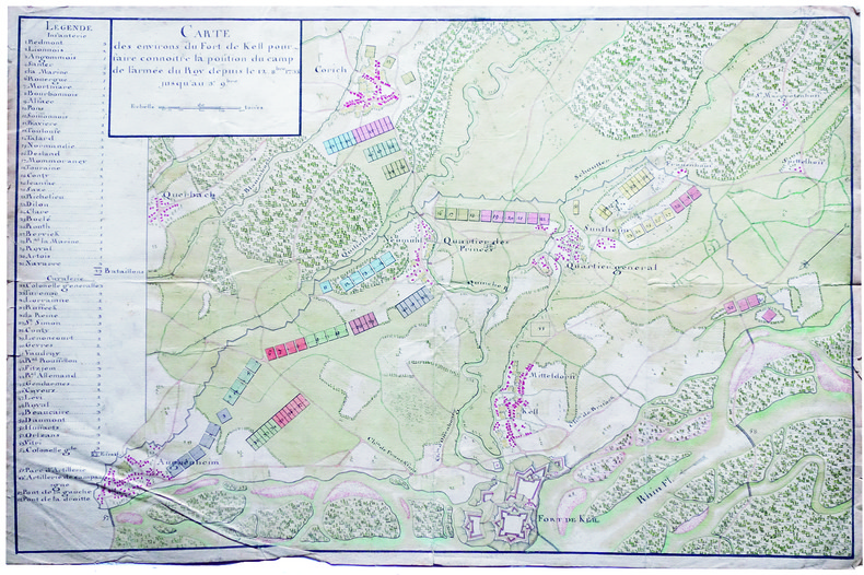
KEHL. MANUSCRIT.
Carte des environs du fort de Kell pour faire connoitre la position du camp de l'armée du roy depuis le 12 8.bre 1733 jusqu'au 3e 9.bre.
1733. 357 x 545 mm.
Référence libraire : LBW-4135
|
|
|
Keiichiro Ishino / Written by Meiji Maps
School children's ship in the middle of the war Okinawa evacuation ship Tsushima Maru Incident Meiji Zhusho Junior High School Student Library 29
Not Available 1978. Soft Cover. Fine. The book is in fine condition. Not Available paperback
Référence libraire : 2090502113715672
|
|
|
Keiichiro Ishino / Written by Meiji Maps
Tower of Himeyuri Meiji Zusho Junior High School Student Bunko 12
Not Available 1979. Soft Cover. Fine. The book is in fine condition. Not Available paperback
Référence libraire : 2090502113710013
|
|
|
Kelek:
Série de 6 cartes postales.
Carton éditions, 1984. 6 cartes postales, à l'état de neuf.
Référence libraire : 26404

|
|
|
Kelleher, D. L.
Ireland of the Welcomes
No marks or inscriptions. Creasing/rubbing to oversize parts of covers. A clean very tight copy with slightly dusty unmarked boards, dusty page edges and no bumping to corners. 144pp. Tourist guide to Ireland with some photographs. Undated ca 1930s.

|
|
|
KELLER (François-Antoine-Édouard).
[ANTILLES] Carte de la partie des Antilles comprise entre la Martinique et S.t Christophe.
[Paris], Dépôt Général de la Marine, 1843. 901 x 602 mm.
Référence libraire : LBW-8308

|
|
|
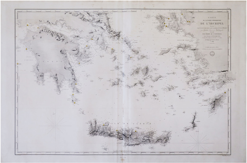
KELLER (François-Antoine-Édouard).
[MER ÉGÉE/CYCLADES] Carte de la partie méridionale de l'archipel.
[Paris], Dépôt-Général de la Marine, 1854-1864. 591 x 880 mm.
Référence libraire : LBW-8307
|
|
|
Keller, Heinrich (1778-1862)
Panorama der Katze - Gebirgs-Kette von Zürich aus. - (II:) Darstellung der von Zürich aus sichtbaren Gebirge / Vue des Alpes prise depuis la ville de Zürich. - (III:) Höhen-Vergleichung der von Zürich aus sichtbaren Gebirge.
(Zürich, Füssli Komm., 1813). 3 Umrissradierungen. I: 150 x 17 cm. - II: 62 x 17 cm. - III: 37 x 12,5 cm. + Wichtig: Für unsere Kunden in der EU erfolgt der Versand alle 14 Tage verzollt ab Deutschland / Postbank-Konto in Deutschland vorhanden +
Référence libraire : 715CG
|
|
|
Keller, Heinrich (1778-1862):
Panorama der Katze - Gebirgs-Kette von Zürich aus. - (II:) Darstellung der von Zürich aus sichtbaren Gebirge / Vue des Alpes prise depuis la ville de Zürich. - (III:) Höhen-Vergleichung der von Zürich aus sichtbaren Gebirge.
(Zürich, Füssli Komm., 1813). 3 Umrissradierungen. I: 150 x 17 cm. - II: 62 x 17 cm. - III: 37 x 12,5 cm.
Référence libraire : 715CG
|
|
|
Keller, Heinrich.
Panorama prise au Sommet du Mont Rigi. Zurich, Keller & Füssli, (1816).
8vo. Fan-folded, hand-coloured aquatint (with 9 folding double leaves, c. 195 x 1980 mm) in contemporary blindstamped blue boards with floral design and mounted border. In slipcase with mounted title. The finest and rarest of Keller's panoramas in contemporary colour, depicting the view from Mount Rigi from Risch on Lake Zug to Kuessnacht on Lake Lucerne. Not to be confused with Keller's much more common like-titled panoramas of merely half size, published from 1820 onwards (cf. Harteveld Cat. 206, no. 123: their copy described as "splendidly coloured copy, then sold for the fourfold price of copies in simple colour"). In 1823 Keller was to publish yet another large-format panorama as part of a book with the same title, again not identical with this present view. - The title label bears the publisher note as quoted above; the view itself is captioned: "Gezeichnet auf dem Rigi-Kulm, 1814, von H. Keller, Vermehrt u. Berichtigt 1816 / gestochen von J. J. Scheurmann 1815". Two flaps (measuring 70 x 160 mm) can be folded out at the bottom, through with the view includes Arth on Lake Zug. Similarly, Mount Rossberg is also inserted as a flap, behind which the viewer may uncover Lake Aegeri and Eccehomo. Mounted on the back pastedown is a coloured engraving: "Le Mont Righi, dessiné près de Zoug" (175 x 107 mm; B. Bullinger del., F. Hegi sc.). - Minute paper defect on the horizon at far left, otherwise in perfect condition. Binding with occasional insignificant staining; altogether very clean. Insignificant bumping to edges of slipcase. Ms. ownership note by the Austrian actor Joseph Koberwein (1774-1857). The son of the important travelling actor Simon Friedrich Koberwein made his debut in 1796 at the Vienna Court Theatre and remained as a member of the ensemble until 1846. His principal roles were Ferdinand, Leicester, and Wallenstein. - Very rare; library and collection catalogues (OCLC, British Library, etc.) list only the later editions. Cf. Lonchamp 1672 (note). Barth 193787ff. (book edition only).

|
|
|
Kelter, Edmund.
Eine Elbkarte des 16. Jahrhunderts im Museum für Hamburgische Geschichte.
Hamburg in Komm. bei Otto Meissner 1919. . Ecken etw. gestaucht sonst gut erhalten. - Möller/Tecke I 441. Hamburg, in Komm. bei Otto Meissner, 1919. unknown
Référence libraire : 18167

|
|
|
KENNEDY, T F & PETRO, JULIUS (Maps) & FORSDYKE, LIONEL (Maps)
A Descriptive Atlas of the Pacific Islands
Reed Education 1976. Imperial octavo softcover VG; all our specials have minimal description to keep listing them viable. They are at least reading copies complete and in reasonable condition but usually secondhand; frequently they are superior examples. Ordering more than one book may reduce your overall postage costs. Reed Education 1976 paperback
Référence libraire : 320362
|
|
|
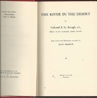
Keogh, Colonel E. G.; maps and illusts by Joan Graham
River In The Desert The The Mesopotamian Campaign of WWI
Wilke & Co Melbourne 1955. Hardcover. Original cloth. Very Good . AUSTRALIAN MILITARY World War I - Study of the Mesopotamian Campaign of WWI. Includes details of the occupation of Basra the advance to Amara the battles of Kut-el-amara and a review of the campaign.First Edition 215 p. : ill. maps some col. ; 22 cm. no dustjacket PART I -DEFEAT I THE LAND AND ITS PEOPLE 15 II PRELUDE TO WAR 23 Balance of Power .24 Drive to the East 25 Outbreak of War in 1914 29 Stalemate in the West 32 The Turkish Army 34 III THE OCCUPATION OF BASRA 37 Orders to LE.F. ""D"" 39 Turkish Forces in Iraq 40 The Landing 41 Advance to Basra 42 The Decision to Advance 45 The Turkish Counter-Offensive 49 IV THE ADVANCE TO AMARA 52 Reorganization of IE.F. ""D"" 53 Nixon and His Instructions 54 Operations in Arabistan 56 Townshend's Regatta 58 V CTESIPHON 68 Battle of Kut-el-Amara 72 The Decision to Strike for Baghdad 78 Battle of Ctesiphon 81 The Retreat to Kut 88 VI THE SIEGE OF KUT-EL-AMARA 91 Sheikh Saad 94 Battle of the Wadi 108 Battle of Hanna 112 ReorganizationJ 1 114 Battle of Dujaila 11 . Capitulation of Kut 121 Comments 126 VII BACKGROUND TO TRAGEDY 131 PART II - VICTORY VII INTERREGNUM 147 Policy after the Fall of Kut 147 Administrative Reorganization 150 Reorganization of the Command 154 Tactical Developments 155 Another Policy Change 156 IX SECOND BATTLE OF KUT-EL-AMARA 158 The Advance to the Hai 160 Clearing the Right Bank 161 British Plans 165 The Assault on Sannaiyat 166 The Crossing at Shumran 167 Exploitation 168 Comments 178 X BAGHDAD. 180 The Decision to Advance 182 The Pause at Aziziya 184 Resumption of the Advance 185 Capture of Baghdad 188 Comments 190 XI THE LAST PHASE 192 Junction with the Russians 193 Operations on the Adhaim 196 Turkish Reaction 197 Dunsterforce 200 The Last Phase 201 XII REVIEW OF THE CAMPAIGN 203. Notes: Bibliography: p. 215. Subject: Australia. Military Training Directorate World War 1914-1918 -- Campaigns -- Iraq #270925 Elizabeth's Bookshops have been one of Australia's premier independent book dealers since 1973. Elizabeth's family-owned business operates four branches in Perth CBD Fremantle WA and Newtown NSW. All orders are dispatched within 24 hours from our Fremantle Warehouse. All items can be viewed at Elizabeth's Bookshop Warehouse 23 Queen Victoria Street Fremantle WA. Hardcover. Original cloth Very Good Wilke & Co, Melbourne hardcover
Référence libraire : 92718
|
|
|
Kepanga Mundiya Dozier Marc
L'étrange tribu des français
PLUME CAROTTE 2021 56 pages 23 5x23 5x1 2cm. 2021. Relié. 56 pages.
Référence libraire : 500048746

|
|
|
Kepanga Mundiya Dozier Marc
L'étrange tribu des français
PLUME CAROTTE 2021 56 pages 23 5x23 5x1 2cm. 2021. Relié. 56 pages.
Référence libraire : 500077126

|
|
|
Kepanga Mundiya Dozier Marc
L'étrange tribu des français
PLUME CAROTTE 2021 56 pages 23 5x23 5x1 2cm. 2021. Relié. 56 pages.
Référence libraire : 500078502

|
|
|
Kepanga Mundiya Dozier Marc
L'étrange tribu des français
PLUME CAROTTE 2021 56 pages 23 5x23 5x1 2cm. 2021. Relié. 56 pages.
Référence libraire : 500078507

|
|
|
Kepanga Mundiya Dozier Marc
L'étrange tribu des français
PLUME CAROTTE 2021 56 pages 23 5x23 5x1 2cm. 2021. Relié. 56 pages.
Référence libraire : 500084134

|
|
|
Kepanga Mundiya Dozier Marc
L'étrange tribu des français
PLUME CAROTTE 2021 56 pages 23 5x23 5x1 2cm. 2021. Relié. 56 pages.
Référence libraire : 500084135

|
|
|
Kepanga Mundiya Dozier Marc
L'étrange tribu des français
PLUME CAROTTE 2021 56 pages 23 5x23 5x1 2cm. 2021. Relié. 56 pages.
Référence libraire : 500092511

|
|
|
Kepanga Mundiya Dozier Marc
L'étrange tribu des français
PLUME CAROTTE 2021 56 pages 23 5x23 5x1 2cm. 2021. Relié. 56 pages.
Référence libraire : 500092512

|
|
|
KERMAINGANT, Mathurin François.
Mémoire sur le Projet d’un Chemin de Fer de Lyon à Marseille. Ministère des Travaux Publics de l’Agriculture et du Commerce. Direction Générale des Ponts et Chaussées et des Mines.
Paris, Imprimerie Royale, 1837. In-4 – 22,5 x 29 cm. Broché. 172 pages, 1 carte dépliante en 2 parties. Edition originale. Ouvrage complet de sa grande « Carte Générale des tracés du Chemin de Fer de Lyon à Marseille » très détaillée (150 x 57cm). On découvre le tracé proposé sur la rive droite du Rhône, rehaussé en vert, et celui sur la rive gauche du Rhône, rehaussé en rouge, les deux se rejoignant à Tarascon puis poursuivant par Arles et les Martigues. Un tracé alternatif de la rive gauche, rehaussé en jaune, entre la Durance et Marseille, envisage une bifurcation à partir d’Avignon en passant par Orgon, Salon, Aix, Fuveau, Aubagne et la vallée de l’Huveaune. Mathurin François Kermaingant (1779-1856) est un ingénieur originaire du Nord de la France. Il intègre l'école des Ponts et Chaussées en 1800. Quatre ans plus tard, il est affecté au service de route de la Drôme. Il quitte ce département pour celui du Rhône en 1810, puis y revient en 1821, pour 3 années. C'est dans la Sarthe qu'il poursuit sa carrière à partir de 1824. A la demande du gouvernement, il pilote la commission d'étude sur un futur chemin de fer dans la vallée du Rhône en 1833. Il suggère de nombreuses variantes de tracés. En 1836, il est nommé ingénieur en chef. Il quitte le sud de la France puis s'occupe du chemin de fer de Paris à Versailles.
Référence libraire : 2321

|
|
|
Kettle, Michael; Maps/ Plates [Illustrator]
The Allies and the Russian Collapse March 1917 - March 1918 Russia and the Allies 1917-1920 Volume One
University Of Minnesota Press 1981-01-01. Paperback. Very Good. Please Read price clipped inside cover - No marks on text - My shelf location 41-e-22 University Of Minnesota Press paperback
Référence libraire : 211002002 ISBN : 0816609810 9780816609819

|
|
|
KEULEN (Johannes van).
Paskaart van Gallissien van C. de Finisterre tot aen Zurara.
Amsterdam, [circa 1700]. 505 x 567 mm.
Référence libraire : LBW-950

|
|
|
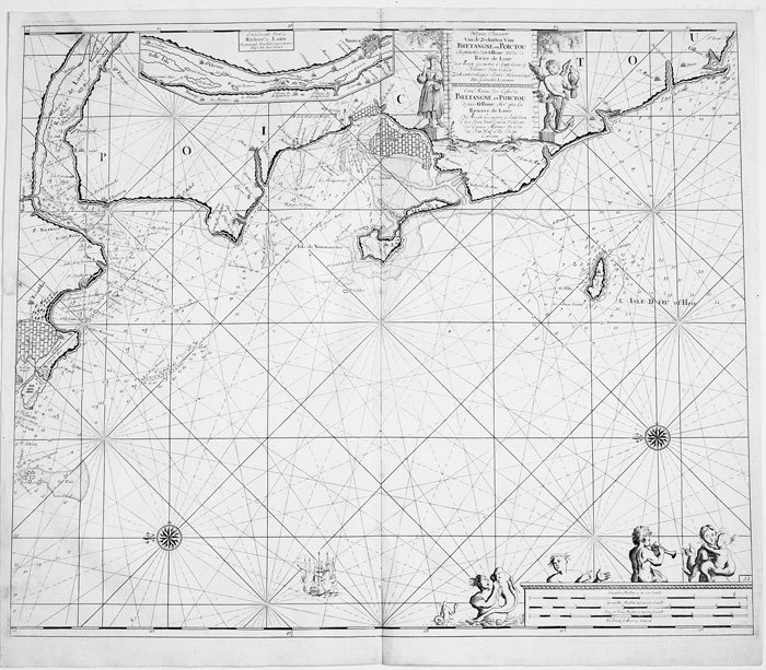
KEULEN (Johannes van);
Nieuwe pascaart van de zeekusten van Bretangne en Poictou.
Amsterdam circa 1700 494 x 583 mm.
Référence libraire : LBW-811
|
|
|
KEULEN (Johannes van);
Nieuwe pascaart van een gedeelte van Bretangne.
Amsterdam circa 1700 513 x 592 mm.
Référence libraire : LBW-814

|
|
|
KEULEN (Johannes van);
Pascaart van de zeekusten van Galissen.
Amsterdam circa 1700 511 x 588 mm.
Référence libraire : LBW-818

|
|
|
Key Maps
Houston Harris County 2013 Key Map 52nd Edition
Used - Very Good. Used book that is in excellent condition. May show signs of wear or have minor defects. unknown
Référence libraire : 54927133-6 ISBN : 1885822707 9781885822703
|
|
|
Key Maps
Houston Harris County atlas
unknown_binding. Good. Access codes and supplements are not guaranteed with used items. May be an ex-library book. unknown
Référence libraire : 1885822146.G ISBN : 1885822146 9781885822147
|
|
|
Key Maps
The Multi-Color Houston and Harris County Atlas
Key Maps Inc. 1982. Orange binder has light wear a few smudges. Title page lightly stained. Text has no markings. Binder. Good/No Jacket. 4to - over 9¾" - 12" tall. Key Maps, Inc. Hardcover
Référence libraire : 004682J
|
|
|
Khaled Al Ankary
La Péninsule arabique dans les cartes européennes anciennes, fin XVème- début XIXème siècle. Collection Khaled Al Ankary. Exposition du 15 Septembre au 28 Octobre 2001/ The arabian peninsula In old european maps. From the end of 15th century to the beginning of 19th century. Khaled Al Ankary collection. Exhibition from September 15th to October 28th 2001.
Institut du monde arabe, Paris 2001. Hardcover Sehr gut
Référence libraire : 032557

|
|
|
KIEPERT (Heinrich).
[EMPIRE OTTOMAN] Karte des Türkischen Reichs in Asien.
Berlin, S. Schropp u. Comp, 1853. En 21 sections montées sur toile et repliées, formant une carte de 633 x 920 mm ; sous chemise et étui de papier marbré vert de l'époque, avec titre en lettres dorées sur pièce de titre rouge ; étiquette au dos de l'éditeur parisien J. Andriveau-Goujon.
Référence libraire : LBW-8624

|
|
|
Kiepert, H(einrich)
Karte des russischen Reichs in Europa. Maßstab 1 : 3.000.000.
Berlin, Dietrich Reimer, 1893. Farblithografie, zwei Teile je 122,5 x 67,5 cm (Blattgr. 137,5 x 71 cm) in zus. 88 Segmenten auf Leinen aufgezogen. Zusammen in Leinenschuber d. Zt. mit Titelschild der Londoner Landkartenhandlung Edward Stanford, r1 6. verb. Auflage. (dieser mit geringen Gebrauchsspuren).
Référence libraire : 49033AB

|
|
|
Kiepert, Richard
4 Karten aus Richard Kiepert's Deutschen Kolonial-Atlas für den amtlichen Gebrauch in den Schutzgebieten.
Berlin, Dietrich Reimer, (1893). Ca. 75 x 57 cm. 4 Farblithografien, gefaltet. Zusammen lose in HLn.-Band der Zeit mit aufkaschiertem Deckeltitel, ko (etwas angeschmutzt und fleckig).
Référence libraire : 49113AB

|
|
|
Kiesel, O.E. [Otto Erich] (Bearb.)
Hamburg. Führer durch die Freie und Hansestadt und ihre Umgebung. Offizieller Führer des Fremdenverkehrs-Vereins Hamburg. 3., stark erweiterte Ausgabe.
Hamburg, Broschek & Co. 1924. 184 S. incl. 24 S. Anzeigenanhang. Mit Vignetten u. zahlr., tls. ganzseit. Abb. in Kupfertiefdruck 2 eingeschalt. Verkehrslinien-Plänen, 1 Tafel mit Ohlsdorf-Plan sowie 1 mehrfach gefalteten farbigen Pharus-Straßenplan im Anhang (Maßstab 1 : 14700; 40 x 50,5 cm). Farb. illustr. OBrosch.
Référence libraire : 88292

|
|
|
KILIAN (Georg Christophe);
[NORVEGE] Schloss Bahus in Norwegen.
Augsbourg circa 1740 163 x 177 mm.
Référence libraire : LBW061eb

|
|
|
KILIAN Conrad:
Au Hoggar. Mission de 1922.
Paris, Société d'éditions géographiques, maritimes et coloniales, 1925. In-8 broché de [2]-190 pages, couverture verte imprimée en noir, ornée d'une vignette qu'on retrouve au dos (passé). Bords du premier plat insolés, déchirure sans perte au second plat. Intérieur frais, en majeure partie non coupé.
Référence libraire : 10484

|
|
|
Kilmann Ralph H
Social Systems Design: Normative Theory and the Maps Design Technology
Elsevier Science Ltd 1977 344 pages in8. 1977. Cartonné jaquette. 344 pages.
Référence libraire : 100125543 ISBN : 444001980

|
|
|
Kimble, George HT.; Illustrated by Maps, photos [Illustrator] H. T.
Tropical Africa: Volume I Land and Livelihood and Volume II Society and Polity
20th Century Fund 1960-01-01. Hardcover. Very Good/Unclipped . 0x0x0. Both volumes in this set are immaculate and unmarked except for former owner's name on front end pages; many interesting period photos in both vols.; bindings firm; boards fine well-protected by very good d.j.s having minimal wear. Collectible first edition. 20th Century Fund hardcover
Référence libraire : 042296
|
|
 Recevoir par e-mail
 Télécharger en PDF
 Flux RSS


