|
Mannert, Conrad
Helvetien nach den zuverlässigsten astronomischen Bestimmungen, aus den Charten von Weisse, Bacler d'Albe, Mallet, Feer, und andern einzelnen Blättern zusammengesezt von Conrad Mannert. [Altkolorierter Original-Kupferstich / original colored copper engraving].
o.J. Konrad Mannert, geboren am 17. April 1756 in Altdorf bei Nürnberg, gestorben am 27. September 1834 in München. Historiker und Geograph. [2 Warenabbildungen]
Referentie van de boekhandelaar : 12043DB

|
|
|
Manning, Conleth
Rock of Cashel : Co. Tipperary
No marks or inscriptions. No creasing to covers or to spine. A very clean very tight copy with bright unmarked boards, the tiniest of rubs to lower front edge and no bumping to corners. 44pp. Guide to the Rock of Cashel in Tipperary, Ireland. Well illustrated.

|
|
|
MANOYER (François).
[TOULON] La Flotte française en rade de Toulon. Visite du Président de la République et de l'escadre italienne.
Toulon, Clavel, [1890]. 266 x 747 mm.
Referentie van de boekhandelaar : LBW-6429

|
|
|
Mansfeld, Johann.
Grundriß der Stadt Wien 1812. Vienna, Artaria, 1812.
630:780 mm. Engr. map in original colour. Original Biedermeier frame with four brass corner fittings. This city map showing 1317 houses with their respective numbers was first published in 1802 as "Historischer Grundriß der Stadt Wien". It also shows two small historical plans (during the second Turkish siege in 1683 and in the 12th century). - Formerly owned by Katharina Schratt and removed from the so-called Schratt Villa in Hietzing's Gloriettegasse; cf. the written statement by the heirs of the map's last owner, the collector Josef Ringer (1916-2008). Eckl coll. IV, 755. Not in Mayer coll.

|
|
|
MANSO PORTO, Carmen.
Cartografía Histórica de América. Catalogo de Manuscritos de los Siglos XVIII y XIX. Presentación de Antonio López Gómez.
Madrid, 1997. Folio; XXXII pp., 143 pp., 1 h., con 108 reproducciones en color de mapas. Cubiertas originales.

|
|
|
MANSO PORTO, Carmen.
Cartografía Histórica Portuguesa. Catálogo de Manuscritos de los Siglos XVII y XVIII.
Madrid, 1999. Folio; 170 pp. Con reproducción de mapas en color. Cubiertas originales.

|
|
|
MANUSCRIPT MAP.
Grund Tegning af Fästningen og Castellet i Leystad.
No place and date (probably Denmark, late 18th century). Hand painted map in ink and water colour. 26,5 x 41 cm. Silver frame. Overall slightly foxed.
|
|
|
MANUSCRIPT MAP.
Grund Tegning af Fästningen og Castellet i Leystad.
No place and date (probably Denmark, late 18th century). Hand painted map in ink and water colour. 26,5 x 41 cm. Silver frame. Overall slightly foxed.
Referentie van de boekhandelaar : 39180
|
|
|
MANUSCRIPT MAP.
Slaget wed Zornsdorff den 25de Augusti 1758.
No place and date. (probably Denmark late 18th century). Handpainted map in ink and watercolour. 25 x 41 cm. In silver frame. Slightly foxed overall.
|
|
|
MANUSCRIPT MAP.
Slaget wed Zornsdorff den 25de Augusti 1758.
No place and date. (probably Denmark late 18th century). Handpainted map in ink and watercolour. 25 x 41 cm. In silver frame. Slightly foxed overall.
Referentie van de boekhandelaar : 39179
|
|
|
MANUSCRIT.
[ARGENTRÉ/MAYENNE] Atlas des propriétés composant la Terre d'Argentré, sous Laval, appartenant à Monsieur le Comte de Cintré. Les plans ont été rectifiés conformément à la nouvelle composition des fermes, par Louis Duluard, expert-géomètre, à Château-Gontier, le 1er octobre 1875.
Château-Gontier, 1875. In-folio ; demi-basane verte, dos lisse muet, étiquette de titre sur le premier plat (reliure de l'époque).
Referentie van de boekhandelaar : LBW-8229

|
|
|
MANUSCRIT.
[AUBE] Extrait du plan parcellaire de la commune de Barberey S.t Sulpice. Plan du château de Barberey S.t Sulpice et de ses environs appartenants à Monsieur Bruslé, préfet du département de l'Aube, Officier de la Légion d'Honneur.
[vers 1805]. En deux feuilles jointes formant un plan de 660 x 590 mm.
Referentie van de boekhandelaar : LBW-8228

|
|
|
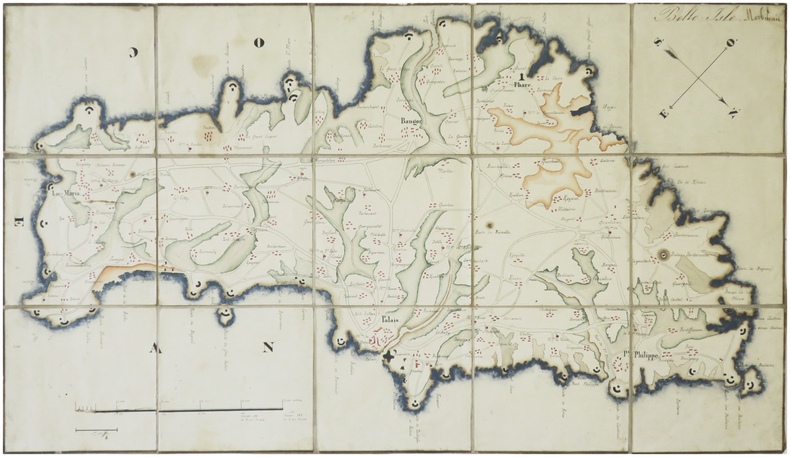
MANUSCRIT.
[BELLE-ÎLE-en-MER] Belle Isle. Morbihan.
[milieu du XIXe siècle]. En 15 section montées sur toile et repliées, formant une carte de 242 x 430 mm.
Referentie van de boekhandelaar : LBW-8230
|
|
|
Manzù, Giacomo, Italian sculptor (1908-1991).
"Andiamo nel separé". No place, c. 1940.
Signed drawing, felt-tip pen on cardboard, c. 430 x 300 mm. Erotic sketch in red felt-tip pen on ochre cardboard, the result of Manzu's collaboration with his friend and colleague Edmund Georg Pielmann.

|
|
|
MAP AFRICA FENNER REST.
Africa
London.: Robert Jennings. 1830. Engraved map 11.5 x 14.3 cm showing route of European explorers faint added outline colour in an early hand and manuscript note to the verso in the same ink edges age-toned but in very good condition. Detailed pre-colonial map of Africa "Regions Unexplored" marked and "no fresh water to be found" on the west coast. An early manuscript inscription on the verso refers to Lander's ."wanderings of Clapperton" the Scottish naval officer and explorer. Richard Lander had returned with Hugh Clapperton's journal following his death and the account was published in the same year as Fenner's "Pocket Atlas of Modern & Ancient Geography" for which this map was prepared. . (Robert Jennings) unknown
Referentie van de boekhandelaar : 176607
|
|
|
MAP - AMERICA - ADOLF STIELER.
Der nordöstliche Theil der Vereinigten Staaten von Nord America Neue Bearbeitung von Ad.St. 1831.
(Gotha, Justus Perthes), 1831. Engraved map (34,5 x 43 cm.). Handcoloured in outline. Gestochen von Joh. Carl Ausfeld.
|
|
|
MAP - AMERICA - ADOLF STIELER.
Der nordöstliche Theil der Vereinigten Staaten von Nord America Neue Bearbeitung von Ad.St. 1831.
(Gotha, Justus Perthes), 1831. Engraved map (34,5 x 43 cm.). Handcoloured in outline. Gestochen von Joh. Carl Ausfeld.
Referentie van de boekhandelaar : 55743
|
|
|
MAP - AMERICA - STÜLPNAGEL, F. v.
America gezeichnet von F.v. Stülpnagel.
(Gotha, Justus Perthes), 1843. Engraved map (44 x 34 cm.). Handcoloured in outline. Having both North- and South America. Gest. von W. Behrens.
|
|
|
MAP - ARCTIC REGIONS.
Geological Map of the Arctic. Prepared by the First International Symposium on Arctic Geology sponsored by the Alberta Society of Petroleum Geologists.
Calgarry - Alberta Canada, Symposium Committee, 1960. (102 x 115 cm.). Large colourprinted circular map of the Arctic Regions. Folded. Well-preserved.
|
|
|
MAP - ARCTIC REGIONS.
Geological Map of the Arctic. Prepared by the First International Symposium on Arctic Geology sponsored by the Alberta Society of Petroleum Geologists.
Calgarry - Alberta Canada, Symposium Committee, 1960. (102 x 115 cm.). Large colourprinted circular map of the Arctic Regions. Folded. Well-preserved.
Referentie van de boekhandelaar : 55325
|
|
|
MAP - AUSTRALIA - STÜLPNAGEL, F. v.
Festland von Australien und benachbarte Inseln.
(Gotha, Justus Perthes), 1841. Engraved map (35,5 x 43,5 cm.). Handcoloured in outline. Fine and clean.
|
|
|
MAP - AUSTRALIA - STÜLPNAGEL, F. v.
Festland von Australien und benachbarte Inseln.
(Gotha, Justus Perthes), 1841. Engraved map (35,5 x 43,5 cm.). Handcoloured in outline. Fine and clean.
Referentie van de boekhandelaar : 55741
|
|
|
MAP - BRAZIL. - EDWARD STANFORD.
Brazil from official and other Sources prepared in the international Bureau of the American Republics, Williams C. Fox, Director.
London, Edward Stanford, 1905. (95 x 95,5 cm.). A large lithographed map of Brazil, lithographed in colours, original linen-backed and folded in 35 sections. Folded in the original cloth-case with the original printed title-label preserved. A fine copy.
|
|
|
MAP - BRAZIL. - EDWARD STANFORD.
Brazil from official and other Sources prepared in the international Bureau of the American Republics, Williams C. Fox, Director.
London, Edward Stanford, 1905. (95 x 95,5 cm.). A large lithographed map of Brazil, lithographed in colours, original linen-backed and folded in 35 sections. Folded in the original cloth-case with the original printed title-label preserved. A fine copy.
Referentie van de boekhandelaar : 57772
|
|
|
MAP - GIBRALTAR.
Nueba Vista Gibraltar. 1782.
Wien, L. Hochenleiter, um 1782. (22 x 37 cm.). Engraved map (bird-eye-view) with ships in the sea, fortification and bombardment. Text in Spanish. Mildly brownspotted.
|
|
|
MAP - GIBRALTAR.
Nueba Vista Gibraltar. 1782.
Wien, L. Hochenleiter, um 1782. (22 x 37 cm.). Engraved map (bird-eye-view) with ships in the sea, fortification and bombardment. Text in Spanish. Mildly brownspotted.
Referentie van de boekhandelaar : 55917
|
|
|
MAP - GIBRALTAR.
Plan der Berühmten Vestung Gibraltar belagert von den Spaniern und Frantzosen seit Anno 1779.
(Frankfurt am M., um 1780). (36 x 26 cm.) Engraved handcoloured map/plan of Gibraltar with text and with insets of Southern Span and North Africa around Ceuta and Tanger. A stamp in upper left corner. I.M. Zell, sculp. (Johann Michael Zell)Some brownspots.
|
|
|
MAP - GIBRALTAR.
Plan der Berühmten Vestung Gibraltar belagert von den Spaniern und Frantzosen seit Anno 1779.
(Frankfurt am M., um 1780). (36 x 26 cm.) Engraved handcoloured map/plan of Gibraltar with text and with insets of Southern Span and North Africa around Ceuta and Tanger. A stamp in upper left corner. I.M. Zell, sculp. (Johann Michael Zell)Some brownspots.
Referentie van de boekhandelaar : 55916
|
|
|
MAP - IRAN und TURAN - STÜLPNAGEL, F. v.
Iran und Turan (Persien, Afghanistan, Beludschistan, Turkestan). Neue Bearbeitung von F. v. Stülpnagel.
(Gotha, Justus Perthes), 1843. Engraved map (35,5 x 44 cm.). Handcoloured in outline.
|
|
|
MAP - IRAN und TURAN - STÜLPNAGEL, F. v.
Iran und Turan (Persien, Afghanistan, Beludschistan, Turkestan). Neue Bearbeitung von F. v. Stülpnagel.
(Gotha, Justus Perthes), 1843. Engraved map (35,5 x 44 cm.). Handcoloured in outline.
Referentie van de boekhandelaar : 55747
|
|
|
Map collectors' series
Map collectors' series ; Map Collectors' Circle [10 issues]
Ten issues in offwhite printed wraps; approx. 40-60p per issue, b&w illus., maps ; 25 cm Offerd as a lot only. Includes Number 5 Printed Maps of Tasmania ; No.16 Dictionary of Mapmakers Part I ; No. 32 French Explorer Maps of New Zealand; No. 39 Comparative Cartography ; No. 40 Dictionary of Mapmakers Part III; No. 44 Printed Maps of New South Wales, 1773-1873 ; No. 45 Smith's Virginai and its Derivatives ; No. 68 Printed Maps of America Part 1 by Tooley ; No. 69 Printed Maps of Amerca Part II by Tooley; No. 80 Printed Maps of America Part III by Tooley. || Cartography; Maps. Maps -- Bibliography. Cartes -- Collectionneurs et collections. Maps, Cartas; Bibliography.
|
|
|
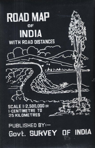
MAP OF INDIA
Road Map of India with Road Distances
Carte en couleurs , imprimée sur très bon papier collé sur tissu tramé , se repliant dans une pochette plastifiée . Echelle 1 cm pour 25 kilomètres . Tableau des distances entre les grandes villes . Pour voyager en Inde ou pour afficher au mur . Trés belle carte .- 1 p. , 600 gr.

|
|
|
MAP OF INDIA
Road Map of India with Road Distances
Gouvernement Survey of India 1977 150 Cm x 118 Cm Carte en couleurs , imprimée sur très bon papier collé sur tissu tramé , se repliant dans une pochette plastifiée . Echelle 1 cm pour 25 kilomètres . Tableau des distances entre les grandes villes . Pour voyager en Inde ou pour afficher au mur . Trés belle carte .- 1 p. , 600 gr.
Referentie van de boekhandelaar : 015281
|
|
|
Map. Florida. Cuba
Shell Map Of Florida And Cuba
Chicago: H. M. Gousha Company. Very Good. Measures approximately 18 x 29.5 inches 7 folds a few small breaks at folds. <br/><br/>With an inset map of Cuba. H. M. Gousha Company unknown
Referentie van de boekhandelaar : 4883
|
|
|
Map. Washington State
Highways State Of Washington
Olympia WA: Department of Highways 1937. Very Good. Measures approximately 19 x 27.5 inches 4 folds lightly edgeworn toned <br/><br/>The Washington State highway maps series began in 1933. Department of Highways unknown
Referentie van de boekhandelaar : 4884
|
|
|
MAPAS
MAPAS 1 Printed Textbook
Difusion 2022. Paperback. Very Good. . Sealed in publisher's shrink wrap. Splitting in shrink wrap so minor shelf wear may be present otherwise VG/NF. Unread clean. 12 month access code present. Difusion paperback
Referentie van de boekhandelaar : mon0002965477
|
|
|
MAPAS
MAPAS 2 Printed Textbook
Difusion 2022. Paperback. Very Good. . Sealed in publisher's shrink wrap never opened. 12 month access code included. Minor shelf wear minor splits in plastic may be present due to storage. Otherwise NF unopened/unread. Difusion paperback
Referentie van de boekhandelaar : mon0002965475
|
|
|
MAPAS
MAPAS 3 Printed Textbook
Klett World Languages 2022. Paperback. Very Good. . Sealed in publisher's shrink wrap never opened. Minor shelf wear may be present due to storage otherwise VG/NF. 12 month access code present. Klett World Languages paperback
Referentie van de boekhandelaar : mon0002965479
|
|
|
MAPAS
MAPAS 4 Printed Textbook
Klett World Languages 2022. Paperback. Very Good. . A nice clean copy unread. Minor shelf wear may be present due to storage. Otherwise VG/NF. Klett World Languages paperback
Referentie van de boekhandelaar : mon0002965531
|
|
|
MAPAS CARRETERA:
España centro. Madrid. Castilla-La Mancha. Extremadura. Ãndice de localidades. 1/400000 - 1 cm:4 km
.- Madrid. s. f. Michelin. 4º menor. Mapa plegado. Rústica editorial . Buen estado. . . ISBN 10: 2067004441. GeografÃa / Mapas CartografÃa paperback
Referentie van de boekhandelaar : *W119677 ISBN : 2067004441 9782067004443

|
|
|
Mapas Naturismo
Costa Rica r/v r naturismo
Mapas Naturismo 2014. Map. New. 2012 edition. 2 pages. 8.82x4.57x0.24 inches. Mapas Naturismo unknown
Referentie van de boekhandelaar : 1-3981126947 ISBN : 3981126947 9783981126945
|
|
|
Mapas Naturismo
Costa Rica Road Map Naturismo 1:500K English & Spainish
map. Good. Access codes and supplements are not guaranteed with used items. May be an ex-library book. unknown
Referentie van de boekhandelaar : 3981126947.G ISBN : 3981126947 9783981126945
|
|
|
Mapas Naturismo
Nicaragua Karte mapa de Tourismo 1:500.000english & espanol / Tourismus- und Straßenkarte""""
paperback. gebraucht sehr gut Originalbroschur Neu Verlagsfrisch. 90x68 cmbeidseitig . Mit Detailkarten von: -Rio San Juan 1:200.000 -Island Ometepe 1:200.000 -Delta RÃo San Juan 1:10.000 -Big and Little Corn Island 1:75.000 -und neu: zusätzlich: Isletas bei Granada 1:75.000 -zahlreiche Aktualisierungen an der Karibik Für Ihre Zufriedenheit versenden wir mit DHL und ausschließlich mit Trackingcode für eine sichere Sendungsverfolgung! Weitere Angebote unter antiquariat-kastanienhof paperback
Referentie van de boekhandelaar : B10625

|
|
|
MAPMEDIA.
Sokak sokak Ankara kent atlasi: 1/10.000.
Fine Turkish Paperback. Roy. 8vo. (24 x 17 cm). In Turkish. 224 p., plan, color ills. Sokak sokak Ankara kent atlasi: 1/10.000. Ankara city atlas (guide) street by street with a huge plan.
|
|
|
MAPS
BIRD'S EYE VIEW OF NARA
1900. MAPS. BIRD'S EYE VIEW OF NARA. Osaka: K. Kawakami c. 1900. Folding panorama c. 22" x 25" colored green and view. Some notes by contemporary tourist added to key. Heavily worn at folds and edges partly separated at folds. unknown books
Referentie van de boekhandelaar : 42458
|
|
|
maps
Etablissement Militaire de St. Bernard. Atlas des batiments
c. early 19th century. Hardcover. Very Good. Half cloth and marbled paper over boards handwritten label on upper board; oblong folio 460 x 360 mm; entirely handwritten and drawn in black ink on the rectos only with "tableau des batiments militaires" and 7 maps. Boards heavily scuffed; binding shaken; some dusty finger-smudges here and there. Sold as is. <br/><br/> hardcover
Referentie van de boekhandelaar : LD7400
|
|
|
maps
Etablissement Militaire de St. Bernard. Atlas des batiments
c. early 19th century. Hardcover. Very Good. Half cloth and marbled paper over boards handwritten label on upper board; oblong folio 460 x 360 mm; entirely handwritten and drawn in black ink on the rectos only with "tableau des batiments militaires" and 7 maps. Boards heavily scuffed; binding shaken; some dusty finger-smudges here and there. <br/><br/> hardcover books
Referentie van de boekhandelaar : LD7400
|
|
|
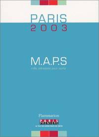
Maps
M.A.P.S. Paris 2003 : Mille adresses pour sortir
FLAMMARION 2003. Paperback. Very Good. Slight signs of wear on the cover. Edition 2003. Ammareal gives back up to 15% of this item's net price to charity organizations. FLAMMARION paperback
Referentie van de boekhandelaar : E-660-482 ISBN : 2080684442 9782080684448
|
|
|
MAPS
MAPS FOR THE JEWISH SCHOOL PORTFOLIO 1
1968. MAPS MAPS FOR THE JEWISH SCHOOL PORTFOLIO 1. New York: Jewish Education Committee Press January 1968. Ten color maps 9 1/2 x 14 inches plus bonus map of the Six Day War. Includes maps of ancient history and contemporary Israel as well as Eastern Europe. Maps fine original envelope has closed tears light soil. unknown books
Referentie van de boekhandelaar : 79979
|
|
|
Maps
Rand McNally Atlas of World History
Paperback. Very Good. paperback
Referentie van de boekhandelaar : GOR005107517 ISBN : 0528832883 9780528832888

|
|
 De zoekresultaten per email ontvangen
 Zoekresultaten downloaden als PDF
 RSS feed


