|
MONALDINI Venanzio (attivo 1765 - 1829 circa)
Vestigie di Roma Antica
Pianta a proiezione verticale, orografica, orientata con il nord in alto. Ristampa della pianta archeologica pubblicata nel 1819; nel cartiglio in basso a sinistra si legge, al luogo della dedica a papa Pio VII: "Pianta delle Vestigia di Roma secondo le osservazioni di Antonio de Romanis, arch. e socio dell' accad. di archeol. e di Antonio Nibby profess. di archeologia nell Vniv. di Roma e socio della stessa accademia dallo stesso corretta ed ampliata secondo le vltime scoperte. Data in luce da Venanzio Monaldini Libraio l'anno MDCCCXXVI".Pianta disegnata dagli archeologi Antonio De Romanis e Antonio Nibby, incisa da Giovanni Acquaroni per l'editore e committente Venanzio Monaldini.Come sottolinea Scaccia Scarafoni si tratta di un primo tentativo di riliebo scientifico dei soli ruderi allora conservati; intorno alla pianta sono diseganti i frammenti della Forma Urbis Severiana.Antonio de Romanis è un celebre architetto il cui nome è legato soprattutto al volume "Le antiche camere Esquiline dette comunemente delle Terme di Tito" del 1822, di fatto la prima relazione scientifica sugli ambienti della domus aurea in luce dopo gli scavi napoleonici.Antonio Nibby (Roma, 14 aprile 1792 – Roma, 29 dicembre 1839) è stato uno storico, archeologo e topografo italiano. Delle suddette discipline pose rigorosi fondamenti scientifici basandosi sull'analisi delle fonti classiche e medievali, lo studio dei monumenti e l'indagine diretta sul terreno. Fu studioso di topografia soprattutto di Roma antica e della Campagna Romana.Acquaforte, stampata su un grande foglio di carta coeva, con margini, in perfetto stato di conservazione. A vertical projection map, orographic, oriented with the north at the top. Reprint of the archaeological map published in 1819; in the cartouche at the bottom left we read, instead of the dedication to Pope Pius VII: "Pianta delle Vestigia di Roma secondo le osservazioni di Antonio de Romanis, arch. e socio dell' accad. di archeol. e di Antonio Nibby profess. di archeologia nell Vniv. di Roma e socio della stessa accademia dallo stesso corretta ed ampliata secondo le vltime scoperte. Data in luce da Venanzio Monaldini Libraio l'anno MDCCCXXVI".The map was drawn by the archaeologists Antonio De Romanis and Antonio Nibby, engraved by Giovanni Acquaroni for the publisher and customer Venanzio Monaldini.As Scaccia Scarafoni points out, this is a first attempt at scientific re-enactment of the only ruins then preserved; around the map are fragments of the Forma Urbis Severiana.Antonio de Romanis is a famous architect whose name is mainly linked to the volume "Le antiche camere Esquiline dette comunemente delle Terme di Tito" of 1822, in fact the first scientific report on the environments of the Domus Aurea after the Napoleonic excavations.Antonio Nibby (Rome, 14 April 1792 - Rome, 29 December 1839) was an Italian historian, archaeologist and topographer. He laid rigorous scientific foundations of the above mentioned disciplines based on the analysis of classical and medieval sources, the study of monuments and the direct investigation on the ground. He was a scholar of topography especially of ancient Rome and the Roman countryside.Etching, printed on a large sheet of contemporary paper, with margins, in perfect condition. Scaccia Scarafoni p. 46, n. 66.

|
|
|
MONMARCHE Marcel , sous La Direction
Bavière , Tirol , Bains De Bohème , Salzbourg , Vienne et Les Alpes Orientales
Collection " Les Guides Bleus " . Excursions , nombreux plans de voyage et de villes en couleurs et noir et blanc . Index . Avec 38 plans et 15 cartes .- 520 p. + plans , 550 gr.

|
|
|
MONMARCHE Marcel , sous La Direction , TILLION Mme E. L.
Belgique et Luxembourg
Collection " Les Guides Bleus " . Excursions , nombreux plans de voyage et de villes en couleurs et noir et blanc , certains dépliants . Complet de sa carte dépliante en fin d'ouvrage . Index .- 444 p. + plans , 550 gr.

|
|
|
MONMARCHE Marcel et MUIRHEAD Findlay
Les Guides Bleus : LONDRES et Ses Environs . Complet De Sa Carte Dépliante et De Ses Cartes En Couleurs .
Collection " Les Guides Bleus " . Excursions , nombreux plans de voyage et de villes en couleurs et noir et blanc . Une grande carte dépliante représentant Londres avant la 2° Guerre Mondiale . Index alphabérique . Les endroits et monuments visités sont entourés au crayon . Cartes et Plans .- 252 p. + plans , 400 gr.

|
|
|
MONT DORE. . .
Carte couleurs du Mont Dore au 1/40 000e. Sans date.
Une feuille 49x62 cm repli?e sous couverture.
|
|
|
Monteith, James Maps
Monteith's Physical and Political Geography -Edition for the Pacific Coast
New York Chicago and New Orleans: A S Barnes and Company 1866. Book. Illus. by Maps and Illustrations. Fair. Hardcover. 4to - over 9¾ - 12" tall. This is a well used book with the boards scuffed and worn and tape along the spine. There are several inserts of maps etc. including The Castle Line Map of South Africa. Has 112 pages plus a short section called Geography of the Pacific Slope. A S Barnes and Company Hardcover
Référence libraire : FRF315
|
|
|
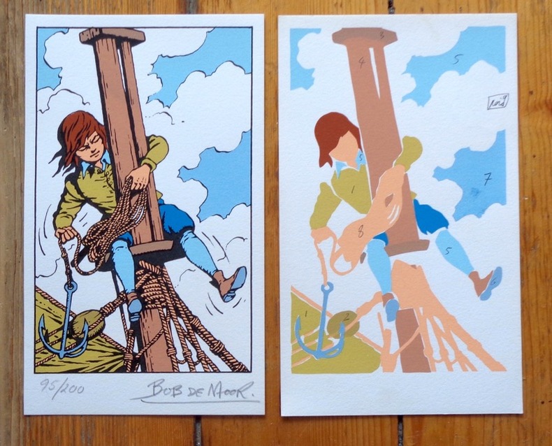
Moor Bob de:
Sérigraphie originale en 2 états.
Lausanne, La Marge. Sérigraphie au format 12 x 20 cm. En deux états, soit un essai des passages couleurs et la version définitive, au tirage limité à 200 exemplaires numérotés, la nôtre numéro 95.
Référence libraire : 6313
|
|
|
MOore, James
Sailing on Continental Lakes
No marks or inscriptions. Clean bright boards with no bumping to corners. Dust jacket not price clipped but crease on dust flap. A clean tight copy. Light foxing to page edges and end papers. 204pp. A scarce book. A complete guide to lake holidays on 30 of the large and small lakes in Switzerland, Germany and Austria.

|
|
|
Moore, W. G.
A Dictionary of Geography: Definitions and Explanations of Terms Used in Physical Geography
184 pages, illustrated, page edges browned, covers detached, spine faded, (Penguin Reference Books ; R2). eng
|
|
|
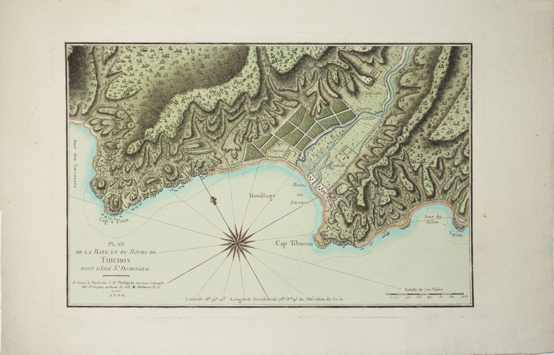
MOREAU DE SAINT-MERY (Médéric-Louis-Elie).
[HAITI] Plan de la baye et du bourg de Tiburon dans l'isle St. Domingue.
Paris, Sr. Phélipeau, 1786 [1791]. 242 x 371 mm.
Référence libraire : LBW024a1
|
|
|
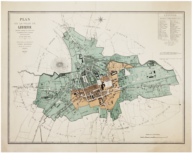
MORIÈRE (Émile).
[LISIEUX] Plan de la ville de Lisieux dressé d'après le cadastre et d'après les plans d'annexion prononcée par décret du 24 mars 1875.
Lisieux, Émile Morière, 1899. 502 x 663 mm.
Référence libraire : LBW-6309
|
|
|
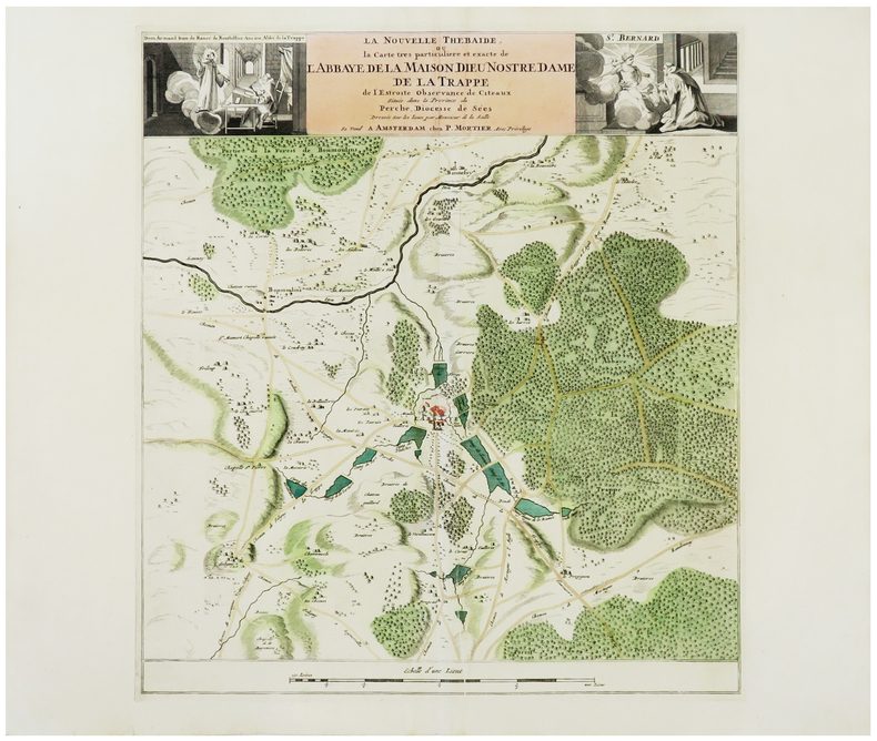
MORTIER (Pierre).
[NORMANDIE/LA TRAPPE] La nouvelle Thébaïde, ou la carte très particulière et exacte de l'abbaye de la Maison Dieu Nostre Dame de La Trappe de l'Estroite Observance de Citeaux située dans la province du Perche, diocesse de Sées.
Amsterdam, P. Mortier, [1705]. 468 x 422 mm.
Référence libraire : LBW-6243
|
|
|
MORIN (Jorj).
[ROUEN] Rouen. Le port, les industries - Port and industry - Haven und Industrie - Puerto y industrias.
Paris, R. Autrive, [vers 1965]. 0,79 x 1,21 m.
Référence libraire : LBW-8623

|
|
|
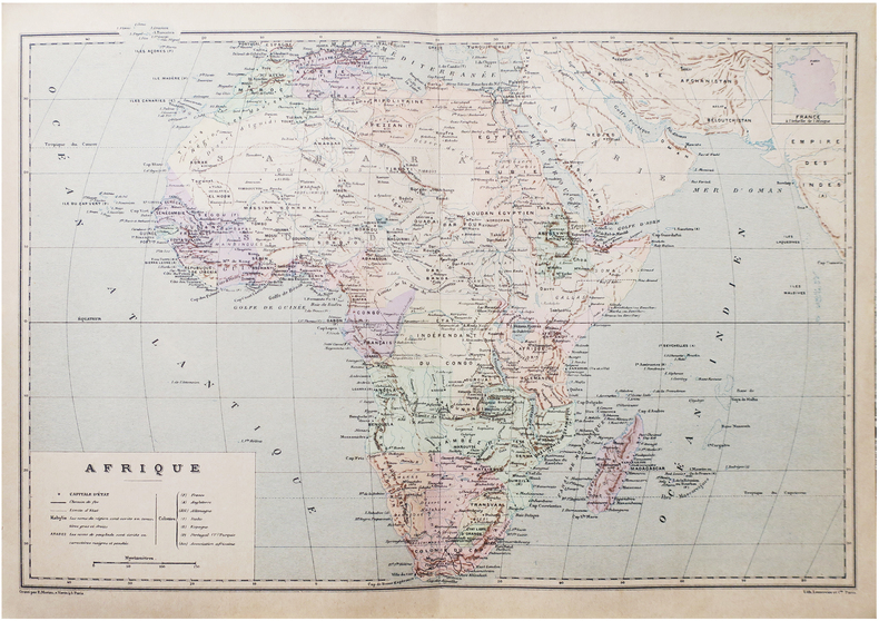
MORIEU (Émile).
Afrique.
Paris, [1890]. 275 x 405 mm.
Référence libraire : LBW-8651
|
|
|
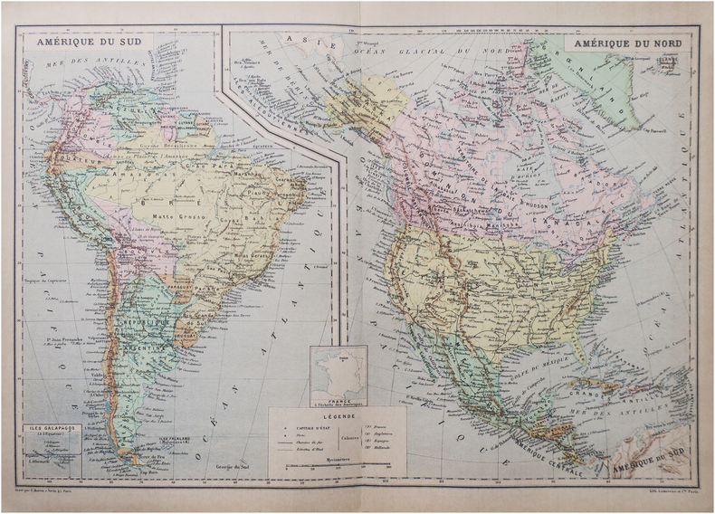
MORIEU (Émile).
Amérique du Sud - Amérique du Nord.
Paris, [1890]. 272 x 404 mm.
Référence libraire : LBW-8654
|
|
|
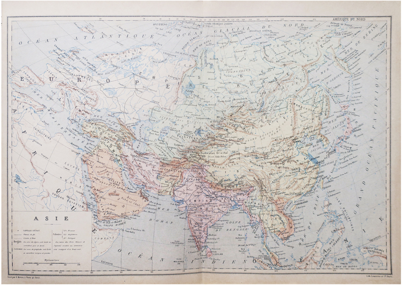
MORIEU (Émile).
Asie.
Paris, [1890]. 274 x 407 mm.
Référence libraire : LBW-8643
|
|
|
MORAND P.-H.
Comment faire les réussites. 50 réussites différentes.
broché - 10x15 - 112 pp - 1928 - librairie BERNARDIN-BECHET, Paris. Illustrations hors texte.
Référence libraire : 7209
|
|
|
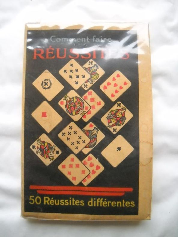
MORAND (P.-H.).
Comment faire les réussites - 50 réussites différentes.
Paris, Librairie Bernardin-Béchet, s.d. [circa 1950]. Un vol. au format in-16 (152 x 98 mm) de 111 pp. Reliure postérieure de demi-chagrin glacé havane, filet vertical à froid porté sur les plats, dos à nerfs orné de filets gras à froid, titre doré, premier plat de couverture conservé.
Référence libraire : 22450
|
|
|
Mordal Jacques - illustrations en couleurs G. de Sainte-Croix - cartes et silhouettes de Roseline Cras
Histoires de la flotte française de combat
Casablanca Publedit 1959 - in-8 - Reliure éditeur, avec jaquette illustrée - 445pages illustrations en couleurs G. de Sainte-Croix, cartes et silhouettes de Roseline Cras - Jaquette défraichie sinon très frais intérieurement - Envoi rapide et soigné
Référence libraire : 3147
|
|
|
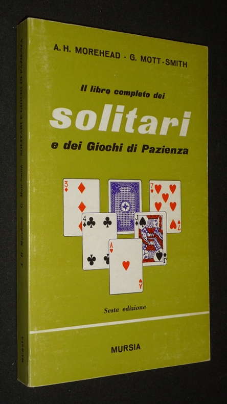
Morehead A. H.,Mott-Smith G.
Il libro completo dei solitari e dei giochi di pazienza
Mursia Dos carré collé 1975 In-8 (11,5 x 19 cm), dos carré collé, 223 pages, texte en italien ; marques de frottement au premier plat, traces au dos et quatrième plat, assez bon état général. Livraison a domicile (La Poste) ou en Mondial Relay sur simple demande.
Référence libraire : vb1767
|
|
|
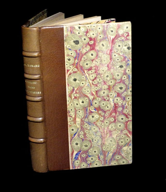
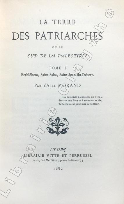
Morand (Abbé Louis) :
La Terre des Patriarches ou le sud de la Palestine.
Lyon, Vitte et Perrussel, (imprimerie Alf. Louis Perrin), 1882-1883 ; 2 tomes in-16 (184 mm), brochés ; XXV, 414, [1] marque d'imprimeur ; XII, 213 pp., 3 planches hors texte dont 2 dépliantes (plans et carte) ; couverture gris-bleu.
Référence libraire : 21824
|
|
|
MORGAN Jacques de:
La préhistoire orientale.
Paris, Lib. orientaliste Paul Geuthner, 1925. 3 tomes en 1 vol. in-8 de XXXV-332-[2]-VI-438-VI-458 pages, reliure moderne pleine percaline bleue nuit, couverture conservée.
Référence libraire : 1591

|
|
|
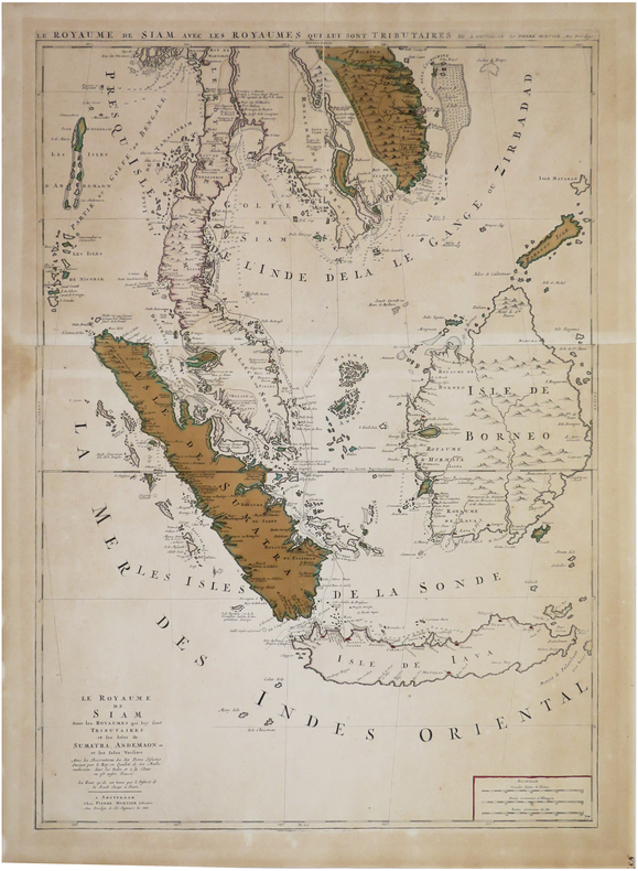
MORTIER (Pierre).
Le Royaume de Siam avec les royaumes qui luy sont tributaires, et les isles de Sumatra, Andemaon, etc. et les isles voisine.
Amsterdam, Pierre Mortier, [circa 1700]. En deux feuilles jointes formant une carte de 785 x 558 mm.
Référence libraire : LBW-8119
|
|
|
MORIEU (Émile).
Océanie.
Paris, [1890]. 271 x 404 mm.
Référence libraire : LBW-8650
|
|
|
Morton-Cameron, W H [Compiler]; Feldwick, W [Editor-in-Chief]
Present Day Impressions of the Far East and Prominent & Progressive Chinese at Home and Abroad.
London Shangai Hongkong Saigon Singapore Batavia The Globe Encyclopedia Company 1917 Reliure de l'éditeur
Référence libraire : 015854
|
|
|
MORA P. E.
Tous les jeux de cartes et leurs règles.
Paris, Bornemann, Ulisse Editions, 1995. 15 x 21, 132 pp., quelques illustrations, broché, très bon état.
Référence libraire : 98586 ISBN : 285182516
|
|
|
MOrath, Inge and Miller, Arthur
Chinese Encounters
Slight discoloration to corner of ffep. No other marks or inscriptions. Dust jacket price clipped and with a number of small tears to the edges. A clean tight copy. 255pp.

|
|
|
MORBIHAN. . .
Carte d?partementale couleurs. Sans date.
Une feuille 76x56 cm repli?e sous couverture.
|
|
|
MORBIHAN...
Carte du d?partement du Morbihan. Petit Atlas National. Sans date.
Carte 25x32 cm. Quelques rousseurs
|
|
|
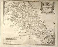
MORDEN ROBERT.
Northhampton Shire
London.: Gibson. Early 18th Century. Engraved map on watermarked paper central fold 38 x 46.5 cm decorative title cartouche towns roads rivers and landforms shown; from Gibson's edition of Camden's Britannia upper edge trimmed by the original binder causing minor loss to the border at the inner edge but in very good condition. . [Gibson.] unknown
Référence libraire : 64139
|
|
|
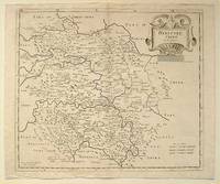
MORDEN, ROBERT.
Hereford Shire
London.: Gibson. Early 18th Century. Black and white map from Camden's Britannia showing towns roads rivers and landforms 38 x 46.5 cm. . [Gibson.] unknown
Référence libraire : 64216
|
|
|
Morison, Samuel Eliot and photos/maps
SICILY-SALERNO-ANZIO January 1943-June 1944: Volume IX; History of United States Naval Operations in World War II.
Hardcover. Fine. hardcover
Référence libraire : PM-OHYG-RHJH
|
|
|
Morningstar, C.K.; Corfield, William E. (editor)
From Dobbin to Diesel - The Story of Public Transportation in London, Canada
53 pages. The London Street Railway received its charter in 1873 and commenced service in 1875. This work commemorates a century of planning and service. Author retired as General Manager of the service in 1971 and completed two years of research in preparation for this work. Prepared from the files of the London Street Railway Company and its successor, the London Transportation Commission, from newspaper stories, memories of veteran employees, and many other sources. "Includes a brief outline of London from its beginning as a pioneer settlement in 1826 to 1875 when public transportation commenced, because the story of horse-drawn trams, electric street cars and buses is really part of the story of our community and the people who built it over the years." - from Foreward. Includes numerous black and white illustrations and maps. Tiny prior owner's address label inside front board else clean, bright and unmarked with negligible wear. Beautiful copy. Book

|
|
|
Morris, Donald R. [maps, Rafael Palacios
The Washing of the Spears : a History of the Rise of the Zulu Nation under Shaka and its Fall in the Zulu War of 1879. The Bantu; Port Natal; Dingane; Mpande; Isandhlwana; Defense of Rorke's Drift; Ulundi; etc
New York : Konecky & Konecky 1965. 1965. Very Good. 655 p. : ill. maps ; 24 cm. ; ISBN: 1568520271 ; OCLC: 32905083 ; grey textured cloth with gold lettering in colorful dustjacket ; spot on front cover ; spine creased else VG/VG New York : Konecky & Konecky, 1965. hardcover
Référence libraire : 2712 ISBN : 1568520271 9781568520278

|
|
|
Morris, Jan
Sydney
No inscriptions or marks. No creasing to covers or to spine. A very clean very tight copy with bright unmarked boards and no bumping to corners. 246pp.

|
|
|
Morris, John G.
MARTIN BEHAIM, THE GERMAN ASTRONOMER AND COSMOGRAPHER OF THE TIMES OF COLUMBUS: Being the Tenth Annual Discourse Before the Maryland Historical Society, On January 25th, 1855.
48 p. Title page printed in red and black with Maryland Historical Society's device. 230mm. Original printed wraps. Lacks rear wrap. Front wrap soiled. Early inked ownership of W. Frederick Frick on front wrap. Scarce original edition. **PRICE JUST REDUCED! SCIENCE BX 3
|
|
|
Morris, Ric/ A-Z Maps
A -Z Brighton Hidden Walks: Discover 20 routes in and around the city
Geographers’ A-Z Map Co Ltd 2023. Paperback. New. 128 pages. 7.09x4.92x0.32 inches. Geographers’ A-Z Map Co Ltd paperback
Référence libraire : __0008564957 ISBN : 0008564957 9780008564957

|
|
|
Morschner und Jasper
Mappa topografica di Vienna / Wien Plan / Plan de Vienne / Stadtplan Wien
Grande carta topografica (cm. 93 x 104) della città di Vienna: quartieri e monumenti sono colorati con il rimando alla legenda.
|
|
|
Morse Jedidiah and Rev. Elijah Parish; 17 folding maps as called for Illustrator
A new gazetteer of the Eastern continent : or A geographical dictionary ; containing in alphabetical order a description of all the countries kingdoms states cities towns principal rivers lakes harbours mountains &c. &c. in Europe Asia Africa and their adjacent islands
imprint of Samuel Etheridge 1802-01-01. Leather Bound. Good. Bound in contemporary full calf. Gilt ruled red leather spine label. Wear rubbing to cover. Solid binding. 712 pages 18 pages of plates : illustrations 17 folded maps ; 23 cm. Intended as the second volume to the American Gazetteer. Scattered foxing. imprint of Samuel Etheridge hardcover
Référence libraire : 1610270044

|
|
|
Morse, Jedidiah (1761-1826).
AN ABRIDGMENT OF THE AMERICAN GAZETTEER: Exhibiting, In Alphabetical Order: A Compendious Account Of States, Provinces, Counties, Cities, Rivers, Bays, Harbours. On The American Continent, And Its Appendant Islands; Particularly The West Indies.
388 p. + Folding Map of North America. Offsetting from map on title page. Text browning but not brittle. Page 145 slightly torn without loss. Page 183 loss in margin and very slight loss of text. Mildly XLib. Bookplate of American Philosophical Society of Philadelphia, presented by John Vaugham. 175 mm. Disbound. Signatures loose. Should be rebound. First Edition in this form. Abridged by the Author. Title continues: "To Which Is Annexed An Accurate Table Of All The Post-Offices In The United States." Hardbound. The map alone usually brings this price. AI BX 4
|
|
|
MORTIER Pierre (1661 - 1711)
Roma Vetus - Rome Ancienne
Pianta di Roma antica, orientata con il nord a sinistra."A proiezione obliqua; orografica. Veduta a volo d'uccello con la raffigurazione dei soli edifici e monumenti pubblici principali, rappresentati in alzato" (cfr. Scaccia Scarafoni p. 36).La mappa deriva da quella di Johannes Blaeu del 1663, della quale è una perfetta riedizione, non derivante dalla stessa lastra: "Quella del Mortier non è dunque un ristampa della precedente del 1663, come si legge in qualche repertorio, ma una perfetta riedizione […] lo dimostrano alcune varianti, il titolo in latino al centro in alto rialzato per far posto alla sottostante traduzione in francese, i toponimi interamente riscritti e leggermente più grandi dell'originale, soprattutto la scomparsa del ricco stemma del nobile Simone van Hoorn e del cartiglio con la dedica allo stesso, a firma del Blaeu" (cfr. Caldana, p. 98).Opera tratta dal terzo volume del Nouveau Theatre de l’Italie.Acquaforte, con margini, in perfetto stato di conservazione. Map of ancient Rome, oriented with the north to the left."A proiezione obliqua; orografica. Veduta a volo d'uccello con la raffigurazione dei soli edifici e monumenti pubblici principali, rappresentati in alzato" (cfr. Scaccia Scarafoni p. 36).The map derives from Johannes Blaeu's map of 1663, of which it is a perfect re-edition, nor derived from the same plate: "Mortier's map is therefore not a reprint of the previous one of 1663, as we read in some repertoire, but a perfect re-edition [...] this is demonstrated by some variations, the Latin title in the center at the top raised to make way for the underlying French translation, the place names entirely rewritten and slightly larger than the original, especially the disappearance of the coat of arms of the noble Simone van Hoorn and the cartouche with the dedication signed by Blaeu" (cf. Caldana, p. 98).Work taken from the third volume of the Nouveau Theatre de l'Italie.Etching, with margins, in perfect condition. Caldana, "Roma Antica", 2013, p. 98, n. I.45; Scaccia Scarafoni, "Le Piante di Roma", n. 36.

|
|
|
Morton, H V
The Magic of Ireland
No marks or inscriptions. No creasing to covers, minor crease partway down spine. A clean very tight copy with lightly sunned covers and no bumping to corners. Minor bump to bottom of spine. 160pp. This volume presents selections of the text from Morton's classic 'In Search of Ireland' dated 1930 complemented with a wealth of colour and monochrome photographs of modern Ireland.

|
|
|
MOSCHETTI Alessandro (attivo tra il 1830 e il 1845)
Pianta di Roma Elevata nel MDCCCXLVIII
Pianta di Roma edita da Alessandro Moschetti nel 1848. Viene attribuita ad Angelo Bertini – in qualità di editore – ed Enrico Salandri come incisore. “è la seconda edizione della pianta del Bertini/Salandri. Attorno alla pianta ci sono sei vedutine di Roma e 117 numeri di legenda come nella prima edizione. Le varie ristampe, come rilevato dal Frutaz, si differenziano tra loro solo per alcuni particolari dell’apparato decorativo estreno. Il prototipo di questa pianta dovrebbe essere quella di anonimo del 1820 circa, in cui piazza del Popolo si presenta ancora con un solo emiciclo realizzato. I nomi del Bertini e del Salandri sono presenti solo nella prima edizione” (cfr. Marigliani p. 363). Alessandro Moschetti, secondo quanto si legge in Giovanna Sapori e Sonia Amadio, Il mercato delle stampe a Roma, XVI-XIX secolo (p. 334) fu incisore di architetture con bottega a Roma in via Bocca di Leone, 63. Secondo altre fonti fu invece attivo a Roma prima e Napoli poi fino al 1868. Si dedicò con successo all’intaglio di vedute della città eterna, pubblicate per la prima volta nella Raccolta delle principali vedute di Roma antica e moderna (1843). La raccolta, che comprende un frontespizio figurato e 35 tavole incise in rame dal Moschetti su disegni di Marchi, Ciconnetti e Zolla, "il cui numero può variare da un esemplare all'altro" (cfr. S. Rossetti, n. 7252) è assai ricercata per la pianta di Roma nel 1843 e soprattutto per le vedute arricchite di scene popolari tipiche del folclore civile e religioso dell'epoca. Successivamente le vedute di Moschetti furono ristampate, in numero sempre crescente. Il presente esemplare è tratto dalle 70 Principali vedute di Roma 1861. Proprietà Cesari, reperibile in via Petra n.89. Scudi 6. Incisione in rame, in ottimo stato di conservazione. Bibliografia Cfr. Marigliani, Le piante di Roma nelle collezioni private (2007), p. 363, n. 297; Frutaz n. 199; Scaccia Scarafoni n. 298. Map of Rome edited by Alessandro Moschetti in 1848. It is attributed to Angelo Bertini -as publisher - and Enrico Salandri, as engraver. “è la seconda edizione della pianta del Bertini/Salandri. Attorno alla pianta ci sono sei vedutine di Roma e 117 numeri di legenda come nella prima edizione. Le varie ristampe, come rilevato dal Frutaz, si differenziano tra loro solo per alcuni particolari dell’apparato decorativo estreno. Il prototipo di questa pianta dovrebbe essere quella di anonimo del 1820 circa, in cui piazza del Popolo si presenta ancora con un solo emiciclo realizzato. I nomi del Bertini e del Salandri sono presenti solo nella prima edizione” (cfr. Marigliani p. 363). Alessandro Moschetti, according to Giovanna Sapori and Sonia Amadio, Il mercato delle stampe a Roma, XVI-XIX secolo (p. 334) was an engraver of architecture with a workshop in Rome at Via Bocca di Leone, 63. According to other sources, he was active first in Rome and then in Naples until 1868. He devoted himself successfully to the engraving of views of the Eternal City, published for the first time in the Raccolta delle principali vedute di Roma antica e moderna (1843). The collection, which includes an illustrated frontispiece and 35 plates engraved in copper by Moschetti on drawings by Marchi, Ciconnetti and Zolla, "the number of which may vary from one copy to another" (cf. S. Rossetti, n. 7252) is much sought after for the plan of Rome in 1843 and especially for the views enriched with popular scenes typical of the civil and religious folklore of the time. Subsequently, Moschetti's views were reprinted in increasing numbers. The present example is taken from the 70 Principal Views of Rome 1861. Copper engraving, in excellent condition. Bibliografia Cfr. Marigliani, Le piante di Roma nelle collezioni private (2007), p. 363, n. 297; Frutaz n. 199; Scaccia Scarafoni n. 298.

|
|
|
Mosel, Wilhelm (Bearb.)
Wegweiser zu ehemaligen jüdischen Stätten Leidensstätten der Deportation von Hamburg nach Minsk. Hrsg. v. der Deutsch-Jüdischen Gesellschaft.
Hamburg, 1995. 99 S. Mit s/w-Abb. (= Schriftenreihen der Deutsch-Jüdischen Gesellschaft (DJG) Hamburg., Reihe 2, Heft 2). Gr.-8vo. OBrosch.
Référence libraire : 39156

|
|
|
MOSELLE
Bassin houiller de Lorraine. Documents cartographiques du sch?ma directeur d'am?nagement et d'urbanisme.
Broch?. 119 cartes 21x30 cm.
|
|
|
MOTA, Avelino Teixeira da.
O Cosmógrafo Bartolomeu Velho em Espanha.
Coimbra, Junta de Investigações do Ultramar, 1966. Folio; 27 pp. Cubiertas mudas en papel.

|
|
|
Mott, Michael, 1930- ; Merton, Thomas, 1915-1968 [art, Victor Hammer; photo, Thomas Lyman; maps, Amanda Mott; excerpts, Robert
The Seven Mountains of Thomas Merton. Continuing conversion continuing autobiography. -- Canigou. -- The Calvaire. -- Brooke Hill. -- The pasture Merton's heart. -- Mount Purgatory. -- Mount Olivet. -- Kanchenjunga
Boston : Houghton Mifflin 1984. 1984. 1st Edition 4th Printing. Hardcover. Fine/Very Good. 4th printing ; xxvi 690 pp. 16 pp. of plates ; illustrated portraits ; 24 cm. ; ISBN: 0395313244 :; 9780395313244 LCCN: 84-10944 ; LC: BX4705.M542; Dewey: 271/.125/024 ; OCLC: 10875978 ; purple and white cloth with metallic purple lettering in purple white and gold dustjacket ; the first authoritative life of Thomas Merton to appear in print ; important resource ; FINE/VG <br/> <br/> Boston : Houghton Mifflin, 1984. hardcover
Référence libraire : 008418 ISBN : 0395313244 9780395313244

|
|
|
Mouvement du 22 mars.
Chez Renault, à Flins, les CRS ont envahi l'usine. Les grévistes demandent de l'aide.
Nanterre Mouvement du 22 mars 1968 1 vol. en feuilles Court tract dactylographié sur papier rose, signé du Mouvement du 22 mars et appelant à la manifestation à prêter main forte aux ouvriers grévistes de l'usine de Flins. Un peu froissé.
Référence libraire : 93122
|
|
|
MOULLART-SANSON (Pierre).
Hémisphère occidental du globe terrestre veu en concave [et] Hémisphère oriental du globe terrestre veu en concave.
Paris, aux Galleries du Louvre vis à vis St. Nicolas avec priv., [1710]. 335 x 585 mm.
Référence libraire : LBW-7241

|
|
 Recevoir par e-mail
 Télécharger en PDF
 Flux RSS


