National Geographic Maps. New. BRAND NEW GIFT QUALITY! NOT OVERSTOCKS OR MARKED UP REMAINDERS! DIRECT FROM THE PUBLISHER! National Geographic Maps unknown
Riferimento per il libraio : OTF-S-9781597756198 ISBN : 1597756199 9781597756198
National Geographic Maps 2023. Unbound. Good. Missing dust jacket; Pages can have notes/highlighting. Spine may show signs of wear. ~ ThriftBooks: Read More Spend Less.Dust jacket quality is not guaranteed. National Geographic Maps unknown
Riferimento per il libraio : G1597752061I3N01 ISBN : 1597752061 9781597752060
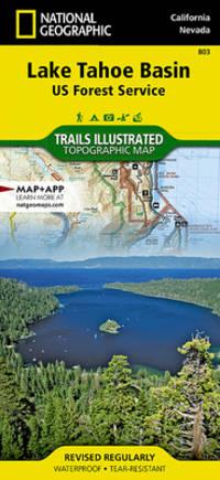
Trails are classified by use - hiking horse and hike mountain bike shared use or motorized - and includes a trail chart showing trail name location and allowed use. Trail mileage private land designation and information on general regulations safety Desolation Wilderness camping fishing and snow parks round out the usefulness of this map. It also includes bathymetric shading of the Lake Tahoe. Coverage includes Lake Tahoe Basin Management Unit Eldorado Humboldt-Toiyabe and Tahoe national forests. Desolation Granite Chief and Mt. Rose Wilderness Areas. Pacific Crest National Scenic Trail. Tahoe Rim Trail. Rubicon OHV Trail. Emerald Bay D.L. Bliss Ed Z'Berg Sugar Pine Burton Creek Donner Memorial Lake Tahoe Nevada and Washoe Lake state parks. Mt. Tallac Echo Summit Carson Pass Spooner Summit Mt. Rose Summit Brockway Summit. Towns: Truckee Tahoe City Homewood Tahoma South Lake Tahoe Zephyr Cove Incline Village Kings Beach Carson City. Includes UTM grids for use with your GPS unit and a trail mileage matrix. unknown
Riferimento per il libraio : BIBUP61025-A31493 ISBN : 1566953340 9781566953344
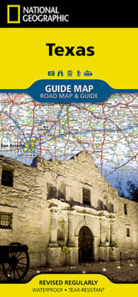
- Waterproof - Tear-Resistant - Travel Map Expertly researched and loaded with helpful information National Geographic's Texas Guide Map is a must-have for travelers exploring ""The Lone Star State."" In addition to a state map inset maps provide detail on the Texas Panhandle and the cities of Dallas Fort Worth Houston Amarillo Abilene Lubbock Waco Laredo Beaumont El Paso Odessa-Midland McAllen Corpus Christi San Antonio and Austin. Cities and towns are easy to find with the map's helpful index and hundreds of attractions are noted. Road network designations are clear and distances in miles on major highways are shown. Additional information and maps feature the recreation activities available in Big Bend National Park and the attractions along the Hill Country scenic drive. The Alamo the Space Center Houston the San Antonio Riverwalk and Guadalupe Mountains National Park are just some of the many points of interest that are highlighted. A handy chart of park service sites and climate information are also included. Every State Guide Map is printed on durable synthetic paper making them waterproof tear-resistant and tough -- capable of withstanding the rigors of any kind of travel. Map Scale = 1:31680000 Sheet Size = 24.75"" x 17.75"" Folded Size = 4"" x 8.75"" unknown
Riferimento per il libraio : BIBUP61025-A19915 ISBN : 156695729X 9781566957298
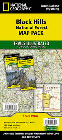
Waterproof Tear-Resistant Travel MapThe Black Hills National Forest Map Pack Bundle is the perfect companion for anyone planning a trip to the Black Hills of South Dakota. The two maps in this Map Pack Bundle cover the Black Hills National Forest in great detail and include all of the information needed for a memorable trip for the first time or the frequent visitor. The maps include trails with mileage between intersections numbered US Forest Service roads motorized trails as well as hundreds of points of interest such as campgrounds trail heads and boat ramps. ""Buy the Map Pack and save 15%!"" The Black Hills National Forest Map Pack includes: Map 238:: Black Hills South Black Hills National ForestMap 751:: Black Hills North Black Hills National ForestEvery Trails Illustrated map is printed on ""Backcountry Tough"" waterproof tear-resistant paper. A full UTM grid is printed on the map to aid with GPS navigation.""Map Scale = 1:70000Sheet Size = 37.75"" x 25.5""Folded Size = 4.25"" x 9.25"""""" unknown
Riferimento per il libraio : BIBUP61025-A51244 ISBN : 159775398X 9781597753982
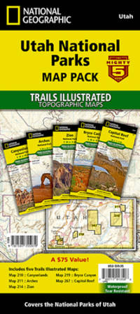
Waterproof Tear-Resistant Topographic Map The five iconic national parks in the high desert of Utah are all provided in this single easy to purchase product. You get the maps for the best road trip of your life all while saving over 15%. Like all Trails Illustrated maps the Utah National Parks Bundle set is frequently revised and printed on waterproof tear-resistant material to stand up to all conditions. This detailed topographic recreation map bundle contains carefully researched trails campsites forest service roads and points-of-interests. Includes UTM grids for use with your GPS unit. Coverage includes the The Mighty 5 national parks of Utah: Arches Bryce Canyon Canyonlands Capitol Reef and Zion National Parks.""Map Scale = 1:35000 & 1:75000Sheet Size = 37.75"" x 25.5""Folded Size = 4.25"" x 9.25"""""" unknown
Riferimento per il libraio : BIBUP61025-A55528 ISBN : 1597755974 9781597755979
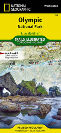
• Waterproof • Tear-Resistant • Topographic Map Within the park there is detailed coverage of Mount Olympus Tshletshy Ridge Hurrican Ridge Huelsdonk Ridge Bailey Range camping areas facilities ranger stations nature trails waterfalls boat launches and much more. Also included are the Mount Skokomish Wilderness Ozette Lake Lake Pleasant Lake Crescent Lake Mills and Olympic National Forest. The map is full of detailed trail information points of interest trailheads picnic areas facitlities and more. Includes UTM grids for use with your GPS unit. Sheet Size = 25.50 x 37.75 Folded Size = 4.25 x 9.25 Scale = 1:100000 unknown
Riferimento per il libraio : BIBUP61025-A23283 ISBN : 1566954029 9781566954020
 Ricevere i risultati per e-mail
 Scaricare i risultati in PDF
 RSS feed