|
National Geographic Maps - Adventure
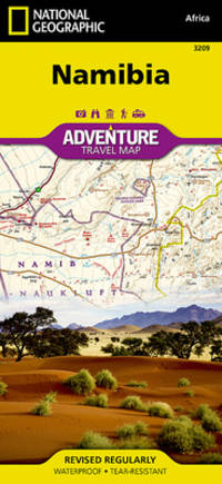
Namibia Map National Geographic Adventure Map 3209
Natl Geographic Society Maps. New. Special order direct from the distributor Natl Geographic Society Maps unknown
书商的参考编号 : ING9781597756198 ???????? : 1597756199 9781597756198
|
|
|
National Geographic Maps - Adventure
Namibia National Geographic Adventure Map
National Geographic Maps. New. BRAND NEW GIFT QUALITY! NOT OVERSTOCKS OR MARKED UP REMAINDERS! DIRECT FROM THE PUBLISHER! National Geographic Maps unknown
书商的参考编号 : OTF-S-9781597756198 ???????? : 1597756199 9781597756198
|
|
|
National Geographic Maps Trails Illustrated
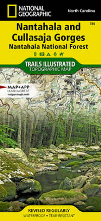
Nantahala and Cullasaja Gorges Map Nantahala National Forest National Geographic Trails Illustrated Map 785
map. Good. Access codes and supplements are not guaranteed with used items. May be an ex-library book. unknown
书商的参考编号 : 156695312X.G ???????? : 156695312X 9781566953122
|
|
|
National Geographic Maps Trails Illustrated
Nantahala and Cullasaja Gorges Map Nantahala National Forest National Geographic Trails Illustrated Map 785
National Geographic 2020-01-01. 2020. map. New. 4.20x0.20x8.90. Buy with confidence. Excellent Customer Service & Return policy. National Geographic unknown
书商的参考编号 : DADAX156695312X ???????? : 156695312X 9781566953122
|
|
|
National Geographic Maps Trails Illustrated
Nantahala and Cullasaja Gorges Map Nantahala National Forest National Geographic Trails Illustrated Map 785
National Geographic 2020-01-01. 2020. map. Used: Good. 4.20x0.20x8.90. Buy with confidence. Excellent Customer Service & Return policy. National Geographic unknown
书商的参考编号 : SONG156695312X ???????? : 156695312X 9781566953122
|
|
|
National Geographic Maps
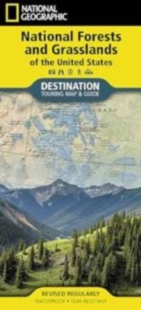
National Forests and Grasslands of the United States Map
Sheet map folded. New. New Book; Fast Shipping from UK; Not signed; Not First Edition; Waterproof Tear-Resistant Travel Map. unknown
书商的参考编号 : ria9781566959407_inp ???????? : 1566959403 9781566959407
|
|
|
National Geographic Maps
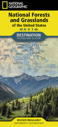
National Forests and Grasslands of the United States Map National Geographic Destination Map
map. Good. Access codes and supplements are not guaranteed with used items. May be an ex-library book. unknown
书商的参考编号 : 1566959403.G ???????? : 1566959403 9781566959407
|
|
|
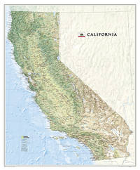
National Geographic Maps - Reference
National Geographic California Wall Map - Laminated 33.5 x 40.5 in National Geographic Reference Map
National Geographic 2023-08-15. 2023. map. Used: Good. 3.25x3.25x43.25. Buy with confidence. Excellent Customer Service & Return policy. National Geographic unknown
书商的参考编号 : SONG1597752061 ???????? : 1597752061 9781597752060
|
|
|
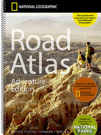
National Geographic Maps
National Geographic Road Atlas 2026: Adventure Edition United States Canada Mexico
National Geographic Maps 2025-07-11. spiral_bound. New. 11x0x15. Ship within 24hrs. 100% Satisfaction is Our #1 Goal! National Geographic Maps unknown
书商的参考编号 : 3F5-00001 ???????? : 0792289897 9780792289890
|
|
|
National Geographic Maps - Reference
National Geographic United States for Kids Wall Map - Laminated Poster Size: 36 x 24 in National Geographic Reference Map
NEW. unknown
书商的参考编号 : BIB-NOV-14-2025-47585
|
|
|
National Geographic Maps
National Geographic Railroad Legacy Map of the United States Wall Map Poster Size: 36 x 24 in National Geographic Reference Map
NEW. unknown
书商的参考编号 : BIB-NOV-14-2025-25569 ???????? : 1566958156 9781566958158
|
|
|
National Geographic Maps - Reference
National Geographic Shipwrecks of Delmarva Wall Map - Laminated 28 x 35 in National Geographic Reference Map
NEW. unknown
书商的参考编号 : BIB-NOV-14-2025-72689
|
|
|
National Geographic Maps - Reference
National Geographic Colorado Trail Wall Map - Laminated 18 x 48 in National Geographic Reference Map
NEW. unknown
书商的参考编号 : BIB-NOV-14-2025-192477
|
|
|
National Geographic Maps
National Geographic United States for Kids in gift box Wall Map Poster Size: 36 x 24 in National Geographic Reference Map
NEW. unknown
书商的参考编号 : BIB-NOV-14-2025-148670 ???????? : 159775630x 9781597756303
|
|
|
National Geographic Maps - Reference
National Geographic World Physical Wall Map - Laminated Enlarged: 69.25 x 46.25 in National Geographic Reference Map
NEW. unknown
书商的参考编号 : BIB-NOV-14-2025-215127
|
|
|
National Geographic Maps - Reference
National Geographic: World and United States Coloring Maps Map Pack Bundle National Geographic Reference Map
NEW. unknown
书商的参考编号 : BIB-NOV-14-2025-200703
|
|
|
National Geographic Maps
National Geographic World Pacific Centered Wall Map - Classic Enlarged: 73 x 48 in National Geographic Reference Map
NEW. unknown
书商的参考编号 : BIB-NOV-14-2025-387241
|
|
|
National Geographic Maps
National Geographic World and United States Maps - Executive Poster Size: 36 x 24 in Map Pack Bundle National Geographic Reference Map
NEW. unknown
书商的参考编号 : BIB-NOV-14-2025-400609
|
|
|
National Geographic Maps
National Geographic Universe Wall Map 31.25 x 20.25 in National Geographic Reference Map
NEW. unknown
书商的参考编号 : BIB-NOV-15-2025-66179
|
|
|
National Geographic Maps
National Geographic World Physical Wall Map Enlarged: 69.25 x 46.25 in National Geographic Reference Map
NEW. unknown
书商的参考编号 : BIB-NOV-15-2025-170868
|
|
|
National Geographic Maps Reference
National Geographic Maine Wall Map - Laminated 30.25 x 40.5 in National Geographic Reference Map
NEW. unknown
书商的参考编号 : BIB-NOV-15-2025-107662
|
|
|
National Geographic Maps - Reference
National Geographic Cuba Wall Map - Classic - Laminated Poster Size: 36 x 24 in National Geographic Reference Map
NEW. unknown
书商的参考编号 : BIB-NOV-15-2025-569585
|
|
|
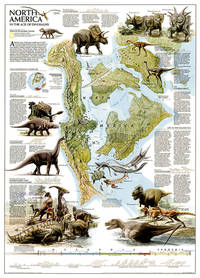
National Geographic Maps
National Geographic Dinosaurs of North America Wall Map 22.25 x 30.5 in National Geographic Reference Map
National Geographic 2010-01-01. 2010. map. New. 3.00x3.00x27.00. Buy with confidence. Excellent Customer Service & Return policy. National Geographic unknown
书商的参考编号 : DADAX0792249763 ???????? : 0792249763 9780792249764
|
|
|
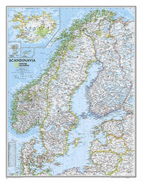
National Geographic Maps
National Geographic Scandinavia Wall Map - Classic 23.5 x 30.25 in National Geographic Reference Map
Natl Geographic Society Maps 2019-09-01. 2019. map. New. 3.00x3.00x27.00. Buy with confidence. Excellent Customer Service & Return policy. Natl Geographic Society Maps unknown
书商的参考编号 : DADAX0792249852 ???????? : 0792249852 9780792249856
|
|
|
National Geographic Maps
National Geographic California Wall Map - Laminated 33.5 X 40.5 In
National Geographic Maps 2023. Unbound. Good. Missing dust jacket; Pages can have notes/highlighting. Spine may show signs of wear. ~ ThriftBooks: Read More Spend Less.Dust jacket quality is not guaranteed. National Geographic Maps unknown
书商的参考编号 : G1597752061I3N01 ???????? : 1597752061 9781597752060
|
|
|
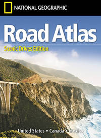
National Geographic Maps
National Geographic Road Atlas 2026: Scenic Drives Edition United States Canada Mexico
National Geographic Maps 2025-06-01. 2026. paperback. Good. 9.5X6.5X1.5. Buy with confidence. Excellent Customer Service & Return policy. National Geographic Maps paperback
书商的参考编号 : ANAIS-1566957060 ???????? : 1566957060 9781566957069
|
|
|
National Geographic Maps
National Geographic Road Atlas 2026: Adventure Edition United States Canada Mexico
National Geographic Maps 2025-07-11. 2026. spiral-bound. Good. 9.5X6.5X1.5. Buy with confidence. Excellent Customer Service & Return policy. National Geographic Maps unknown
书商的参考编号 : ANAIS-0792289897 ???????? : 0792289897 9780792289890
|
|
|
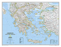
National Geographic Maps
National Geographic Greece Wall Map - Classic 30.25 x 23.5 in National Geographic Reference Map
Natl Geographic Society Maps. New. Special order direct from the distributor Natl Geographic Society Maps unknown
书商的参考编号 : ING9780792249696 ???????? : 0792249690 9780792249696
|
|
|
National Geographic Maps
National Geographic Greece Wall Map - Classic 30.25 x 23.5 in National Geographic Reference Map
National Geographic 2022-01-19. 2022. map. Used: Good. 3.00x3.00x27.00. Buy with confidence. Excellent Customer Service & Return policy. National Geographic unknown
书商的参考编号 : SONG0792249690 ???????? : 0792249690 9780792249696
|
|
|
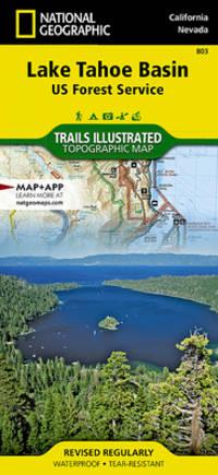
National Geographic Maps
National Geographic Trails Illustrated Map Lake Tahoe Basin USDA Forest Service
Trails are classified by use - hiking horse and hike mountain bike shared use or motorized - and includes a trail chart showing trail name location and allowed use. Trail mileage private land designation and information on general regulations safety Desolation Wilderness camping fishing and snow parks round out the usefulness of this map. It also includes bathymetric shading of the Lake Tahoe. Coverage includes Lake Tahoe Basin Management Unit Eldorado Humboldt-Toiyabe and Tahoe national forests. Desolation Granite Chief and Mt. Rose Wilderness Areas. Pacific Crest National Scenic Trail. Tahoe Rim Trail. Rubicon OHV Trail. Emerald Bay D.L. Bliss Ed Z'Berg Sugar Pine Burton Creek Donner Memorial Lake Tahoe Nevada and Washoe Lake state parks. Mt. Tallac Echo Summit Carson Pass Spooner Summit Mt. Rose Summit Brockway Summit. Towns: Truckee Tahoe City Homewood Tahoma South Lake Tahoe Zephyr Cove Incline Village Kings Beach Carson City. Includes UTM grids for use with your GPS unit and a trail mileage matrix. unknown
书商的参考编号 : BIBUP61025-A31493 ???????? : 1566953340 9781566953344
|
|
|
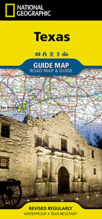
National Geographic Maps
National Geographic Texas 2017 Map
- Waterproof - Tear-Resistant - Travel Map Expertly researched and loaded with helpful information National Geographic's Texas Guide Map is a must-have for travelers exploring ""The Lone Star State."" In addition to a state map inset maps provide detail on the Texas Panhandle and the cities of Dallas Fort Worth Houston Amarillo Abilene Lubbock Waco Laredo Beaumont El Paso Odessa-Midland McAllen Corpus Christi San Antonio and Austin. Cities and towns are easy to find with the map's helpful index and hundreds of attractions are noted. Road network designations are clear and distances in miles on major highways are shown. Additional information and maps feature the recreation activities available in Big Bend National Park and the attractions along the Hill Country scenic drive. The Alamo the Space Center Houston the San Antonio Riverwalk and Guadalupe Mountains National Park are just some of the many points of interest that are highlighted. A handy chart of park service sites and climate information are also included. Every State Guide Map is printed on durable synthetic paper making them waterproof tear-resistant and tough -- capable of withstanding the rigors of any kind of travel. Map Scale = 1:31680000 Sheet Size = 24.75"" x 17.75"" Folded Size = 4"" x 8.75"" unknown
书商的参考编号 : BIBUP61025-A19915 ???????? : 156695729X 9781566957298
|
|
|
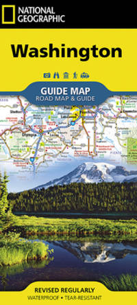
National Geographic Maps
National Geographic Washington
unknown
书商的参考编号 : BIBUP61025-A20047 ???????? : 1566957796 9781566957793
|
|
|
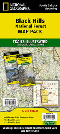
National Geographic Maps; National Geographic Maps - Trails Illustrated
National Geographic Black Hills National Forest Map Pack Bundle
Waterproof Tear-Resistant Travel MapThe Black Hills National Forest Map Pack Bundle is the perfect companion for anyone planning a trip to the Black Hills of South Dakota. The two maps in this Map Pack Bundle cover the Black Hills National Forest in great detail and include all of the information needed for a memorable trip for the first time or the frequent visitor. The maps include trails with mileage between intersections numbered US Forest Service roads motorized trails as well as hundreds of points of interest such as campgrounds trail heads and boat ramps. ""Buy the Map Pack and save 15%!"" The Black Hills National Forest Map Pack includes: Map 238:: Black Hills South Black Hills National ForestMap 751:: Black Hills North Black Hills National ForestEvery Trails Illustrated map is printed on ""Backcountry Tough"" waterproof tear-resistant paper. A full UTM grid is printed on the map to aid with GPS navigation.""Map Scale = 1:70000Sheet Size = 37.75"" x 25.5""Folded Size = 4.25"" x 9.25"""""" unknown
书商的参考编号 : BIBUP61025-A51244 ???????? : 159775398X 9781597753982
|
|
|
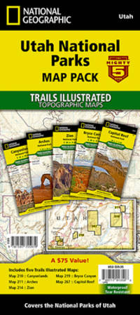
National Geographic Society Maps; National Geographic Maps - Trails Illustrated
National Geographic Utah National Parks Map Pack Bundle
Waterproof Tear-Resistant Topographic Map The five iconic national parks in the high desert of Utah are all provided in this single easy to purchase product. You get the maps for the best road trip of your life all while saving over 15%. Like all Trails Illustrated maps the Utah National Parks Bundle set is frequently revised and printed on waterproof tear-resistant material to stand up to all conditions. This detailed topographic recreation map bundle contains carefully researched trails campsites forest service roads and points-of-interests. Includes UTM grids for use with your GPS unit. Coverage includes the The Mighty 5 national parks of Utah: Arches Bryce Canyon Canyonlands Capitol Reef and Zion National Parks.""Map Scale = 1:35000 & 1:75000Sheet Size = 37.75"" x 25.5""Folded Size = 4.25"" x 9.25"""""" unknown
书商的参考编号 : BIBUP61025-A55528 ???????? : 1597755974 9781597755979
|
|
|
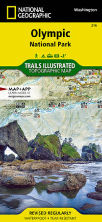
National Geographic Maps (Firm)
National Geographic Trails Illustrated Map Olympic National Park
• Waterproof • Tear-Resistant • Topographic Map Within the park there is detailed coverage of Mount Olympus Tshletshy Ridge Hurrican Ridge Huelsdonk Ridge Bailey Range camping areas facilities ranger stations nature trails waterfalls boat launches and much more. Also included are the Mount Skokomish Wilderness Ozette Lake Lake Pleasant Lake Crescent Lake Mills and Olympic National Forest. The map is full of detailed trail information points of interest trailheads picnic areas facitlities and more. Includes UTM grids for use with your GPS unit. Sheet Size = 25.50 x 37.75 Folded Size = 4.25 x 9.25 Scale = 1:100000 unknown
书商的参考编号 : BIBUP61025-A23283 ???????? : 1566954029 9781566954020
|
|
|
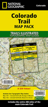
National Geographic Maps - Trails Illustrated
National Geographic Trails Illustrated Colorado Trail Map Pack
- Waterproof - Tear-Resistant - Topographic Maps In a state known for its trails The Colorado Trail is Colorado's premier long distance trail. Conceived in 1973 and completed in 1987 the trail runs 486 miles between Denver and Durango traversing some of the most spectacular scenery in the state. This Map Pack combines the entire standard route into a single easy to purchase product. Buy the Map Pack and save 15%! The Colorado Trail Map Pack includes: Map 1201:: Colorado Trail South Map 1202:: Colorado Trail North More convenient and easier to use than folded maps but just as compact and lightweight National Geographic's Topographic Map Guide booklets are printed on 'Backcountry Tough' waterproof tear-resistant paper with stainless steel staples. A full UTM grid is printed on the map to aid with GPS navigation. Map Scale = 1:75000 Folded Size = 4.25 x 9.38 unknown
书商的参考编号 : BIBUP61025-A51245 ???????? : 1566957400 9781566957403
|
|
|
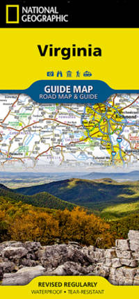
National Geographic Maps
National Geographic Virginia GuideMap
The front side is an easy-to-read road map with insets of: - Washington DC area - Charlottesville - Lynchburg - Roanoke - Southwest Virginia - Colonial National Historical Park The back includes: - Maps and information for Richmond and Hampton Roads - Information for Shenandoah National Park - Points of interest - Scenic drive - Park Service sites in Virginia unknown
书商的参考编号 : BIBUP61025-A20048 ???????? : 1597750603 9781597750608
|
|
|
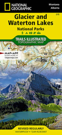
National Geographic Maps
National Geographic Trails Illustrated Map Glacier / Waterton Lakes National Parks
• Waterproof • Tear-Resistant • Topographic Map Waterton Lakes National Park includes Waterton Park Upper and Middle Waterton Lakes The Border Ranges Akamina Kishinena Provincial Park Blood Timber Reserve and more. Glacier National Park includes the entire national park area with detailed trails and topographic information. Includes the Lewis and Clark Range Many Glacier Lake McDonald Great Bear Wilderness Flathead National Forest Columbia Falls Horse Reservoir St. Mary Lake and much more. Includes UTM grids for use with your GPS unit. Sheet Size = 37.75 x 25.50 Folded Size = 4.25 x 9.25 Scale = 1:100000 unknown
书商的参考编号 : BIBUP61025-A34306 ???????? : 1566953189 9781566953184
|
|
|
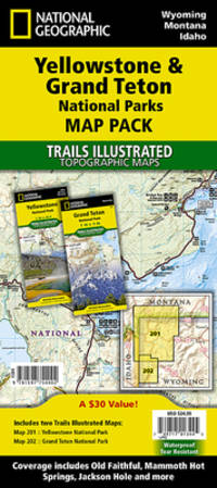
National Geographic Maps; National Geographic Maps - Trails Illustrated
National Geographic Yellowstone and Grand Teton National Parks Map Pack Bundle
• Waterproof • Tear-Resistant • Topographic Map Seeking the best combination of detailed maps and value for your trip to the Yellowstone and Grand Teton area then get our bundle pack. It includes both Yellowstone and Grand Teton National Park Trails Illustrated Maps providing you coverage of the entire region while saving you over 15%. Like all Trails Illustrated maps the Yellowstone Grand Teton Bundle set is frequently revised and printed on waterproof tear-resistant material to stand up to all conditions. Includes UTM grids for use with your GPS unit. Sheet Size = 37.75 x 25.00 Folded Size = 4.25 x 9.25 Scale = 1:126720 & 1:80000 unknown
书商的参考编号 : BIBUP61025-A47423 ???????? : 1597754005 9781597754002
|
|
|
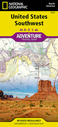
National Geographic Maps - Adventure
National Geographic United States Southwest
- Waterproof - Tear-Resistant - Travel Map There are few nations as vast and spectacularly diverse as the United States of America. From the Atlantic to the Pacific ""America the Beautiful"" offers boundless destinations and experiences for travelers seeking outdoor adventures small town delights or the excitement of urban culture. The United States Southwest Adventure Map will guide you through one of the most iconic and awe-inspiring regions on Earth. The states of Arizona and New Mexico contain Grand Canyon Petrified Forest and Saguaro National Parks Monument Valley Sonoran Desert and dozens of celebrated National Monuments Forests and Wilderness Areas. The map includes the cities of Phoenix Tucson Sedona Flagstaff Santa Fe and Albuquerque as well as the Navajo Apache Hopi and many other Indian Reservations. It covers the entire Four Corners Region including the southern halves of Utah and Colorado. There is simply no better map for exploring the Southwestern United States. National Geographic's US Adventure Maps provide the most authoritative and convenient travel maps available to plan and guide your USA Adventure. Each map delivers the perfect combination of detail and perspective highlighting travel routes topography and points of interest for those venturing beyond the city centers. Whether you're on a classic American road trip or planning a grand tour to visit several cities or national parks these maps offer the ultimate geographic resource as only National Geographic can provide. Every Adventure Map is printed on durable synthetic paper making them waterproof tear-resistant and tough -- capable of withstanding the rigors of international travel. Map Scale = 1:1300000 Sheet Size = 25.5"" x 37.75"" Folded Size = 4.25"" x 9.25"" unknown
书商的参考编号 : BIBUP61025-A31567 ???????? : 156695715X 9781566957151
|
|
|
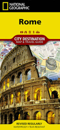
National Geographic Maps
National Geographic Destination City Map 2018 Rome
- Waterproof - Tear-Resistant - Travel Map One of the most visited places in the world for the past two millennia Rome has been an important city for Western Civilization as well for Christianity. Let National Geographic's City Destination map of Rome lead you on your exploration of this fascinating ancient destination. Combining an easy-to-read road map along with a travel guide this expertly researched map is unparalleled in its accuracy and content making it the ideal travel companion as well as the perfect complement to National Geographic's Rome Traveler Guide. The front side has a regional map and descriptions of the city many popular attractions and the transit system. A user-friendly index of streets hotels and points of interest along with a metro or Metropolitana map and a diagram of Fiumicino Airport will help you arrive at your destination quickly. An inset map of Vatican City provides details of this very popular area. The road map on the reverse side labels main secondary and one-way streets with a multi-language legend. In addition hundreds are popular and lesser known points of interest are pinpointed including metro stations places of worship theaters hotels hospitals police stations and notable buildings. Every Destination Map is printed on durable synthetic paper making them waterproof tear-resistant and tough -- capable of withstanding the rigors of any kind of travel. Map Scale = 1:9600 Sheet Size = 24.75"" x 17.75"" Folded Size = 4"" x 8.75"" unknown
书商的参考编号 : BIBUP61025-A20039 ???????? : 1566957702 9781566957700
|
|
|
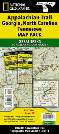
National Geographic Maps
National Geographic Trails Illustrated Map 2020 Appalachian Trail
- Waterproof - Tear-Resistant - Topographic Maps The Appalachian Trail AT Map Pack Bundle of Georgia North Carolina and Tennessee includes two Topographic Map Guides that cover the AT from the southern terminus at Springer Mountain to Damasus on the Tennessee-Virginia state line. The southernmost section of the AT offers some of most physically challenging but rewarding hiking along the entire trail including a more than 70 mile long section that passes through Great Smoky Mountains National Park. Each AT Topographic Map Guide includes detailed topographic maps at a scale of 1 inch = 1 mile. Each page is centered on the A.T. and overlaps with the adjacent pages so there is little chance of getting lost. Along the bottom of each page is a trail profile that shows the distance between shelters camping areas and trail access points. The map and trail profile provide a step by step visual guide to hiking the trail mile by rugged mile. The Topographic Map Guide is built for all levels of hiking enthusiasts from the day tripper to the multi month 'thru-hiker'. The front pages of the printed Topographic Map Guide include resupply information town inset maps camping options and much more. Buy the Map Pack and save over 15%! The Appalachian Trail: Georgia North Carolina Tennessee Map Pack Bundle includes: Map 1501:: Springer Mountain to Davenport Gap Georgia North Carolina Tennessee Map 1502:: Davenport Gap to Damascus North Carolina Tennessee More convenient and easier to use than folded maps but just as compact and lightweight National Geographic's Topographic Map Guide booklets are printed on 'Backcountry Tough' waterproof tear-resistant paper with stainless steel staples. A full UTM grid is printed on the map to aid with GPS navigation. Map Scale = 1:63360 Folded Size = 4.25 x 9.38 unknown
书商的参考编号 : BIBUP61025-A51243 ???????? : 1566958377 9781566958370
|
|
|
National Geographic Maps
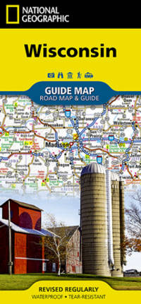
National Geographic Wisconsin 2017 Map
- Waterproof - Tear-Resistant - Travel Map National Geographic's Wisconsin Guide Map provides travelers with the perfect combination of detail and perspective in a highly functional travel tool. Cities and towns are clearly indicated and easy to find in the user-friendly index. A complete road network of highways tollways and other roads along with distances noted in miles for major highways will help you find the route that's right for you. National and state parks public campsites visitor information centers airports ski areas hospitals and more are noted as well. A chart of park service sites and climate information will be particularly helpful to travelers taking in the many outdoor activities in Wisconsin. Inset maps of the cities of Madison Milwaukee Superior Appleton Oshkosh Racine-Kenosha Milwaukee Green Bay and Eau Claire provide greater detail of these urban centers. A handy combination of map and guidebook this map is also loaded with information on varied points of interest including St. Croix National Scenic Riverway Apostle Islands National Lakeshore and Great River Road a scenic byway along Route 35 between La Crosse and Prairie du Chien. Every State Guide Map is printed on durable synthetic paper making them waterproof tear-resistant and tough -- capable of withstanding the rigors of any kind of travel. Map Scale = 1:1267000 Sheet Size = 17.75"" x 24.75"" Folded Size = 4"" x 8.75"" unknown
书商的参考编号 : BIBUP61025-A46675 ???????? : 156695732X 9781566957328
|
|
|
National Geographic Maps; National Geographic Maps - Trails Illustrated
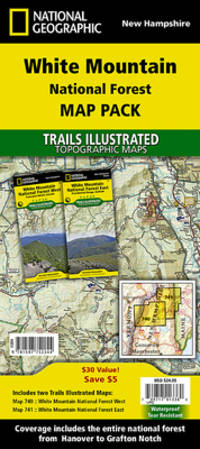
National Geographic White Mountain National Forest Map Pack Bundle Map
• Waterproof • Tear-Resistant • Topographic Map Seeking the best combination of detailed maps and value for your trip to New Hampshire's White Mountains then get our bundle pack. It includes both Presidential Range and Franconia Notch/Lincoln Trails Illustrated Maps providing you coverage of the entire region while saving you over 15%. Like all Trails Illustrated maps the White Mountain Bundle set is frequently revised and printed on waterproof tear-resistant material to stand up to all conditions. Includes UTM grids for use with your GPS unit. unknown
书商的参考编号 : BIBUP61025-A52503 ???????? : 159775224X 9781597752244
|
|
|
National Geographic Maps
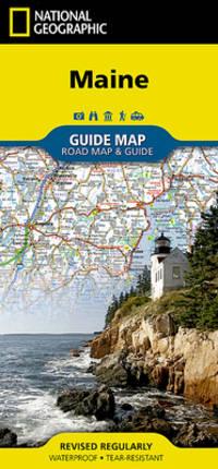
National Geographic Guide Map Maine
• Waterproof • Tear-Resistant • Travel Map The front side is an easy-to-read road map with insets of: - Portland - Bangor - Lewiston / Auburn - Augusta The back includes: - Maps and information for Portland Freeport/Yarmouth and Bar Harbor - Information for Acadia National Park - Points of interest - Scenic drive - Park Service sites in Maine Fold Size = 4.00 x 8.75 Sheet Size = 17.75 x 24.75 Scale = unknown
书商的参考编号 : BIBUP61025-A20050 ???????? : 1597753149 9781597753142
|
|
|
National Geographic Maps
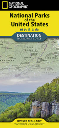
National Geographic Destination Map 2018 National Parks of the United States
- Waterproof - Tear-Resistant - Travel Map National Geographic's Destination Map of National Parks of the United States highlights the nearly 400 magnificent parks across America. The country is represented in subtle earth-tones with shaded mountain relief and intricately drawn river systems. Photos capture some of the diverse landscapes preserved and protected by the national park system. A list of all park service units sorted by state is also included to help you find the closest park national monument or national historic site. Every Destination Map is printed on durable synthetic paper making them waterproof tear-resistant and tough -- capable of withstanding the rigors of any kind of travel. Map Scale = 1:5200000 Sheet Size = 37.75"" x 25.5"" Folded Size = 4.25"" x 9.25"" unknown
书商的参考编号 : BIBUP61025-A31492 ???????? : 1566957516 9781566957519
|
|
|
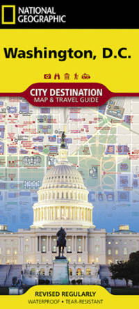
National Geographic Maps
National Geographic City Destination Washington D.C.
unknown
书商的参考编号 : BIBUP61025-A20963 ???????? : 1566957303 9781566957304
|
|
|
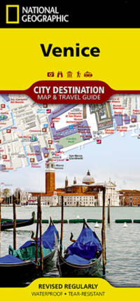
National Geographic Maps
National Geographic City Destination Map Venice
- Waterproof - Tear-Resistant - Travel Map Home to the gondola and Grand Canal Venice a popular tourist destination and international luxury destination. Covering this beautiful city's road and waterways with unparalleled detail National Geographic's City Destination map of Venice combines an easy-to-read street map with a travel guide. Displayed throughout the map are hundreds of points of interest including gondola stands water bus stations theaters hotels churches parks notable buildings. Many of the city's top attractions are depicted in 3D including Basilica di San Marco Galleria dell'Accademia and Santa Maria Gloriosa dei Frari. Inset maps cover the areas of Lido and Murano while a regional map shows the city's location in the heart of the Venetian Lagoon. A user friendly index of streets land and water features hotels and points of interest will help you find your destination and plan your route quickly. A comprehensive vaperetto water bus map and diagram of Marco Polo Airport will aid in your navigation into and around the city. Background information about the city its most popular attractions and transit system is also provided. Every Destination Map is printed on durable synthetic paper making them waterproof tear-resistant and tough -- capable of withstanding the rigors of any kind of travel. Map Scale = 1:6500 Sheet Size = 24.75"" x 17.75"" Folded Size = 4"" x 8.75"" unknown
书商的参考编号 : BIBUP61025-A47203 ???????? : 1566957281 9781566957281
|
|
|
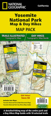
National Geographic Maps
National Geographic Trails Illustrated Map 2020 Yosemite National Park Map & Day Hikes Map Pack Bundle
- Waterproof - Tear-Resistant - Topographic Maps Yosemite National Park has some of the most stunning landscapes in the world. This two title Map Pack Bundle helps explorers of all levels see everything this astounding park has to offer. The map pack includes an overview map that shows the entire park as well as a Day Hikes map guide. With this combination of maps visitors can feel comfortable planning a trip to a park with options for everyone from multi-day backpack trips to short hikes in Yosemite Valley. The Yosemite National Park Day Hikes Topographic Map Guide includes eighteen diverse hikes for all hiking enthusiasts from the easy 2.8 mile long Hetch Hetchy Valley Overlook to the strenuous 14.7 mile long Laurel Lake Trail with 3900' of elevation gain. Each hike has a detailed map a trail profile visualizing the changes in elevation and a short summary of the interesting features encountered along the trip. Buy the Map Pack and save 15%! The Yosemite National Park and Day Hikes Map Pack includes: Map 206:: Yosemite National Park Map 1704:: Yosemite National Park Day Hikes Every Trails Illustrated map is printed on 'Backcountry Tough' waterproof tear-resistant paper. National Geographic's Topographic Map Guide booklets are printed on 'Backcountry Tough' waterproof tear-resistant paper with stainless steel staples. A full UTM grid is printed on the map to aid with GPS navigation. Map Scale = 1:80000 Sheet Size = 25.5 x 37.75 Folded Size = 4.25 x 9.25 unknown
书商的参考编号 : BIBUP61025-A47550 ???????? : 1566958369 9781566958363
|
|
|
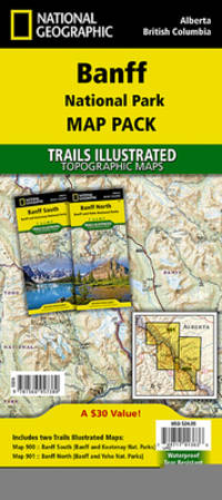
National Geographic Maps - Trails Illustrated
National Geographic Trails Illustrated Jasper National Park Map Pack
- Waterproof - Tear-Resistant - Topographic Maps Banff is Canada's first and most visited national park. Banff is one of the world's premiere destinations spanning a region of unparalleled majestic mountain scenery. This Map Pack combines two maps that cover Banff Yoho and Kootenay National Parks. All three national parks cover one of the most rugged areas in North America with mountain glaciers and breathtaking lakes. Buy the Map Pack and save 15%! The Banff National Park Map Pack includes: Map 901:: Banff North Banff and Yoho National Parks Map 900:: Banff South Banff and Kootenay National Parks Every Trails Illustrated map is printed on ""Backcountry Tough"" waterproof tear-resistant paper. A full UTM grid is printed on the map to aid with GPS navigation. Map Scale = 1:100000 Sheet Size = 37.75"" x 25.5"" Folded Size = 4.25"" x 9.25"" unknown
书商的参考编号 : BIBUP61025-A51239 ???????? : 1566957389 9781566957380
|
|
 ?????????
 ?????PDF???
 RSS feed


