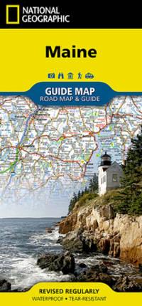
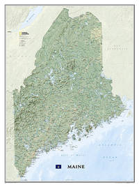
• Waterproof • Tear-Resistant • Travel Map The front side is an easy-to-read road map with insets of: - Portland - Bangor - Lewiston / Auburn - Augusta The back includes: - Maps and information for Portland Freeport/Yarmouth and Bar Harbor - Information for Acadia National Park - Points of interest - Scenic drive - Park Service sites in Maine Fold Size = 4.00 x 8.75 Sheet Size = 17.75 x 24.75 Scale = unknown
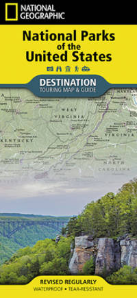
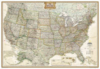
- Waterproof - Tear-Resistant - Travel Map National Geographic's Destination Map of National Parks of the United States highlights the nearly 400 magnificent parks across America. The country is represented in subtle earth-tones with shaded mountain relief and intricately drawn river systems. Photos capture some of the diverse landscapes preserved and protected by the national park system. A list of all park service units sorted by state is also included to help you find the closest park national monument or national historic site. Every Destination Map is printed on durable synthetic paper making them waterproof tear-resistant and tough -- capable of withstanding the rigors of any kind of travel. Map Scale = 1:5200000 Sheet Size = 37.75"" x 25.5"" Folded Size = 4.25"" x 9.25"" unknown
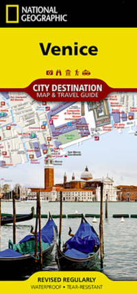
- Waterproof - Tear-Resistant - Travel Map Home to the gondola and Grand Canal Venice a popular tourist destination and international luxury destination. Covering this beautiful city's road and waterways with unparalleled detail National Geographic's City Destination map of Venice combines an easy-to-read street map with a travel guide. Displayed throughout the map are hundreds of points of interest including gondola stands water bus stations theaters hotels churches parks notable buildings. Many of the city's top attractions are depicted in 3D including Basilica di San Marco Galleria dell'Accademia and Santa Maria Gloriosa dei Frari. Inset maps cover the areas of Lido and Murano while a regional map shows the city's location in the heart of the Venetian Lagoon. A user friendly index of streets land and water features hotels and points of interest will help you find your destination and plan your route quickly. A comprehensive vaperetto water bus map and diagram of Marco Polo Airport will aid in your navigation into and around the city. Background information about the city its most popular attractions and transit system is also provided. Every Destination Map is printed on durable synthetic paper making them waterproof tear-resistant and tough -- capable of withstanding the rigors of any kind of travel. Map Scale = 1:6500 Sheet Size = 24.75"" x 17.75"" Folded Size = 4"" x 8.75"" unknown
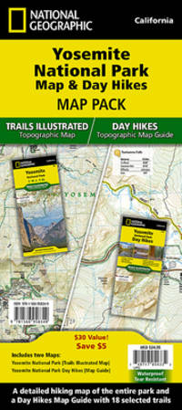
- Waterproof - Tear-Resistant - Topographic Maps Yosemite National Park has some of the most stunning landscapes in the world. This two title Map Pack Bundle helps explorers of all levels see everything this astounding park has to offer. The map pack includes an overview map that shows the entire park as well as a Day Hikes map guide. With this combination of maps visitors can feel comfortable planning a trip to a park with options for everyone from multi-day backpack trips to short hikes in Yosemite Valley. The Yosemite National Park Day Hikes Topographic Map Guide includes eighteen diverse hikes for all hiking enthusiasts from the easy 2.8 mile long Hetch Hetchy Valley Overlook to the strenuous 14.7 mile long Laurel Lake Trail with 3900' of elevation gain. Each hike has a detailed map a trail profile visualizing the changes in elevation and a short summary of the interesting features encountered along the trip. Buy the Map Pack and save 15%! The Yosemite National Park and Day Hikes Map Pack includes: Map 206:: Yosemite National Park Map 1704:: Yosemite National Park Day Hikes Every Trails Illustrated map is printed on 'Backcountry Tough' waterproof tear-resistant paper. National Geographic's Topographic Map Guide booklets are printed on 'Backcountry Tough' waterproof tear-resistant paper with stainless steel staples. A full UTM grid is printed on the map to aid with GPS navigation. Map Scale = 1:80000 Sheet Size = 25.5 x 37.75 Folded Size = 4.25 x 9.25 unknown
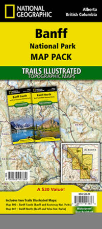
- Waterproof - Tear-Resistant - Topographic Maps Banff is Canada's first and most visited national park. Banff is one of the world's premiere destinations spanning a region of unparalleled majestic mountain scenery. This Map Pack combines two maps that cover Banff Yoho and Kootenay National Parks. All three national parks cover one of the most rugged areas in North America with mountain glaciers and breathtaking lakes. Buy the Map Pack and save 15%! The Banff National Park Map Pack includes: Map 901:: Banff North Banff and Yoho National Parks Map 900:: Banff South Banff and Kootenay National Parks Every Trails Illustrated map is printed on ""Backcountry Tough"" waterproof tear-resistant paper. A full UTM grid is printed on the map to aid with GPS navigation. Map Scale = 1:100000 Sheet Size = 37.75"" x 25.5"" Folded Size = 4.25"" x 9.25"" unknown
 ?????????
 ?????PDF???
 RSS feed