|
[IGN]
CARTE IGN n° 176 : AJACCIO, BONIFACIO
Une carte topographique série "Top 100 - Tourisme et Découverte" au 1:100.000e, éditée en 2010, bon état
书商的参考编号 : LFA-126745997
|
|
|
[IGN]
CARTE IGN n° 1824 : SAINTE-MAURE-de-TOURAINE
Une carte topographique série orange au 1:50.000e, éditée en 1980, bon état
书商的参考编号 : LFA-126744319
|
|
|
[IGN]
CARTE IGN n° 1921 OUEST : VILLEDÔMER, AUTHON
Une carte topographique série bleue au 1:25.000e, éditée en 2005, bon état
书商的参考编号 : LFA-126744311
|
|
|
[IGN]
CARTE IGN n° 1943 : GIMONT
Une carte topographique série orange au 1:50.000e, éditée en 1981, bon état
书商的参考编号 : LFA-126744318
|
|
|
[IGN]
CARTE IGN n° 2048 : AULUS-les-BAINS
Une carte topographique série orange au 1:50.000e, éditée en 1987, bon état
书商的参考编号 : LFA-126744314
|
|
|
[IGN]
CARTE IGN n° 2142 : VILLEMUR-sur-TARN
Une carte topographique série orange au 1:50.000e, éditée en 1982, bon état
书商的参考编号 : LFA-126744317
|
|
|
[IGN]
CARTE IGN n° 2144 : VILLEFRANCHE-de-LAURAGAIS
Une carte topographique série orange au 1:50.000e, éditée en 1982, bon état
书商的参考编号 : LFA-126744316
|
|
|
[IGN]
CARTE IGN n° 2145 : SAVERDUN
Une carte topographique série orange au 1:50.000e, éditée en 1983, bon état
书商的参考编号 : LFA-126744315
|
|
|
[IGN]
CARTE IGN n° 2245 : CASTELNAUDARY
Une carte topographique série orange au 1:50.000e, éditée en 1982, bon état
书商的参考编号 : LFA-126744313
|
|
|
[IGN]
CARTE IGN n° 2726 OUEST : BOURBON-LANCY
Une carte topographique série bleue au 1:25.000e, éditée en 2010, bon état
书商的参考编号 : LFA-126744310
|
|
|
[IGN]
CARTE IGN n° 2829 EST : BEAUJEU
Une carte série bleue au 1:25.000e, éditée en 1984, bon état
书商的参考编号 : LFA-126740298
|
|
|
[IGN]
CARTE IGN n° 2829 EST : CHARLIEU
Une carte série bleue au 1:25.000e, éditée en 1982, bon état
书商的参考编号 : LFA-126740295
|
|
|
[IGN]
CARTE IGN n° 2830 EST : le BOIS d'OINGT
Une carte série bleue au 1:25.000e, éditée en 1996, bon état
书商的参考编号 : LFA-126740296
|
|
|
[IGN]
CARTE IGN n° 2830 EST : le BOIS d'OINGT
Une carte série bleue au 1:25.000e, éditée en 1984, bon état
书商的参考编号 : LFA-126740297
|
|
|
[IGN]
CARTE IGN n° 2830 OUEST : AMPLEPUIS
Une carte série bleue au 1:25.000e, éditée en 1984, bon état
书商的参考编号 : LFA-126740299
|
|
|
[IGN]
CARTE IGN n° 2931 EST : L'ARBRESLE
Une carte série bleue au 1:25.000e, éditée en 1991, bon état
书商的参考编号 : LFA-126740294
|
|
|
[IGN]
CARTE IGN n° 2933 EST : MASSIF du PILAT, SAINT-ETIENNE, SAINT-CHAMOND, Parc Naturel Régional du Pilat
Une carte topographique série bleue au 1:25.000e, éditée en 2008, bon état
书商的参考编号 : LFA-126744309
|
|
|
[IGN]
CARTE IGN n° 3028 : MACON
Une carte topographique série orange au 1:50.000e, éditée en 1984, bon état
书商的参考编号 : LFA-126740292
|
|
|
[IGN]
CARTE IGN n° 3031 OUEST : LYON
Une carte série bleue au 1:25.000e, éditée en 1988, bon état
书商的参考编号 : LFA-126740293
|
|
|
[IGN]
CARTE IGN n° 3335 EST : VIZILLE EST
Une carte topographique série bleue au 1:25.000e, éditée en 1978, bon état
书商的参考编号 : LFA-126743132
|
|
|
[IGN]
CARTE IGN n° 3433 EST : SAINT JEAN de MAURIENNE, SAINT FRANCOIS LONGCHAMP, VALMOREL
Une carte topographique série bleue au 1:25.000e, éditée en 1990, bon état
书商的参考编号 : LFA-126743133
|
|
|
[IGN]
CARTE IGN n° 3437 EST : ORCIERES-MERLETTE, SIRAC MOURRE FROID, Parc National des Ecrins
Une carte topographique série bleue au 1:25.000e, éditée en 2005, bon état
书商的参考编号 : LFA-126744312
|
|
|
[IGN]
CARTE IGN n° 3530 EST : SAMOENS, HAUT-GIFFRE
Une carte topographique série bleue au 1:25.000e, éditée en 1996, bon état
书商的参考编号 : LFA-126744307
|
|
|
[IGN]
CARTE IGN n° 3634 OUEST : VAL CENIS, CHARBONNEL
Une carte topographique série bleue au 1:25.000e, éditée en 1996, bon état
书商的参考编号 : LFA-126744308
|
|
|
[IGN]
CARTE IGN n° 43 : LYON - VICHY
Une carte série verte au 1:100.000e, éditée en 1985, bon état
书商的参考编号 : LFA-126740290
|
|
|
[IGN]
CARTE IGN n° 48 : PERIGUEUX TULLE
Une carte série verte au 1:100.000e, éditée en 1985, bon état
书商的参考编号 : LFA-126728940
|
|
|
[IGN]
CARTE IGN n° 50 : SAINT-ETIENNE - LE PUY
Une carte série verte au 1:100.000e, éditée en 1987, bon état
书商的参考编号 : LFA-126740291
|
|
|
[IGN]
CARTE IGN n° 50 : SAINT-ETIENNE - LE PUY-en-VELAY
Une carte série verte au 1:100.000e, éditée en 1999, IGN, bon état
书商的参考编号 : LFA-126750291
|
|
|
[IGN]
CARTE IGN n° 51 : LYON GRENOBLE
Une carte topographique TOP 100 au 1:100.000e, éditée en 2003, bon état
书商的参考编号 : LFA-126744320
|
|
|
[IGN]
CARTE IGN n° D12: AVEYRON
Une carte départementale routière et administrative au 1:200.000e, éditée en 2010, bon état
书商的参考编号 : LFA-126728943
|
|
|
[IGN]
CARTE IGN n° D42 : LOIRE
Une carte départementale routière et administrative au 1:150.000e, éditée en 2014, bon état
书商的参考编号 : LFA-126749976
|
|
|
[IGN]
CARTE IGN RHONE-ALPES
Une carte routière et touristique R14 au 1:250.000e, éditée en 2014, bon état
书商的参考编号 : LFA-126749433
|
|
|
[IGN]
CARTE IGN RHONE-ALPES
Une carte routière et touristique R14 au 1:250.000e, éditée en 2009, Michelin, bon état
书商的参考编号 : LFA-126750290
|
|
|
[ILE DE LA REUNION] [CARTES POSTALES ANCIENNES]
Cartes postales anciennes sur l'Ile de la Réunion
Paris, Messageries Matimes, début du 20e siècle 1 ensemble de 10 cartes postales anciennes sur l'Ile de La Réunion
书商的参考编号 : 13420
|
|
|
[ILE MAURICE] [CARTES POSTALES ANCIENNES]
Cartes postales anciennes sur l'Ile Maurice
Paris, Messageries Matimes, début du 20e siècle 1 ensemble de 4 cartes postales anciennes sur l'Ile Maurice
书商的参考编号 : 13422
|
|
|
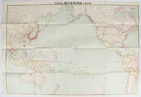
[INAGAKI, RIKICHI]. 稲垣利吉.
日・米・英・勢力圖太平洋上: 比較對照. Nichi bei ei seiryokuzu Taiheiyojo : Hikaku taisho. Military Strength of Japan the United States and the United Kingdom on the Pacific: A Comparison Map.
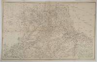
東京. Tokyo.: 九段書房.Kudan shobo. 大正十四 1925. Coloured folding Japanese map showing the military strength of Japan the United States and the United Kingdom in the Pacific original pictorial envelope scale not given. Some small holes at folds occasional light foxing a prior owner's signature on reverse minor wear envelope. Very good copy in like envelope. Map measures 54.4 x 78.8cm. The explanatory text in Japanese printed on the reverse in blue summarises the colonial possessions of the US and the UK as well as providing a comparison between the land size naval presence natural resources immigration issues and maritime transport capacities of Japan the United States and the United Kingdom. Legend indicates national regional provincial territorial boundaries canals undersea cables airline routes metropolitans capital cities mining fields hot springs ancient battle fields major trade ports Japanese embassies and consular offices. A large area marked 日本委任统治 "South Pacific Mandate" highlighted in a box is adjacent to Australian occupied Papua New Guinea. . 九段書房.[Kudan shobo]. unknown
书商的参考编号 : 169329
|
|
|
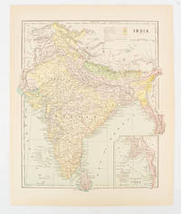
[INDIA - MAP.] FISK & CO. (ENGRAVERS)
India
New York. circa1910. Printed colour map 29 x 25 cm with inset map of the Eastern Part of India colour key reference key to the ruling divisions current and projected railways and telegraphs also shown central fold slight toning; in very good condition. Interesting map shaded by Divisions: the Presidencies of Bengal Madras Bombay Ceylon "Native States under British Protection" and "Independent States" Nepal and Bhutan. . unknown
书商的参考编号 : 174839
|
|
|
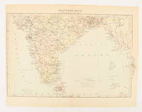
[INDIA - MAP.]
Southern India
London. circa1910. Printed colour map on conjoined pages 22.3 x 33.7 railways submarine cables and heights above sea level marked faded but in very good condition. Map showing the ruling divisions by shading borders with Burma and the Andaman and Nicobar Islands also shown. . unknown
书商的参考编号 : 174841
|
|
|
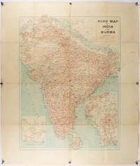
[INDIA - PRE PARTITION & BURMA - MAP]
Road Map of India and Burma.
Bombay.: Joshi & Co. circa1940. Colour lithographic map 66 x 50 cms; 81.x 68.5 cms sheet two inset maps and on the verso a full sheet "Relief Map of India" original folds with fold splits archivally strengthened several city names have been neatly underlined “Agartala” inked in the margin overall in good condition. Scarce Bombay-published map of the pre-Partition Indian sub-continent with two small inset maps one showing roads around Karachi and the other Burma. Through Routes Other Main Roads and Motorable Roads Subject to Weather are marked. The "Relief Map of India" on the verso includes Railway Lines Canals Steamer Routes Rivers Air Routes Navigable Canals and Broadcasting Stations. . Joshi & Co. unknown
书商的参考编号 : 211089
|
|
|
[INDIA - RAJASTHAN ANTIQUE MAP] SMITH, HM. (LITHOGRAPHER). H. M.
Rajpootana and Adjoining States Sheet No. 4.
Calcutta.: Surveyor Generals Office. 1870. Reissue of 1859 edition. Lithographed map 57.2 x 93 cms; 61.1 x 96 cms sheet original folds old paper repairs to the verso and a sealed marginal tear central folds archivally strengthened some toning to the folds and creasing but the map in remarkably good clean condition. Impressive large Calcutta printing from the Survey of India showing Rajasthan Uttar Pradesh and surrounding states with extremely detailed delineation of settlements roads railways rivers and major points of interest the Taj Mahal is highlighted. . Surveyor Generals Office. unknown
书商的参考编号 : 189711
|
|
|
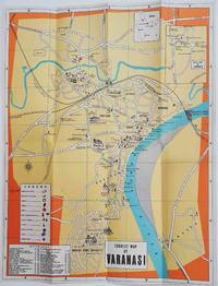
[INDIA - TOURIST MAP].
Tourist Map of Varanasi.
Circa1960. Folding colour tourist map of Varanasi in Uttar Pradesh province two inset maps of India and a gude map of Sarnath legend and key select Ghats shown railways "western style" and "Indian style" hotels marked in very good condition. 42.9 x 33.1 cm. . unknown
书商的参考编号 : 178269
|
|
|
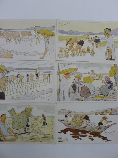
[INDOCHINE] - [CARTES POSTALES ANCIENNES] - [BOURDIN]
Le Riz d'Indo-Chine
Sans lieu, 1931. 1 ensemble de 6 cartes postales anciennes représentant les activités liées à la culture du riz en Indo-Chine.
书商的参考编号 : 8479
|
|
|
[INDOCHINE] [CARTES POSTALES ANCIENNES] [DIEULEFILS]
Cartes Postales anciennes du Tonkin
Hanoï, P. Dieulefils, Photographe-Editeur, vers 1900-1910. 1 album de cartes postales (114) consacrées au Tonkin et à Hanoï, ses monuments, ses rues, ses pagodes, ses édifices publics. La plupart des cartes sont animées, quelques-unes timbrées et oblitérées, très bon état d'ensemble.
书商的参考编号 : 10387
|
|
|
[INDOCHINE] [CARTES POSTALES ANCIENNES] [REGNAULT SARASIN]
Cartes postales anciennes sur l'Indochine
Paris, Editions du Figaro, sans date (1930?) 1 ensemble de 16 cartes postales anciennes représentant des scènes typiques indochinoises, des marchés, des monuments, des paysagesde l'Annam , du Tonkin, de la Cochinchine et du Cambodge, bon état.
书商的参考编号 : 12875
|
|
|
[INDOCHINE] [CARTES POSTALES ANCIENNES] [TETES COUPEES]
Indochine - Tonkin - Cartes postales anciennes
Indochine - Début du 20e siècle. 1 petit album cartonné comprenant 12 cartes postales anciennes timbrées. Ces carteséditées par Dieulefils ou par d'autres éditeurs, représentent des scènes de décapitation ou des têtes coupées de pirates tonkinois ou autres bandits de grands chemins. Curieux et insolite!
书商的参考编号 : 12876
|
|
|
[INDOCHINE] [RIZICULTURE] [CARTES]
Tonkin et Nord Annam - Cartes Rizicoles des Provinces au 1/250.000e
Hanoi, années 20. 1 ensemble de 18 cartes rizicoles des Provinces du Tonkin et Nord Annam, en parfait état, sous pochette.
书商的参考编号 : 6050
|
|
|
[INDOCHINE] [TONKIN] [CARTES POSTALES ANCIENNES] [DIEULEFILS]
Cartes Postales anciennes du Tonkin
Hanoï, P. Dieulefils, Photographe-Editeur, vers 1900-1910. 1 album de cartes postales (98) consacrées à Hanoï, ses monuments, ses rues, ses pagodes, ses édifices publics. Nombreuses cartes animées, quelques-unes timbrées et oblitérées, très bon état d'ensemble.
书商的参考编号 : 6191
|
|
|
[INDOCHINE] [VIETNAM [CARTES] [QUI NONN] [KANTUM] [DARLAC]
Carte de Qui Nonh
Paris, Avril 1945, Institut Géographique National. 1 grande carte, format 88*65 cm, à l'échelle 1/400.000e, en couleurs, dessinées par le S.G.M.A., publiées par l'Institut Géographique National en 1945., très bon état.
书商的参考编号 : 10423
|
|
|
[INDOCHINE] [VIETNAM [CARTES] [VINH]
Carte de Vinh Ouest
Paris, Avril 1945, Institut Géographique National. 1 grande carte, format 88*65 cm, à l'échelle 1/400.000e, en couleurs, dessinées par le S.G.M.A., publiées par l'Institut Géographique National en 1945., très bon état.
书商的参考编号 : 10422
|
|
|
[INDOCHINE] [VIETNAM [CARTES] [VINH]
Cartes de Vinh, Annam, Vinh Est et Vinh Ouest
Paris, Avril 1945, Institut Géographique National. 2 grandes cartes, format 88*65 cm, à l'échelle 1/400.000e, en couleurs, dessinées par le S.G.M.A., publiées par l'Institut Géographique National en 1945., très bon état.
书商的参考编号 : 8529

|
|
 ?????????
 ?????PDF???
 RSS feed


