|
PORCACCHI (Tommaso);
[ANGLETERRE] Descrittione dell'isola d'Inghilterra.
Venise 1576 104 x 142 mm.
Referentie van de boekhandelaar : LBW004f5
|
|
|
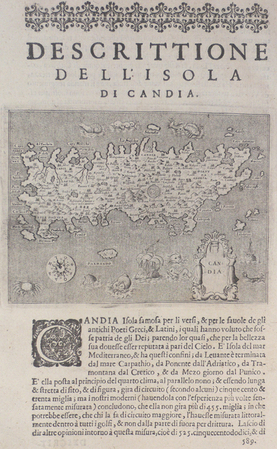
PORCACCHI (Tommaso);
[CRETE] Descrittione dell'isola di Candia.
Venise 1576 105 x 141 mm.
Referentie van de boekhandelaar : LBW004ef
|
|
|
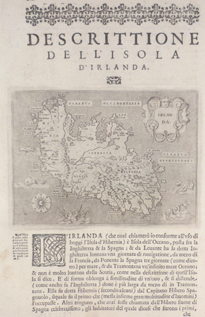
PORCACCHI (Tommaso);
[IRLANDE] Descrittione dell'isola d'Irlanda.
Venise 1576 104 x 141 mm.
Referentie van de boekhandelaar : LBW004f6
|
|
|
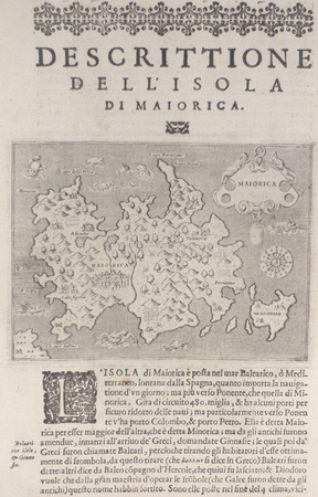
PORCACCHI (Tommaso);
[MAYORQUE] Descrittione dell'isola di Maiorica.
Venise 1576 104 x 143 mm.
Referentie van de boekhandelaar : LBW004f8
|
|
|
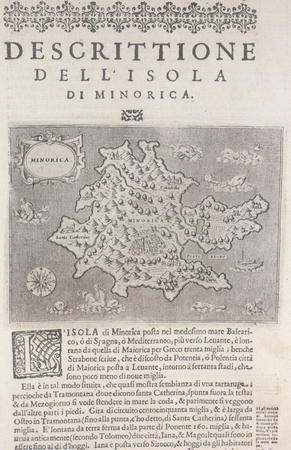
PORCACCHI (Tommaso);
[MINORQUE] Descrittione dell'isola di Minorica.
Venise 1576 105 x 142 mm.
Referentie van de boekhandelaar : LBW004f2
|
|
|
PORCACCHI (Tommaso);
[SARDAIGNE] Descrittione dell'isola di Sardigna.
Venise 1576 103 x 141 mm.
Referentie van de boekhandelaar : LBW004ed

|
|
|
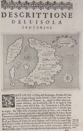
PORCACCHI (Tommaso);
[SANTORIN] Descrittione dell'isola Santorini.
Venise 1576 100 x 138 mm.
Referentie van de boekhandelaar : LBW004f3
|
|
|
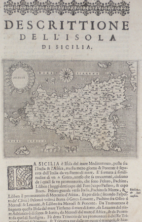
PORCACCHI (Tommaso);
[SICILE] Descrittione dell'isola di Sicilia.
Venise 1576 102 x 140 mm.
Referentie van de boekhandelaar : LBW004f9
|
|
|
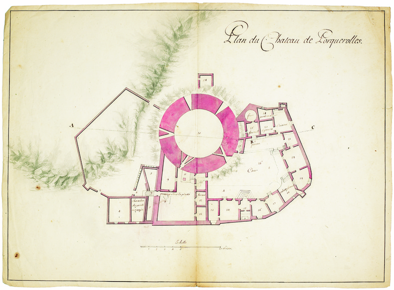
PORQUEROLLES. MANUSCRIT.
Plan du château de Porquerolles.
[circa 1750]. 390 x 555 mm.
Referentie van de boekhandelaar : LBW-4131
|
|
|
PORRET;
ROUEN (Seine-Inférieure).
Paris Benard circa 1850 225 x 304 mm.
Referentie van de boekhandelaar : LBW-1292

|
|
|
PORCACCHI Tommaso (1530 - 1585
Descritione del Mappamondo
Tratta da L'isole più famose del mondo (ed. 1620) in cui il Porcacchi (1530-1585) continua idealmente la tradizione iniziata da Cristoforo Buondelmonti con il primo isolario (manoscritto) risalente al 1420, seguito da quelli di Bartolomeo dalli Sonetti, Bordone e Camocio. In quest'opera vengono descritte tutte le isole conosciute al tempo, con la descrizione geografica e fisica, e con la presentazione degli usi e costumi degli abitanti.L'opera è, per la prima volta, pubblicata nel volume L’isole Piu Famose Del Mondo Descritte Da Thomaso Porcacchi Da Castiglione Aretino E Intagliate Da Girolamo Porro Padovan di Tommaso Porcacchi (ca. 1532-1576), umanista e letterato originario di Castiglion Fiorentino.Gli interessi geografici coltivati sin dal Pomponio Mela del 1557 diedero vita nel 1572 al trattato, pubblicato dalla società tra il libraio Simone Galignani e l’incisore padovano Girolamo Porro, che si servirono della tipografia di Giorgio Angelieri (con privilegio di 10 anni concesso il 16 luglio 1572). Secondo Valerio (cfr. Valerio-Spagnolo, Sicilia 1477-1861, La Collezione Spagnolo-Patermo in quattro secoli di Cartografia, 2014, p. 163) il volume sarebbe stampato nell’officina di Domenico e Giovan Battista Guerra. Il volume, in formato in quarto, con dedica di Galignani a don Giovanni d’Austria, presenta le magnifiche tavole calcografiche di Porro (una seconda edizione, cospicuamente accresciuta di testo e tavole, usci nel 1576, poi ancora, postume, nel 1590, 1604, 1605, 1620 e 1686). Nella lettera dedicatoria Porro narra di essere stato il promotore dell’operazione e di aver incaricato Porcacchi di scrivere un libro sulle isole, riservandosene l’illustrazione. Il modello e quello degli “isolari”, sul quale però Porcacchi innesta lo spirito delle corografie antiche, aggiungendo per ciascuna isola una descrizione fisica, storica e culturale. La concezione e molto ampia (sono comprese penisole, grandi isole come l’Inghilterra o interi continenti: l’America Settentrionale), ma nel “Prohemio” Porcacchi fornisce un glossario di termini geografici che testimonia lo sforzo di impiegare in maniera corretta la terminologia della disciplina (cfr. Franco Pignatti, Porcacchi Tommaso, in "Dizionario Biografico degli Italiani" - Volume 85, 2016). Nel testo vi sono mappe di isole incise su mezza pagina, compreso il planisfero – riduzione della carta murale di Camocio del 1567 e la “carta da navigare con le rotte e i venti, di derivazione gastaldina. Incisione in rame posta nella parte superiore del foglio che contiene anche la parte descrittiva, in ottimo stato di conservazione. Charming miniature map of the world on an oval projection, engraved by Girolamo Porro after a larger world map by Camoccio on the Gastaldi prototype. The huge mythical Terra Incognita dominates the Southern Hemisphere. On a full sheet (8.3 x 11.6") of Italian text with decorative capital letter below map and page 193 above. Italian text continues on the verso. A fine impression minor soiling outside the map.Map taken form L’isole Piu Famose Del Mondo Descritte Da Thomaso Porcacchi Da Castiglione Aretino E Intagliate Da Girolamo Porro Padovan by Tommaso Porcacchi (ca. 1532-1576), humanist and scholar from Castiglion Fiorentino. The geographical interests cultivated since Pomponio Mela in 1557 gave life to the treatise published in 1572 by the company between the bookseller Simone Galignani and the Paduan engraver Girolamo Porro, who used the typography of Giorgio Angelieri (with the privilege of 10 years July 1572). The volume, with a dedication by Galignani to Don Giovanni d'Austria, presents the magnificent calcographic plates by Porro (a second edition, conspicuously augmented with text and tables, came out in 1576, then again, posthumously, in 1590, 1604, 1605, 1620 and 1686). In the dedicatory letter Porro tells of having been the promoter of the operation and of having entrusted Porcacchi with writing a book on the islands, reserving the illustration. The model is that of the "isolari", on which however Porcacchi inserts the spirit of ancient chorographies, adding a physical, historical and cultural description for each island. The concept is very broad (including peninsulas, large islands such as England or entire continents: North America), but in the "Prohemio" Porcacchi provides a glossary of geographical terms that testifies to the effort to correctly use the terminology of the discipline (see Franco Pignatti, Porcacchi Tommaso, in "Dizionario Biografico degli Italiani" - Volume 85, 2016). In the text there are maps of islands engraved on half a page, including the planisphere - reduction of the wall map of Camocio of 1567 and the "carta marina”.Copperplate placed at the top of the sheet also including a descriptive part, in very good condition. R. W. Shirley, "The Mapping of the world", 127

|
|
|
PORRO GUTIERREZ, Jesús María.
Introducción a la Cartografía Histórica Americana. Prólogo de Luisa Martínez de Salinas Alonso.
Valladolid, 1999 4to. alargado; 166 pp Cubiertas originales.

|
|
|
Portal, Roger; Maps by Serge Bonin
Les Slaves: Peuples et Nations
France: Librairie Armand Colin 1965. Hardcover. Near fine/Very good. Gilt stamped green cloth boards in dust jacket octavo illustrated in b&w and color. Book has handsome boards and tight binding text clean and unmarked. DJ has mild edgewear that includes two small tears mild sun toning. Text in French. Librairie Armand Colin hardcover
Referentie van de boekhandelaar : B61904
|
|
|
PORTUGAL. Homann, Joh. B
Portugalliae et Algarbiae cum finitimis Hispaniae Regnis: Castiliae, Legionis, Andalusiae, Extrematurae, Galliciae & Granatae Novissima Tabula. Altkolorierte Kupferstichkarte.
Nürnberg, Johann Baptist Homann, [ca. 1730]. 1 grenzkolor. Karte von Portugal mit Teilen Westspaniens sowie NEBENKARTE der Überseebesitzung Brasilien "Regnum Brasiliae in America Australis" (20 x 20 cm), kolor. figürl. Titel- u. Wappenkartusche u. Meilenzeiger. Bildgröße ca. 49 x 57 cm. Mittelbugfalte.
Referentie van de boekhandelaar : 89168

|
|
|
Poste suisse:
10 timbres-poste - Vélo.
Berne, 2017. Feuille de 10 timbres de 1.-, en forme de vélo.
Referentie van de boekhandelaar : 23502

|
|
|
Poste suisse:
12 timbres-poste - Hornussen.
Feuille de 12 timbres de 1.-
Referentie van de boekhandelaar : 23505

|
|
|
Poste suisse:
20 timbres-poste - Hommage aux Selfies.
Berne, 2017. Feuille de 20 timbres de 1.-, effet miroir garanti !
Referentie van de boekhandelaar : 23503

|
|
|
Poste suisse:
4 séries spéciales de timbres-poste - Trains suisses. Brienz Rothorn Bahn - Train de la Schynige Platte - Train de la Wengernalp - Stanserhorn Bahn.
4 feuilles totalisant 34 timbres à 1.-
Referentie van de boekhandelaar : 23506

|
|
|
Poste suisse:
6 timbres-poste - Liebe-Amour-Amore-Love.
Berne, 2017. Feuille de 6 timbres de 1.-, en forme de coeur.
Referentie van de boekhandelaar : 23501

|
|
|
Poste suisse:
8 timbres-poste - Schweizer Jass - Jass suisse - Jass svizzero - Jass zwizzer.
Berne, 2025. Feuille de 8 timbres de 1.-
Referentie van de boekhandelaar : 23504

|
|
|
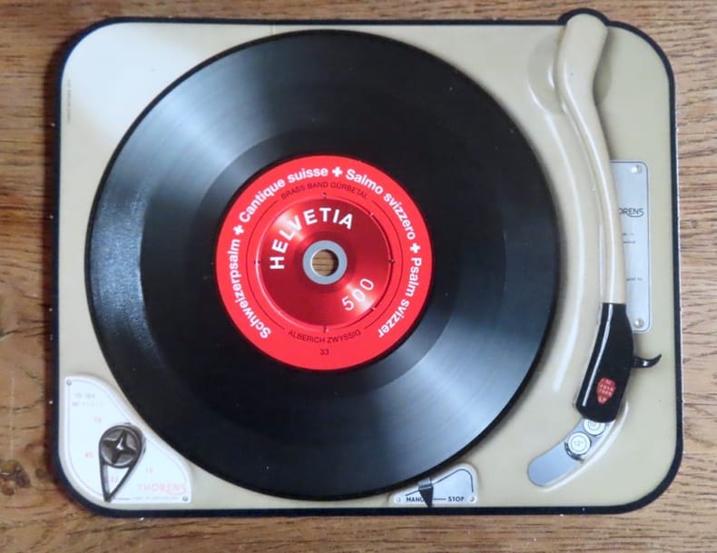
Poste suisse:
Timbre sonore. Schweizerpsalm - Cantique suisse - Salmo svizzero - Psalm sviszzer, Hymne national suisse.
Poste Suisse, 2014. Timbre à la valeur faciale de 5.-, sur un carton au format 17 x 13,5 cm. Très très léger pli à un bord, la rondelle centrale commence à se détacher, en très bon état néanmoins.
Referentie van de boekhandelaar : 20821
|
|
|
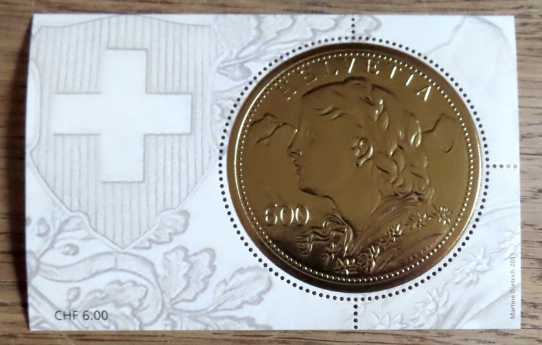
Poste suisse:
«Goldvreneli» – Bloc spécial avec timbre-poste à CHF 6.00.
Poste Suisse, 2014. Timbre circulaire (5,6 cm.), feuille au format 10,7 7 cm. Valeur faciale 6.-
Referentie van de boekhandelaar : 20822
|
|
|
postcards, postkaarten, wenskaarten
kaartenmolen voor post / wens kaarten van 15cm x10.5cm.
Hoogte molen: minimale hoogte 143cm maximale hoogte 190cm. ,Doorsnede molen: ? 400mm. Vuldiepte: 25mm. volledig nieuw uit voorraad leverbaar. 30 Pockets 119mm LIGGEND + 21 Pockets 110mm STAAND. grijs gelakt.

|
|
|
Postgate, JF. Horrabin (maps Wells H. G.; Raymond (revision and new material) J. F.
The Outline of History : Volume I
US: Garden City Books 1961. Garden City Books 1961 Very Good/ Volume 1 ONLY. Light wear to red cloth. NO DUST JACKET. Upper page edges dyed red and slightly faded. Inside page edges are deckled. tight bright illustrated pages. HEAVY ITEM 1.34 Pounds. Size: 8 1/2 x 5 5/8 x 1 1/2 inches. . Hardcover. Very Good. No Exp. Garden City Books Hardcover
Referentie van de boekhandelaar : 2000041220
|
|
|
Postkarte/ Ansichtskarte / Künstlerkarte / Carte postale
Adolf Reich, Kunst- und Naturfreund. Nr. 148, München, Haus der Kunst.
Um 1940. 15 x 10,5 cm.
Referentie van de boekhandelaar : 3843B

|
|
|
Postkarte/ Ansichtskarte / Künstlerkarte / Carte postale
Arno Breker, "Psyche". Nr. 24, München, Haus der Kunst.
Um 1940. 15 x 10,5 cm.
Referentie van de boekhandelaar : 3832B

|
|
|
Postkarte/ Ansichtskarte / Künstlerkarte / Carte postale
Arno Breker, Schreitende. Nr. 36, München, Haus der Kunst.
Um 1940. 15 x 10,5 cm.
Referentie van de boekhandelaar : 3845B

|
|
|
Postkarte/ Ansichtskarte / Künstlerkarte / Carte postale
Barbara von Kalckreuth, Träumerei. Nr. 352, München, Haus der Kunst.
Um 1940. 15 x 10,5 cm.
Referentie van de boekhandelaar : 3841B

|
|
|
Postkarte/ Ansichtskarte / Künstlerkarte / Carte postale
Ernst Liebermann, Naja an der Quelle. Nr. 408, München, Haus der Kunst.
Um 1940. 15 x 10,5 cm.
Referentie van de boekhandelaar : 3840B

|
|
|
Postkarte/ Ansichtskarte / Künstlerkarte / Carte postale
Jacob V. Fehrle, Diana. Nr. 327, München, Haus der Kunst.
Um 1940. 15 x 10,5 cm.
Referentie van de boekhandelaar : 3842B

|
|
|
Postkarte/ Ansichtskarte / Künstlerkarte / Carte postale
Jak. Wilh. Fehrle, Tänzerin. Nr. 473, München, Haus der Kunst.
Um 1940. 15 x 10,5 cm.
Referentie van de boekhandelaar : 3837B

|
|
|
Postkarte/ Ansichtskarte / Künstlerkarte / Carte postale
Joh Schult, Erwartung. Nr. 507, München, Haus der Kunst.
Um 1940. 15 x 10,5 cm.
Referentie van de boekhandelaar : 3835B

|
|
|
Postkarte/ Ansichtskarte / Künstlerkarte / Carte postale
Johann Schult, Im Lebensfrühling. Nr. 411, München, Haus der Kunst.
Um 1940. 15 x 10,5 cm.
Referentie van de boekhandelaar : 3839B

|
|
|
Postkarte/ Ansichtskarte / Künstlerkarte / Carte postale
Josef Thorak. Leda mit dem Schwan. München, Haus der Kunst.
Um 1940. 15 x 10,5 cm.
Referentie van de boekhandelaar : 3833B

|
|
|
Postkarte/ Ansichtskarte / Künstlerkarte / Carte postale
Konstantin Gerhardinger, Modell-Pause. Nr. 448, München, Haus der Kunst.
Um 1940. 15 x 10,5 cm.
Referentie van de boekhandelaar : 3838B

|
|
|
Postkarte/ Ansichtskarte / Künstlerkarte / Carte postale
M. Alfred Brumme, Die Belebende. Nr. 497, München, Haus der Kunst.
Um 1940. 15 x 10,5 cm.
Referentie van de boekhandelaar : 3836B

|
|
|
Postkarte/ Ansichtskarte / Künstlerkarte / Carte postale
Prof. Richard Scheibe, Der Morgen. Nr. 58, München, Haus der Kunst.
Um 1940. 15 x 10,5 cm.
Referentie van de boekhandelaar : 3844B

|
|
|
Postkarte/ Ansichtskarte / Künstlerkarte / Carte postale
Sepp Hilz, Eitelkeit. München, Haus der Kunst.
Um 1940. 15 x 10,5 cm.
Referentie van de boekhandelaar : 3834B

|
|
|
POTIQUET (Alfred).
[CHEMINS de FER] Carte spéciale du réseau des chemins de fer de Paris à Lyon et à la Méditerranée, dressée par ordre de MM. les membres des Conseils d'administration.
1869. En 36 sections montées sur toile et repliées, formant une carte de 1,46 x 1,04 m ; étiquette au dos de l'atelier d'Entoilage et Vernissage de Plans et Cartes Géographiques de A. Corion à Paris, successeur de H. Dorlin ; sous chemise et étui de chagrin vert, filet doré en encadrement sur les plats de l'étui, titre en lettres dorées au dos.
Referentie van de boekhandelaar : LBW-8940

|
|
|
Potter, Jonathan
Country Life Book of Antique Maps - An Introduction to the History of Maps and How to Appreciate Them
192 pages including bibliography and index. A thorough introduction to the history of antique maps and how to collect and enjoy them, written by one of the world's leading antique map dealers. Wonderfully illustrated in colour. Text divided into three sections: Looking at Maps; Mapping the World and It's Countries; Globes, Curiosities and Miniatures. Book is clean, bright and unmarked with very light wear to reddish boards. Moderate wear to attractive dust jacket which bears two closed tears, each under a half-inch in length, to top edge of back panel. Nice copy. Book
|
|
|
POURCHER (François).
Carte des chaînes de montagnes de la France, de ses principales rivières, et des principaux canaux de navigation, faits, ou à faire, dans ce royaume.
1782. 435 x 398 mm.
Referentie van de boekhandelaar : LBW-5895

|
|
|
POUQUEVILLE François-Charles-Hugues-Laurent:
Grèce.
Paris, Firmin Didot frères, 1835. In-8 de [4]-447-[1] pages, demi-chagrin rouge, dos lisse orné de fers romantique dorés, tranches marbrées.
Referentie van de boekhandelaar : 21047

|
|
|
POUQUEVILLE François-Charles-Hugues-Laurent:
Voyage de la Grèce avec cartes, vues et figures.
Paris, Firmin-Didot, 1826. 6 volumes in-8 de [4]-LXXVIII-[2]-418; [4]-524; [4]-552; [4]-511; [4]-624; [4]-481 pages, demi-basane chamois, dos lisses ornés de fers romantiques. Bel exemplaire non rogné.
Referentie van de boekhandelaar : 16419
|
|
|
Powell, J. W
TWELFTH ANNUAL REPORT OF THE UNITED STATES GEOLOGICAL SURVEY TO THE SECRETARY OF THE INTERIOR 1890-'91. Part 1 - GEOLOGY.
Washington, Government Printing Office, 1891. 4°. With many plates, illustrations and maps, 6 folding pocket maps. 675 pp. Original gold stamped cloth. Mit zahlreichen Tafeln, Textabbildungen und Karten, 6 Faltkarten in Anhangtasche. Orig.-Leinen mit Deckelvergoldung, Rückengoldprägung. - Content: The origin and nature of soils; The lafayette formation; The north american continent during cambrian time; The eruptive rocks of electric peak and sepulchre mountain, yellowstone national park etc. Binding scratched. Einband berieben.
Referentie van de boekhandelaar : 5664

|
|
|
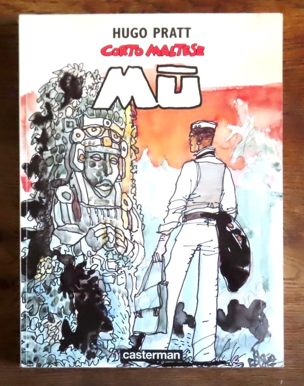
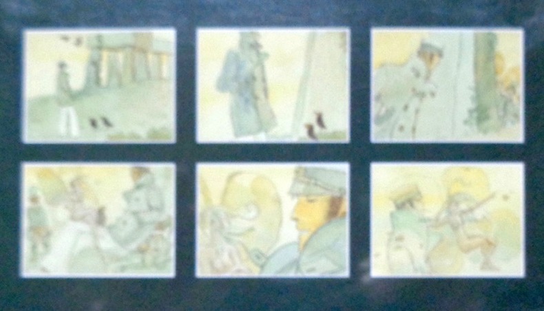
Pratt Hugo:
Corto Maltese - Mû.
Casterman, 1979. In-4 broché, couverture couleurs, très légèrement défraîchie (plis de lecture au dos).
Referentie van de boekhandelaar : 19799
|
|
|
Pratt Hugo:
Corto Maltese. La cour secrète des Arcanes. . . en 36 cartes.
Christian Desbois. Jeu de 36 cartes au format 7,5 x 12 cm, feuillet dépliant illustré, sous boîte couleurs. Frottements en bords de la boîte.
Referentie van de boekhandelaar : 23076

|
|
|
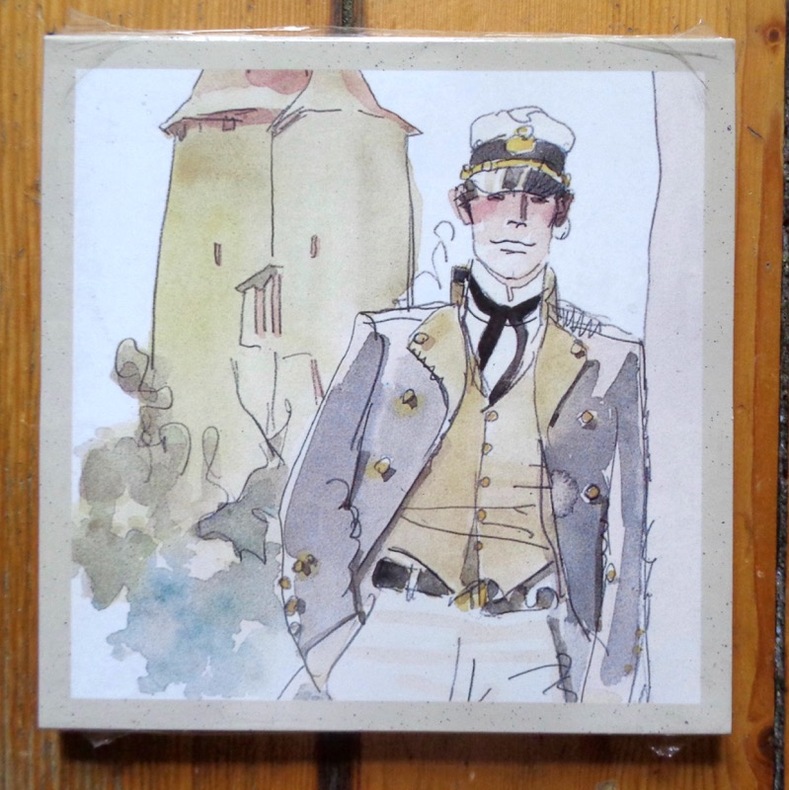
Pratt Hugo:
Les Helvétiques.
Casterman, 1997. 6 cartes doubles avec enveloppes, sous pochette illustrée. A l'état de neuf, sous emballage d'origine.
Referentie van de boekhandelaar : 6239
|
|
|
Pratt Hugo:
Les Celtiques.
Casterman, 1996. 6 cartes doubles avec enveloppes, sous pochette illustrée. A l'état de neuf, sous emballage d'origine.
Referentie van de boekhandelaar : 6240
|
|
|
PRESTIDIGITATION - CARTES
Etui en deux parties coulissantes en carton (24 x 16,5 cm) vers 1900, au centre évidé et contenant une grande carte à jouer, elle-même évidée au centre, représentant tête bêche deux reines, et une demi carte, coulissant dans sa demi-partie, identique à une moitie de la grande carte
Referentie van de boekhandelaar : 16749

|
|
|
PREVOST Abbé
Histoire Générale Des Voyages, Ou Nouvelle Collection De Toutes Les Relations De Voyages Par Mer et Par Terre, Qui Ont été Publiées jusqu'à Présent Dans Les Différentes Langues De Toutes Les Nations Connues ; Contenant (.....) Enrichi De Cartes ...
Paris Didot 1746 In-12 ( 4 Volumes ) 1 portrait LXXXIV - 362 pp ( 2 gravures dép et 2 cartes ) + 450 ( 1 gravures, 1 plan et 4 cartes dépliantes ) + 466 pp ( 1 gravure et 2 cartes dépliantes ) + 360 ( 1 carte dépliante , 4 planches dépliantes ) Tête de Collection en plein maroquin vert , triples filets dorés encandrant les plats, tranches dorées
Referentie van de boekhandelaar : 23229
|
|
 De zoekresultaten per email ontvangen
 Zoekresultaten downloaden als PDF
 RSS feed


