|
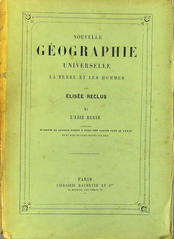
RECLUS Elisée 8 cartes en couleurs, 182 cartes dans le texte. Nombreuses gravures.
Nouvelle géographie universelle. La terre et les hommes. VI : L'Asie russe.
Couverture souple. Broché. 919 pages. 19 x 28 cm. Rousseurs. Dos réparé.
书商的参考编号 : 130812
|
|
|
Reclus, (Jean-Jacques-) Elisee.
THE EARTH: A DESCRIPTIVE HISTORY OF THE PHENOMENA OF THE LIFE OF THE GLOBE. Translated by the Late B. B. Woodward and Edited by Henry Woodward, British Museum.
pp. 573 + Publisher's ads (2p.) + 23 color maps. Illustrated with 230 text maps and drawings. 8vo. 24 cm. Worn original publisher's green cloth binding. LOC?
|
|
|
Red Maps
Madrid & Sevilla Street Map and City Guide
NEW. unknown
书商的参考编号 : BIB-NOV-14-2025-66311 ???????? : 1892238942 9781892238948
|
|
|
Red Maps
Red Map Brooklyn with Long Island City - City Travel Guide
2016-12-01. 2016. map. New. 5.29x0.06x3.18. Buy with confidence. Excellent Customer Service & Return policy. unknown
书商的参考编号 : DADAX1892238861 ???????? : 1892238861 9781892238863
|
|
|
Red Maps
Red Map Los Angeles City Travel Guide
Red Maps 2017-01-01. map. Good. 4x0x8. Travel guide brochure is pre-owned and in good shape with minimal to some signs of wear or use . An entirely readable and usable copy! Red Maps unknown
书商的参考编号 : TZVI-gs-LATravel-062123- ???????? : 1892238799 9781892238795
|
|
|
Red Maps
Red Map New York City City Travel Guide
2017-04-01. 2017. map. New. 5.15x0.06x3.27. Buy with confidence. Excellent Customer Service & Return policy. unknown
书商的参考编号 : DADAX1892238802 ???????? : 1892238802 9781892238801
|
|
|
Red Maps
Red Map New York City City Travel Guide
2017-04-01. 2017. map. Used: Good. 5.15x0.06x3.27. Buy with confidence. Excellent Customer Service & Return policy. unknown
书商的参考编号 : SONG1892238802 ???????? : 1892238802 9781892238801
|
|
|
Red Maps
Red Map Philadelphia City Travel Guide
2017-01-01. map. New. 9.17x0.06x3.58. Buy with confidence. Excellent Customer Service & Return policy. unknown
书商的参考编号 : DADAX1892238993 ???????? : 1892238993 9781892238993
|
|
|
Red Maps
Red Map Soho-Nolita & Little Italy NYC - City Travel Guide
Paperback. Very Good. paperback
书商的参考编号 : GOR011034021 ???????? : 1892238845 9781892238849
|
|
|
Red Maps
Red Maps CHICAGO Street Map and City Guide
map. Good. Access codes and supplements are not guaranteed with used items. May be an ex-library book. unknown
书商的参考编号 : 1892238853.G ???????? : 1892238853 9781892238856
|
|
|
Red Maps
Red Maps LONDON Street Map and City Guide
Paperback. Very Good. paperback
书商的参考编号 : GOR013673933 ???????? : 1892238888 9781892238887
|
|
|
Red Maps
Red Maps SAN FRANCISCO Street Map and City Guide
map. Good. Access codes and supplements are not guaranteed with used items. May be an ex-library book. unknown
书商的参考编号 : 1892238772.G ???????? : 1892238772 9781892238771
|
|
|
Red Maps
Red Maps WASHINGTON DC Street Map and City Guide
map. Good. Access codes and supplements are not guaranteed with used items. May be an ex-library book. unknown
书商的参考编号 : 1892238780.G ???????? : 1892238780 9781892238788
|
|
|
Red Maps (Firm)
Amsterdam
Red Maps Firm 2012. Map. New. 2013 edition. 1 pages. 9.30x4.00x0.40 inches. Red Maps (Firm) unknown
书商的参考编号 : 1-1892238918 ???????? : 1892238918 9781892238917
|
|
|
Red Maps (Firm)
Barcelona
map. Good. Access codes and supplements are not guaranteed with used items. May be an ex-library book. unknown
书商的参考编号 : 1892238705.G ???????? : 1892238705 9781892238702
|
|
|
Red Maps (Firm)
Berlin/Potsdam
map. Good. Access codes and supplements are not guaranteed with used items. May be an ex-library book. unknown
书商的参考编号 : 1892238489.G ???????? : 1892238489 9781892238481
|
|
|
Red Maps (Firm)
Florence
map. Good. Access codes and supplements are not guaranteed with used items. May be an ex-library book. unknown
书商的参考编号 : 1892238608.G ???????? : 1892238608 9781892238603
|
|
|
Red Maps (Firm)
Las Vegas
map. Good. Access codes and supplements are not guaranteed with used items. May be an ex-library book. unknown
书商的参考编号 : 1892238640.G ???????? : 1892238640 9781892238641
|
|
|
Red Maps (Firm)
Madrid & Sevilla
Red Maps Firm 2012. Map. New. 2013 edition. 1 pages. 9.40x3.90x0.10 inches. Red Maps (Firm) unknown
书商的参考编号 : 1-1892238942 ???????? : 1892238942 9781892238948
|
|
|
Red Maps (Firm)
Philadelphia
map. Good. Access codes and supplements are not guaranteed with used items. May be an ex-library book. unknown
书商的参考编号 : 1892238403.G ???????? : 1892238403 9781892238405
|
|
|
Red Maps (Firm)
Venice
Red Maps Firm 2008. Map. New. 1 pages. 9.20x3.50x0.10 inches. Red Maps (Firm) unknown
书商的参考编号 : 1-1892238748 ???????? : 1892238748 9781892238740
|
|
|
Red Maps (Firm)
Venice Map and City Guide
map. Good. Access codes and supplements are not guaranteed with used items. May be an ex-library book. unknown
书商的参考编号 : 1892238748.G ???????? : 1892238748 9781892238740
|
|
|
Redding, M. Wolcott.
ANTIQUITIES OF THE ORIENT UNVEILED. A Concise Description of the Ruins of King Solomon's Cities.
pp. 541, (3) [Publisher's catalogue] + Color lithograph folding map of Jerusalem and Color lithograph Frontis + Ninety full page engravings. Map has 1 1/2" tear in left margin with no loss. Some engravings have dampstaining in margins. Text elaborately ruled throughout. Lacks front and rear marbled fly leaves. 225mm. Front board detached. Spine very worn. Virtually disbound. This perhaps should best be considered a candidate for rebinding. **PRICE JUST REDUCED! HOLY LAND BX 1
|
|
|
Redgrave, J J ; Serton, P (ed) ; Paulick, H (maps and drawings by)
Our Friends Across the Sea - Europe Revised and Enlarged
Maskew Miller Limited Cape Town. 2nd Edition. Soft cover. Poor/No Jacket. 112 pages complete. In general poor to fair condition. No marked publication date but judging from the womens' hats and clinched waists we can assume this to be about '52/ '53/ '54. It should be remarked that the illustrations for all nations in Western Europe are photographic. Those for the Soviet Union are propaganda shots for all other Eastern Block countries illustrations are by drawing only! The book is scruffy and worn. The covers are worn marked creased stained stoically cheerful. The spine is secure tenacious very worn. The contents are worn about the edges. There are previous owner annotations to fore and aft. The contents are benign amiable comfortable against the binding. The pages are clear clean tidy and assured. fk. Our orders are shipped using tracked courier delivery services. Maskew Miller Limited, Cape Town paperback
书商的参考编号 : atpu

|
|
|
REED KILNE, Naomi.
Maps of Medieval Thought.
Suffolk, The Boydell Pres 2001, 240x170mm, XIII - 261pages, paperback. Book in good condition.
书商的参考编号 : 89919

|
|
|
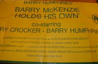
Reg Grundy Productions; Bruce Beresford (director & producer); MAPS Litho Pty. Ltd (litho).
Barry Humphries' 'Barry McKenzie Holds His Own'.
Sydney Australia: Reg Grundy Productions 1974. Lithograph Poster. 40" x 20.5" Folded Poster Good with some minor tears at edges. [Sydney], Australia: Reg Grundy Productions, 1974. unknown
书商的参考编号 : 68-0786
|
|
|
Regards. Gérant : Zeyons
Regards En couverture : Les dessous des cartes. Révélations sur la presse françaiseM. Boussac - M. Dubridet veut fonder un journal (Louis Maréchot) - Les journaux communistes et démocratiques mènent l'offensive - Au service de la vérité (Serge Zeyons, photos Jacques Kanapa) - Les journaux qui vous défendent, vous conseillent, vous distraient - Des ouvriers imprimeurs vous racontent (eux-même) la naissance de "Regards" - Le journal des lecteurs. L'insigne, nouvelle de Paul Saux - Travailleurs de France - Gosses de Paris et d'ailleurs - Akoutou, et le préjugé du Zoe, nouvelle de Fozoo Ekabe (Cameroun) - Vallauris la pacifique (reportage photo André Villers) - Poèmes pour la paix - Une petite ville - Dans le monde des champignons - ...
n° 371 - novembre 1953 - nouvelle série - revue illustrée - in-4 broché - 50 pages
书商的参考编号 : 60930
|
|
|
REGNE Jean
R?pertoire des plans cadastraux parcellaires de l'Ard?che. Lettre-pr?face de Marc Bloch.
Broch?. 70 pages. Couverture en mauvais ?tat. Importantes rousseurs.
|
|
|
REGUIN Olivier:
Saint-Georges. Village, prieuré et seigneurie à la fin du Moyen Age.
Lausanne, Bibliothèque Historique Vaudoise, 2000. In-8 broché de 219 pages, couverture illustrée en couleurs.
书商的参考编号 : 1104

|
|
|
Reich, Erhard - Ortelius, Abraham
Palatinatus Bavariae descriptio, Erhardo Reych Tirolense Auctore. [um 1590]. [Altkolorierter Original-Kupferstich, gerahmt / old colored original copper engraving, framed]
o.J. Abraham Ortelius, geboren am 4. oder 14. April 1527 in Antwerpen, gestorben am 28. Juni 1598 ebenda. Flämischer Geograph und Kartograf. [3 Warenabbildungen]
书商的参考编号 : 59507BB

|
|
|
REICH, HANS/ VALK, MAPS.
KINDEREN UIT HEEL DE WERELD.
Den Haag Nederlandse Boekenclub 1958. . Gebonden originele geillustreerde uitgeversomslag in kleur 185x235cm 119pp rijkelijk geillustreerd z/w. Den Haag, Nederlandse Boekenclub, 1958. unknown
书商的参考编号 : 9746
|
|
|
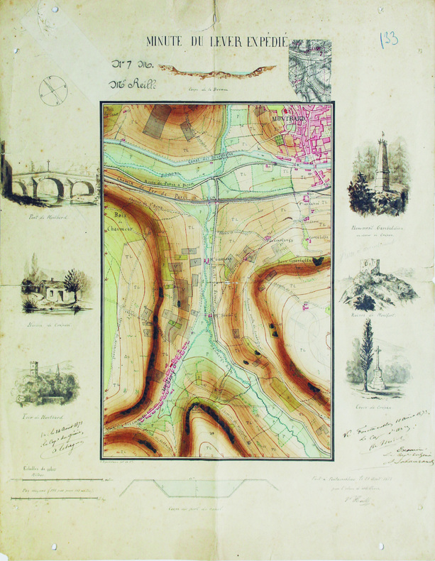
REILLE (Victor).
Minute du lever expédié.
Fontainebleau, 1871. 47,8 x 38,3 cm.
书商的参考编号 : LBW-6565
|
|
|
Reilly, Franz Johann Joseph von
Das Herzogthum Geldern. Kurbrandenburgischen Antheils mit dem Fürstenthume Mörs. Nro. 268 (um 1790). [Altkolorierter Kupferstich, gerahmt / handcoloured copper engraving, framed].
o.J. [3 Warenabbildungen] (Franz Johann Joseph von Reilly, geb. 18.08.1766 in Wien, gest, 06.07.1820 ebenda, österreichischer Verleger, Kartograf
书商的参考编号 : 66102CB

|
|
|
Reilly, Franz Johann Joseph von
Das Koenigreich Sklavonien und Herzogthum Syrmien (No. 3). Teilkolorierte Kupferstichkarte aus "Schauplatz der fünf Theile der Welt".
Wien, Reilly, ca. 1789. 20 x 29 cm (Blattgröße 22 x 32 cm).
书商的参考编号 : 110609

|
|
|
Reilly, Franz Johann Joseph von
Der gefürsteten Grafschaft Tirol Viertel Unterinn und Wipp-Thal. Teilkolorierte Kupferstichkarte (No. 146) aus "Schauplatz der fünf Theile der Welt".
Wien, Reilly, ca. 1791. 22 x 29 cm (Blattgröße 24 x 32 cm).
书商的参考编号 : 110618

|
|
|
Reilly, Franz Johann Joseph von:
Das Koenigreich Sklavonien und Herzogthum Syrmien (No. 3). Teilkolorierte Kupferstichkarte aus "Schauplatz der fünf Theile der Welt".
20 x 29 cm (Blattgröße 22 x 32 cm). *Reilly ist bekannt für seine exakten Detailkarten, die vorliegende Karte Slowenien mit Belgrad im Osten und die Kleine Walachei mit Kialiova im Westen (linke Ecke oben mit leichtem Fleck). - Map from the Atlas of Reilly`s "Schauplatz der fünf Theile der Welt", which appeared 1789 to 1806 in 3 parts with more than 1000 maps of Europe. This atlas is famous for his exact and detailed maps. - Original copperplate engraving [Vienna, about 1789]. Some original colouring, good condition. Landkarten de
|
|
|
Reilly, Franz Johann Joseph von:
Der gefürsteten Grafschaft Tirol Viertel Unterinn und Wipp-Thal. Teilkolorierte Kupferstichkarte (No. 146) aus "Schauplatz der fünf Theile der Welt".
22 x 29 cm (Blattgröße 24 x 32 cm). *Reilly ist bekannt für seine exakten Detailkarten, die vorliegende Karte zeigt das Österreichische Teilgebiet Unterinn mit Kufstein im Norden. - Map from the Atlas of Reilly`s "Schauplatz der fünf Theile der Welt", which appeared 1789 to 1806 in 3 parts with more than 1000 maps of Europe. This atlas is famous for his exact and detailed maps. - Original copperplate engraving [Vienna, 1789]. Some original colouring, good condition. Landkarten de
|
|
|
Reilly, Franz Johann Joseph von:
Die Markgrafschaft Niederlausitz chursächsischen und preussischen Antheils und in ihre Kreise eingetheilt. Nro 104"
22 x 29 cm. Blattgröße 30 x 42 cm. Teilkolorierte Kupferstichkarte. *Reilly ist bekannt für seine exakten Detailkarten, die vorliegende Karte zeigt das Gebiet der Niederlausitz mit Lübben, Spreewald, Cottbus und Guben. Aus dem Werk "Aus: Schauplatz der fünf Theile der Welt". - Sehr gut erhalten. Landkarten de
|
|
|
Reilly, Franz Johann Joseph von:
Generalkarte von Spanien und Portugal. Landkarte No. 524 aus dem Atlas von Reilly "Schauplatz der fünf Theile der Welt" (1789-1806).
23 x 28 cm (Blattgröße 33 x 52 cm). Teilkolorierte Kupferstichkarte. *Reilly ist bekannt für seine exakten Detailkarten, die vorliegende Karte zeigt die gesamte Iberische Halbinsel. - Sehr gut erhalten. - Map from the Atlas of Franz Johann Joseph von Reilly "Schauplatz der fünf Theile der Welt", which appeared 1789 to 1806 in 3 parts with more than 1000 maps of Europe. This atlas is famous for his exact and detailed maps. Here one map of the Iberian part - No. 524 (General map of Spain and Portugal). - Fine condition. Landkarten de
|
|
|
Reilly, Franz Johann Joseph von:
Karte von dem Königreiche Slavonien. Neunzehende Schulkarte ... aus "Schul Atlas" herausgegeben von F.I.I. von Reilly und zu finden im Verlage des Herausgebers.
Blattgröße 30 x 44,5 cm. Teilkolorierte Kupferstichkarte. *Reilly ist bekannt für seine exakten Detailkarten, die vorliegende Karte zeigt das gesamte Slavonien in Flächenkolorit. - Karte aus dem Schul-Atlas "Schulkarte zu ... der Erdbeschreibung zum Gebrauche der studirenden Jugend in den Kaiserlichen Königlichen Staaten". Dieser frühe Österreichische Schulatlas wurde von dem Landkartenstecher Reilly angefertigt und ist recht selten. Die Karten sind hier etwas größer als in seinem gleichzeitig begonnenen Hauptwerk "Schauplatz ...". - Leicht gebräunt, insgesamt gut erhalten. Landkarten de
|
|
|
Reilly, Franz Johann Joseph von:
Karte von den Königreichen Gallizien und Lodomerien den Herzogthümern Auschwitz und Zator und der Landschaft Bukovina. Zwanzigste Schulkarte ... aus "Schul Atlas" herausgegeben von F.I.I. von Reilly und zu finden im Verlage des Herausgebers.
Blattgröße 30 x 44,5 cm. Teilkolorierte Kupferstichkarte. *Reilly ist bekannt für seine exakten Detailkarten, die vorliegende Karte mit Grenz- und Flächenkolorit. - Karte aus dem Schul-Atlas "Schulkarte zu ... der Erdbeschreibung zum Gebrauche der studirenden Jugend in den Kaiserlichen Königlichen Staaten". Dieser frühe Österreichische Schulatlas wurde von dem Landkartenstecher Reilly angefertigt und ist recht selten. Die Karten sind hier etwas größer als in seinem gleichzeitig begonnenen Hauptwerk "Schauplatz ...". - Leicht gebräunt, insgesamt gut erhalten. Landkarten de
|
|
|
Reilly, Franz Johann Joseph von:
Karte von Europa überhaupt und der Östreichischen Monarchie insbesondere. Zweyte Schulkarte ... aus "Schul Atlas" herausgegeben von F.I.I. von Reilly und zu finden im Verlage des Herausgebers.
Blattgröße 30 x 44,5 cm. Teilkolorierte Kupferstichkarte. *Reilly ist bekannt für seine exakten Detailkarten, die vorliegende Karte zeigt Europa. - Karte aus dem Schul-Atlas "Schulkarte zu ... der Erdbeschreibung zum Gebrauche der studirenden Jugend in den Kaiserlichen Königlichen Staaten". Dieser frühe Österreichische Schulatlas wurde von dem Landkartenstecher Reilly angefertigt und ist recht selten. Die Karten sind hier etwas größer als in seinem gleichzeitig begonnenen Hauptwerk "Schauplatz ...". - Sehr gut erhalten. Landkarten de
|
|
|
Reilly, Franz Johann Joseph von:
Karte von Oberhungarn in die zween Kreise diesseits und jenseits der Theyss abgetheilt. Siebenzehende Schulkarte ... aus "Schul Atlas" herausgegeben von F.I.I. von Reilly und zu finden im Verlage des Herausgebers.
Blattgröße 30 x 44,5 cm. Teilkolorierte Kupferstichkarte. *Reilly ist bekannt für seine exakten Detailkarten, die vorliegende Karte zeigt das östliche Ungarn. - Karte aus dem Schul-Atlas "Schulkarte zu ... der Erdbeschreibung zum Gebrauche der studirenden Jugend in den Kaiserlichen Königlichen Staaten". Dieser frühe Österreichische Schulatlas wurde von dem Landkartenstecher Reilly angefertigt und ist recht selten. Die Karten sind hier etwas größer als in seinem gleichzeitig begonnenen Hauptwerk "Schauplatz ...". - Leicht gebräunt, insgesamt gut erhalten. Landkarten de
|
|
|
Reilly, Franz Johann Joseph von:
Karte von Oberoestreich oder der Grafschaft Tirol. Sechste Schulkarte ... aus "Schul Atlas" herausgegeben von F.I.I. von Reilly und zu finden im Verlage des Herausgebers.
Blattgröße 29,5 x 40 cm. Teilkolorierte Kupferstichkarte. *Reilly ist bekannt für seine exakten Detailkarten, die vorliegende Karte zeigt Gebiet Tirol vom von der Bayerischen und Schwäbischen Grenze im Norden bis zum Gardasee im Süden mit leichtem Grenz- und Flächenkolorit. - Karte aus dem Schul-Atlas "Schulkarte zu ... der Erdbeschreibung zum Gebrauche der studirenden Jugend in den Kaiserlichen Königlichen Staaten". Dieser frühe Österreichische Schulatlas wurde von dem Landkartenstecher Reilly angefertigt und ist recht selten. Die Karten sind hier etwas größer als in seinem gleichzeitig begonnenen Hauptwerk "Schauplatz ...". - Sehr gut erhalten. Landkarten de
|
|
|
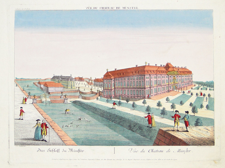
REINHOLD (Christian Ludolph) & LEIZELT (Balthasar Friedrich).
[MÜNSTER] Vüe du château de Münster.
Augsbourg, Négoce commun de l'Académie Impériale d'Empire des Arts Libéraux, [circa 1790]. 307 x 400 mm.
书商的参考编号 : LBW-2792
|
|
|
REMIREMONT
Carte d'Etat-Major au 1/200 000e. Fin XIXe.
1 feuille repli?e. 32x49 cm.
|
|
|
Remond (Martial) :
La Kabylie. Préface de Marcel Larnaude. Ouvrage orné de 16 hors-texte et de 17 cartes et itinéraires. Dessins de Mme Kleiss-Herzig - Photos de l'auteur.
Alger, Editions Baconnier, 1937 ; in-8 (205 mm), broché ; 157, [1] pp., 16 ff. hors-texte de photographies en héliogravures, portraits, scènes et paysages, couverture illustrée d'un portrait en couleur par Mme Yvonne Kleiss-Herzig.
书商的参考编号 : 20384

|
|
|
REMONDINI Tipografia (Bassano 1650 - 1860)
Carte generale du globe terrestre construite & publiee par le S.r Jsaac Brouckner geographe de S.M.I.C. exaninee & approuvee
Raro planisfero pubblicato a Venezia dalla tipografia Remondini ed occasionalmente inserito nel Dizionario geografico portatile, 1761.Interessante mappa del mondo presentata nella proiezione di Mercator e centrata sull'Australia.La Groenlandia è mostrata collegata al Nord America. Il titolo riporta che la mappa fu approvata da Daniel Bernoulli (1700-1782), medico, fisico e matematico olandese, attivo a San Pietroburgo e in Svizzera. Acquaforte, consuete pieghe di carta, leggere ossidazioni, per il resto in ottimo stato di conservazione. Unusual world map by Remondini, taken from Dizionario Geografico portatile. After Isaac Brouckner.Attractive Italian world map presented in Mercator's projection and centered on Australia. Featuring the voyage of Spanberg, among others in the years of 1709-1739. Greenland is shown connected to North America. According to the title the map was approved by Daniel Bernoulli (1700-1782), Dutch physician, physicist and mathematician, active in St. Petersburg and Switzerland.Printed by Remondini, who was a famous publisher of prints and books all with a popular character. He flourished in Bassano in 1661 and was active until 1860.Founded by Giovanni Antonio Remondini (1634 - 1711), the house reached its peak in the second half of the eighteenth century, under the leadership of Joseph Remondini (1745 - 1811).

|
|
|
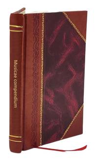
Renati Des Cartes
Musicae compendium 1656 Leather Bound
2017. Leather Bound. New. Size: 14.60 x 22.86 cms This book is available in 5 different Leather color without any extra cost. Explore More Options by Clicking on 'More Images' and Notify Us of Your Choice via Email within 24 hours of placing the order. Presenting an Exquisite Leather-Bound Edition expertly crafted by the prestigious organization “Rare Biblio” with Original Natural Leather that gracefully adorns the spine and corners. The allure continues with Golden Leaf Printing that adds a touch of elegance while Hand Embossing on the rounded spine lends an artistic flair. This masterpiece has been meticulously reprinted in 2017 utilizing the invaluable guidance of the original edition published many years ago in 1656. The contents of this book are presented in classic black and white. Its durability is ensured through a meticulous sewing binding technique enhancing its longevity. Imprinted on top-tier quality paper. A team of professionals has expertly processed each page delicately preserving its content without alteration. Due to the vintage nature of these books every page has been manually restored for legibility. However in certain instances occasional blurriness missing segments or faint black spots might persist. We sincerely hope for your understanding of the challenges we faced with these books. Recognizing their significance for readers seeking insight into our historical treasure we've diligently restored and reissued them. Our intention is to offer this valuable resource once again. We eagerly await your feedback hoping that you'll find it appealing and will generously share your thoughts and recommendations. Lang: - Latin Vol:- Pages:- 42 If it is a multi-volume set then it is only a single volume. Product Disclaimer: Kindly be informed that owing to the inherent nature of leather as a natural material minor discolorations or textural variations may be perceptible. Explore the FOLIO EDITION 12x19 Inches: Available Upon Request. hardcover
书商的参考编号 : BIBLB004040010
|
|
|
Renatus Des Cartes
De Homine Figuris et La Tinitate Donatus a Florentio Schuyl Inclytæ Urbis Sylvæ-Ducis Senatore & ibidem Philosophiæ Professore.
Title: De Homine Figuris et La Tinitate Donatus a Florentio Schuyl Inclytæ Urbis Sylvæ-Ducis Senatore & ibidem Philosophiæ Professore.<br />Author: Renatus Des-Cartes<br />Publisher: Ex Officina Hackiana<br />Place: Lugduni Batavorum Leiden<br />Publication date: 1664<br /><br />Description: 1664. Second edition only two years after the first appeared in the same city contemporary with the final definitive edition. Latin text. 38 121 Pp. 10 plates 2 folded and 1 with 2 movable overlays showing the interior regions of the heart. Profusely adorned with numerous splendid anatomical illustrations engraved in copper and wood many in half or full page. Woodcut title-page device; head and tailpieces. Small 4to. Full contemporary red morocco with gilt stamped title and design over spine and boards red marble endpapers. Provenance: Ex-Libris label of M. Gonzalez-Ulloa of Mexico book plate.<br /><br />Measures: 8.25 H x 6.5 D x 1 W inches.<br /><br />Notes: As is known Descartes labored on the work since 1630 but decided not to publish it privy to knowledge of Galileo's conviction in 1633. In acknowledgement of Harvey's important discovery Descartes did not believe that blood circulation was caused by heartbeats but considered the human body as a machine directed by a rational principle located in the pineal gland. Considered the first attempt to embrace all animal physiology the "De Homine ." is actually a kind of physiological supplement to the "Discours de la Methode" published in 1637 a source of inspiration for many scholars. "This book was the first attempt to cover the whole field of animal physiological appendix to his Discourse on method." Garrison-Morton. Work of fundamental importance among the most eminent products of human ingenuity. Good example Garrison-Morton 574. Wellcome Catalogue. II 453.<br /><br />See my listings for another Renati Des-cartes book titled Principia Philosophiæ. 1692. <br /><br />CONDITION NOTES: Very good; some minor binding edge wear at extremities ex-libris label pasted to inside front board. Stamped Bibliotheca Gonzaleana – Les Mariodes on front free endpaper with penciled notes at front and rear. Title page age-toned with margin losses at top and bottom right page edges/corner tips old repairs. Tight square spine text pages lightly age-toned and puckered overall text is clean with some foxing of top and side margin at leaf edge one folding plate with tears at crease 1.75 in. at bottom 1 in at top some micro tears at long leaf edge of rear plates. See example images. An attractive copy. Ex Officina Hackiana. hardcover
书商的参考编号 : 1295
|
|
 ?????????
 ?????PDF???
 RSS feed


