|
|
|
ROBERT de VAUGONDY (Didier).
Turquie asiatique.
1748. 162 x 195 mm.
Referenz des Buchhändlers : LBW02e6e
|
|
|
Rob Talbot; Robin Whiteman
The Yorkshire Moors and Dales (Country)
No marks or inscriptions. No creasing to covers or to spine. A very clean very tight copy with bright unmarked boards and no bumping to corners. 160pp. Some of England's finest examples of both natural and man-made scenery, photographed in colour by Rob Talbot and described from historical, geographical and natural perspectives by Robin Whiteman.

|
|
|
ROBBE, Jacques.
Méthode pour apprendre facilement la Géographie. Contenant un Abbrégé de la Sphère, la division de la Terre en ses Continens, Empires, Royaumes, États, Républiques, Provinces, &c. Avec les tables des villes les plus notables de chaque province. Tome Premier [sur deux].
À La Haye, chez Henri Van Bulderen, 1691. 8vo.; frontispicio grabado en cobre, 11 hojas, 575 pp., 8 hojas y 14 mapas plegados, dibujados por Nicholas de Fer (1646-1720) y grabados en cobre por De Winter. Encuadernación de época en piel, con lomera profusamente ornada. Este Tomo Primero contiene: Mapamundi, y los mapas de Europa, Francia, Imperio de Alemania, Países Bajos, Polonia, Rusia Blana, Suecia y Noruega, Dinamarca, Islas Británicas, España, Italia, Grecia (como la parte meridional de Turquía en Europa) y Hungría (como la parte septentrional de Turquía en Europa).

|
|
|
ROBERT ; [ VAUGONDY, Robert de ]
La Judée ou Terre Sainte divisée en ses douze Tribus. Par le Sr. Robert, Géographe du Roi, avec privilège, 1750 [Avec :] Carte de la Terre de Canaan ou Terre Promise à Abraham et à sa Postérité.
1 carte sous encadrement verre et bois au format 76 x 65 cm (format du cadre), le format apparent de la carte, sous marie-louise, est de 61 x 50,5 cm, frontières rehaussée en couleur, 1750 Bel état pour cette belle carte ancienne de Terre Sainte, déjà encadrée. A saisir. Français

|
|
|
ROBERT DE VAUGONDY, Didier
Archipel des Indes Orientales qui comprend les Isles de la Sonde, Moluques et Philippines, tirées des Cartes du Neptune Oriental
Carta geografica colorata a mano (53,5x71), con larghi margini, buone condizioni. Hand coloured map (53,5x71), large margins, good copy.
|
|
|
ROBERT DE VAUGONDY, Didier
Partie Orientale de l’Empire de la Russie en Asie...et le confins de la Tatarie Chinoise
Carta geografica colorata a mano (55x80), larghi margini, qualche macchia al margine inferiore. Geographic map, hand coloured, (55x80), some brownings at the lower margin.
|
|
|
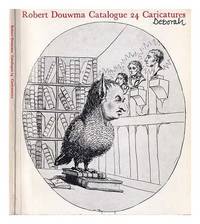
Robert Douwma (Prints & Maps) Ltd. Cumming, John
Robert Douwma catalogue 24 : caricatures / compiled by John Cumming
London : Robert Douwma Prints & Maps Ltd 1979. 1st edition. Softcover. Very good copy in the original stiff-card wrappers; edges slightly nicked and dust-dulled as with age. Remains particularly and surprisingly well-preserved; tight bright clean and especially sharp-cornered. Physical description; 76 pages : illustrations ; 22 cm. Notes; Cover title. Includes indexes. Includes bibliographical references page 76. Subjects; Robert Douwma Prints & Maps Ltd. ; Catalogs. Robert Douwma Prints & Maps Ltd. Prints English ; Catalogs. Caricatures and cartoons England ; Catalogs. Estampe anglaise ; Catalogues. Caricatures et dessins humoristiques ; Catalogues Angleterre. Caricatures and cartoons. Prints English. Caricatures and cartoons England ; Catalogs. England. London : Robert Douwma (Prints & Maps) Ltd paperback
Referenz des Buchhändlers : 406136
|
|
|
Robert Fulford
Canada - A Celebration
Inscription opposite half-title page. No other marks. A very clean very tight copy with bright unmarked boards and no bumping to corners. Dust jacket price clipped but not marked or torn with crease to front dust flap. 240pp. The book follows the route of a traveller crossing Canada from East to West, exploring each of the provinces and territories in his path. It is a spectacular depiction of the land of Canada, its history and a verbal tribute to the country's people.

|
|
|
Robert Gambee
Nantucket Island (Signed By Author)
New book still in shrink wrap. Presumably signed before sealing. pp. A photographic album of Nantucket Island off Cape Cod, Massachusetts.

|
|
|
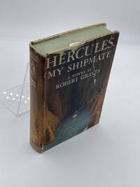
Robert Graves And Maps On End Papers
Hercules My Shipmate
Creative Age Press. Good in Good dust jacket. 1945. First Edition. Hardcover. Dust cover has noticeable tears. Yellowing to pages. Spill stain to edge of pages. - Good overall condition. General wear. No major blemishes. No writing. ; - We're committed to your satisfaction. We offer free returns and respond promptly to all inquiries. Your item will be carefully wrapped in bubble wrap and securely boxed. All orders ship on the same or next business day. Buy with confidence. . Creative Age Press hardcover
Referenz des Buchhändlers : HVD-23715-A-0
|
|
|
Robert, Gilles:
Partie septentrionale du Comte de Bourgogne ou Franche-Comte, ou sont les Bailliages de Vesoul, Gray, Besancon, Baume, le comte de Montbelliard, et parie des Bailliages de dole, Quingey et Ornans. Grenzkolorierter Kupferstich aus dem Atlas Universel von Robert und Vaugondy
Format (Darstellung): 46,5 x 56 cm. Blatt: 52 x 80 cm. Landkarten de
|
|
|
Roberts, Brian K.
Making of the English Village, The: A Study in Historical Geography
Book is in excellent condition. Binding is solid and square, covers have sharp corners, exterior shows no blemishes, text/interior is clean and free of marking of any kind. Contents include: Anatomy of the village, Row plans, Archaeology of villages, Composite village plans, Dominants and details, with a great many maps of all kinds. Book "shows how (Village) plans can be dissected, analysed and dated, demonstrates the presence of important regional contrasts, examines the processes creating, altering and destroying plays through time..." Copyright 2011 Pistil Books
|
|
|
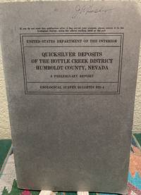
Roberts, Ralph J. & Maps
Quicksilver Deposits of the Bottle Creek District Humboldt County Nevada A Preliminary Report
Washington D. C.: Government Printing Office 1940. First Edition. Softcover. Good. Unmarked. USGS library pocket in back cover. ; Book Description; Spine has no signs of creasing. Pages are clean and not marred by notes or folds. Covers are square with minor wear. Ships Safe and Fast. ; Geological Survey Bulletin; Textbook; Vol. 922A; B&W Illustrations; 8vo 8" - 9" tall; 28 pages DC6. Government Printing Office unknown
Referenz des Buchhändlers : 19073
|
|
|
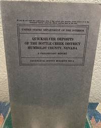
Roberts, Ralph J. & Maps
Quicksilver Deposits of the Bottle Creek District Humboldt County Nevada Strategic Minerals Investigations
Washington D. C.: Government Printing Office 1940. First Edition. Softcover. Very Good. Unmarked. ; Book Description; Spine has staples. Pages are clean and not marred by notes or folds. Covers are square with wear as noted. Ships Safe and Fast. fold outs in text; Geological Survey Bulletin; Textbook; Vol. 922A; 8vo 8" - 9" tall; 29 pages DC6. Government Printing Office unknown
Referenz des Buchhändlers : 19072
|
|
|
Roberts, Tony & Elizabeth
See the Lleyn Peninsula
No marks or inscriptions. No creasing to covers or to spine. A very clean very tight copy with bright unmarked boards and no bumping to corners. 64pp.

|
|
|
ROBERTSON, William
Histoire de l’Amerique
Tre voll., in -8°, pp. XXXI, 487; 539; 513; pelle con fregi, tasselli e titoli al dorso. Completo delle cinque tavole ripiegate, di quattro carte e una tavola, “Table chronologique des Mexicains”. Complete of five folding plates, four geographic maps and a non folding plate: “Table chronologique des Mexicains”.
|
|
|
Robinson, W. W., Illustrated With Maps, And Drawings By Irene Robinson
A Group Of 30 Individual Softcover Books On The History Of Southern California Localities Each Different Including 21 First Editions Written By W. W. Robinson. For Title Guaranty And Trust Beverly Hills Culver City Glendale Inglewood Land Titles In Long Beach Monrovia Pasadena Pomona San Fernando Valley San Pedro And Wilmington Santa Monica Whittier Santa Catalina The Forest And The People: The Story Of The Angeles National Forest Kern County Old Spanish & Mexican Ranchos Of Orange County 1958 Reprint The Story Of Riverside County The Story Of San Bernardino County The Story Of San Luis Obispo County The Story Of Tulare County And Visalia Ventura County
Los Angeles California: Title Guarantee And Trust / Title Insurance And Trust 1935 1936 1937 1938 1942 1946 1949 1951 1956 1957 1959 1961 1935. First Edition 1st Printing. Soft cover. Very Good/No Dust Jacket. 9 1/4" High. A Group Of 30 Different Booklets Including 19 Different First Printings 1935-1961 One With Second Issue Tipped In Slip 8Th Printing Of Old Spanish And Mexican Ranchos Of Orange County Six Are First Printings Of Later Revisions There Were Many Minor Revisions Usually Each Time They Were Re-Issued. Several Have Notations On Covers That They Were Gifts To Dr. George Hill Hastings From Arthur Mordan President Of Title Guaranty Who Employed Robinson. The Beverly Hills Book Has A Presentation Inscription From Mordan To Hastings The Island Of Santa Catalina Has A Long Notation By Hastings That It Was A Gift From Robinson Upon The Death Of Mordan A Dear Friend; Signed H. H. All Very Good To Near Fine Except Culver City Which Has Wear And Some Damp Spotting Centered On Spine And Extending Inwards Up To 1/4"; And The Forest And The People Is Only Good Worn And Some Small Light Water Spots. <br/> <br/> Title Guarantee And Trust / Title Insurance And Trust 1935 1936 1937 1938 1942 1946 1949 1951 1956 1957 1959 1961 paperback
Referenz des Buchhändlers : 036820
|
|
|
ROBINSON, NANCY with illustrations by FRANCIS, JILL and maps by DOWLER, IAN
RELUCTANT HARBOUR - The Romance of Port Pirie
Nadjuri Jamestown SA 1976. 327 pp including index maps on end papers previous owner's name on front end-paper b&w photographic and line illustrations maps fine copy in illustrated laminated boards. Nadjuri, Jamestown SA, 1976 hardcover
Referenz des Buchhändlers : 230417
|
|
|
Robson, John
Captain Cook's World. Maps of the Life and Voyages of James Cook R.N.
New Zealand, Random House, 2000. 211 p. with 128 maps and a gazetteer. 30,5 x 25 cm, hardcover with original wrappers.
Referenz des Buchhändlers : 23956
|
|
|
ROCHE Aimé O. M. I:
Clartés Australes Joseph Gérard, O. M. I. Le "Prêtre bien-aimé des Basotho" (1831-1914) Préface de Son Em. Mgr. Feltin, Archevêque de Paris.
Lyon, Éditions du Chalet, 1951. In-8 de 396-[4] pages, pleine basane caramel, premier plat orné d'une composition figurant deux cases et de la végétation, dos lisse, couvertures conservées.
Referenz des Buchhändlers : 19753
|
|
|
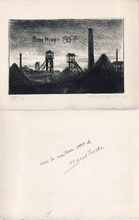
Roche, Marcel
Marcel Roche : carte de voeux pour 1957 et gravure originale
1957 Carte de voeux de Marcel Roche pour l'année 1957. 14,5 x 19 cm, 2 ff., en deuxième page une gravure en noir représentant un paysage minier, numérotée 58/75 et signée à la mine de plomb, en troisième page un envoi autographe signé à la plume.
Referenz des Buchhändlers : 1053
|
|
|
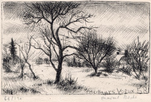
Roche, Marcel
Marcel Roche : carte de voeux pour 1958 et gravure originale
1958 Carte de voeux de Marcel Roche pour l'année 1958. 10 x 14,5 cm, 2 ff., en page 3 une gravure en noir, numérotée 66/120 et signée à la mine de plomb, le reste muet.
Referenz des Buchhändlers : 1476
|
|
|
Roche, Marcel
Marcel Roche : carte de voeux pour 1955 et gravure originale
1955 Carte de voeux de Marcel Roche pour l'année 1955. Carte de 12 x 15 cm, portant une gravure sur bois en noir enrichie d'un mot autographe signé de l'artiste.
Referenz des Buchhändlers : 1477
|
|
|
Rochford, Noel
Landscapes of Corfu
No marks or inscriptions. Crease to lower corner of front cover, none to spine. A very clean very tight copy with bright unmarked boards and no bumping to corners. Large pull-out map in excellent condition. 128pp. Walking tours in Corfu plus car trips and picnic places.

|
|
|
Rochford, Noel
Landscapes of Lanzarote
No marks or inscriptions. No creasing to covers or to spine. A very clean very tight copy with bright unmarked boards, slight fading near spine and no bumping to corners. Large pull-out map in excellent condition. 70pp. Walking tours in Lanzarote plus car trips and picnic places.

|
|
|
Rockwell, John A. (Maps by Charles Preuss)
THIRTIETH CONGRESS - SECOND SESSION : REPORT NO. 145 HOUSE OF REPRESENTATIVES. CANAL OR RAILROAD BETWEEN THE ATLANTIC AND PACIFIC OCEANS FEBRUARY 20 1849; includes PREUSS MAPS
Washington D.C.: Government Printing Office 1849. Hardcover. Very Good. Octavo 9.2 in. x 6 in. pp. 678 1 index. Personal copy with gilt ownership plate to front board of DeWitt C. Lawrence Chief Clerk of the Patent Office. Illustrated with sixteen folding maps. Black half calf with decorative gilt chain rule over marbled boards. Rebacked spine. Gilt name on black ownership panel to front board. Black title on paper panel to spine. Marbled endpapers. Front free endpaper detached but present. Detailed pencil notes presumably from DeWitt Lawrence to preliminary pages index and rear endpapers and to occasional penciled comments on margins of main text providing reference and guidance. Fremont Preuss's maps #II-VIII in VG condition. Other maps in G condition with additional creases a few short closed tears at seams and light browning to several edges. <br /> <br /> ALL16 maps detached as they were removed for preservation and study. Maps I IX-XVI folded in archival pocket. The PREUSS Maps II-VIII "The Rockwell Maps" are laying flat preserved in archival sheath and will be mailed separately under cover. Includes additional copy of Rockwell's map of "Section III". The 16 folded maps include: #I. Map of the Country Between the Atlantic and Pacific Oceans. 1848. Rob Mills. Pencil notes on map. #II-VIII. Road from Missouri to Oregon in 7 Sections 1848. Charles Preuss. Includes two identical copies of Section #III map. All eight Preuss maps in VG condition #IX. Republica Mexicana Plano del Curso del Rio Coatzacoalcos. 1843 #X. Profils en Long et en Traviors du Canal. L'Isthme de Panama1841. Garella. #XI. Profile of That Section of the Country between Nicaragua and the South Sea 1838. Based on Thompson's Guatamala. #XII. Nicaragua Realejo Harbour Edward Belcher Harbour of San Juan de Nicaragua George Peacock 1832 #XIII. Chart of the Bay of Limon or Navy Bay 1829. J.A. Lloyd. #XIV. Republica Mexicana Pano de la Parte Austral del Istmo de Tehuantepec 1843. Jose de Garay. #XV. Panama Canal Longitudinal Section. J.A. Lloyd. Four inch closed tear with 1/2 inch chip to seam. #XVI. Carte Topographique de la Partie De L'Isthme de Panama comprise entre Panama Chagres. 1845. Garella. Uniquely annotated copy. <br /> <br /> The "first major government report devoted to interoceanic communication.Rockwell in addition to his prime focus on Central American canals compiled memorable documents on the suddenly urgent need for more directly binding California to the Union.Foremost.was the matchless seven-section map of the Oregon Trail made by Charles Preuss Fremont's gifted cartographer. Lieut. G.K. Warren in his 1859 memoir wrote that Preuss's 'skill in sketching topography in the field and in representing it on the map has probably never been surpassed in this country.' <br /> <br /> ".The Senate had issued this map separately in 1846; now the House was trying to make available to the Forty-0niners what was by far the best trail map of them all.this treasure was so deeply buried in this report that but few gold seekers found it and it is still so rare in both editions that Wheat lamented that it ' has been insufficiently appreciated by students of Western history.' ." Plains & Rockies 1800-1865: Supplemental volume to the series News of the Plains and Rockies; 2001 Arthur H. Clark Spokane. [Government Printing Office] hardcover
Referenz des Buchhändlers : 87523
|
|
|
Rocque John
A Plan of Rome… / La Topographia di Roma da G. B. Nolli… / Plan de Rome...
Pianta di Roma a proiezione verticale, orientata con il nord in alto.Incisa da R. Benning per il cartografo inglese John Rocque e basata sulla pianta di Giovan Battista Nolli del 1748."Come annunciato nel titolo (ripetuto anche in italiano e francese), si tratta di una diretta derivazione della pianta piccola del Nolli che l'autore ha voluto riportare nella scala in cui aveva già pubblicato la pianta della città di Londra. In basso a sinistra indice delle fabriche più ragguardevoli contenute nella pianta con 170 voci suddivise in sei colonne. In basso a destra dedica a Sir. Bouchier Wrey. Le emergenze architettoniche sono campite in nero ed il resto degli isolati a tratteggio diagonale. In basso a sinistra il nome dell'incisore R. Benning sc. La stessa pianta fu rstampata nel 1773 dal Sawyer" (cfr. Marigliani p. 274).Acquaforte, finemente colorata a mano, in buono stato di conservazione. Non comune. Vertical projection map of Rome, oriented with the north at the top.Published in 1750 by John Roque, from the earlier plan by Goivanni Battista Noli published in 1748 (These dates are printed on the map).As announced in the title (also repeated in Italian and French), this is a direct derivation of the small map of Nolli that the author wanted to bring back to the scale in which he had already published the map of the city of London. At the bottom left index of the most remarkable fabrications contained in the plan with 170 entries divided into six columns. Bottom right dedication to Sir. Bouchier Wrey. The architectural buildings are in black and the rest of the blocks are in diagonal hatching. Bottom left the name of the engraver R. Benning sc. The same plan was printed in 1773 by Sawyer (see Marigliani p. 274).Etching, finely colored by hand, in good condition. Not common. C. Marigliani, "Le Piante di Roma delle collezioni private", n. 192; Scaccia Scarafoni, "Le Piante di Roma", n. 230.

|
|
|
Roddy, H. J.
PHYSICAL & INDUSTRIAL GEOGRAPHY OF LANCASTER COUNTY, PENNSYLVANIA.
115 p. + Half tone photographic illustrations; + Folding Maps. Tall 8vo. Original cloth backed printed paper boards. Binding worn and slightly soiled. Scarce. PA 24 x2
|
|
|
Roderick MacFarquhar
The Forbidden City
No marks or inscriptions. A very clean very tight copy with bright unmarked boards and no bumping to corners. Dust jacket not price clipped or marked or torn or creased with very minor traces of storage. 172pp. With nearly 150 illustrations, many in colour, this account describes China's Forbidden City which only became accessible to all Chinese citizens after the 1911 revolution.

|
|
|
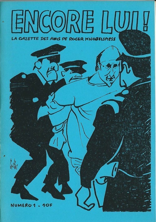
Roger Knobelspiess - Georges Blondeaux, dit Gébé - Jimmy Gladiator.
Encore Lui ! - La Gazette des amis de Roger Knobelspiess, n° 1. ( Dédicace autographe de Jimmy Gladiator sur carte postale )
Revue Encore lui ! La Gazette des amis de Roger Knobelspiess n° 1 de 1987. Plaquette in-8, agrafée, de 26 pages au format 15 x 21 cm. Couvertures illustrées par Gébé et Willem. Double page illustrée par Gébé. Directeur de la publication, Marie Rivière. Directeur empêché, Roger Knobelsiess. Rédacteur en chef Jimmy Gladiator. Textes de Roger Knobelsiess, Louis-Jean Calvet, Serge Quadruppani, Jimmy Gladiator, etc. Petit tirage. Edition originale enrichie d'une superbe dédicace autographe, signée, à Annie Gérardin, au verso d'une carte postale expédiée par Jimmy Gladiator de Grèce. Etat proche du neuf.
Referenz des Buchhändlers : 6305
|
|
|
Roger TREZEL
La clé du bridge
Fayard, Paris, 1969. Un volume in 8° broché de 168 pages. Bon état.
Referenz des Buchhändlers : 1038
|
|
|
Rogers, A.C. (Fred) (Signed)
Hiking - Mountain Biking & Adventure Trails of the Nanaimo-Extension Mines, Alberni Valley and Other Vancouver Island East Districts
78 pages. Documents over 40 hiking trails in the mid-island area. A wonderful reference including detailed descriptions and maps. Former owner's notes on back page. Moderate wear and light soiling. Author's signature upon title page. Book
|
|
|
ROGISSART Alexandre de
Rome
Veduta tratta dal "Les delices de l'Italie, contenant une description exacte du Païs, des principales villes, de toutesa les Antiquitez" edito, per la prima volta, a Leida nel 1706 da Pieter Vander Aa e successivamente ristampato a Parigi da Guillaume Cavelier.La maggior parte delle copie della seconda edizione reca nel frontespizio l'indicazione Compagnie des libraires, associazione di librai stampatori la cui composizione è variata negli anni ma di cui Guillaume Cavelier faceva parte.La guida, che sappiamo da Barbier I, 872 essere opera di Rogissart e dell'abate Havard, è impreziosita da 152 tavole,Incisione in rame, in buono stato di conservazione. Bibliografia Marigliani (2007): p. 259, n. 169. Panorama of Rome taken from "Les delices de l'Italie, contenant une description exacte du Païs, des principales villes, de toutesa les Antiquitez"published for the first time in Leiden in 1706 by Pieter Vander Aa and later reprinted in Paris by Guillaume Cavelier. Most of the copies of the second edition have on the title page the indication Compagnie des libraires, an association of booksellers and printers whose composition has varied over the years but to which Guillaume Cavelier belonged. The guide, which we know from Barbier I, 872 to be the work of Rogissart and Abbot Havard, is embellished with 152 plates Copper engraving, in good condition. Literature Marigliani (2007): p. 259, n. 169.

|
|
|
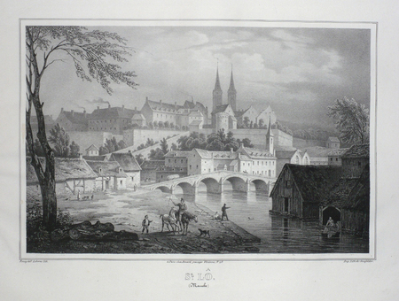
ROISSY;
ST. LO (Manche).
Paris Benard circa 1850 217 x 290 mm.
Referenz des Buchhändlers : LBW03d67
|
|
|
Rollin
Atlas de géographie ancienne pour servir à l'intelligence des oeuvres de Rollin, gravé d'après les cartes originales de d'Anville
complet de ses 27 cartes et plans, gravés par Ambroise Tardieu Histoire ancienne; monde connu des anciens, Égypte et Libye, partie de l'Afrique ou les Carthaginois ont étendus leurs dominations, carte pour l'expédition d'Annibal et son passage en Italie, carte pour l'intelligence de l'histoire des Assyriens, des Babyloniens et des Perses, Grèce, grande Grèce & Sicile, Plan de Syracuse, carte pour l'expédition de Syrus et la retraite des dix mille Grecs, Grèce et pays septentrionaux jusqu'au Danube, Expédition d'Alexandre, Orient, Asie mineure. Histoire Romaine; environ de Rome, Rome ancienne, Italie, Italie ou l'on a tracé les voies Romaines, vue du combat naval d'Ecnome, expédition d'Annibal, Sicile, plan de Syracuse, Espagne, Grèce, Gaule cisalpine, Numidie, Province Romaine dans la Gaule, Gaule au temps de la conquête de César. vol in8, demi cuir 18x10, bel état de l'ensemble, cartes dépliées, de dimentions variables soit 43x39cm, 40x33cm, etc.. Paris, chez Carez, Thomine & Portic, 1819 ref/155
Referenz des Buchhändlers : CZC-11870

|
|
|
Rollin
Atlas de géographie ancienne pour servir à l'intelligence des oeuvres de Rollin, gravé d'après les cartes originales de d'Anville
complet de ses 27 cartes et plans, gravés par Ambroise Tardieu Histoire ancienne; monde connu des anciens, Égypte et Libye, partie de l'Afrique ou les Carthaginois ont étendus leurs dominations, carte pour l'expédition d'Annibal et son passage en Italie, carte pour l'intelligence de l'histoire des Assyriens, des Babyloniens et des Perses, Grèce, grande Grèce & Sicile, Plan de Syracuse, carte pour l'expédition de Syrus et la retraite des dix mille Grecs, Grèce et pays septentrionaux jusqu'au Danube, Expédition d'Alexandre, Orient, Asie mineure. Histoire Romaine; environ de Rome, Rome ancienne, Italie, Italie ou l'on a tracé les voies Romaines, vue du combat naval d'Ecnome, expédition d'Annibal, Sicile, plan de Syracuse, Espagne, Grèce, Gaule cisalpine, Numidie, Province Romaine dans la Gaule, Gaule au temps de la conquête de César. vol in8, demi cuir 18x10, bel état de l'ensemble, cartes dépliées, de dimentions variables soit 43x39cm, 40x33cm, etc.. Paris, chez Carez, Thomine & Portic, 1819 ref/155
Referenz des Buchhändlers : CZC-11870
|
|
|
Rollin
Atlas de l'histoire ancienne de Rollin. 60 planches et 10 cartes anciennes
Architecture, sacré, architecture militaire, architecture civile, sépulture, royale, armes et meubles, navigation du Nil, costume religieux et civile, costume militaire, travaux agricoles, art. Plan de Carthage, tombeau, Agrigente détruit par les Cartaginois, amphithéâtre de Tyrus, guerrier, perce, ruine de Babylone, ruine de Persépolis, peinture babylonienne, écriture, décale des un et des perce temple et Hôtel, du feu, tombeau Perse, tombeau de Cyrus, plan d’Athènes, ionique, temple de thèse à Athènes Propylées d’Athènes, tombeau grec, vue de Pirée et de l’acropole d’Athènes, costume grecques, Jupiter Olympia, Camp romain. Tombeaux militaires - planches de costumes - sépultures royales - Perses & assyriens - ruines de Persépolis - plan d’Athènes, thermes ou bains de Caracalla, Pont du Gard, Maisons Romaines...etc table explicative et descriptif des planches Cartes présentes : L’Égypte et la Cyrenaique, par Vivien 1836 - Pays de Carthage, par Vivien 1836 - Asie ancienne, par Vivien 1837 - Asie mineures et Syrie par Dufour 1838 - Grèce ancienne parDufour 1838 - Grèce septentrionale par Dufour - Italie par Dufour 1838 - La Gaule au temps de César, par Dufour 1839 - l'Empire Romain par Dufour 1839 - Empire Romain, partie Orientale par Dufour 1839 Volume relié in-4, 270x180, demi cuir, accrocs ,traces d'humidité ancienne, rousseur, complet des gravures & cartes, sans date vers 1840/1860.
Referenz des Buchhändlers : CZC-13111

|
|
|
Rollin
Atlas de l'histoire ancienne de Rollin. 60 planches et 10 cartes anciennes
Architecture, sacré, architecture militaire, architecture civile, sépulture, royale, armes et meubles, navigation du Nil, costume religieux et civile, costume militaire, travaux agricoles, art. Plan de Carthage, tombeau, Agrigente détruit par les Cartaginois, amphithéâtre de Tyrus, guerrier, perce, ruine de Babylone, ruine de Persépolis, peinture babylonienne, écriture, décale des un et des perce temple et Hôtel, du feu, tombeau Perse, tombeau de Cyrus, plan d’Athènes, ionique, temple de thèse à Athènes Propylées d’Athènes, tombeau grec, vue de Pirée et de l’acropole d’Athènes, costume grecques, Jupiter Olympia, Camp romain. Tombeaux militaires - planches de costumes - sépultures royales - Perses & assyriens - ruines de Persépolis - plan d’Athènes, thermes ou bains de Caracalla, Pont du Gard, Maisons Romaines...etc table explicative et descriptif des planches Cartes présentes : L’Égypte et la Cyrenaique, par Vivien 1836 - Pays de Carthage, par Vivien 1836 - Asie ancienne, par Vivien 1837 - Asie mineures et Syrie par Dufour 1838 - Grèce ancienne parDufour 1838 - Grèce septentrionale par Dufour - Italie par Dufour 1838 - La Gaule au temps de César, par Dufour 1839 - l'Empire Romain par Dufour 1839 - Empire Romain, partie Orientale par Dufour 1839 Volume relié in-4, 270x180, demi cuir, accrocs ,traces d'humidité ancienne, rousseur, complet des gravures & cartes, sans date vers 1840/1860.
Referenz des Buchhändlers : CZC-13111
|
|
|
Roland ROSSI
COURS de CARTOMANCIE
Un ouvrage de 154 pages, format 140 x 205 mm, illustré, broché couverture couleurs, publié en 1998, Editions de Vecchi, bon état
Referenz des Buchhändlers : LFA-126713427
|
|
|
ROLLIN et CREVIER
HISTOIRE ROMAINE DEPUIS LA FONDATION DE ROME JUSQU'A LA BATAILLE D'ACTIUM : C'est à dire jusqu'à la fin de la république
à Paris chez la veuve Etienne - 1752 8 volumes de format in-4 : 20 x 25,5 cm reliures plein veau marbré. Dos à 5 nerfs, caissons richement ornés à motifs dorés. Pièces de titre en maroquin rouge. Filets dorés sur les coupes. Tranches rouges, gardes marbrées, ex-libris de J.B Valentin. Tome 1 : éloge de M. Rollin, préface et avant propos 112 pages + 556 pages, 1 carte et un plan de Rome dépliants. Tome 2 : 56 pages + 600 pages, 2 cartes et 1 planche (plan du combat naval d'Ecnome)dépliantes. Tome 3 : 750 pages et 3 cartes et un plan dépliants. Tome 4 : 652 pages et 2 cartes dépliantes. Tome 5 : 672 pages. Tome 6 : 685 pages. Tome 7 : 684 pages, 1 carte dépliante. Tome 8 : 730 pages. Edition originale ,ornée de 10 cartes dépliantes et 2 plans dépliants.quelques coiffes abîmées (une est arrasée), traces de frottements sans conséquence (voir photos) rares rousseurs,quelques feuillets légèrement brunis,tous les cahiers sont bien alignés, mors solides peu usés.Bel exemplaire en reliure d'époque en bon état.
Referenz des Buchhändlers : 112

|
|
|
ROLAND (François)
Les Cartes anciennes de la Franche-Comté. Etude historique et descriptive
Besançon, Dodivers, 1913-1924 3 parties en 3 vol. in-8, XV-150 pp., 94 pp. et 166 pp., 37 planches, broché. Petit manque au dos de la troisième partie.
Referenz des Buchhändlers : 216147
|
|
|
Rolfe, William J.; Crockett, William D.
A SATCHEL GUIDE TO EUROPE. THE FORTY-EIGHTH ANNUAL EDITION. WITH MAPS.
pp. cvi, 596, (32)[Advertisements] + numerous large folding maps. Endpapers advertising Thos. Cook & Sons Travel Organization. Inked ownership of Helen M. Hafer, Hanover, PA. Paris bookseller's label. 12mo. Original full red cloth binding, lettered in gold. Original dust jacket, chipped with small loss. Hardbound. Nice copy. TOURISM; CLOTHING; VOYAGE; PASSPORTS; CYCLING; AIR LINES; RAILWAYS; FOLDING MAPS; HAFER; HANOVER TRAVEL/1
|
|
|
Rolfe, William J.; Crockett, William D.
A SATCHEL GUIDE TO EUROPE. THE FORTY-NINTH ANNUAL EDITION. WITH MAPS.
pp. cvi, 596, (24)[Advertisements] + numerous large folding maps. Endpapers advertising Thos. Cook & Sons Travel Organization. Discrete stamped ownership of Mrs. Alvin F. Fix, York, Pa. on title page and elsewhere. Mr. Fix was a PA Democrat. Delegate to Democratic National Convention from Pennsylvania, 1936. 12mo. Original full red cloth binding. Hardbound. Nice copy. TRAVEL/1
|
|
|
ROLMEDON, M.
Les Tours de Cartes les plus recreatifs et les plus surprenants.
in-12, 94 pp., figures, broche, couv. ill. Bel exemplaire, en grande partie non coupé. [CA26/4]
|
|
|
Rolt, L. T. C.; Drawings and maps by Kenneth Lindley
THE RAILWAY REVOLUTION: George and Robert Stephenson
New York: St. Martin's Press 1962. First American edition. Cloth. Very Good/Good. Kenneth Lindley. 8vo - over 7¾ - 9¾" tall. 1st American edition. A Very Good copy in Good dust jacket. 8vo. xviii i 356 pp. illustrated with charts and b&w photographs. Black cloth with train design on the front board in gilt; photo-illustrated black dust jacket. The dj is rubbed lightly soiled and has a small closed tear at the tip of the rear panel. The dj is now protected in a mylar sleeve. A Very Good copy in Good dj. St. Martin's Press unknown
Referenz des Buchhändlers : 003674

|
|
|
ROMANO Pasqual
Tours de magie amusants.
Chantecler, 2002. 14 x 23, 115 pp., très nombreuses figures, cartonnage d'édition imprimé, très bon état.
Referenz des Buchhändlers : 36714
|
|
|
RONCEREL (Michel).
Carte de voeux illustrée d'une gravure originale signée.
Paris Société des peintres-graveurs français 2002 1 vol. Broché Carte de voeux dépliante sur Arches illustrée d'une manière noire (21 x 15 cm) signée par Michel Roncerel. En parfait état.
Referenz des Buchhändlers : 109100
|
|
|
Ron Thornton
The River Tyne from Sea to Source
No marks or inscriptions. A very clean very tight copy with bright unmarked laminated boards, slight foxing to top of page edges and no bumping to corners. Dust jacket not price clipped or marked or torn with minor creasing to upper and lower edges. 160pp. A historical and background study of the River Tyne accompanied by the author's attractive paintings and illustrations. The direction of travel is from the harbour at Tynemouth upstream to both North and South Tyne sources. Beautifully illustrated.

|
|
|
Roomen Adrian van (Lovanio 1561 – Magonza 1615)
Roma
Pianta archeologica della città basata sul modello di Pirro Ligorio, pubblicata nel raro Parvum theatrum urbium sive urbium praecipuarum totius orbis brevis et methodica descriptio. Urbium praecipuarum totius orbis brevis et methodica descriptio [...]. di Adrian van Roomen, edita a Francoforte, Nicolaus Basse, 1595. Il Theatrum Urbium, stampato per la prima volta nel 1595 e quindi nel 1608, contiene 67 vedute silografiche di città. “Contains descriptions of Florida, New-France, New-Spain, Nova Galicia, Yucatan, Cuba, Brazil, Peru, etc." Also with views of Constantinople, Jerusalem, Genoa, London, Rostock, Rome, Vienna, Prague, Riga, Zurich, Genf, Bremen, Dresden, Geneva, Lubeck, Cologne, Leipzig, Mainz, Marburg, Munich, Nuremberg, Strasbourg, Trier, Ulm, Venice, Wittenberg and many others. (Sabin). Rara. Bibliografia Caldana, Roma Antica, Piante topografiche e vedute generali, p. 80, scheda I.11.Adams R 694. Bachmann 14. Muller 1376. Sabin 73000. Alden 595. Archaeological map of Rome based on the model of Pirro Ligorio (1561), published in the rare Parvum theatrum urbium sive urbium praecipuarum totius orbis brevis et methodica descriptio. Urbium praecipuarum totius orbis brevis et methodica descriptio [...]. by Adrian van Roomen, published in Frankfurt, Nicolaus Basse, 1595. The Theatrum Urbium, first printed in 1595 and again in 1608, contains 67 silographic views of cities. "Contains descriptions of Florida, New-France, New-Spain, Nova Galicia, Yucatan, Cuba, Brazil, Peru, etc." Also with views of Constantinople, Jerusalem, Genoa, London, Rostock, Rome, Vienna, Prague, Riga, Zurich, Genf, Bremen, Dresden, Geneva, Lubeck, Cologne, Leipzig, Mainz, Marburg, Munich, Nuremberg, Strasbourg, Trier, Ulm, Venice, Wittenberg and many others. (Sabin). Rare. Bibliography Caldana, Roma Antica, Piante topografiche e vedute generali, p. 80, scheda I.11.Adams R 694. Bachmann 14. Muller 1376. Sabin 73000. Alden 595.

|
|
|
 Per e-mail erhalten
 Als pdf-Dokument herunterladen
 RSS feed


