|
Thomas Bros Maps
Thomas Guide 2004 San Diego Including Portions of Imperial County: Street Guide San Diego County Including Portions of Imperial County Street Guide and Directory
acceptable. BOOK ONLY NO DISK spiral bound paperback cover and corner wear name on cover cover edge is taped creased covers paperback
书商的参考编号 : B61102BxxxN14388
|
|
|
Thomas Bros Maps
Western Maryland and Eastern Panhandle of West Virginia: Including: Garrett Allegany and Washington Counties in Maryland and Morgan Berkeley and Jef Thomas Guides Maps
Thomas Brothers Maps. Used - Good. Good condition. Updated edition. A copy that has been read but remains intact. May contain markings such as bookplates stamps limited notes and highlighting or a few light stains. Thomas Brothers Maps unknown
书商的参考编号 : NC01D-00828 ???????? : 1581743289 9781581743289
|
|
|
Thomas Brothers Maps
Western Maryland and Eastern Panhandle of West Virginia: Including: Garrett Allegany and Washington Counties in Maryland and Morgan Berkeley and Jef Thomas Guides Maps
spiral_bound. Good. Access codes and supplements are not guaranteed with used items. May be an ex-library book. unknown
书商的参考编号 : 1581743289.G ???????? : 1581743289 9781581743289
|
|
|
Thomas Brothers Maps
Zip Code San Bernardino and Riverside Counties Street Guide and Directory 1993
Thomas Brothers Maps 1992-08T. unbound. Good. . Spiral-bound. Cover shows minor wear pages are clean. Thomas Brothers Maps unknown
书商的参考编号 : mon0003104728 ???????? : 0881305685 9780881305685
|
|
|
Thomas Bros. Maps
Marin County street guide and directory
Ring binding with stiff laminated paper wraps. 1 atlas (1 volume (various pagings)) : color maps ; 21 x 24 cm. Maps. Marin County (Calif.) -- Maps. California -- Marin County. Scale [1:15,840]. 1 in. to 1/4 mile. || Cover title: "The Thomas Guide."/ Table of contents page title: Marin County, the Thomas Guide./ Includes indexes and "northern California fold-out map."/ "TBM 3025."
|
|
|
Thomas DipPubPol PhD MAPS, Shane A.
How to Write Health Sciences Papers Dissertations and Theses 1e
Churchill Livingstone. annotated edition. Paperback. Used; Very Good. Simply Brit welcome to our online used book store where affordability meets great quality. Dive into a world of captivating reads without breaking the bank. We take pride in offering a wide selection of used books from classics to hidden gems ensuring theres something for every literary palate. All orders are shipped within 24 hours and our lightning fast-delivery within 48 hours coupled with our prompt customer service ensures a smooth journey from ordering to delivery. Discover the joy of reading with us your trusted source for affordable books that do not compromise on quality. 05/04/2000 Churchill Livingstone paperback
书商的参考编号 : 3722086 ???????? : 0443062838 9780443062834
|
|
|
Thomas DipPubPol PhD MAPS, Shane A
How to Write Health Sciences Papers Dissertations and Theses
Churchill Livingstone 2000-06-20. Paperback. Very Good. Paperback. Pages are clean and unmarked. Covers show very minor shelving wear a slight bend in the book.; 100% Satisfaction Guaranteed! Ships same or next business day! Churchill Livingstone paperback
书商的参考编号 : 142203250041 ???????? : 0443062838 9780443062834
|
|
|
Thomas DipPubPol PhD MAPS, Shane A
How to Write Health Sciences Papers Dissertations and Theses
Churchill Livingstone 2000-06-20. Paperback. New. New. In shrink wrap. Looks like an interesting title! Churchill Livingstone paperback
书商的参考编号 : Q-0443062838 ???????? : 0443062838 9780443062834
|
|
|
Thomas DipPubPol PhD MAPS, Shane A
How to Write Health Sciences Papers Dissertations and Theses
Churchill Livingstone 2000-06-20. 1. paperback. New. 5.50x0.25x8.50. Buy with confidence. Excellent Customer Service & Return policy. Churchill Livingstone paperback
书商的参考编号 : DADAX0443062838 ???????? : 0443062838 9780443062834
|
|
|
Thomas DipPubPol PhD MAPS, Shane A
How to Write Health Sciences Papers Dissertations and Theses
Churchill Livingstone 2000-06-20. 1. paperback. Used: Good. 5.50x0.25x8.50. Buy with confidence. Excellent Customer Service & Return policy. Churchill Livingstone paperback
书商的参考编号 : SONG0443062838 ???????? : 0443062838 9780443062834
|
|
|
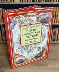
THOMAS MOULE'S COUNTY MAPS
The East & South-East of England : Moule's County Maps. With 19 full colour illustrations & maps : 15 County Maps & 4 Town Plans. Introduced by Ashley Baynton-Williams
Bracken Books London 1994. Hardcover. Good Condition/Good Condition. 48 pages with 19 colour maps & plans 22 x 29 cms each with text to the rear. Publisher's original red boards spine with gilt lettering and dustwrapper. All in good condition with mildly worn dustwrappers. The maps used in this edition appeared originally in Thomas Moule's English Counties Delineated 1830-36. The exquisite Victorian maps depicting England's counties and cities presented in a large format are the work of the esteemed British cartographer Thomas Moule. Thomas Moule is celebrated as one of the premier mapmakers of the Victorian era and is recognized as a true successor to John Speed in the annals of British cartography. His meticulously crafted maps of counties and cities serve as a detailed historical record of 19th-century England. Initially released in collectible segments from 1830 to 1837 these maps were later compiled into the comprehensive two-volume work titled The English Counties Delineated. Moule honored the antiquity and heritage of each county by incorporating pastoral and monument views within the maps all elegantly framed by cartouches festoons and architectural embellishments in various historical styles. The book£££s introduction outlines Moule£££s career as a writer and antiquarian situating his renowned maps within the context of the technical cartographic advancements of his time. It explores the diverse artistic and cultural influences reflected in Moule£££s work where he merges precise cartography with ornate architectural frames and evocative Romantic pastoral scenes of the England he cherished. However beneath this portrayal of antiquity lies the influence of the British Industrial Revolution. Moule£££s maps are significantly shaped by the pioneering efforts of the Ordnance Survey and document the relentless expansion of major cities and the rapid proliferation of railways. Size: 23.5 x 29.5 cms. Multiple copies available this title. Quantity Available: 3. Category: Varied Books; Featured Items; Hardback Books; ISBN: 185891194X. ISBN/EAN: 9781858911946. Inventory No: 373258. This item may require more postage than the rates shown for delivery outside the UK. If extra postage is required we will contact you before processing your order and you will be given the details and option to decline the extra cost. 9781858911946 Bracken Books hardcover
书商的参考编号 : 373258 ???????? : 185891194X 9781858911946
|
|
|
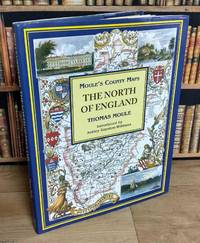
THOMAS MOULE'S COUNTY MAPS
The North of England : Moule's County Maps. With 19 full colour illustrations & maps : 12 County Maps & 7 Town Plans. Introduced by Ashley Baynton-Williams
Bracken Books London 1994. Hardcover. Good Condition/Good Condition. 48 pages with 19 colour maps & plans 22 x 29 cms each with text to the rear. Publisher's original blue boards spine with gilt lettering and dustwrapper. All in good condition with mildly worn dustwrappers. The maps used in this edition appeared originally in Thomas Moule's English Counties Delineated 1830-36. The exquisite Victorian maps depicting England's counties and cities presented in a large format are the work of the esteemed British cartographer Thomas Moule. Thomas Moule is celebrated as one of the premier mapmakers of the Victorian era and is recognized as a true successor to John Speed in the annals of British cartography. His meticulously crafted maps of counties and cities serve as a detailed historical record of 19th-century England. Initially released in collectible segments from 1830 to 1837 these maps were later compiled into the comprehensive two-volume work titled The English Counties Delineated. Moule honored the antiquity and heritage of each county by incorporating pastoral and monument views within the maps all elegantly framed by cartouches festoons and architectural embellishments in various historical styles. The book£££s introduction outlines Moule£££s career as a writer and antiquarian situating his renowned maps within the context of the technical cartographic advancements of his time. It explores the diverse artistic and cultural influences reflected in Moule£££s work where he merges precise cartography with ornate architectural frames and evocative Romantic pastoral scenes of the England he cherished. However beneath this portrayal of antiquity lies the influence of the British Industrial Revolution. Moule£££s maps are significantly shaped by the pioneering efforts of the Ordnance Survey and document the relentless expansion of major cities and the rapid proliferation of railways. Size: 23.5 x 29.5 cms. Multiple copies available this title. Quantity Available: 6. Category: Varied Books; Featured Items; Hardback Books; ISBN: 185891194X. ISBN/EAN: 9781858911946. Inventory No: 373256. This item may require more postage than the rates shown for delivery outside the UK. If extra postage is required we will contact you before processing your order and you will be given the details and option to decline the extra cost. 9781858911946 Bracken Books hardcover
书商的参考编号 : 373256 ???????? : 185891194X 9781858911946
|
|
|
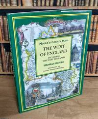
THOMAS MOULE'S COUNTY MAPS
The West of England : Moule's County Maps. Including the West Midlands. With 19 full colour illustrations & maps : 17 County Maps & 2 Town Plans. Introduced by Ashley Baynton-Williams
Bracken Books London 1994. Hardcover. Good Condition/Good Condition. 48 pages with 19 colour maps & plans 22 x 29 cms each with text to the rear. Publisher's original green boards spine with gilt lettering and dustwrapper. All in good condition with mildly worn dustwrappers. The maps used in this edition appeared originally in Thomas Moule's English Counties Delineated 1830-36. The exquisite Victorian maps depicting England's counties and cities presented in a large format are the work of the esteemed British cartographer Thomas Moule. Thomas Moule is celebrated as one of the premier mapmakers of the Victorian era and is recognized as a true successor to John Speed in the annals of British cartography. His meticulously crafted maps of counties and cities serve as a detailed historical record of 19th-century England. Initially released in collectible segments from 1830 to 1837 these maps were later compiled into the comprehensive two-volume work titled The English Counties Delineated. Moule honored the antiquity and heritage of each county by incorporating pastoral and monument views within the maps all elegantly framed by cartouches festoons and architectural embellishments in various historical styles. The book£££s introduction outlines Moule£££s career as a writer and antiquarian situating his renowned maps within the context of the technical cartographic advancements of his time. It explores the diverse artistic and cultural influences reflected in Moule£££s work where he merges precise cartography with ornate architectural frames and evocative Romantic pastoral scenes of the England he cherished. However beneath this portrayal of antiquity lies the influence of the British Industrial Revolution. Moule£££s maps are significantly shaped by the pioneering efforts of the Ordnance Survey and document the relentless expansion of major cities and the rapid proliferation of railways. Size: 23.5 x 29.5 cms. Multiple copies available this title. Quantity Available: 2. Category: Varied Books; Featured Items; Hardback Books; ISBN: 185891194X. ISBN/EAN: 9781858911946. Inventory No: 373257. This item may require more postage than the rates shown for delivery outside the UK. If extra postage is required we will contact you before processing your order and you will be given the details and option to decline the extra cost. 9781858911946 Bracken Books hardcover
书商的参考编号 : 373257 ???????? : 185891194X 9781858911946
|
|
|
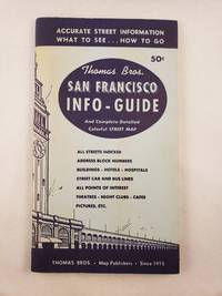
Thomas, Camille E. and Thomas Bros. Maps
Thomas Bros. San Francisco Info-Guide Showing All Streets Street car and bus transportations systems Hotels Buildings Amusements Points of Interest Etc.
San Francisco: Thomas Bros. Map Publishers 1957. 12mo.; illustrated stiff wraps with stapled binding softcover; 48 pages with fold-out map softcover; black and white photographic illustrations; wraps are sunned else very good. <br/><br/> San Francisco: Thomas Bros. Map Publishers, 1957 paperback
书商的参考编号 : 45497
|
|
|
Thomas, Emory M.; [maps by Jean Paul Tremblay]
Bold Dragoon: The Life of J. E. B. Stuart
Norman: University of Oklahoma Press. Fine. 1986 1999. First Edition Thus. Trade Paperback. 384 pages. Jeb Stuart leader of the cavalry of the Army of Northern Virginia earned the admiration of his enemies during the first three years of the Civil War. Famed for his daring ride around McClellan during the Peninsula Campaign and his raid behind Union lines in Virginia and into Maryland and Pennsylvania he was a legend long before he was killed at Yellow Tavern in 1864. . University of Oklahoma Press paperback
书商的参考编号 : 606706 ???????? : 0806131934 9780806131931

|
|
|
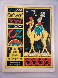
Thompson, Ruth Plumly, illustrated by Dick Martin and maps by James E. Haff
The Enchanted Island Of Oz
The International WIzard of Oz Club Inc. 1976. Small 4to.; illustrated stiff wraps softcover; 77 pages; black and white illustrations and maps; from the title page "founded on & continuing the famous OZ stories by L. Frank Baum"; a sunned errata slip laid in; bottom corner is bumped else very good. <br/><br/> The International WIzard of Oz Club, Inc., 1976 paperback
书商的参考编号 : 45456
|
|
|
Thompson, Courtney
Lighthouses of Atlantic Canada: A Pictorial Guide - New Brunswick, Nova Scotia, Prince Edward Island, Newfoundland & Labrador
128 pages. Index. Profusely illustrated with wonderful colour photos of lighthouses from each province, plus maps and directions, history, legend, lore and descriptions. Printed upon glossy stock. Clean and unmarked with moderate external wear. A quality copy of this charming and informative work. Book

|
|
|
Thompson, John M. T. / Stewart, Hugh B
Nonlinear Dynamics and Chaos.
New York, John Wiley & Sons, 1991. Geometrical methods for engineers and scientists XVI, 376 S. (24 cm) illustrierter Pappband / gebundene Ausgabe
书商的参考编号 : 55373 ???????? : 471909602
|
|
|
THORNE Noël
Lyon à la belle époque
Bruxelles, Editions Libro-Sciences, 1973. In-12, format à l'italenne. Cartonnage éditeur toie verte avec une llustration en noir et blanc contre-collée sur le 1er plat. 137 pages de reproductions NB de cartes postales anciennes légendées. Une petite tache sur la couverture sans gravité. Bon état de l'ensemble.
书商的参考编号 : 5248

|
|
|
Thornton Ian; B/W Photos; Maps on End Papers Illustrator
Darwin's Islands: A Natural History of the Galapagos
Natural History Press; American Museum of Natural History 1971-01-01. Hardcover. New. New. In shrink wrap. Looks like an interesting title! Natural History Press; American Museum of Natural History hardcover
书商的参考编号 : Q-0385074883 ???????? : 0385074883 9780385074889

|
|
|
Thorp, Willard L., Editor; Maps,
The United States and the Far East. Second Edition
Prentice-Hall Spectrum. Very Good in Very Good dust jacket. 1962. Paperback. 1.5 x 8.4 x 5.9 Inches. . Prentice-Hall Spectrum paperback
书商的参考编号 : 63057
|
|
|
Thorp, Willard L. , editor; Maps,
THE UNITED STATES and the FAR EAST. Second Edition.
Prentice-Hall Spectrum. Fair with no dust jacket. 1962. Paperback. Some underlining; 8.4 X 5.9 X 1.5 inches . Prentice-Hall Spectrum paperback
书商的参考编号 : 342952
|
|
|
THURA D.
Répertoire des cartes postales dessinées.
SEDLI/Jacky Goupil, 1984. In-8 broché, 110 pages, illustré de nombreuses vignettes dessinées. Bon état, peu courant.
书商的参考编号 : 14982
|
|
|
THYS Commandant
NIEUPORT 1914 1918
Les inondations de l’Yser et la compagnie des sapeurs pompiers du génie Belge. In 4 demi cuir fauve raciné à nerfs, faux-titre, titre, portrait de Léopold CALBERG tué à l’écluse de l’Yser le 16 juillet 1917. XX-148 pages, 551 figures (photos) et plans, certains dépliants, table des gravures III tables des photographies et des croquis supplémentaires relatifs aux chapitres I à XII (photos 138 à 551) 1pgae lexique de la terminologie locale, errata, 2 table des matières. Grande carte dépliante des inondations de l’Yser et Wateringue du nord de Furnes. Paris Berger-Levrault-Liège, Henri Desoer- Londres, Constable & Cie 1922. L’ensemble sur papier couché, non rogné. Edition originale. Bon exemplaire, peu courant
书商的参考编号 : 10768

|
|
|
Tiffou Jacky
Commenter la carte topographique aux examens et concours
Armand Colin Dos carré collé 2001 In-8 (16 x 24 cm), dos carré collé, 187 pages, figures en noir et blanc ; légères pliures d'usage au premier plat, bande brunie le long du mors inférieur au quatrième plat, par ailleurs bon état général. Livraison a domicile (La Poste) ou en Mondial Relay sur simple demande.
书商的参考编号 : lr626
|
|
|
TILLEY, Roger
Cartes à jouer et Tarots
1969 Editions Hachette, collection " Plaisir des images". 1939. 1 vol in-8 format carré, cartonnage éditeur illustré. 120 pages. Illustrations en noir et blanc et en couleur en et hors texte
书商的参考编号 : 99061
|
|
|
Tilmont
Atlas Classique
Wesmael Charlier Claire Rigide Illustrée Namur 1971 grand livre format A3
书商的参考编号 : 057124
|
|
|
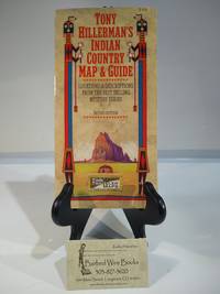
Time Traveler Maps
Tony Hillerman's Indian Country Map & Guide
Time Traveler Maps 2002. Map. Used- Near Fine. Map is clean and folds neatly into cover. Outside cover shows very light wear map inside is fine condition with very mild signs of use. No further markings on the inside of the book. Photos are of the book we have here at Barbed Wire Books. Time Traveler Maps
书商的参考编号 : BWBJ0141 ???????? : 1892040107 9781892040107
|
|
|
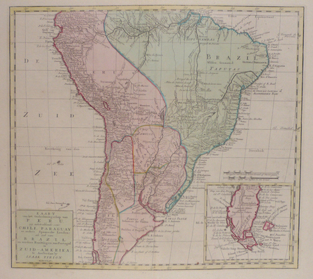
TIRION (Isaak).
Kaart van het onderkoningschap van Peru, ... Chili, Paraguay ... Brazil ... in Zuid-Amerika.
Amsterdam, 1765. 360 x 398 mm.
书商的参考编号 : LBW02482
|
|
|
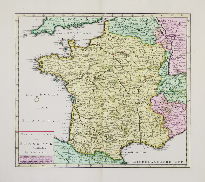
TIRION (Isaak).
Nieuwe kaart van Frankryk.
Amsterdam, [circa 1730]. 329 x 375 mm.
书商的参考编号 : LBW-4941
|
|
|
TIRION (Isaak);
Nieuwe kaart van het westelykste deel der weereld ... naar Westindie.
Amsterdam 1754 340 x 362 mm.
书商的参考编号 : LBW0247b
|
|
|
TIRPENNE & MONTHELIER.
LYON (Rhône).
Paris, Benard, [circa 1850]. 221 x 292 mm.
书商的参考编号 : LBW03d51

|
|
|
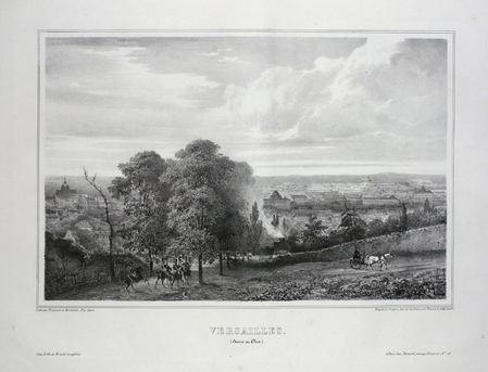
TIRPENNE & MONTHELIER.
VERSAILLES (Seine et Oise).
Paris, Benard, [circa 1850]. 222 x 293 mm.
书商的参考编号 : LBW03d74
|
|
|
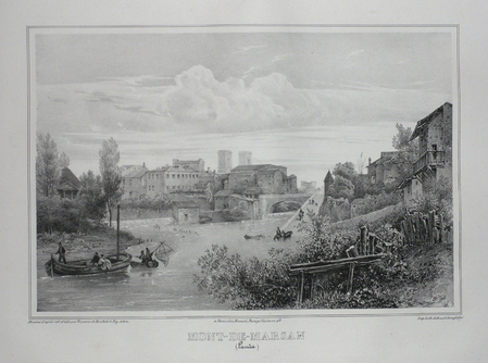
TIRPENNE;MONTHELIER;
MONT-DE-MARSAN (Landes).
Paris Benard circa 1850 221 x 295 mm.
书商的参考编号 : LBW03d6e
|
|
|
TIRPENNE;MONTHELIER;
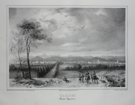
TARBES (Hautes Pyrénnées).
Paris Benard circa 1850 219 x 281 mm.
书商的参考编号 : LBW03d5d
|
|
|
TISSANDIER Gaston ( Rédacteur En Chef )
La Nature. Revue Des sciences et De Leurs Applications Aux Arts et à L'industrie. Vingt-Huitième Année, 1900
Paris G. Masson 1900 GRAND In-8 427 pp, Journal hebdomadaire illustré. année complète avec la table des matières , fleuron et titre sur pièce de titre en cuir
书商的参考编号 : 31001
|
|
|
TISSOT
Tours de cartes, recueil complet
Paris Delarue s.d. (vers 1890) in-8 br., couv. illustrée
书商的参考编号 : 17049
|
|
|
TITE-LIVE; CLERICUS Joannes (préf. et notes):
Titi Livii historiarum quod exstat, cum integiris Joannis Freinshemii supplementis...
Amstelaedami, Apud Henricum Wetstenium, 1710. 10 vol. in-8 de [30]-455 + 490 + 470 + 446 + 460 + 495 + 506 + 496 + 504 + 363 pages. Pleine basane marron, dos à nerfs ornés de filets et fleurons à froid, pièces de titre et tomaison blondes. Dos frottés, accroc aux coiffes sup. des vol. 1 et 7, accroc aux coiffes inf. des vol. 1 et 8, coiffe inf. vol. 7 manquante, mors 1er plat fendus en leur part. inf. sur les vol. 7 et 10, pièce de titre manquante au vol. 10.
书商的参考编号 : 2869

|
|
|
TOCQUET Robert
La prestidigitation à la porté de tous.
Paris, N.O.E., 1977. 14 x 22, 191 pp., broché, état moyen (couverture défraîchie).
书商的参考编号 : 36707
|
|
|
TOCQUET Robert
Les tours de carte à la porté de tous.
Paris, N.O.E., 1977. 14 x 22, 189 pp., broché, état moyen (couverture défraîchie).
书商的参考编号 : 36708
|
|
|
TOCQUET Robert
LES TOURS DE CARTES A LA PORTEE DE TOUS
1977 broché in-octavo, couverture recto ornée dune illustration photographique, illustrations : frontispice et figures in-texte, 189 pages, 1977 Paris Productions de Paris-N.O.E.,
书商的参考编号 : 5315
|
|
|
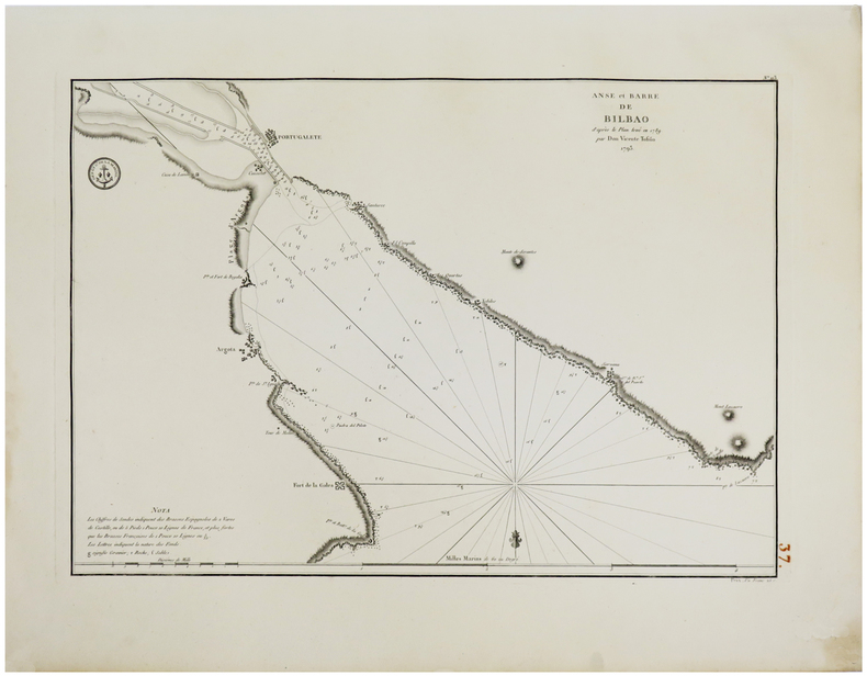
TOFIÑO de SAN MIGUEL (Don Vicente).
[PAYS BASQUE] Anse et barre de Bilbao d'après le plan levé en 1789 par Don Vicente Tofiño. 1793.
1793. 367 x 523mm.
书商的参考编号 : LBW-1807
|
|
|
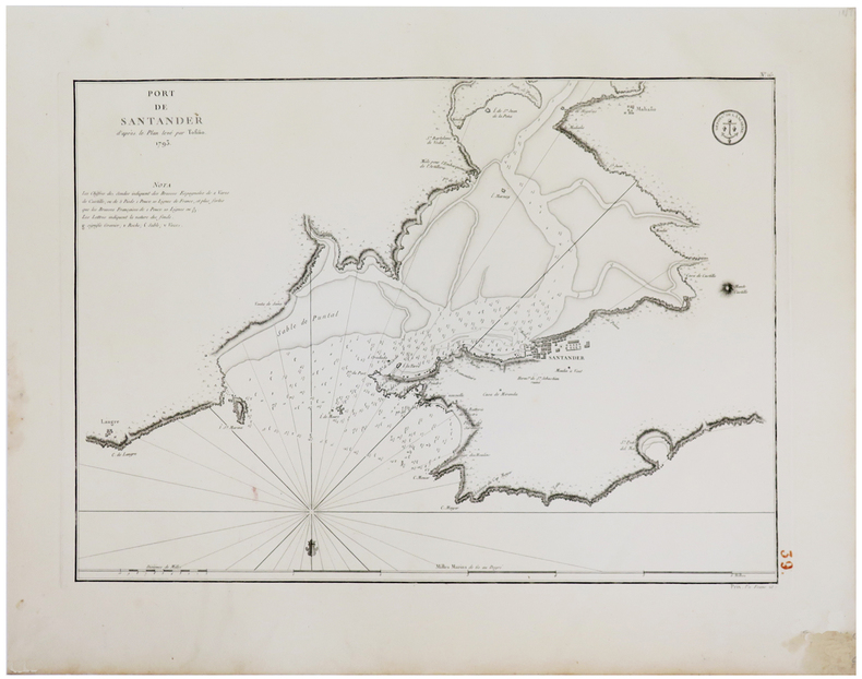
TOFIÑO de SAN MIGUEL (Don Vicente).
[PAYS BASQUE] Port de Santander d'après le plan levé par Tofiño. 1793.
1793. 372 x 526 mm.
书商的参考编号 : LBW-1804
|
|
|
TOFIÑO de SAN MIGUEL (Don Vicente).
[PAYS BASQUE] Port de Santoña d'après le plan levé en 1789 par Tofiño. 1793.
1793. 372 x 527 mm.
书商的参考编号 : LBW-1803

|
|
|
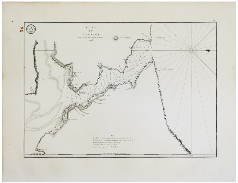
TOFIÑO de SAN MIGUEL (Don Vicente).
[PAYS BASQUE] Port du Passage d'après le plan levé en 1788 par Tofiño. 1793.
1793. 369 x 525 mm.
书商的参考编号 : LBW-1806
|
|
|
Togni, Roberto - Forni, Gaetano - Pisani, Francesca
Guida ai musei etnografici italiani. Agricoltura, pesca, alimentazione e artigianato.
cm. 17 x 24, 340 pp. con 269 ill. n.t. di cui 47 a colori. Biblioteca di ?Lares? Il sorgere in qualche decennio di molte centinaia di musei attinenti le tradizioni popolari costituisce il pi? straordinario processo di musealizzazione di tutti i tempi. Qui per la prima volta viene analizzato, sotto il profilo storico-antropologico con ampissimo respiro pluridisciplinare, il loro ricco contenuto e, per ciascuno di essi, vengono fornite le caratteristiche e le informazioni logistiche essenziali. N? viene tralasciata una sintetica comparazione con i musei di questi tipo degli altri Paesi. Un manuale prezioso per le pi? diverse categorie di specialisti: museologi, etnologi, insegnanti, amministratori pubblici, architetti, storici ecc. The birth of several hundred museums pertaining to popular traditions within a matter of decades constitutes the most extraordinary process of 'museum-consciousness' of all times. For the first time under an historical-anthropological profile with ample multi-disciplinary views their rich contents are closely examined and their distinctive features plus essential logistical information are provided for each one. A synthetic comparison between similar museums in other countries is also included. A precious manual for the various categories of specialists: museum scholars, ethnologists, teachers, public administrators, architects, historians etc. 801 gr. 340 p.
|
|
|
Tokyo Maps Tony Buzan Translated by Tetsu Sato
a book that makes you smart
Tokyo Maps Tony Buzan Translated by Tetsu Sato 1986. Soft Cover. Fine. The book is in fine condition. Tokyo Maps Tony Buzan Translated by Tetsu Sato paperback
书商的参考编号 : 2083002116201994
|
|
|
Toland John author; Kuhl Jerome maps
THE BATTLE OF THE BULGE LANDMARK BOOKS 114
New York: Landmark Books Random House 1966. Hardcover. Octavo; G-/no DJ; Hardcover w/out DJ; Spine white with red print; Boards in illustrated cloth wear to corners and spine caps toning to spine edgewear/shelfwear; Text block has name in ink on front endpapers cracked hinges front and rear clean text light age-toning to paper; 178 pages frontispiece illustrated b&w. 1326637. FP New Rockville Stock. Landmark Books, Random House hardcover books
书商的参考编号 : 1326637
|
|
|
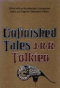
Tolkien, J. R. R.; Tolkien, Christopher [intro., commentary, index, maps]
Unfinished Tales of Numenor and Middle-Earth
Unwin Hyman 1980. Book. Near Fine. Hardcover. 8vo - over 7¾ - 9¾" tall. Burgundy cloth hard covers in dust jacket. First edition first printing; overseas issue without price on dust jacket. Folding map to rear still fine. Top edge dyed burgundy lightly spotted. A little spotting to bottom edge. Jacket shows slight handling wear only and light crease to rear; now protected in new removable archival mylar sleeve. Otherwise clean tight and unmarked. Very neat -- a sound and handsome copy. . Unwin Hyman Hardcover
书商的参考编号 : 85356h ???????? : 0048231797 9780048231796

|
|
|
Tolkien, J. R. R. Edited w/Commentary, Index and Maps By Tolkien, Christopher
Unfinished Tales of Numenor and Middle-Earth
Boston: Houghton Mifflin Harcourt 1980. Book. Fine. Hardcover. First Edition/First Printing. A square solid tight clean unread copy. The 15.00 unlaminated jacket as issued has some lightish rubbing wear some edge wear some edge chipping two short closed tears. Light green cloth boards with silver/green inlay. First US Edition. A very nice overall copy in a worn jacket. Map by Christopher Tolkien tipped to rear endpaper as issued has neber been removrf from this copy. THIS COPY IS IN MY POSSESSION AND WILL NORMALLY SHIP NEXT DAY. Houghton Mifflin Harcourt Hardcover
书商的参考编号 : 047136 ???????? : 0395299179 9780395299173
|
|
 ?????????
 ?????PDF???
 RSS feed


