|
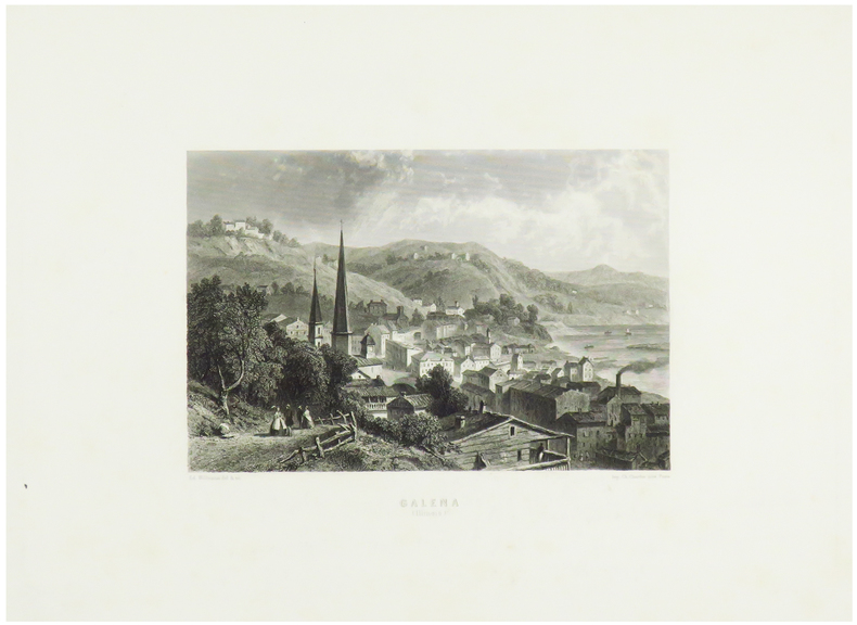
WILLMANN (Edward).
Galena (Illinois).
Paris, [circa 1860]. 131 x 172 mm.
Referentie van de boekhandelaar : LBW-1248
|
|
|
WILSON, Robert Thomas
History Of The British Expedition To Egypt; To Which Is Subjoined A Sketch Of The Present State Of That Country And Its Means Of Defence; Illustrated With Maps And Portraits of Sir Ralph Abercromby
London: T. Egerton, 1803. in-4° , (270x215) , relié demi basane et coins , dos lisse avec pièce de titre et auteur, xxi-387pp , frontispice , 2 tableaux dépliants et 3 cartes dépliantes légèrement coloriées ,quelques rousseurs , déchirure à une carte sans manque ,ex-libris charles Kettaneh, bon exemplaire .
Referentie van de boekhandelaar : PHO-893

|
|
|
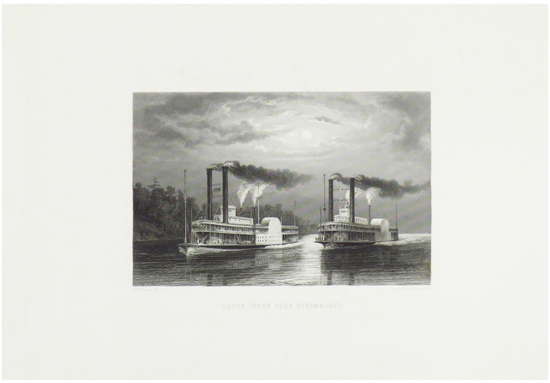
WILLMANN (Edward).
Lutte entre deux steamboats.
Paris, [circa 1860]. 125 x 170 mm.
Referentie van de boekhandelaar : LBW-1249
|
|
|
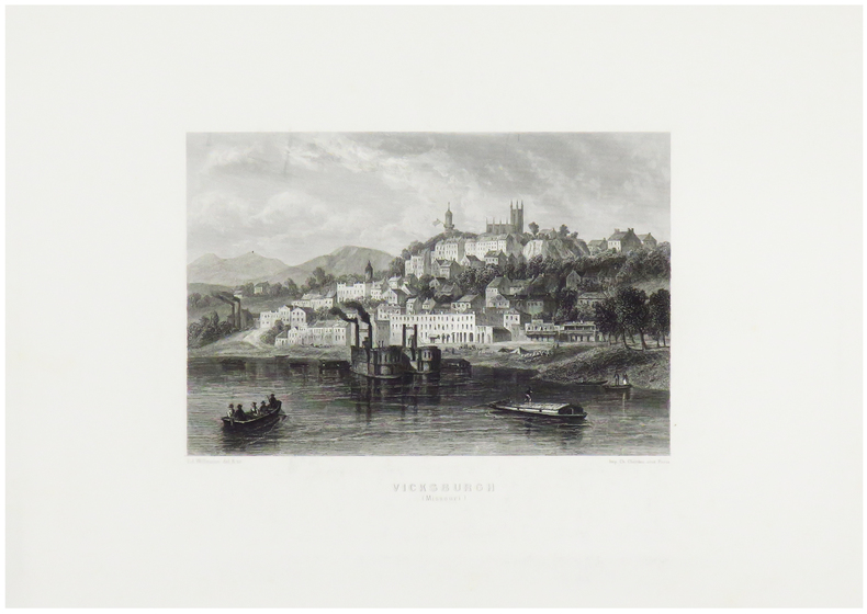
WILLMANN (Edward).
Vicksburgh (Missouri).
Paris, [circa 1860]. 130 x 170 mm.
Referentie van de boekhandelaar : LBW-1247
|
|
|
Wild World Of Maps, Inc Staff, and Wide World Of Maps
Tucson Metropolitan Street Atlas
Wide World of Maps Incorporated 1999. Unabridged. Spiralbound. Fine. Trade paperback US. Wide World of Maps, Incorporated unknown
Referentie van de boekhandelaar : Alibris.0013442 ISBN : 1887749160 9781887749169
|
|
|
Will Durant; Illustrator-Glossy B&W illust. EP Maps
Life of Greece "the Story of Civilization" Series Part 2 II Two
simon & schuster Pub 1966-01-01. Unknown Binding. Very Good. Nice looking book has minor edge wear.dusk jacket is faded & has tears.Pages are tan and not crisp white. simon & schuster Pub unknown
Referentie van de boekhandelaar : 641110222004
|
|
|
Willett, B. M. . [et al.] (eds.)
Philip's Modern School Atlas
85th edition. Fine hbk bound in glazed pictorial boards. Co-editors, D. Gaylard, L. Prince-Smith, J. Russell, R. Smith, A. Wells. ISBN 0540055549. 21219. eng
|
|
|
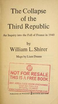
William l. Shirer; Liam Dunne (maps)
The Collapse of the Third Republic: An Inquiry into the Fall of France in 1940
New York NY: Pocket Books July 1971. First Thus. Mass Market PaperBack . Very Good. Pocket mass market edition. Not abridged. Mild shelfwear. Slightly bowed spine. 1116 pages Pocket Books paperback
Referentie van de boekhandelaar : 291173 ISBN : 0671785095 9780671785093
|
|
|
William Napier; et al; Photos & Maps [Illustrator]
Pacific Voyages: The Encyclopedia of Discovery and Exploration
Doubleday & Co. Inc. Garden City 1973-01-01. Hardcover. New. New. In shrink wrap. Looks like an interesting title! Doubleday & Co., Inc., Garden City hardcover
Referentie van de boekhandelaar : Q-038504335X ISBN : 038504335X 9780385043359

|
|
|
Williams, Jay. Maps By Richard Edes Harrison
The Battle for the Atlantic. Landmark Books Series No. 87
Random House. Used - Good. Good condition. Acceptable dust jacket. #87. juvenile nonfiction world war ii naval operations A copy that has been read but remains intact. May contain markings such as bookplates stamps limited notes and highlighting or a few light stains. Random House unknown
Referentie van de boekhandelaar : S08OS-01817
|
|
|
Williams, Jay. Maps By Richard Edes Harrison
The Battle for the Atlantic. Landmark Books Series No. 87
Random House 1959. hardcover. Very Good. 8x5x0. Random House hardcover
Referentie van de boekhandelaar : 231102105
|
|
|
Williams, Jay. Maps By Richard Edes Harrison
The Battle for the Atlantic. Landmark Books Series No. 87
Random House. Collectible - Good. First edition copy. Collectible - Good. Good dust jacket. World War 2 Atlantic Ocean Random House unknown
Referentie van de boekhandelaar : S01Q-00484
|
|
|
Williams, Jay. Maps By Richard Edes Harrison
The Battle for the Atlantic. Landmark Books Series No. 87
Random House. Used - Acceptable. Acceptable condition. Good dust jacket. Book 87 in Landmark Series. Juvenile Historical Fiction History United States History A readable intact copy that may have noticeable tears and wear to the spine. All pages of text are present but they may include extensive notes and highlighting or be heavily stained. Includes reading copy only books. Random House unknown
Referentie van de boekhandelaar : SB09E-01354
|
|
|
Wills, F. Alex (The Vagabond)
The English Gate (Northumberland)
No marks or inscriptions. No creasing to covers or to spine. A very clean very tight copy with bright unmarked slightly sunned orange cloth boards, rubbing to a small number of page edges and bumping to lower front corner. 242pp. Historical and touring account of the county of Northumberland. Illustrated. Undated ca 1950.

|
|
|
Wilson, Geoff (Text) and Classon, Bill (Maps)
FISHING VICTORIA'S COASTLINE
South Croydon: Australian Fishing Network. Fine. 2002. First Edition. Paperback. 1865130338 . With colour photographic illustrations and many maps a fine copy. This book is light and postage will be reduced for shipment within Australia. ; 300 x 220mm; 112 pages . Australian Fishing Network paperback
Referentie van de boekhandelaar : 20138 ISBN : 1865130338 9781865130330

|
|
|
Wilson, H. L. & Clayton Jones, H.
Mountain Skylines and Place Names in Llandudno and District
No marks or inscriptions to contents. No creasing to covers. A clean tight booklet with slightly foxed boards, mark to rear (ink ?), rusty staples and no bumping to corners. 24pp. In three parts - 'Guide to the Welsh pronunciation', 'Mountains in the vicinity of Llandudno' and 'Welsh Place Names in Llandudno and District'. Undated ca 1900.

|
|
|
Wilson, Martin Anthony
Unwind by Water in Lakeland
Book in mint unread condition. 132pp. For those who come to the Lake District to unwind and enjoy some time relaxing in a glorious waterside setting. This book tells you the places to go.

|
|
|
Wilson, Robert H. (Editor).
PHILADELPHIA. Official Handbook for Visitors.
128p. Illustrated with numerous photographs, many in color, and maps. 16mo. Original wraps very soiled. PA PAMPH 20_18 BX6
|
|
|
Winchester Simon; Wong Cezanne Maps & Charts
Pacific Nightmare: A Third World War In The Far East
Sidgwick & Jackson Ltd. Very Good in Very Good dust jacket. 1992. First Edition; First Printing. Hardcover. 0283061065 . Book and DJ have mild edgewear 4 pages have small wrinkle to fore-edge w/tiny tear to 2 of those pages little bit of very light soiling to page ends; DJ has light toning to flaps little bit of wrinkling to edges 2 small faint moisture marks to interior front edge that doesn't show through; DJ in protective Brodart cover ; 302 pages . Sidgwick & Jackson Ltd hardcover
Referentie van de boekhandelaar : S1933 ISBN : 0283061065 9780283061066

|
|
|
Winsor, Justin; Boston.
MEMORIAL HISTORY OF BOSTON - INLCLUDING SUFFOLK COUNTY, MASSACHUSETTS. 1630-1880. Four Volume Set.
Four Volumes. pp. 596; 577; 691; 713 + Folded two page map of Boston in color, and other illustrations, maps etc. 4to. Original full cloth binding; somewhat worn and stained. XLib. Skidompha Library, Damriscotta, ME. **PRICE JUST REDUCED! NEW ENG 4
|
|
|
Winston Halstead (editor)
Lancashire Magazine : Autumn 1978
No marks or inscriptions. Light creasing to covers. A very clean very tight copy with bright unmarked boards and no bumping to corners. 71pp. Features on Clitheroe and Gisburn, curious Lancashire, Ferries across the Mersey, fashion, leisure, local history.

|
|
|
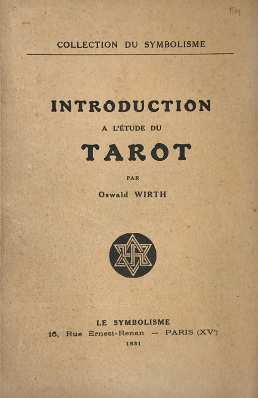
Wirth (Oscar) :
Introduction à l'étude du Tarot.
Paris, Le Symbolisme, 1931 ; in-8, broché ; 49 pp., (3) ff. de table, achevé d'imprimer, le dernier blanc, couverture beige imprimée, nombreuses figures in-texte.
Referentie van de boekhandelaar : 14773
|
|
|
WIRTH Thierry
LA PROVENCE LA COTE D'AZUR A LA BELLE EPOQUE
Bruxelles, SODIM, 1976, 1 vol. in-4, reliure d'éditeur illustrée, de 214 reproductionsde cartes postales,
Referentie van de boekhandelaar : 10968
|
|
|
Wisconsin State Planning Board & Wisconsin Conservation Commission, maps B/W photographs
A Park Parkway and Recreational Area Plan Wisconsin State Planning Board and Conservation Commission
Wisconsin State Planning Board Wisconsin Conservation Commission 1939. 134 pp. foldout map rebound in buckram hardcover ex library covers rubbed several pages lightly creased at top corner or fore edge glue residue to front free endpaper else text clean and binding tight. - If you are reading this this item is actually physically in our stock and ready for shipment once ordered. We are not bookjackers. Buyer is responsible for any additional duties taxes or fees required by recipient's country. Wisconsin State Planning Board, Wisconsin Conservation Commission hardcover
Referentie van de boekhandelaar : ZB783545
|
|
|
WIT (Frederick de).
[DAUPHINÉ] Gouvernement général du Dauphiné, divisé en Haut et Bas, et subdivisé en ses sept pays, sçavoir le Graisivaudan, le Viennois, le Valentinois, le Diois, le Gapençois, l'Embrunois et le Briançonnois, et en plusieurs balliages.
Amsterdam, F. de Witt, [circa 1680]. 454 x 557 mm.
Referentie van de boekhandelaar : LBW-9006

|
|
|
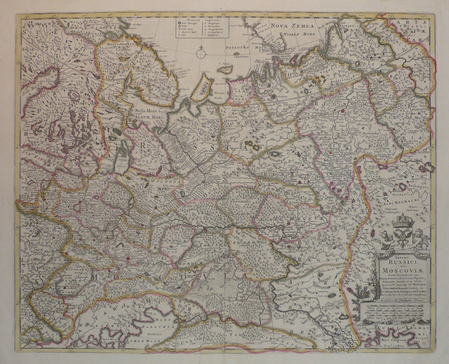
WIT (Frederick de).
[RUSSIE] Imperii Russici, sive Moscoviae.
London, Christopher Browne, [circa 1700]. 450 x 558 mm.
Referentie van de boekhandelaar : LBW04171
|
|
|
Witzig Roland:
Dolce Vita - étiquette de vin.
Etiquette pour un blanc d'Epesses, domaine Wannaz à Chenaux, 1985.
Referentie van de boekhandelaar : 1901

|
|
|
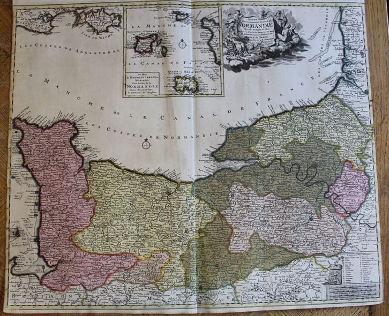
WITT (F. De).
Duché et Gouvernement de Normandie divisé en Haut et Bas en divers Pays et Bailliages avec le Gouvernement General de Havre de Grace.
Amsterdam, F. De Witt avec Privilège des Etats d'Hollandeet de Westfrise, s.d. (ca 1700-1708). Carte de 600 x 525 mm. Baillages mis en couleurs et cartouche central avec les îles anglo-normandes Garnezy, Ierzay et Aurigny. En très bon état, sans marges latérales
Referentie van de boekhandelaar : 22401
|
|
|
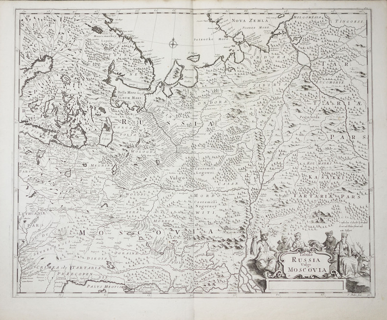
WIT (Frederick de).
Tabula Russia vulgo Moscovia.
vers 1700. 450 x 558 mm.
Referentie van de boekhandelaar : LBW-2278
|
|
|
Witzig Roland:
Witzig - Petite sérigraphie signée.
Lausanne, La Marge. Sérigraphie en noir, au format 11 x 21 cm.
Referentie van de boekhandelaar : 26120

|
|
|
Wittemberg:
Wittemberg. "Plan der Action, welche d. 2.Oct. 1760 zwischen einem Kön. Preussischen Corps und einem Corps der Kayseerlichen und Reichs Armee bey Wittemberg vorgefallen." Schlachtenplan von Wittemberg, links mit Legende. Kupferstich mit farbigen Truppenaufstellungen aus "Neues Kriegs-Theater ...", 23. Supplement.
Format: 18 x 29,5 cm. *Leicht gebräunt, insgesamt gut erhalten. Landkarten de
|
|
|
Witzleben, A. von
Deutschlands Militär-Literatur im letzten Jahrzehnt und Übersicht der wichtigsten Karten und Pläne Central-Europas.
Bln., Mittler 1850. VII, 247 S., HLn. m. gldgepr. Rückentit., Kanten leicht bvestoß., Bibl.-Stemp. u. hs. Vermerk am Innentit., schwach stockfl.
Referentie van de boekhandelaar : BIBG0021
|
|
|
Woerl, Joseph Edmund [1803-1865]:
Die Badischen Bäder. Baden, Rippoldsau, Griesbach, Hub, Petersthal, Erlenbad, Antogast, Freiersbach etc. oder Specialkarte der Gegend zwischen Strassburg, Carlsruhe, Offenburg und Freudenstadt. Maßstab 1 : 135 000.
Lithographierte Karte, auf Leinen aufgezogen in 15 Segmenten. 55 x 48 cm, gefaltet: 17 x 12 cm. In Orig.-Halbleinenmappe. *Datierung nach den Angaben zu dem Exemplar der Universitätsbibliothek Basel. Landkarten de
|
|
|
WOLFF (Jeremias).
[BERNE] Bern in der Schweitz.
Augsbourg, Hæred Jer. Wolffÿ, [circa 1720]. En 2 feuilles jointes formant une vue de 0,34 x 1,05 m.
Referentie van de boekhandelaar : LBW-8838

|
|
|
WOLFE, JAMES.
Sailing Directions for the Lower Shannon and the Lough Derg.
London, Admiralty, 1843 8vo. In recent half cloth with gilt stamp and lettering to front board. Small paper label pasted on to verso front board and two stamps to title-page. Internally fine and clean. 32 pp.
Referentie van de boekhandelaar : 57129
|
|
|
Wolbling, Jutta
Die Wesermarsch von Oben
No marks or inscriptions. Crease to lower corner of soft front cover. Rear cover is sunned stiff card. A very clean very tight copy with no bumping to corners. Single-sided with interleaved tissue. 16pp. Aerial views of Weser Marsh in northern Germany. All text in German.

|
|
|
Woldan, Erich
Die ältesten gedruckten modernen Karten Afrikas.
Wien, Verlag der Österreichischen Akademie der Wissenschaften, 1981. S. 252-257. Mit 8 Taf. (= Veröffentlichungen der Kommission für Geschichte der Mathematik, Naturwissenschaften und Medizin, H. 34 / Sonderabdruck aus dem Anzeiger der phil.-hist. Klasse der Österreichischen Akademie der Wissenschaften, Jg. 118, So. 15). Gr.-8vo. OBrosch.
Referentie van de boekhandelaar : 60980
|
|
|
WOLFE, JAMES.
Sailing Directions for the Lower Shannon and the Lough Derg.
London, Admiralty, 1843 8vo. In recent half cloth with gilt stamp and lettering to front board. Small paper label pasted on to verso front board and two stamps to title-page. Internally fine and clean. 32 pp.
|
|
|
WOLFF Jeremias (1633 - 1724)
Roma
Rara veduta panoramica della città edita dagli eredi di Jeremias Wollf ad Augsburg. La stampa, corredata da una legenda di 17 voci, mostra numerosi personaggi e animali sul primo piano. Il Tevere segue l'errato corso tipico di tutte le vedute della città di produzione nordica, tuttavia in questa incisione gli edifici sono disegnati in maniera molto più realistica e corrispondente al vero. Il prototipo iniziale per questa tipologia di panorami è identificabile nella veduta generale incisa da Israel SIlvestre nel 1642.Incisione in rame, coloritura coeva, in ottime condizioni. Rare panorama of the city edited by the heirs of Jeremias Wollf in Augsburg. The print, accompanied by a 17-item key-legend, shows numerous characters and animals in the foreground. The Tiber follows the wrong course typical of all city views of Nordic production, but in this engraving the buildings are drawn in a much more realistic way and correspond to reality. The initial prototype for this type of panorama can be identified in the general view engraved by Israel SIlvestre in 1642. Copper engraving, contemporary coloring, in very good condition. C. Marigliani, "Le Piante di Roma delle collezioni private", tav. 105.

|
|
|
Wolff, Leon, with Lyn Macdonald & Major-General JFC. Fuller (maps by Reginald Piggott) J. F.
In Flanders Fields - Folio Society edition The 1917 Campaign
The Folio Society London 2003. First printing. Octavo; hardcover; illustrated boards gray endpapers; 298pp. with a monochrome photographic frontispiece 16pp. of plates likewise and many maps. Minor wear only; near fine in brown slipcase. Postage quoted is for a standard format octavo book. Final charges may vary depending on size and weight. The Folio Society, London, 2003. hardcover
Referentie van de boekhandelaar : 78984
|
|
|
Wonson, M. R.; Cowan, Georgina
Devon: Coast, countryside, forest and moors (A Geographia guide)
No marks or inscriptions. No creasing to covers or to spine. A very clean very tight copy with bright unmarked boards, minor traces of storage and no bumping to corners. Large fold-out map at rear in excellent condition. 128pp. Guide to the towns, cities, villages and places of interest in Devon.
|
|
|
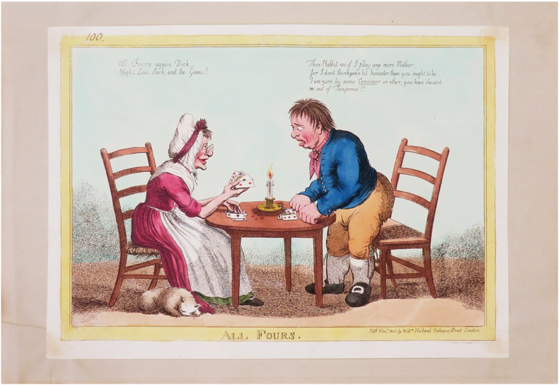
WOODWARD (George Moutard).
All Fours.
London, W.m Holland, 1805. 245 x 346 mm ; monté sur papier.
Referentie van de boekhandelaar : LBW-8544
|
|
|
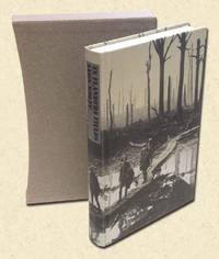
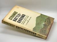
Wood, Herbert Fairlie. Maps by E. H. Ellwand
STRANGE BATTLEGROUND. The Operations in Korea and Their Effects on the Defence Policy of Canada
Ottawa: The Minister of National Defence 1966. Hardcover. Very Good/Good. 1st edition thus 1966. A Very Good book in a Good dust jacket. 8vo. 317 pp. with fold out maps bound in publishers red cloth with illustrated dust jacket $8.50. Jacket spine is tanned light chipping along edges with overall light soiling. Text appears unmarked dust jacket now protected in mylar sleeve. The Minister of National Defence hardcover
Referentie van de boekhandelaar : 35740
|
|
|
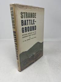
Wood, Lt. Col. Herbert Fairlie; Sergeant EH. Ellwand (Illustrations & Maps) E. H.
Strange Battleground: Official History of the Canadian Army in Korea;
Ottawa Ontario Canada: Roger Duhamel Queen's Printer & Controller of Stationery 1966. First Edition First Printing. Hardcover. pp. x 317. Royal 8vo. Bound in full red cloth over boards with gilt lettering to the spine and heraldic device embossed to the centre of the front board; map endpapers. Colour frontispiece and richly illustrated with many plates of colour maps throughout as well as two fold-out maps. Excepting some faint foxing to the foredges the extremities are entirely without blemish contents remain equally bright clean and unmarked with tight sound binding; near fine and housed in very good lightly rubbed dustjacket showing some foxing and edgewear. Overall very good. <br/><br/> Roger Duhamel, Queen's Printer & Controller of Stationery hardcover
Referentie van de boekhandelaar : 2964
|
|
|
Wood, W. B. ; Major Edmonds
Military History of the Civil War 1861 - 1865
10.5: wide x 13.5 tall book is in near fine condition with faint mark to front cover, light general scuffing. Binding is solid and square, covers have sharp corners, exterior shows no other blemishes in deep blue cloth, text/interior is clean and free of marking of any kind and is filled with full and double-page b&w and color illustrations, detailed maps, elaborate bright red illustrated endpapers. Unpaginated, about 250 pages. Dust jacket shows a closed tear 1", edge wear, general scuffing.

|
|
|
Woodcock, Tim
Classic Mountain Bike Rides in Britain
No inscriptions or marks. A lovely clean crisp very tight copy with bright unmarked boards and no bumping to corners. Dust jacket not price clipped or torn with very light creasing to upper edge and traces of shelf rubbing. 160pp.

|
|
|
Woolf, Virginia) Bell, Quentin and Maps on End Papers; b/w Photos
Virginia Woolf: Vol.2: Mrs Woolf 1912-1941: A Biography
Hardcover. Very Good. Near fine book & jacket hardcover
Referentie van de boekhandelaar : Y4-80S1-CTV5
|
|
|
Works Progress Administration; Federal writers' Project; Maps [Illustrator]
Washington - City and Capital American Guide Series
Government Printing Office 1937. hardcover. Very Good. 0x0x0. Bound in publisher's cloth. Hardcover. No dust jacket. Good binding and cover. Spine faded. Clean unmarked pages. Includes map in rear pocket. xxvi. 1140 pages. <br> The American Guide Series was a group of books and pamphlets published under the auspices of the Federal Writers' Project FWP a Depression-era works program in the United States. The American Guide Series books were compiled by the FWP but printed by individual states and contained detailed histories of each state with descriptions of every city and town. The format was uniform comprising essays on the state's history and culture descriptions of its major cities automobile tours of important attractions and a portfolio of photographs. Government Printing Office hardcover
Referentie van de boekhandelaar : 2306200115
|
|
|
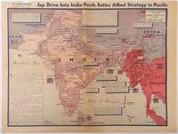
WORLD WAR II MAP BURKE HOWARD; CAB. C. A.
Jap Drive into India perils entire Allied strategy in Pacific
Los Angeles.: Los Angeles Examiner. April 31944. Colour pictorial map on a single newspaper leaf 37 x 50 cms; 41.5 x 54.6 cms sheet unrelated text on the verso although with an interesting account from a soldier's letter about an air raid in China toning more marked at the central fold two small splits no loss to the map edge wear with several small marginal edge tears neatly repaired on the verso with archival washi map unaffected in good condition. A dynamic map prepared and illustrated by the Examiner's art critic and editor Howard Burke covering the area surrounding India and Central Asia showing Japanese conquered territory in Malaya Thailand Indo-China and Burma; and in India British-controlled states and native feudal and protected states. <br> <br>Text boxes and pictographs give an overview of the geopolitical situation from the Allied perspective. One box notes "Chanda Bose has many adherents and fanatical followers in Bengal. They may prove to be a powerful fifth column in India". Text at lower edge opines "The situation in India is critical and has grown more so as the all-out offensive against Japan has been delayed. If the Allies do not act at once and with great force all our gains may be wiped out and the war in the Pacific prolonged indefinitely." <br> <br>The decisive and devastating bombings that were to signal such an end were four months away. <br> <br>Rare on the market. . Los Angeles Examiner. unknown
Referentie van de boekhandelaar : 214362
|
|
|
Wright, Chris, PhD, Text and Maps Prepared By
Korea: Its History and Culture
Korean Overseas Information Service 1996. Call numbers on label around edge of spine marked out bar code on front cover library name stamp on early page crease on lower rear corner abou 1/2" from tip. 137 pages. Soft Cover. Very Good. 8vo - over 7¾" - 9¾" tall. Ex-Library. Korean Overseas Information Service Paperback
Referentie van de boekhandelaar : 020556 ISBN : 8973753029 9788973753024

|
|
 De zoekresultaten per email ontvangen
 Zoekresultaten downloaden als PDF
 RSS feed


