Nicholson 2019. Spiral-bound. Good. Pages can have notes/highlighting. Spine may show signs of wear. ~ ThriftBooks: Read More Spend Less.Dust jacket quality is not guaranteed. Nicholson unknown
Référence libraire : G0008309396I3N00 ISBN : 0008309396 9780008309398
Collins 2018. Paperback. New. <p><strong>Author:</strong> Collins Maps</p><p><strong>Publisher:</strong> Collins</p><p><strong>Binding:</strong> Paperback</p><p><strong>ISBN:</strong> 9780008225087</p><p><strong>Release Date:</strong> 2018</p><p><strong>Number Of Pages:</strong> 1</p><p><strong>Details:</strong> This unique pictorial map shows the ancient territories of the principal Scottish clans in the 17th century and features Don Pottinger’s Islay Herald of Arms distinctive and original artwork of Scottish arms and crest badges. The map includes over 170 arms the official insignia of clan chiefs and crest badges. It also includes a territories map of principal clans at the beginning of the 17th century; arms of the ancient Scottish principalities; and locations of the ancient territories held by the clans around the time of King James VI. The map is ideal for those those with an interest in Scottish heraldry clans and family history. The map is based on the map originally conceived and illustrated by the late Sir Iain Moncreiffe of that Ilk Bart. C.V.O. Q.C. Ph.D. Albany Herald of Arms and the late Don Pottinger C.V.O. M.A. D.A. Islay Herald of Arms.</p> Collins paperback

Référence libraire : 9780008225087-2025 ISBN : 0008225087 9780008225087
Collins 2018. Paperback. New. <p><strong>Author:</strong> Collins Maps</p><p><strong>Publisher:</strong> Collins</p><p><strong>Binding:</strong> Paperback</p><p><strong>ISBN:</strong> 9780008225087</p><p><strong>Release Date:</strong> 2018</p><p><strong>Number Of Pages:</strong> 1</p><p><strong>Details:</strong> This unique pictorial map shows the ancient territories of the principal Scottish clans in the 17th century and features Don Pottinger’s Islay Herald of Arms distinctive and original artwork of Scottish arms and crest badges. The map includes over 170 arms the official insignia of clan chiefs and crest badges. It also includes a territories map of principal clans at the beginning of the 17th century; arms of the ancient Scottish principalities; and locations of the ancient territories held by the clans around the time of King James VI. The map is ideal for those those with an interest in Scottish heraldry clans and family history. The map is based on the map originally conceived and illustrated by the late Sir Iain Moncreiffe of that Ilk Bart. C.V.O. Q.C. Ph.D. Albany Herald of Arms and the late Don Pottinger C.V.O. M.A. D.A. Islay Herald of Arms.</p> Collins paperback
Référence libraire : 9780008225087-2025 ISBN : 0008225087 9780008225087
Collins 2018. Paperback. New. <p><strong>Author:</strong> Collins Maps</p><p><strong>Publisher:</strong> Collins</p><p><strong>Binding:</strong> Paperback</p><p><strong>ISBN:</strong> 9780008285647</p><p><strong>Release Date:</strong> 2018</p><p><strong>Number Of Pages:</strong> 1</p><p><strong>Details:</strong> Handy little full colour Collins map of Skye with a high level of detail. Clear mapping of the Isle of Skye showing the road network ferries and places of interest. Map at a scale of 1:175 000 3 miles to 1 inch.Clear detailed full colour Collins road mapping is presented in a handy format ideal for the pocket or handbag. It is excellent value and covers the whole of the Isle of Skye.INCLUDES• Scotland route map• Caravan and camping sites• Tourist locations• Ferry links• Listing of major places to visit with additional details for Dunvegan Castle Old Man of Storr and Loch Coruisk• Detailed place names index</p> Collins paperback
Référence libraire : 9780008285647-2025 ISBN : 0008285640 9780008285647
Hardcover. New. New Book; Fast Shipping from UK; Not signed; Not First Edition; This atlas presents a complete view of the world bringing it to life through innovative maps stunning images and detailed content. hardcover
Référence libraire : ria9780008696061_inp ISBN : 0008696063 9780008696061
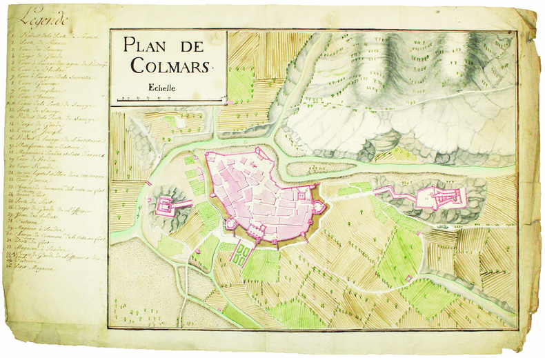
[circa 1750]. En deux feuilles jointes de 395 x 600 mm.
Plan manuscrit, encre et aquarelle, de la ville et des fortification de Colmars, au confluent du Verdon et de la Lance, dans les Alpes-de-Haute-Provence, portant le détail des rues de la ville, du tracé de son enceinte fortifiée, et des deux bastions qui la défendent (le fort Saint-Martin ou fort de Savoie et le fort du Calvaire ou fort de France). Des numéros sur le plan renvoient à une légende sur la gauche du plan donnant le nom de tous les ouvrages militaires. À l'extérieur de la ville sont figurés les cours d'eau, les zones rocheuses, les chemins et les parties cultivées. La petite ville de Colmars, située près de la frontière avec le duché de Savoie, fut une place royale dès 1593. L'enceinte a été construite vers 1690 d'après les plans de l'ingénieur Niquet, et les deux forts ont été construits, à la même époque, par Guy Creuzet de Richerand, directeur des fortifications du Dauphiné. Bien que le traité d'Utrecht de 1713, qui rattacha la vallée de l'Ubaye à la France, l'eut éloignée de la frontière avec la Savoie, la ville de Colmars demeura une place forte jusqu'en 1860. L'échelle est en toises. Trace de pliure. Marges écornées avec de petits manques n'affectant pas le dessin.