|
Glaser, Mordechai & Elgavi, Yvonne (translator)
Sinai and the Red Sea
Inscription opposite half-title page. No other marks A very clean very tight copy with bright unmarked boards and no bumping to corners. Dust jacket not price clipped or marked with rubbing to all edges.and corners and small enclosed tear to rear fore edge. Unpaginated ca 150pp. Description, culture, history and travel around the Sinai Peninsula of Israel and the Gulf of Elat. Extremely well illustrated.

|
|
|
Glazier, Captain Willard.
DOWN THE GREAT RIVER; EMBRACING AN ACCOUNT OF THE DISCOVERY OF THE TRUE SOURCE OF THE MISSISSIPPI, Together With Views, Descriptive and Pictorial, of the Cities, Towns, Villages. During a Canoe Voyage of over Three Thousand Miles from its Head Waters to
pp. 443, lii [Publisher's Appendix] + Portrait Frontis and full page plates, maps and a large folding map on tissue paper. Inked ownership of Clifton Wright, Oct. 6, 1888 from his father. Floral endpapers. 8vo. Original full cloth binding. Front board decorated with a design in gold and black of the Mississippi River and rear board decorated with the source of the river in Minnesota. Gilt lettered and decorated spine. Beveled edges. Small loss at head and tail of spine. Binding slightly soiled. Hardbound. AMERICANA BOX 4.
|
|
|
Gleeson, Ed w/maps by Richard Day
Erin Go Gray! An Irish Rebel Trilogy
<p>Carmel IN: Guild Press of Indiana 1997. 148pp. illus. paperback 8vo: Fine top cover corner is lightly thumbed; else a nice clean and crisp copy</p> Carmel, IN: Guild Press of Indiana paperback
Référence libraire : 22658 ISBN : 1578600189 9781578600182

|
|
|
Glenn Tucker; Dorothy Thomas Tucker, Maps [Illustrator]
Dawn like Thunder : The Barbary Wars and the Birth of the U.S. Navy
Bobbs 1963. hardcover. Very Good. 11x9x7. Hardcover. No dust jacket. Good binding and cover. Clean unmarked pages. Bobbs hardcover
Référence libraire : 2212070042
|
|
|
Global Graphics / GM Johnson Maps
California Missions State Map
NEW. unknown
Référence libraire : BIB-NOV-14-2025-358882 ISBN : 0918505801 9780918505804
|
|
|
Global Graphics / GM Johnson Maps
California Missions State Map
map. Good. Access codes and supplements are not guaranteed with used items. May be an ex-library book. unknown
Référence libraire : 0918505801.G ISBN : 0918505801 9780918505804
|
|
|
Global, MAPS
Foundations: Introduction to Supernatural Ministry
NEW. unknown
Référence libraire : BIB-NOV-15-2025-187295 ISBN : 9798849438434 9798849438
|
|
|
Global, MAPS
Foundations: Book 1 2022
NEW. unknown
Référence libraire : BIB-NOV-15-2025-188063 ISBN : 9798355201172 9798355201
|
|
|
Global, MAPS
Foundations: Christology
NEW. unknown
Référence libraire : BIB-NOV-15-2025-198813 ISBN : 9798846877897 9798846877
|
|
|
Global, MAPS
MAPS Foundations Second Edition
Independently published 2019. Paperback. New. 171 pages. 11.00x8.50x0.39 inches. Independently published paperback
Référence libraire : 1-1697158250 ISBN : 1697158250 9781697158250
|
|
|
Global, MAPS
MAPS Foundations: Introduction to Missions Theology of Prayer & Worship and The New Testament and Historical Missions
Independently published 2019. Paperback. New. 266 pages. 11.00x8.50x0.60 inches. Independently published paperback
Référence libraire : 2-1706194242 ISBN : 1706194242 9781706194248
|
|
|
Globus.
Globus terrestris ad sphaeram obliquam delineatus. Globus coelestis cum Astrodictico artificiali iunctus. Augsburg, Tobias Conrad Lotter, 1774.
Altkolorierter Kupferstich. Großfolio. Schöne altkolorierte Doppeldarstellung von Erd- und Himmelsglobus mit ausführlicher Beschreibung in deutsch-lateinischem Paralleltext.
|
|
|
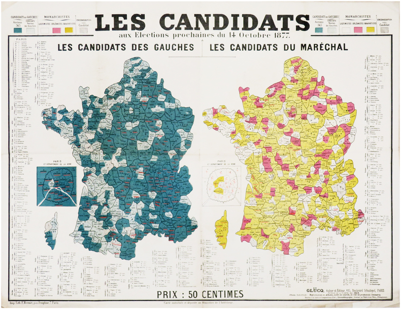
GLÜCQ (Gaston Lucq, dit).
[ÉLECTIONS LÉGISLATIVES de 1877] Les candidats aux élections prochaines du 14 octobre 1877.
Paris, Glücq, 1877. 472 x 623 mm.
Référence libraire : LBW-7601
|
|
|
GM Johnson Maps
Alaska / Yukon / Northwest Territories USA-Canada State-Province
GM Johnson Maps 20-04-2023. 2023. map. New. 9.00x4.25x0.20. Buy with confidence. Excellent Customer Service & Return policy. GM Johnson Maps unknown
Référence libraire : DADAX1774494000 ISBN : 1774494000 9781774494004
|
|
|
GM Johnson Maps
Blue Ridge Parkway Skyline Drive Route Map: From Front Royal Virginia to Great Smoky Mountains NP
G.M. Johnson & Assoc. Ltd. Vancouver BC. POSTER. 0. 9781770689961 :Folded size: 4.25" x 9" . NEW. G.M. Johnson & Assoc., Ltd. (Vancouver, BC) unknown
Référence libraire : 776428019657 ISBN : 1770689966 9781770689961
|
|
|
GM Johnson Maps
Hawaii State Map
NEW. unknown
Référence libraire : BIB-NOV-14-2025-363524 ISBN : 1774493926 9781774493922
|
|
|
GM Johnson Maps
Iowa State Map
NEW. unknown
Référence libraire : BIB-NOV-14-2025-198582 ISBN : 1770688277 9781770688278
|
|
|
GM Johnson Maps
Washington State Pearl Laminated
GM Johnson Maps 2022-01-31. map. Good. 10x4x0. GM Johnson Maps unknown
Référence libraire : 1774492768-3-33454257 ISBN : 1774492768 9781774492765
|
|
|
GM Johnson Maps
Western North Carolina Mountain Travel Recreation Map
GM Johnson Maps 23-04-2024. map. New. 9.00x4.25x0.10. Buy with confidence. Excellent Customer Service & Return policy. GM Johnson Maps unknown
Référence libraire : DADAX1774495740 ISBN : 1774495740 9781774495742
|
|
|
GM Johnson Maps
Western North Carolina Mountain Travel & Recreation Map
G.M. Johnson & Assoc. Ltd. Vancouver BC. POSTER. 0. 776428024149 :Folded size: 4.25" x 9" . NEW. G.M. Johnson & Assoc., Ltd. (Vancouver, BC) unknown
Référence libraire : 1774495740
|
|
|
GM. Johnson & Assoc. Maps G. M.
North & South Carolina Road Map A Five Star Map
G.M. Johnson & Assoc. Ltd. Vancouver BC. POSTER. 0. . NEW. G.M. Johnson & Assoc., Ltd. (Vancouver, BC) unknown
Référence libraire : 1774491621
|
|
|
GODEFIN (Pierre-Joseph).
[LOIRE] Carte de l'arrondissement de S.t Étienne. Département de la Loire - Département de la Loire. Carte de l'arrondissement de Roanne partie nord. - Département de la Loire. Carte de l'arrondissement de Montbrison partie nord et Roanne partie sud - Département de la Loire. Carte de l'arrondissement de Montbrison partie sud.
Paris, 1840-1845. Étui de papier de l'époque à motif fleuri pour chaque feuille, avec pièce de titre rouge au dos, le tout sous emboîtage de papier de l'époque, avec pièce de titre verte au dos.
Référence libraire : LBW-8073

|
|
|
Godon Jean-Christian
les années 1900 à la Trinité / Mer Regards sur 2 villages du Morbihan
BEL EXEMPLAIRE in-reliure illustrée éditeur de 73 pages
Référence libraire : yam0507
|
|
|
Godí Antoni
Modernismo in Barcelona
Taschen Grande collection Dos carré collé 1992 In-12 (11,5 x 16,3 cm), dos carré collé, couverture illustrée, non paginé, 30 cartes postales en couleur ; petites marques d'usage sur les plats, par ailleurs très bon état général. Livraison a domicile (La Poste) ou en Mondial Relay sur simple demande.
Référence libraire : qi1884
|
|
|
Goebel, Michael/ 3 Maps (Corporate Author)/ Print
Overlapping Geographies of Belonging: Migrations Regions and Nations in the Western South Atlantic
like new. unknown
Référence libraire : 26747188 ISBN : 0872292053 9780872292055
|
|
|
Goebel, Michael/ 3 Maps (Corporate Author)/ Print
Overlapping Geographies of Belonging: Migrations Regions and Nations in the Western South Atlantic
new. unknown
Référence libraire : 26747188-n ISBN : 0872292053 9780872292055
|
|
|
Goebel, Michael/ 3 Maps (Corporate Author)/ Print
Overlapping Geographies of Belonging: Migrations Regions and Nations in the Western South Atlantic
Amer Historical Assn 2013. Paperback. New. 60 pages. 5.30x8.20x0.40 inches. Amer Historical Assn paperback
Référence libraire : x-0872292053 ISBN : 0872292053 9780872292055
|
|
|
GOGEARD (Clément).
[ROUEN] Plan de la ville de Rouen.
1889. En 36 sections montées sur toile et repliées, formant un plan de 1,18 x 1,94 m ; étiquette au dos de l'éditeur parisien Lanée, successeur de Longuet ; sous chemise et étui de papier marbré de l'époque, avec pièce de titre rouge au dos.
Référence libraire : LBW-8076

|
|
|
GOGUE A.
La cuisine Française
in 12 demi-chagrin ver à nerfs titre fers dorés filets à froid faux-titre,titre,VIII,536 pages,45 gravures sur bois dans le texte par ROUYER Hachette & Cie 1869 Bon exemplaire
Référence libraire : 2676
|
|
|
GOLAY, Laurent / Cosinschi-Meunier, Micheline / HEFTI, Jocelyne:
Images du monde : une histoire de la cartographie.
Lausanne : Musée historique de Lausanne, 2004, in-4to oblong, 111 p., ill., brochure originale illustrée.
Référence libraire : 135094aaf
|
|
|
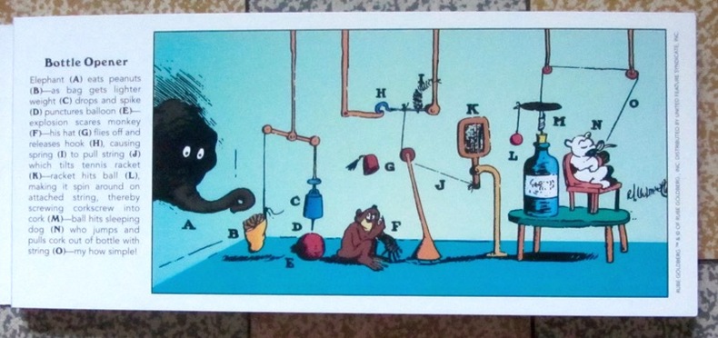
Goldberg Rube:
Inventions! 30 Rube Goldberg Postcards.
Stewart, Tabori & Chang, 1996. 30 cartes postales d'inventions loufoques et hilarantes par Rube Goldberg. Trace d'étiquette de prix au second plat, pour le reste à l'état de neuf.
Référence libraire : 1278
|
|
|
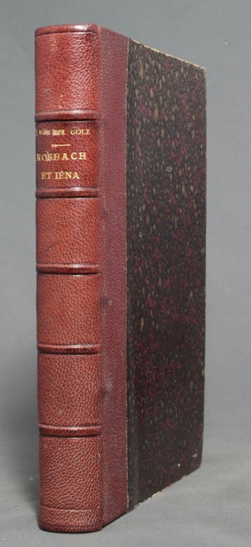
GOLTZ Baron Colmar von der; CHABERT (trad.):
Rosbach & Iéna. Recherches sur l'état physique et intellectuel de l'Armée Prussienne pendant l'époque de transition du XVIIIe au XIXe siècle.
Paris, W. Hinrichsen, 1890. In-8 de VI-486-[2] pages, demi-chagrin bordeaux, dos à 5 nerfs avec titre doré. Bords légèrement frottés.
Référence libraire : 9801
|
|
|
Goldeneye Maps Firm
Cotswolds & Forest of Dean pictorial guide of places to visit & tourist map: 2 miles to 1 inch : the all-purpose map-guide descriptions and . : double sided Goldeneye map-guide series
Goldeneye Maps. Used - Acceptable. Acceptable condition. Map is torn but taped. Maps travel guide England Goldeneye Maps unknown
Référence libraire : SB12D-02033 ISBN : 0946077886 9780946077885
|
|
|
GOLDENEYE Maps
COTSWOLDS & FOREST of DEAN - PICTORIAL GUIDE of PLACES to VISIT and TOURIST MAP; £ 2.50. Scale 2 Miles To 1 Inch
: GOLDENEYE Maps 1989. Soft cover. Near Fine. Map: Near Fine/ $35.14 0946077614 COTSWOLDS & FOREST of DEAN - PICTORIAL GUIDE of PLACES to VISIT and TOURIST MAP; £ 2.50. GOLDENEYE Maps GOLDENEYE Maps 1989 UnStated Edition Tall S/c Folding Map: Near Fine/ Slight Or No Use. Scale 2 Miles To 1 Inch. D/j: None; Case: None. No Odors No Writing No Names No Stains. Description Applies To This Map ONLY. This Map Is Hard To Find Will Be Packaged And Shipped Carefully To Avoid Shipping Damage And Will Make It An Excellent Addition To Your Own Personal Library Collection Or As A Gift. WORLD WIDE SHIPPING AVAILABLE. <br/> <br/> GOLDENEYE Maps paperback
Référence libraire : 013297 ISBN : 0946077614 9780946077618
|
|
|
Goldsborough, Gordon
More Abandoned Manitoba: Rivers, Rails and Ruins
Book is in excellent condition. Binding is solid and square, covers have sharp corners, exterior shows no blemishes, text/interior is clean and free of marking of any kind. 280 pages, loaded with color & b&w photos, maps, charts, tables.
|
|
|
GOMBOUST (Jacques).
Dieppe. La Manche ou Mer Britannique.
Jacques Gomboust. Ingenieur du Roy delineat (circia 1650). Gravure en noir, 365 x 310 mm, bon état.
Référence libraire : 21650

|
|
|
GOMBOUST (d'après Jacques).
ROTHOMAGUS, ROUEN 1655.
Rouen, co-édition Librairie Bertran et Editions Point de Vues, 2003. Portfolio de 15 planches sous chemise cartonnée (42 x 55 cm, 147,5 x 101 cm une fois les 6 planches et le texte assemblés). Parfait état.
Référence libraire : 11990
|
|
|
GOMBOUST (Jacques).
ROTHOMAGUS, ROUEN.
Paris chez l'autheur, Rouen chez Martinot, 1655. En 6 feuilles émargées (38 x 44 cm), (110 x 88 cm une fois assemblé). Quelques minimes manques de papier en haut du plan.
Référence libraire : 16539

|
|
|
GOMES DE MATTOS, Francisco Jaguaribe.
Evolution des idées sur la Physiographie Sud-Américaine. Communication présentée au IIIème Congrès International d'Histoire des Sciences.
Lisboa, 1937 [Extrait du des "Actes, Conférences et Communications du Congrès International d'Histoire des Sciences"]. 4to. mayor; VIII-52 - VII pp., 2 hs. Con un plano plegado entre el texto y un gran mapa potamografico de América del Sur, plegado y contenido en un sobre aparte. Ejemplar con envío autógrafo del autor. Cubiertas originales.

|
|
|
Goncharov/Translated by Tokumitsu Yagawa, Meiji Maps
Educational Theory and School Reform
Not Available 1962. Soft Cover. Fine. The book is in fine condition. Not Available paperback
Référence libraire : 2080502106908338
|
|
|
Goode, James M. & Bruce M. White & Photographer & Floor Plans and Maps by Paul Davidson
Capital Houses Historic Residences of Washington D.C. and Its Environs 1735-1965
Acanthus Press. New. 2015. Hardcover. 0926494910 . FREE UPGRADE to Courier/Priority Shipping Upon Request - IN STOCK AND IMMEDIATELY AVAILABLE FOR SHIPMENT - IN STOCK AND IMMEDIATELY AVAILABLE FOR SHIPMENT - Flawless copy brand new pristine never opened - -- with a bonus offer-- . Acanthus Press hardcover
Référence libraire : 114822 ISBN : 0926494910 9780926494916

|
|
|
Goodwin, Godfrey
Ottoman Turkey: Islamic Architecture
No marks or inscriptions to contents. Very faint creasing to covers, none to spine. A very clean very tight copy with very lightly marked boards, minor rubbing to edges and no bumping to corners. 192pp.

|
|
|
Gordon, Susan
Explore Britain's Villages
No marks or inscriptions. No creasing to covers or to spine. A very clean very tight copy with bright unmarked laminated boards and no bumping to corners. 160pp. The history of change and development in Britain's villages is an intriguing story, described in the introduction to this book. Over 115 villages are featured and beautifully illustrated, from cosy thatched cottages, to the wild and remote hamlets of the Scottish Highlands.

|
|
|
Gordon, William R. maps: Gustafson, Robert J.
THIRD RAILS PANTOGRAPHS & TROLLEY POLES
Rochester NY: William Reed Gordon. Good/NO DUSTJACKET. 1973. . Paperback. Sm 4to. 112 pp. spine faded . William Reed Gordon paperback
Référence libraire : BOOKS340456 ISBN : 091066210X 9780910662109
|
|
|
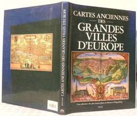
GOSS, John.
Cartes anciennes des grandes villes d’Europe. Une sélection des plus beaux plans de Braun et Hogenberg.
Paris, Solar 1992, 385x290mm, 143pages, reliure d'éditeur sous jaquette. Bel exemplaire.
Référence libraire : 62510
|
|
|
GOSPORT.
Burrows Pointer Guide Map of Gosport including Lee-on-the-Solent & Stokes Bay.
Large folding map printed in red and black on paper measuring 25.0 x 20.0 ins (approx. 63.5 x 51.0 cms) folding in 12 panels to 10.0 x 6.25 ins (approx. 25.5 x 16.0 cms); original printed wrappers, folded as issued, yapped edges, a very good, bright, clean copy. With the original 'pointer' tape mounted on map.'With the aid of the pointer any important street, public building, or any feature of interest may be instantly found'. Copies with the original pointer intact are scarce.

|
|
|
GOSPORT.
Burrows Pointer Guide Map of Gosport including Lee-on-the-Solent & Stokes Bay. Third Edition.
Large folding map printed in red and black on paper measuring 25.0 x 20.0 ins (approx. 63.5 x 51.0 cms) folding in 12 panels to 10.0 x 6.25 ins (approx. 25.5 x 16.0 cms); original printed wrappers, folded as issued, yapped edges, a very good, bright, clean copy. With the original 'pointer' tape mounted on map. 'With the aid of the pointer any important street, public building, or any feature of interest may be instantly found.' Copies with the original pointer intact are scarce.

|
|
|
GOTHARD par Karl LÜÖND et Karl ITEN.
Le Saint-Gothard.Histoire, contes. Richement documenté (planches en couleurs, photos, cartes, figures).
Ed. Ringier 1980. Bel exemplaire relié, reliure pleine toile et jaquette ornées d'éd., gd. in-4, 192 pages.
Référence libraire : AUB-5329
|
|
|
Got Yves:
Petite sérigraphie.
Petite sérigraphie coquine, format carte postale. A l'état de neuf.
Référence libraire : 968

|
|
|
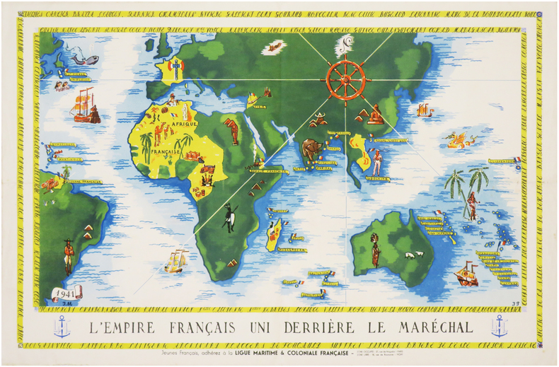
GOUVERNEMENT de VICHY.
[PROPAGANDE SECONDE GUERRE MONDIALE] L'Empire français uni derrière le Maréchal. Jeunes Français, adhérez à la Ligue Maritime & Coloniale Française.
1941. Affiche en couleurs de 305 x 470 mm.
Référence libraire : LBW-7405
|
|
 Recevoir par e-mail
 Télécharger en PDF
 Flux RSS


