|
Lotharingiae tabula generalis in qua Ducatus Lotharingiae et Barri nec non Metensis, Tullensis et Verdunensis Episcopatus. Kolorierte Kupferstichkarte von Homann. Mit Titelkartusche links unten.
48 x 56 cm. *Generalkarte von Lothringen. Blatt 32 aus dem Homann-Atlas auf kräftigem Papier, sehr gut erhalten. Landkarten de
|
|
|
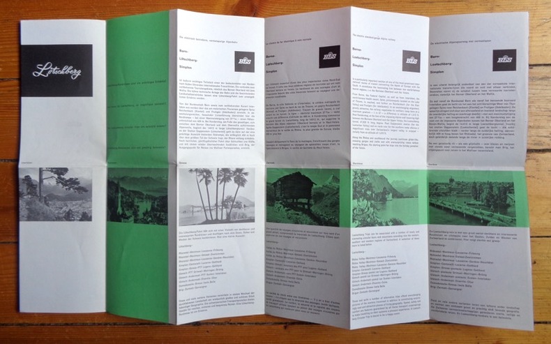
Lötschberg. Excursions et voyages circulaires. Excursions and circular tours - Exkursionen und Rundreisen - Excursies en rondreizen.
Carte dépliante en couleurs, publiée par les BLS (Berne-Loetschberg-Simplon). Photographies en noir et texte en 4 langues au verso. Divers itinéraires en train proposés.
书商的参考编号 : 2604
|
|
|
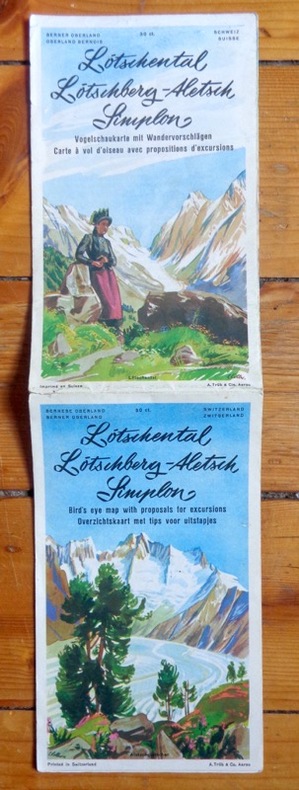
Lötschental, Lötschberg, Aletsch, Simplon. Carte à vol d'oiseau avec propositions d'excursions. Bird's eye map with proposals for excursions. Vogelschaukarte mit Wandervorschlägen. Overzichtskaart met tips voor uitstapjes.
Carte (vous l'aurez compris) dépliante en couleurs. Photographies en noir et texte en 4 langues au verso. Infimes déchirures.
书商的参考编号 : 2654
|
|
|
Madrid. Stadtplan im Maßstab 1: 35.500. Farbige Lithographie.
Leipzig, F. A. Brockhaus, [ca. 1905]. Bildgröße 21 x 14 cm. Unter Feinkartonpassepartout.
书商的参考编号 : 77013

|
|
|
Magdeburg-Altstadt und Werder. Stadtplan im Maßstab 1:14.700. Farblithographie.
Leipzig, F. A. Brockhaus, [ca. 1901. Bildgröße 20,5 x 14 cm. Unter Feinkartonpassepartout.
书商的参考编号 : 76499

|
|
|
Magdeburg. Stadtplan im Maßstab 1:32.000. Farbiger Holzstich.
Leipzig, F. A. Brockhaus, [ca. 1901. Bildgröße 20,5 x 13,5 cm. Unter Feinkartonpassepartout.
书商的参考编号 : 76500

|
|
|
Manchester and Salford City Centres Street Map with Index to Streets
Folded map in good condition, some creasing. No publication date. 50967. eng
|
|
|
Mansfeld: "Comitatus Mansfeldiae Descriptio.auctore Tilemanno Stella Sig". Altkolorierte Kupferstich-Karte von T. Stella bei Janssonius
37 x 43 cm. (Blatt: 42 x 55 cm). *Regionalkarte des Mansfeldischen Gebiets, gedruckt bei Janssonius, schönes Kolorit. - Sauber und sehr gut erhalten. Landkarten de
|
|
|
Mansfeld: "Mansfeldiae Comitatus Descriptio, auctore Tilemanno Stella Sig". Altkolorierte Kupferstich-Karte von T. Stella bei Abraham Ortelius
37 x 43 cm. (Blatt: 42 x 55 cm). *Regionalkarte des Mansfeldischen Gebiets, gedruckt bei Ortelius, schönes Flächenkolorit. - Sauber und sehr gut erhalten. Landkarten de
|
|
|
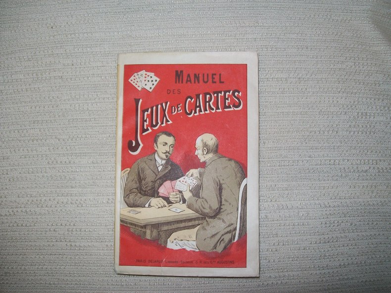
MANUEL des jeux de cartes.
Paris Delarue sd v 1900. In-16 broché couverture illustrée 176pp. Bel exemplaire.
书商的参考编号 : GITb923
|
|
|
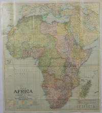
Map of Africa and adjoining portions of Europe and Asia.
Washington D.C.: National Geographic Society. 1922. Large folding printed colour map 77.2 x 69.4 cm small inset map of Cape Verde Island note to the transliteration of place-names reference key to railways caravan routes as well as river systems waterways and deserts legend to Colonial or territorial control original folds slight toning in very good condition. Attractive large-scale map with countries and territories coloured according to the controlling colonial power. . National Geographic Society. unknown
书商的参考编号 : 175918
|
|
|
Map of California and Nevada (1878).
Size: 60 x 49 cm (23 x 16 inch) with wide margins. Leaf: 69 x 51 cm (27 x 20 inch). Printed in red and green colour on thin paper. *Probably the 1878 edition. - "In 1858 William H. Rand, a native of Boston, established a printing office in Chicago and employed as a printer Andrew McNally. By 1868 Rand and McNally formed a partnership which soon acquired a reputation for printing railroad publications. In 1871 they introduced the Rand, McNally Railway Guide. That same year their business was destroyed in the Great Chicago Fire. Rand and McNally opened their new map department in late 1872. In January 1873 it was announced that "the house of Rand, McNally & Co. beg leave to inform their railroad friends and the patrons of the Railway Guide generally, that they have lately made extensive additions to their engraving department, and are now prepared to execute maps using relief-plate engraving [i.e., wax engraving] in the very highest style of the art." With the adoption of the wax engraving process, followed in May 1873 by the employment of a color printing process, the company`s reputation as one of the world`s leading commercial mapmakers was established. A major accomplishment of Rand, McNally was the publication in 1876 of the "New Railroad and County Map of the United States and Canada. Compiled from Latest Government Surveys, and Drawn to an Accurate Scale." That same year, the company used the plates from this map to produce its famous Commercial Atlas and Marketing Guide. This relief map of California and Nevada was included in Rand, McNally & Co.’s Business Atlas published in 1878-9. It shows cities, towns, waterways, and labeled railroad routes" (Historical maps). - Very good condition. Landkarten de
|
|
|
Map of the Catholic churches of London: with double index.
London, Catholic Truth Society, [ca 1940]. rev. Ed. 1 map ; 77 x 51 cm., folded and fastened in covers 13 x 18 cm.
书商的参考编号 : ED3-992

|
|
|
MAPA-GUÍA DE LA NATURALEZA ESPAÑOLA - Madrid 1990 - Muy ilustrado
Madrid, Edit. Incafo, 1990. Numerosas ilustraciones en color. Numerosos mapas en color. 187 p. Folio. Rústica editorial ilustrada. Lomo en espiral. Muy buen ejemplar.
|
|
|
MAPPEMONDE AVEC L'INDICATION DE LA PARTIE DU GLOBE CONNU DES ANCIENS 1822
CARTE COULEUR GÉOGRAPHIQUE COULEUR format 44 cm x 33,5cm ( pliable en 4 parties) Imprimerie de Selves fils, lithographe de l'Université, rue des Lions St Paul n°14 Bel état, document authentique , couleur envoi Export suivis pour l'étranger ( 6,75 €)
书商的参考编号 : CZC-1431

|
|
|
MAPPEMONDE AVEC L'INDICATION DE LA PARTIE DU GLOBE CONNU DES ANCIENS 1822
CARTE COULEUR GÉOGRAPHIQUE COULEUR format 44 cm x 33,5cm ( pliable en 4 parties) Imprimerie de Selves fils, lithographe de l'Université, rue des Lions St Paul n°14 Bel état, document authentique , couleur envoi Export suivis pour l'étranger ( 6,75 €)
书商的参考编号 : CZC-1431
|
|
|
Matta - Iolas
Iolas 0 En feuilles
书商的参考编号 : 015638
|
|
|
Maubeuge - Carte géologique détaillée de la France à l'échelle 1/80 000e - N° 9 - Feuille de Maubeuge.
Paris, Baudry et Cie, 1879; 1 feuille de 114 x 64 cm. découpée en 27 feuilles de 204 x 125 mm. collées sur une toile pliée sous reliure percaline d'éditeur, seule la partie du territoire français est en couleurs avec relevés géologiques, 6 ff. de notice explicative. Bel exemplaire.
书商的参考编号 : 2489
|
|
|
Mecklenburg: "Meklenburg ducatus". Altkolor. Kupferstichkarte von Janssonius.
36 x 48 cm. (Blatt: 47 x 57 cm). *Zeigt das Gebiet von Mecklenburg. Schönes Altkolorit. - Sauber und sehr gut erhalten. Landkarten de
|
|
|
Mecklenburg: "Saxonia inferior et Meklenborg duc". Altkolorierte Kupferstichkarte bei Janssonius.
34 x 44 cm. (Blatt: 45 x 55 cm). *Zeigt das Gebiet von Mecklenburg. - Breitrandig. Landkarten de
|
|
|
Medailles de Louis XIV. Plan de Nanci. Plan de Wesel. Plan de Rees. Plan de Burick. [Kupferstich von 1724, gerahmt].
o.J.
书商的参考编号 : 66484CB
|
|
|
MEMOIRE CONTENANT L'EXPOSE DES DROITS DE LA FRANCE DANS LA QUESTION DES FRONTIERES DE LA GUYANE FRANCAISE ET DU BRESIL SOUMISE A L'ARBITRAGE DU GOUVERNEMENT DE LA CONFEDERATION SUISSE
PHOTOTYPE BERTHAUD , sans date ( 1870 environ ) , recueil de 35 cartes , trés bon état de consevation des cartes de format 30 x 60 cm environ
书商的参考编号 : 2721
|
|
|
Michelin Great Britain Motoring Atlas
32 pages, illustrated, maps. eng
|
|
|
MICHELIN Nationalkarte Frankreich: widerstandsfähiges Papier (MICHELIN Nationalkarten Band 792)
Michelin Vertrieb durch GRÄFE UND UNZER VERLAG GmbH 2011 688 pages 21 4x1 4x10 8cm. 2011. map. 688 pages.
书商的参考编号 : 500269684

|
|
|
Mittleres Engadin Nationalpark.
Zernez, Nationalpark, sans date. Carte au 1:50 000, au format ouvert de 74 x 47,5 cm. En belle condition.
书商的参考编号 : 19312

|
|
|
MOIANÉS - Granollers 1957 - Mapa
Granollers, Editorial Alpina, 1957. Santa María de Oló - Estany - Puig Rodós - Vall de Marfá - El Toll - Collsuspina - Granera. Mapa topográfico excursionista y notas explicativas. Escala 1:25.000. Mapa entelado y plegado. Buen ejemplar.
|
|
|
MONTARTO. Como lo formo. Colomers. Aigües Tortes. Boí - Granollers 1961 - Mapa
Granollers, Edit. Alpina, s/f. Mapa topográfico excursionista. Ascensiones y escaladas. Escala 1: 25.000. Entelado. Muy buen ejemplar.
|
|
|
MONTNEGRE - Granollers c. 1949 - Mapa topográfico
Granollers, Edit. Alpina, s/f. Mapa topográfico excursionista. Escala 1: 25.000. Entelado. Cerrado con funda de tela con cinta. Firma antiguo propietario. Muy buen ejemplar.
|
|
|
MONTNEGRE - Granollers s/f - Mapa
Granollers, Edit. Alpina, s/f. Mapa topográfico excursionista. Escala 1: 25.000. Entelado. Cerrado on funda de tela con cinta. Firma antiguo propietario. Muy buen ejemplar.
|
|
|
Monumental Map of Copenhagen: Summary Guide
One folded colour map, on reverse list of attractions of Copenhhagen. eng
|
|
|
Moret su Loing d'hier à travers la carte postale.
Fontainebleau. Editions "Mise au Poing". 1977. 61 Seiten. Mit zahlreichen Abbildungen. Ill. Originalbroschur. (Etwas fleckig. Private Widmung auf dem Titelblatt). 25x20 cm
书商的参考编号 : 63205

|
|
|
Moscou. 13 + 1 cartes postales de vues anciennes.
14 cartes postales montrant des vues anciennes de Moscou, dont une (dernière image) ne fait pas partie de la même série. Vierges et en belle condition.
书商的参考编号 : 26382

|
|
|
Moscou. Portfolio.
36 vues historiques de Moscou, au format 21 x 15 cm. - Photographies ou reproductions, sous chemise à rabats, un peu défraîchie.
书商的参考编号 : 26140

|
|
|
Motoring Through Czechoslovakia
1 colour map, on reverse general advice about dirving in Czechoslovakia. eng
|
|
|
München. Stadtplan im Maßstab 1: 25.500. Farbige Lithographie.
Leipzig, F. A. Brockhaus, [ca. 1895]. Bildgröße 22 x 27 cm. Unter Feinkartonpassepartout.
书商的参考编号 : 76431

|
|
|
Namenverzeichnis zu Andrees Handatlas. 8. Aufl.
Bielefeld Velhagen & Klasing 1928. . Gering berieben sonst gutes Exemplar Bielefeld, Velhagen & Klasing, 1928. unknown
书商的参考编号 : 62249
|
|
|
Namur: "Mappa Comitatuum Hannoniae, Namurci et Cameraci accuratissime edita". Kupferstichkarte von G. de Lisle (Delisle)
Format: 48 x 66 cm. Landkarten de
|
|
|
National Geographic January 1995
143 pages, illustrated, light creasing to covers, includes articles on Egypt's old kingdom, Gray Reef sharks and New Orleans. eng
|
|
|
Neuchâtel et environs.
Berne, Service topographique fédéral / Atlas topographique de la Suisse, 1930. Carte au 1:25 000, au format ouvert de 94 x 78 cm. En belle condition.
书商的参考编号 : 19310

|
|
|
Neudin, La valeur de vos cartes postales
2000, Neudin, in-8 cartonné de 512 pages, 600 illustrations dont 100 en couleurs. | Etat : Bon état général, dos insolé (Ref.: J5809)
书商的参考编号 : 12231
|
|
|
Neudin, tout sur les cartes postales de collection, 1976
Neudin 1976 1976, Neudin, in-8 broché de 81 pages, couverture illustrée, nombreuses reproductions noir et blanc de cartes postales. | Etat : Etat moyen, couverture très défraichie, déchirure en bas du 1er plat, écriture sur la page de titre (Ref.: ref5603)
书商的参考编号 : 11406
|
|
|
Neue Charte von Engel- Schott und Irrland [Irland]. Landkarte von England, Schottland und Irland. Kupferstich aus Boethius "Kriegs-Helm".
Format: 49 x 56 cm. *Mehrfach gefaltet. Oberrand mit kleiner (hinterlegter) Fehlstelle (ca. 4 x 2,5 cm). Landkarten de
|
|
|
Neue Landeskarten der Schweiz. Studienblatt des Schweizer Alpenklub. & Militär. Vorarbeiten für Neue Landeskarten der Schweiz - Studienblatt. Zus. 2 Karten.
Bern, Eidg. Landestopographie, 1932, in-8vo, pliée dépl. 72x45 cm, 2 Karten zus.
书商的参考编号 : 130203aaf
|
|
|
Neuer Hansa-Plan der Hansestadt Hamburg mit Straßenverzeichnis. Ausgabe 1946. 776.-800. Tsd.
Hamburg, Christian Wegner, 1946. Mehrfach gefalt. farb. Faltplan im Maßstab 1:15 000. Kartengröße: 55,5 x 74,5 cm. Blattgröße: 56,5 x 75,5 cm; Faltmaß: 19 x 10 cm.
书商的参考编号 : 87956

|
|
|
Neuer Hansa-Plan der Hansestadt Hamburg von Blankenese bis Wandsbek. [Mittlere Ausgabe 1939/1940]. 731.-755 Tsd. Neu bearbeitet.
Hamburg, Hansa-Verlag Heinz Thiele, 1939. 1 farb. Falt-Plan im Maßstab 1:15 000, verso 4 s-w. Beikarten. Blattgröße 70 x 82 cm, Deckel 19 cm. Mit 32 S. Register. Illustr. OBrosch.
书商的参考编号 : 87955
|
|
|
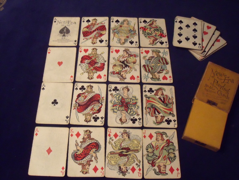
New Era n°46
52 cartes - joker manquant - Portrait de création originale de style" Art Nouveau" - 1896 - Fabricant: United Playing cards - Cincinnati - Jeu légèrement usé - boite d'origine complète un peu ternie , mais complète avec son timbre de scellement .
书商的参考编号 : 9631896
|
|
|
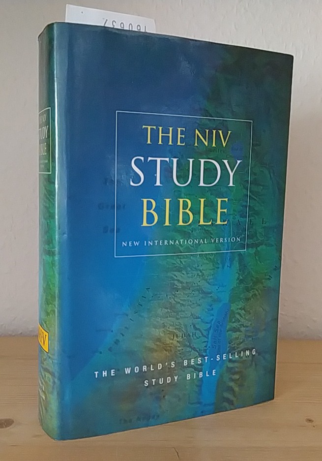
New International Version Study Bible. With Study Notes and References, Concordance and Maps.
London, Sydney, Auckland: Hodder & Stoughton 2000. XVIII, 2171 Seiten. Dünndruck. Mit 11 farbigen Kartenabbildungen im Anhang. Gr. 8° (22,5-25 cm). Orig.-Kunstlederband mit goldgeprägtem Titel auf Deckel und Rücken sowie mit Orig.-Schutzumschlag und Lesebändchen. [Hardcover / fest gebunden].
书商的参考编号 : 160637
|
|
|
Newstatt an der Aysch (Neustadt an der Aisch). Grundrißplan mit Befestigungsanlagen. Kupferstich von Merian
16,5 x 28,5 cm. Unter Passepartout und gerahmt. Landkarten de
|
|
|
Nieuwe kaart van de Opper en Neder RhynseKreits nevens het Hertogdom Lotharingen. Original-Kupferstich, unkoloriert.
Amsterdam, Isaak Tirion, [ca. 1750]. Bildgröße: 28,4 x 33,7 cm. Unter hellgrauem Passepartout (39,3 x 44,2 cm).
书商的参考编号 : 81146

|
|
|
NOARRE - Madrid 1948 - Mapa
Madrid, Dirección General del Instituto Geográfico y Catastral, 1948. 2ª edición. Mapa publicado por sectores (sector 150). Escala 1:50.000. 56x76 cms. Mapa entelado y plegado. Buen ejemplar.
|
|
 ?????????
 ?????PDF???
 RSS feed


