|
Dempsey, Hugh A.
Glenbow, November (Nov.) - December (Dec.), 1971, Vol. 4, No. 6 - Robert Rundle Papers
8 pages. Features: Robert Rundle Papers; Rare 1841 Map of Banff Area; New Exhibition of instruments and machines which were used to titillate, entertain, and amuse; Annual Report. Black and white reproductions of archival photos. Average wear. Unmarked. A sound copy. Book

|
|
|
Dempster Thomas (Scozia, a Cliftbog, presso Aberdeen, 1579 -Bologna, 1625)
Descriptio Urbis Romae, à Romulo conditae.
Pianta di Roma antica a proiezione verticale con alzato. Tra i pochi monumenti riprodotti alcuni sono recenti, come il torrione di Niccolò V in Vaticano, la basilica di S. Paolo, la villa di Giulio III (costruita fra 1551-1553). Orientata con il Nord a sinistra.Questa pianta originariamente è inserita, ripiegata, da Bernardo Gamucci nei suoi “Libri quattro dell’antichità della città di Roma raccolte sotto brevità da diversi antichi et moderni scrittori”, prima edizione apparsa a Venezia, appresso Varisco & Compagni, nel 1565.La stessa pianta, con vari errori nei toponimi, con l’aggiunta della cornice decorativa e del testo in latino, si trova inserita anche nell’aggiornamento dell’opera di Johannes Rosinus (Johann Rossfeld) “Antiquitatum Romanorum corpus absolutissimum…” (I edizione 1585) edita da Thomas Dempster, stampata a Ginevra nel 1612 a spese di Samuel Chouët, che conobbe varie edizioni (1613, 1620, 1632, 1645, 1662, 1701, 1743). La pianta edita dal Dempster viene realizzata mediante un nuovo intaglio in legno, arricchito da una bordura ornamentale di stile nordico.Silografia, tracce delle pieghe editoriali, in ottimo stato di conservazione. Rara. Map of ancient Rome; vertical projection with elevation. Among the few monuments reproduced some are recent, such as the tower of Niccolò V in the Vatican, the basilica of S. Paolo, the villa of Giulio III (built between 1551-1553). Oriented with North to the left. This map is originally inserted, folded, by Bernardo Gamucci in his "Libri quattro dell’antichità della città di Roma raccolte sotto brevità da diversi antichi et moderni scrittori”, first edition published in Venice, Varisco & Compagni, in 1565. The same map, with various errors in the toponyms, with the addition of the decorative frame and the Latin text, is also included in the update of the work by Johannes Rosinus (Johann Rossfeld) "Antiquitatum Romanorum corpus absolutissimum ..." (1st edition 1585) published by Thomas Dempster, printed in Geneva in 1612 by Samuel Chouët, who went through various editions (1613, 1620, 1632, 1645, 1662, 1701, 1743). The map printed by Dempster is created by a new wood block, enriched by an ornamental border of Nordic style. Woodcut, traces of editorial folds, in excellent condition. Rare. cfr. Frutaz XVIII, Tav. 35; Scaccia Scarafoni, p. 26, n. 16.

|
|
|
DENDIEVEL (Emile).
Notre Dame de Paris.
1875. 87 x 60 cm, monté sur carton et entouré d'un passe-partout sur lequel sont remontés la date, le nom de l'auteur et le titre.
Referentie van de boekhandelaar : LBW-7465

|
|
|
DENIS (Louis) & PASQUIER (Jacques-Jean).
[FORÊT de FONTAINEBLEAU] Carte de la forest de Fontainebleau et de ses environs divisée en ses huit gardes.
Paris, Denis et Pasquier, 1786. En 18 sections montées sur toile et pliées, formant une carte de 540 x 685 mm.
Referentie van de boekhandelaar : LBW-3219

|
|
|
DENIS Fernand; FAMIN M. C:
Brésil - Colombie et Guyanes.
Paris, Firmin Didot frères, 1837. In-8 de [4]-384-[2] et 32 pages, demi-veau glacé prune, dos à nerfs orné de filets dorés, tomaison de la collection au dos.
Referentie van de boekhandelaar : 15830
|
|
|
DENIS, Louis - BRUÉ, H.
Atlas topographique de l'ancienne province de Normandie et pays limitrophes, dédié en 1770 à M. Thiroux de Crosne. Revu, corrigé et augmenté en 1817, par H. Brué Géographe de S. A. R. Monsieur.
1 17 ff. de Titre (à double page) Paris, J. Goujon, 1817, in-folio de 17 feuilles, dont le Titre, montées sur onglets, reliure moderne demi-basane tabac glacée, titre or en long, gardes de papier marbré moderne, couvertures conservées, grande pièce de titre ornée contrecollée à la première de couverture ; fine restauration angulaire au titre, quelques pâles piqûres marginales à la planche 10.
Referentie van de boekhandelaar : 10508
|
|
|
Denison, Allen T.; Huntington, Wallace K.
Victorian Architecture of Port Townsend Washington
Book is in excellent condition. Binding is solid and square, covers have sharp corners, exterior shows no blemishes, text/interior is clean and free of marking of any kind. Dust jacket has numerous small tears at edges, now wrapped in clear protective cover. 176 pages with large b&w photos throughout, mostly exteriors, some interior, many detail shots, of commercial and public buildings, churches, residences, and misc. structures, maps, drawings; 49 individual structures featured with photos and a detailed description. Buildings include the: Fowler building, Bartlett, Waterman and katz, C.F. Clapp, Franklin House, Capt. Tibbals, Fowler-Caines, Hastings, N.D. Hill, James and Hastings, Terry, Siebenbaum, etc.
|
|
|
Dennis G Casebier; Road Log By Neal Johns; Maps By R. N. "Bob" Martin; Illustrations By Ted Jensen (D. Ratt)
Guide to the East Mojave Heritage Trail: Fenner to Needles Tales of the Mojave Road
Essex Ca: Tales Of The Mojave Road Publishing Company 1990. 1st Edition 1st Printing. Hardcover. Near Fine. 303 Pp. First Printing. Gold Cloth Stamped In Brown. First Printing. Very Near Fine. <br/> <br/> Tales Of The Mojave Road Publishing Company hardcover
Referentie van de boekhandelaar : 045014 ISBN : 0914224190 9780914224198
|
|
|
Dennis G Casebier; Neal Johns; Maps By Bob Martin; Illustrations By Ted Jensen; Etc.
Guide To The East Mojave Heritage Trail: Ivanpah To Rocky Ridge
Norco: Tales Of The Mojave Road Publishing Company 1988. 1st Edition 1st Printing. Hardcover. Near Fine. Maps Photographs Cartoons. 305 Pp. Red Boards Gilt. First Printing. Very Near Fine. <br/> <br/> Tales Of The Mojave Road Publishing Company hardcover
Referentie van de boekhandelaar : 045015 ISBN : 0914224131 9780914224136
|
|
|
Denoyer-Geppert social science maps, A19
Lines of Transportation. map
Chicago: Denoyer-Geppert Social Science Maps 1963. Book. Very Good. No Binding. 1 map : color ; 69 x 105 cm folded to 42 x 28 cm. showing transport routes America wide.main lines and secondary routes divided in sections and laid on canvas eyelets for hanging very good conditionScale ca. 1:4500000 Denoyer-Geppert social science maps A19. Denoyer-Geppert Social Science Maps unknown
Referentie van de boekhandelaar : 1125558442
|
|
|
Denson John editor in chief; Bacheller Martin A. editor in chief for maps
The Five Worlds of Our Lives: Ingredients and Results of War and Revolution
U.S.A. And Canada simultaneously: Newsweek Inc. and C.S. Hammond & Co. Inc. 1961 319 numbered pp; HB. Pages: clean bright tight speckled edgestain; a.e. lt tanned mildly cocked. Cover: brown padded leatherette gilt ornamentation front gilt titles spine; v lt shelfwear extrems slightly worn back b.e. bumped. An evaluation of "the deadly-sometimes hopeful-shape of things man hath wrought." Newsweek, Inc. and C.S. Hammond & Co., Inc. hardcover
Referentie van de boekhandelaar : 032779
|
|
|
Denton, V.L.
The Far West Coast
297 pages including bibliography and index. "...into the heart of the vast Pacific the tale shall lead us, where men and ships are dwarfed to veriest specks which crawl laboriously a little space and then are lost to view." - from Introduction. Subjects include: the Straits of Anian; How the Russians crossed Siberia; Vitus Bering; James Cook; John Meares; George Vancouver; Quadra; and more. With 12 illustrations and 7 maps. Binding intact. Soiled but not overly so. Moderate lean to spine. Decorated biege boards. Gift greetings upon front endpaper else unmarked. Remains a decent copy. Book
|
|
|
DENTRECASTEAUX (Antoine-Raymond-Joseph de Bruny) , ROSSEL (Édouard de)
Voyage de Dentrecasteaux, envoyé à la recherche de La Pérouse. Publié par ordre de sa Majesté l’Empereur et Roi, sous le ministère de S. E. le vice-amiral Decrès, comte de l’Empire. Rédigé par M. de (Édouard de) Rossel, ancien capitaine de vaisseau.
A Paris, Dépôt général des Cartes et Plans de la Marine et des Colonies, 1807 et De L’Imprimerie Impériale, 1808 RARE ENSEMBLE COMPLET en 3 volumes TEXTE ; 2 forts vol. in-4° ; (2)-LVI-704 pp.-32 pl. h.-t. repliées in-fine (I-XXXII)/(2)-VIII-692 pp.-1 pl. h.-t. Repliée sur papier bleuté , relié demi cuir , dos lisse avec titre et tomaison , tranches mouchetées , mouillure angulaire sur 7 planches, petites rousseurs sur les planches . ATLAS ; 1 volume grand in-folio (560x445) ,page de titre-1 fnch. (Table )-39 cartes et vues h.-t. , dont 29 à double page ,dressées par l'ingénieur hydrographe C. F. Beautemps Beaupré et gravées sur cuivre par E. Collin , relié demi cuir , dos lisse ,cachets répétés , petites rousseurs .
Referentie van de boekhandelaar : PHO-1

|
|
|
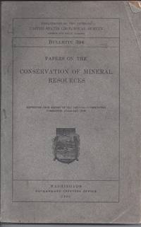
Department of the Interior; Photographs, Diagrams, Maps and Charts [Illustrator]
Papers on the Conservation of Mineral Resources: United States Geological Survey Bulletin 394
Government Printing Office 1909-01-01. Paperback. Good. 1909 Soft Cover Edition. Wear to top and bottom edge of spine. Pages are tanned but are unmarked. Rubbing to back cover edge. Government Printing Office paperback
Referentie van de boekhandelaar : R9-1-10-21-30
|
|
|
Department of State; Administrative Subdivisions of Japan.
[ATLAS]. APPENDIX TO "ADMINISTRATIVE SUBDIVISIONS OF JAPAN". Department of State Publication 2749, Far Eastern Series 19.
Atlas. 47 large color folding maps. XLib. A few maps have XLib stamps in margins, otherwise maps very clean. Large folio. Spiral bound. Original stiff printed wraps, some wear. WWII 2
|
|
|
DEPOT de la GUERRE.
[PROVENCE] Marseille.
Paris, 1875. 525 x 820 mm.
Referentie van de boekhandelaar : LBW0395d
|
|
|
Depot des cartes et plans de la Marine:
Antilles - Ile de Culebra ou du Passage
Paris 1873. French naval chart sheet 3256 sheet size 72.5 x 105 cm engraved by Delamare black and white with coastal profiles in the lower part of the chart centrefold one or two marginal nicks and tears blank verso. This detailed chart of Isla Culebra now an island-municipality of Puerto Rico was derived from British Admiralty surveys. With no permmanent population for centuries the island was settled by the Spanish in the 1880s and ceded to the United States after the Spanish-American War. Map unknown
Referentie van de boekhandelaar : 9508
|
|
|
Depot des cartes et plans de la Marine:
Antilles - Ilde de la Grenade
Paris 1873. French naval chart sheet 3273 sheet size 105.5 x 72 cm engraved by Nyon black and white centrefold one or two marginal nicks and tears blank verso. This detailed chart of Grenada was derived from British Admiralty surveys. Map unknown
Referentie van de boekhandelaar : 9509
|
|
|
Depot des cartes et plans de la Marine:
Antilles - Ile de Montserrat
Paris 1873. French naval chart sheet 3119 50 x33 cm black and white blank verso. Chart of the island of Montserrat in the British West Indies featuring coastal profiles dominated by the Soufrière Hills volcano and an inset of Plymouth the former capital of the island which was destroyed in the volcanic eruptions of the mid 1990s. Map unknown
Referentie van de boekhandelaar : 8667
|
|
|
Depot des cartes et plans de la Marine:
Japón - Cote Est de Yesso - Baie Akishi
Paris 1873. French naval chart sheet 3245 sheet size 51 x 36 cm engraved by Régnier after a British Admiralty chart of 1871 black and white blank verso. Akkeshi Bay located in Kushiro Subprefecture on the east coast of Hokkaido the most northerly of the main islands of Japan. Map unknown
Referentie van de boekhandelaar : 8669
|
|
|
Depot des cartes et plans de la Marine:
Mer Méditerranée - Port de Smyrne
Paris 1920. French naval chart 63 x 91.5 cms black and white with beacons highlighted in yellow insets of Port dAbri the inner harbour at modern day Izmir and two coastal profiles slightly dusty lower margin one or two closed marginal tears blank verso. Engraved in 1866 after British charts by Copeland and Spratt this example of the map was printed in September 1920 during the Greek occupation of the Zone of Smyrna part of the territory awarded to Greece at the expense of the Ottoman Empire by the Allied powers after the Great War. Smyrna became an important base for Greek forces during the resulting Greco-Turkish War of 1919-1922 and in the bloody aftermath of the Greek withdrawal half the city was razed in the Great Fire of Smyrna also known as the Smyrna Catastrophe. Map unknown
Referentie van de boekhandelaar : 8575
|
|
|
Depot des cartes et plans de la Marine:
Océan Pacifique - Ile Juan Fernandez - Mouillage de San Juan Bautista
Paris 1872. French naval chart sheet 3068 sheet size 36 x 53 cm engraved by Régnier black and white blank verso. The anchorage at San Juan Bautista located on Cumberland Bay Robinson Crusoe Island; the main settlement in the Juan Fernández Islands off the coast of Chile. Map unknown
Referentie van de boekhandelaar : 8668
|
|
|
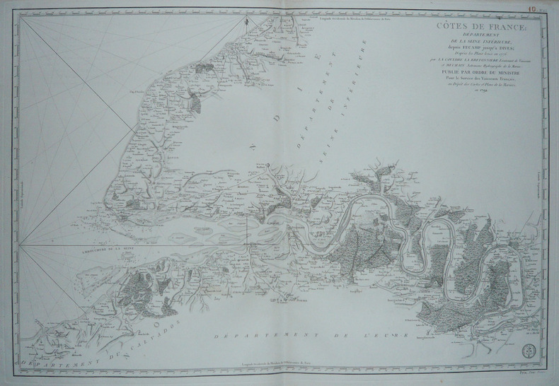
DEPOT des CARTES et PLANS de la MARINE.
[HAUTE-NORMANDIE] Côtes de France : Département de la Seine Inférieure, depuis Fécamp jusqu'à Dives.
Paris, 1792. 585 x 862 mm.
Referentie van de boekhandelaar : LBW-1732
|
|
|
DEPOT des CARTES et PLANS de la MARINE.
[INDONESIE] Carte du détroit de Macassar.
Paris, 1864. 915 x 620 mm.
Referentie van de boekhandelaar : LBW03578

|
|
|
DEPOT des CARTES et PLANS de la MARINE.
[PATAGONIE] Havre Grappler (Côte occidentale de Patagonie).
Paris, 1870-1880. 474 x 314 mm.
Referentie van de boekhandelaar : LBW007a6

|
|
|
DEPOT des CARTES et PLANS de la MARINE.
[PATAGONIE] Plan de la baie de l'Isthme (Isthmus Bay) (Côte occidentale de Patagonie).
Paris, 1869-1870. 641 x 468 mm.
Referentie van de boekhandelaar : LBW007a9
|
|
|
DEPOT des CARTES et PLANS de la MARINE.
[PATAGONIE] Plan du havre Eden (Côte occidentale de Patagonie).
Paris, 1869-1881. 640 x 470 mm.
Referentie van de boekhandelaar : LBW007a7
|
|
|
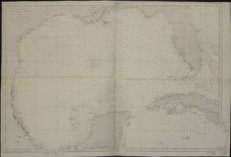
DEPOT des CARTES et PLANS de la MARINE.
[TEXAS et FLORIDE] Carte générale du golfe du Mexique dressée d'après les travaux américains, anglais et français les plus récents.
Paris, 1865-1882. 635 x 945 mm.
Referentie van de boekhandelaar : LBW02e51
|
|
|
DEPOT des CARTES et PLANS de la MARINE.
[VENEZUELA et GUYANE] Amérique méridionale. Côtes du Vénézuéla et des Guyanes. Du golfe de Paria au cap d'Orange.
Paris, 1871-1881. 623 x 918 mm.
Referentie van de boekhandelaar : LBW03956

|
|
|
DEPOT des CARTES et PLANS de la MARINE.
[YEMEN] Côte d'Arabie. Aden et baies adjacentes.
Paris, 1872. 611 x 892 mm.
Referentie van de boekhandelaar : LBW-2421

|
|
|
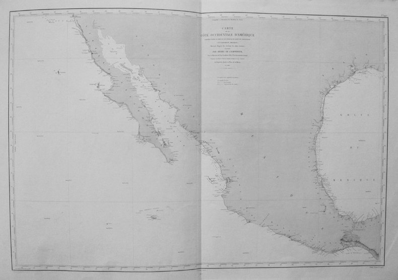
DEPOT des CARTES et PLANS de la MARINE;
[CALIFORNIE/TEXAS/MEXIQUE] Carte de la côte occidentale d'Amérique comprise entre le port de San Diego et le golfe de Tehuantepec (Vlle Californie, Mexique).
Paris 1863-1877 606 x 906 mm.
Referentie van de boekhandelaar : LBW0359e
|
|
|
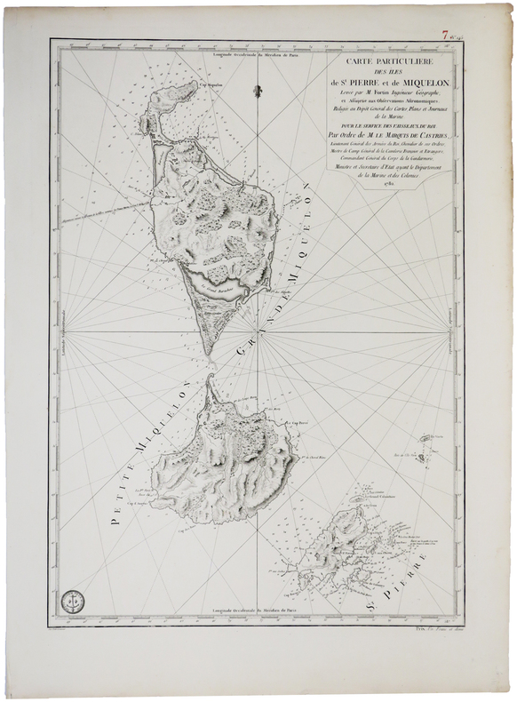
DEPOT GENERAL des CARTES PLANS et JOURNAUX de la MARINE.
[SAINT-PIERRE ET MIQUELON] Carte particulière des îles de St. Pierre et de Miquelon.
[Paris], Dépôt Général des Cartes, Plans et Journeaux de la Marine, 1782. 580 x 412 mm.
Referentie van de boekhandelaar : LBW0393e
|
|
|
DEPOT-GENERAL DE LA MARINE.
[PAYS BASQUE] Carte réduite des côtes de France, depuis le bassin d'Arcachon jusqu'à Fontarabie, et d'Espagne jusqu'au cap Machichaco.
1818. 598 x 900 mm.
Referentie van de boekhandelaar : LBW03579
|
|
|
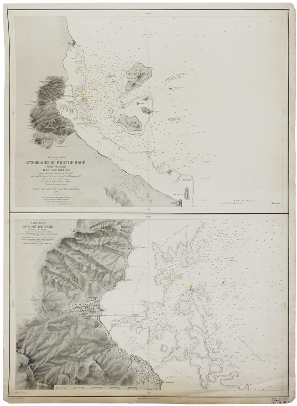
DEPOT-GENERAL DE LA MARINE.
[SEYCHELLES] Mer des Indes. Atterrages du port de Mahé, Port Victoria, Iles Seychelles. - Barachois du port de Mahé, Port Victoria.
Paris, 1880. 630 x 463 mm.
Referentie van de boekhandelaar : LBW-2419
|
|
|
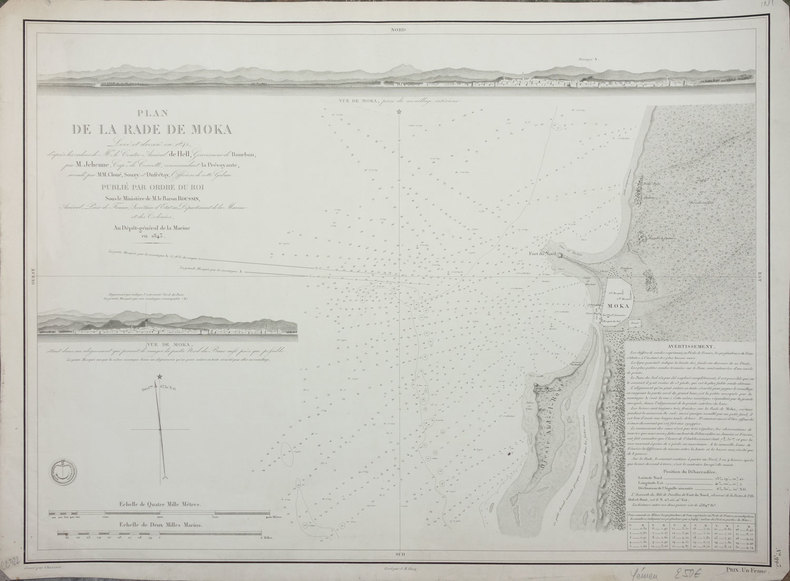
DEPOT-GENERAL DE LA MARINE.
[YEMEN] Plan de la rade de Moka.
Paris, 1843. 427 x 577 mm.
Referentie van de boekhandelaar : LBW-2412
|
|
|
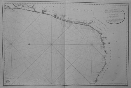
DEPOT-GENERAL DE LA MARINE;
[BRESIL] Carte réduite des attérages du port de Maranham situés à la côte du Brésil.
Paris 1826 613 x 913 mm.
Referentie van de boekhandelaar : LBW03952
|
|
|
Depping (G.-B.)
Les jeunes voyageurs en France.
1824 Etienne Ledoux Libraire Editeur, Paris, 1824. 6 volumes in-12, reliure plein veau marbré, dos lisse orné de frises et de dentelles en queue, pièces de titre et tomaison maroquin rouge, plats ornés de filets et dentelles en encadrement, dentelles intérieures et tranches jaspées, orné de 100 cartes coloriées ou vues de ville en noir hors-texte par A.M. Perrot, gravées par Blanchard, 279, 263, 303, 241, 246 et 238 pages. Rousseurs, néanmoins bel exemplaire.
Referentie van de boekhandelaar : 2750
|
|
|
DERICHSWEILER, W. / HEIM, Alb.:
Führer durch das Medelser=Gebirge. Das Gebiet der Medelserhütte, der Sektion Uto des Schweizer Alpen Club.
Frauenfeld, Huber, 1910, in-8vo, V + 2 Bl. + 84 S. mit 1 Bildnis, 26 Bergzeichnungen, 5 geologischen Profilen und 3 Kartenskizzen. Original-Leinenband.
Referentie van de boekhandelaar : 42174aaf
|
|
|
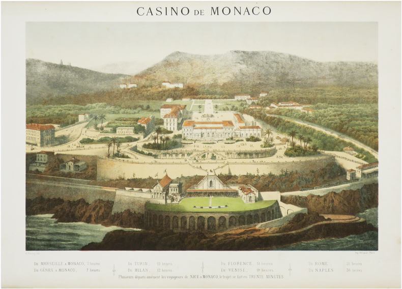
DEROY (Auguste-Victor).
[MONACO] Casino de Monaco [et] Grands Magasins de la Paix. Première Maison du monde. Paris.
Paris, Becquet, [circa 1872]. 322 x 418 mm et 316 x 383 mm.
Referentie van de boekhandelaar : LBW-7570
|
|
|
DEROY (Isidore).
[LE HAVRE] Le Hâvre. Vue prise de la mer - El Avre de Gracia. Vista tomada del mar.
Paris et New-York, L. Turgis J.ne, [circa 1860]. 380 x 498 mm.
Referentie van de boekhandelaar : LBW-7314

|
|
|
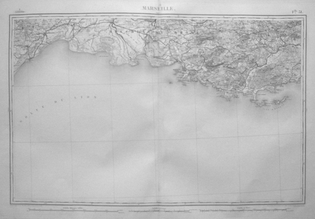
DEROY (Isidore).
[MARSEILLE] Vue générale de Marseille - Vista general de Marsella.
Paris et New-York, L. Turgis J.ne, [vers 1870]. 375 x 497 mm.
Referentie van de boekhandelaar : LBW-7618

|
|
|
DEROY (Isidore);
Florence. Palais Pitti - Firenze. Palazzo Pitti.
Paris Jeannin circa 1850 161 x 242 mm.
Referentie van de boekhandelaar : LBW02e71
|
|
|
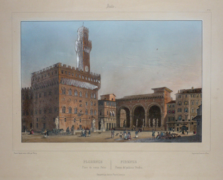
DEROY (Isidore);
Florence. Place du Vieux Palais - Firenze. Piazza del Palazzo Vecchio.
Paris Jeannin circa 1850 164 x 242 mm.
Referentie van de boekhandelaar : LBW02e70
|
|
|
DEROY (Isidore);
Rome. Le Forum - Roma. Foro romano.
Paris Jeannin circa 1850 230 x 265 mm.
Referentie van de boekhandelaar : LBW00274
|
|
|
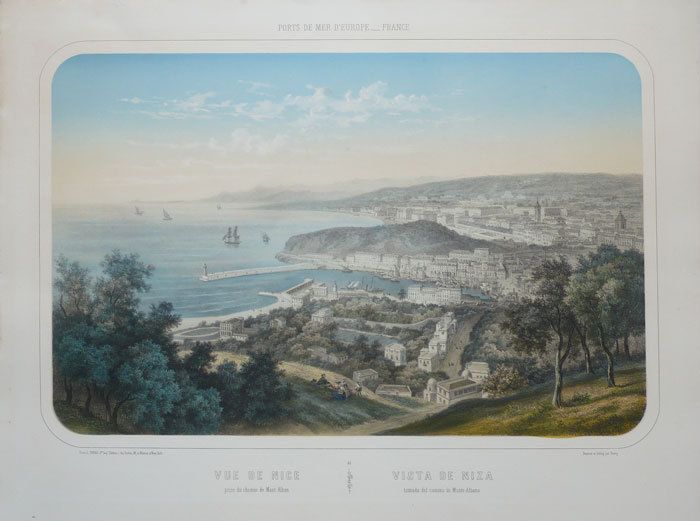
DEROY (Isidore);
Vue de Nice prise du chemin de Mont-Alban - Vista de Niza tomada del camino de Monte-Albano.
Paris L. Turgis circa 1850 380 x 501 mm.
Referentie van de boekhandelaar : LBW-1139
|
|
|
DEROY (Isidore-Laurent).
[AVIGNON] France en miniature. Avignon. Vue de la Place de l'Horloge, du Théâtre et de l'Hôtel de Ville.
Paris, Morier, [1858]. 153 x 201 mm.
Referentie van de boekhandelaar : LBW-8696

|
|
|
DEROY (Isidore-Laurent).
[AVIGNON] France en miniature. Avignon. Vue de la Cathédrale et du Calvaire.
Paris, Morier, [1858]. 155 x 218 mm.
Referentie van de boekhandelaar : LBW-8707

|
|
|
DEROY (Isidore-Laurent).
[BEAUCAIRE & TARASCON] France en miniature. Beaucaire et Tarascon.
Paris, Morier, [1858]. 153 x 204 mm.
Referentie van de boekhandelaar : LBW-8703

|
|
|
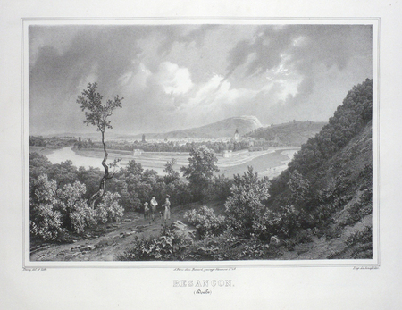
DEROY;
BESANCON (Doubs).
Paris Benard circa 1850 231 x 298 mm.
Referentie van de boekhandelaar : LBW03d57
|
|
|
DEROY;
BOURGES (Cher).
Paris Benard circa 1850 218 x 289 mm.
Referentie van de boekhandelaar : LBW03d64

|
|
 De zoekresultaten per email ontvangen
 Zoekresultaten downloaden als PDF
 RSS feed


