|
FONTENAY (Harold de)
Notice sur un jeu de cartes inédit du temps de Louis XII.
Paris, Lainé et Havard, 1865 in-8, 23 pp., 2 planches de cartes à jouer en couleurs, sans couverture. Envoi.
Referenz des Buchhändlers : 179852
|
|
|
Fonseca, Isabel ; maps, David Lindroth
Bury Me Standing: The Gypsies and Their Journey
Vintage Books New York 1996 1996. 1st Edition 3rd Printing. Soft cover. Fine. First Vintage Departures edition ; 3rd printing ; 322 pages : illustrations maps ; 21 cm ; ISBN 9780679737438 9780099740216 9780679406785 067973743X 0099740214 0679406786 ; 3OCLC 5840728 ; photographic stiff paper wrappers ; Contents: Out of the mouth of Papusza : A cautionary tale --The Dukas of Albania -- Kinostudio -- Everybody sees only his own dish -- Women's work -- Learning to speak -- Into town -- The zoo -- To Mbrostar -- Hindupen -- Antoinette Emilia and Elena -- The least obedient people in the world ; Emilian of Bolintin -- Deal ; A social problem -- Slavery -- No place to go -- The other side -- Zigeuner chips -- The devouring -- The temptation to exist ; A masterful work of personal reportage this volume is also a vibrant portrait of a mysterious people and an essential document of a disappearing culture. Fabled feared romanticized and reviled the Gypsies-or Roma-are among the least understood people on earth. Their culture remains largely obscure but in Isabel Fonseca they have found an eloquent witness. In Bury Me Standing alongside unforgettable portraits of individuals-the poet the politician the child prostitute-Fonseca offers sharp insights into the humor language wisdom and taboos of the Roma. She traces their exodus out of India 1000 years ago and their astonishing history of persecution: enslaved by the princes of medieval Romania; massacred by the Nazis; forcibly assimilated by the communist regimes; evicted from their settlements in Eastern Europe and most recently in Western Europe as well. Whether as handy scapegoats or figments of the romantic imagination the Gypsies have always been with us-but never before have they been brought so vividly to life. ; Includes fifty black and white photos.--Source: Publisher ; FINE <br/> <br/> Vintage Books, New York, 1996 paperback
Referenz des Buchhändlers : 008866 ISBN : 067973743x 9780679737438

|
|
|
Foote Shelby; Maps Illustrator
The Civil War: A Narrative: Five Forks to Appomattox: Victory and Defeat # 9 in series
Random House 1974-01-01. Hardcover. New. In shrink wrap. Looks like an interesting title! Random House hardcover
Referenz des Buchhändlers : Q-030729031x ISBN : 030729031X 9780307290311

|
|
|
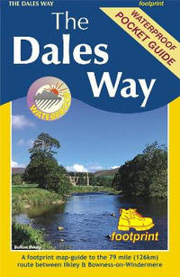
Footprint Maps
The Dales Way: A footprint map-guide to the 79 mile route between Ilkley & Bowness-on-Windermere
Sheet map folded. New. The Dales Way is a 79 mile 127km long distance trail in the north of England running between Ilkley in North Yorkshire and Bowness-on-Windermere in Cumbria. unknown
Referenz des Buchhändlers : A9781916002937 ISBN : 1916002935 9781916002937
|
|
|
Footprint Maps
The Orkney Islands
Sheet map folded. New. New Book; Fast Shipping from UK; Not signed; Not First Edition; This map is the perfect companion to take for exploring the Shetland Islands. It is packed with lots of information on where to find the best that this group of islands has to offer visitors. unknown
Referenz des Buchhändlers : ria9781871149913_inp ISBN : 1871149916 9781871149913

|
|
|
Footprint Maps
The Orkney Islands: Visitor Map
Sheet map folded. New. This map is the perfect companion to take for exploring the Shetland Islands. It is packed with lots of information on where to find the best that this group of islands has to offer visitors. unknown
Referenz des Buchhändlers : A9781871149913 ISBN : 1871149916 9781871149913

|
|
|
Footprint maps
The Shetland Islands: Visitor Map
Sheet map folded. New. This map is the perfect companion to take for exploring the Shetland Islands. It is packed with lots of information on where to find the best that this group of islands has to offer visitors. unknown
Referenz des Buchhändlers : A9781871149920 ISBN : 1871149924 9781871149920

|
|
|
Fort Esteve:
18 cartes neuves - Tintin F. Miro.
1000 editions. Carte double au format fermé de 12,5 x 17 cm. (les cartes ne le sont pas encore - pliées donc - puisque flambant neuves).
Referenz des Buchhändlers : 22507

|
|
|
Forissier Béatrix
30 années d'élégance à travers la carte postale 1900-1930.
Les éditions de l'amateur. 1978. In-4. Relié. Bon état, Couv. convenable, Dos satisfaisant, Intérieur frais. 190 pages - nombreuses illustrations en couleurs et en noir et blanc dans le texte - en supplément une lettre dactylographiée non signée de l'éditeur + carte de visite de l'auteur avec hommage.. . . . Classification Dewey : 741.68-Illustrations des cartes postales
Referenz des Buchhändlers : R320162809

|
|
|
FORISSIER Béatrix
30 années d'élégance à travers la carte postale (1900-1930).
Les Editions de l'Amateur, 1978. 21 x 30, 190 pp., très nombreuses illustrations en N/B, reliure d'édition pleine toile, très bon état.
Referenz des Buchhändlers : 79281
|
|
|
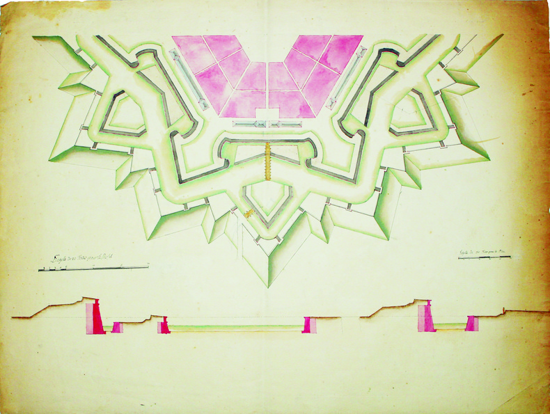
FORTIFICATIONS. MANUSCRIT.
[Plan d'un d'un demi hexagone régulier].
[circa 1750]. 494 x 648 mm.
Referenz des Buchhändlers : LBW-4162
|
|
|
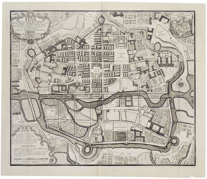
FORESTIER (F.).
[RENNES] Plan de la ville de Rennes levé par F. Forestier après l'incendie arivée le 22 xbre 1720, sur lequel ont esté formé les projets tant du Sr. Robelin Directeur des fortifications de cette province, et signé de luy, que du Sr. Gabriel Contrôleur Général des Bâtiments du Roy.
Rennes, Guillaume Vatar, 1726. 510 x 611 mm.
Referenz des Buchhändlers : LBW00292
|
|
|
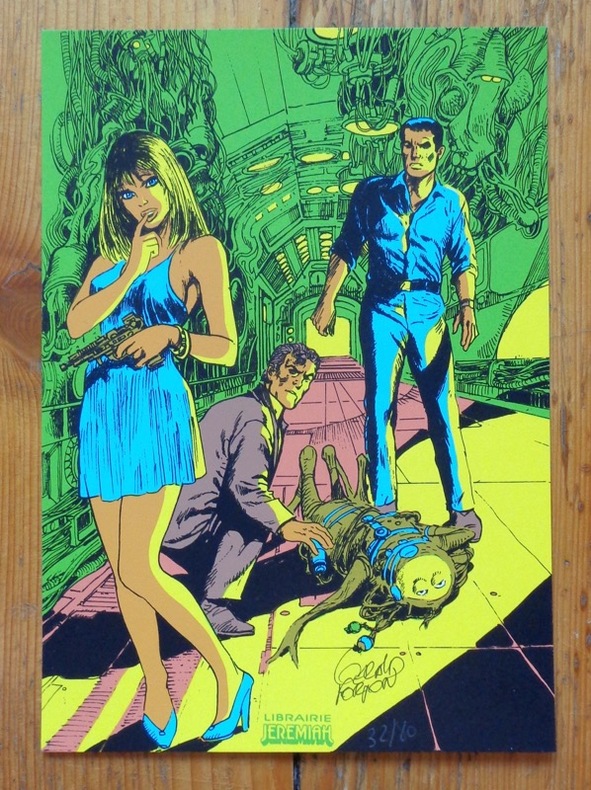
Forton Gérald:
Bob Morane 2.
Genève, Librairie Jérémiah. Petite sérigraphie au format 15 x 22 cm., à l'état de neuf.
Referenz des Buchhändlers : 5417
|
|
|
FORSTER J.R.
Histoire des Découvertes et des Voyages faits dans le Nord, mise en Français par M. Broussonet.
Paris, Cuchet, 1788. 2 volumes in-8 de xv, 399 pp. ; xii, 410, (2) pp. Cartonnage jaspé, p. de titre et de tom. (reliure de l'époque). Illustré de 3 grandes cartes dépliantes.
Referenz des Buchhändlers : PHO-753

|
|
|
FORISSIER (Béatrix).-
Les folles années du cinéma à travers la carte postale.
1981 Paris, Editions de l'Amateur, 1981, in 4°, cartonnage illustré de l'éditeur, 239 pages ; importatne iconographie.
Referenz des Buchhändlers : 79601
|
|
|
FORTIER-BEAULIEU (Paul)
Mariages et Noces Campagnardes dans les Pays ayant formé le Département de la Loire. Roannais - Forez - Partie du Beaujolais - Jarez. Avec 22 cartes Folkloriques, une carte Oro-hydrographique du département de la Loire et 27 planches hors-texte.
Librairie Orientale et Américaine Gustave-Paul / Maisonneuve, Collection "Les Littératures Populaires de toutes les nations", 1945 - Fort In-8 broché (25 x 17,2 cm) 367 pages. Avec 22 cartes folkloriques, une carte oro-hydrographique du département de la Loire et 27 planches hors-texte.- 810g.- Très frais, très bon état.
Referenz des Buchhändlers : 31062

|
|
|
FORTIFICATIONS. MANUSCRIT.
Plan d'un pentagone régulier suivant le second système de Mr le maréchal de Vauban.
[circa 1750]. 667 x 515 mm, sur beau papier de Hollande des papeteries C. & J. Honig.
Referenz des Buchhändlers : LBW-4163

|
|
|
FORTIS Alberto:
Travels into Dalmatia; containing general observations on the natural history of that country and the neighbouring islands; the natural productions, arts, manners and customs of the inhabitants: in a series of letters from Abbe Alberto Fortis, to the Earl of Bute, the Bishop of Londonderry, John Strange, Esq.... To which are added by the same author, observations on the island of Cherso and Osero. Translated from the Italian under the author's inspection. With an appendix and other considerable additions, never before printed. Illustrated with twenty copper plates.
London, printed for J. Robson, 1778. In-4 de [2]; X; 584 pages, plein veau brun, dos lisseorné de filets dorés, pièce de titre en maroquin rouge, supra-libros armorié en queue, filet doré encadrant les plats.
Referenz des Buchhändlers : 21875

|
|
|
Forbis, WIlliam H. [foreword, Mike Mansfield ; design, Sidney Feinberg ; endpaper maps, Jean Paul Tremblay ; jacket design, Paul
Japan Today : People Places Power ; The first complete "inside" book on Japan.
New York ; Evanston ; San Francisco ; London : Harper & Row Publishers 1975. 1975. Very Good. Blue cloth in gray red black and blue dustjacket ; ISBN: 0060113111 :; 9780060113117 LCCN: 75-6336 ; OCLC: 1500050 ; 1st edition 1st printing ; very slight foxing to textblock edges ; a few minor nicks to the top of dustjacket otherwise VG/VG New York ; Evanston ; San Francisco ; London : Harper & Row, Publishers, 1975. hardcover
Referenz des Buchhändlers : 2095

|
|
|
Forbis, William H. [foreword, Mike Mansfield ; design, Sidney Feinberg ; endpaper maps, Jean Paul Tremblay ; jacket design, Paul
Japan Today : People Places Power ; The first complete "inside" book on Japan.
New York ; Evanston ; San Francisco ; London : Harper & Row Publishers 1975. 1975. Good. blue cloth in gray red black and blue dustjacket ; ex-lib ; stamps ; pocket ; slight knock ; worn ; G New York ; Evanston ; San Francisco ; London : Harper & Row, Publishers, 1975. hardcover
Referenz des Buchhändlers : 1346

|
|
|
Foreign Economic Administration. Maps and Graphics Division, Enemy Branch
China Transportation Map
Washington D.C.: Maps and Graphic Division 1946. 1st. revision March 1946. Edges browned 4 inch and 2 inch tears on folds one with small loss at double fold small chip and stain to margins top and bottom some minor edge wear and marginal tears; a good copy. 1 pp. 110 x 90 cm. Color map of China's transportation routes during the war. Scale ca. 1:2750000; E 1000--E 1260/N 420--N 180. Map no. 1379 June 15 1945. OCLC shows only one copy at the LOC of this revised copy. Maps and Graphic Division unknown
Referenz des Buchhändlers : 33453
|
|
|
Foreign Economic Administration. Maps and Graphics Division Enemy Branch
China Transportation Map
Washington D.C.: Maps and Graphic Division 1946. 1st. revision March 1946. Edges browned 4 inch and 2 inch tears on folds one with small loss at double fold small chip and stain to margins top and bottom some minor edge wear and marginal tears; a good copy. 1 pp. 110 x 90 cm. Color map of China's transportation routes during the war. Scale ca. 1:2750000; E 1000--E 1260/N 420--N 180. Map no. 1379 June 15 1945. OCLC shows only one copy at the LOC of this revised copy. Maps and Graphic Division unknown books
Referenz des Buchhändlers : 33453
|
|
|
FOREST ROW
Forest Row and District. Road Map. Presented with the Compliments of Powell & Partner. NEAR FINE COPY
Folding uncoloured map on paper measuring 20.0 x 23.0 ins (approx. 51.0 x 58.4 cms) folding in 21 panels to 8.5 x 3.75 ins (approx. 21.5 x 9.5 cms), original photographic wrappers, yapped edges, a near fine copy. With numerous trade advertisements, a number illustrated.

|
|
|
FORESTER, C S & BRYANT, SAMUEL H (Maps & Drawings)
The Hornblower Companion
Chatham Publishing 2007. Imperial octavo softcover VG; all our specials have minimal description to keep listing them viable. They are at least reading copies complete and in reasonable condition but usually secondhand; frequently they are superior examples. Ordering more than one book may reduce your overall postage costs. Chatham Publishing 2007 paperback
Referenz des Buchhändlers : 353293
|
|
|
Forester, CS.; Bryant, Samuel [Illustrations and Maps] C. S.
The Hornblower Companion: An Atlas and Personal Commentary on the Writing of the Hornblower Saga with Illustrations and Maps
Little Brown and Company 1964. Hardcover. Good. Hardcover. First edition Little Brown and Company 1963. No jacket. Wine red boards bright gilt design of ship under sail. Dented tips. Scrape on front board. Dented tips and spine ends. Small creases on lower tips of some of the pages. Small foxing specks on leading edge of text block. 149 pps. Little, Brown and Company hardcover
Referenz des Buchhändlers : 250929003
|
|
|
FORISSIER, Beatrix.
Les Belles Années du Cinéma à travers la Carte Postale 1895-1935.
Hardcover in-4° 190 pp., abondamment illustre en noir, cartonnagee editeur illustre. Bel exemplaire. [PLC-12]
|
|
|
FOSSÉ DARCOSSE (Julie).
[FONTAINEBLEAU]Plan de la forêt de Fontainebleau.
1838. En 16 sections montées sur toile et repliées, formant un plan de 690 x 525 mm ; sous chemise et étui de l'époque en demi-maroquin à long grain bordeaux avec roulette d'encadrement, chiffre L. C. sur le premier plat de l'étui.
Referenz des Buchhändlers : LBW-8854

|
|
|
Foster, Leslie T.; Keller, C. Peter
The British Columbia Atlas of Wellness - Canadian Western Geographical Series Vol. 42
233 pages. References. Clean, bright and unmarked with negligible wear. Appears unread. An excellent copy. Book

|
|
|
FOURNIER (Louis).
(FRANCHE-COMTE). Nouvelle Carte des départements Doubs, du Jura et de la Haute-Saône formant avant 1790, l'ancienne province de Franche-Comté dressée d'après les cartes de l'Etat-Majour par Louis Fournier, employé des Ponts et Chaussées.
1873 73 x 118 cms, montée sur toile, départements coloriés Besançon Jules Roblot, Imprimeur-Libraire 1873, .
Referenz des Buchhändlers : 8093
|
|
|
FOURNIER
CARTE ROUTIERE ET ADMINISTRATIVE DU DEPARTEMENT DE LA SOMME
1861 reliure demi chagrin noir in-octavo à l'italienne, dos long décoré or, titre frappé or, titre or sur le premier plat, sans pagination, 1861 sans lieu,
Referenz des Buchhändlers : 7444
|
|
|
FOUCHE (M., agent voyer en chef).
Carte du canton d'Envermeu.
Paris, Régnier et Dourdet graveurs, 1870. Carte lithographiée in-plano de 100 x 72 cm, limites, routes et chemins en couleurs.
Referenz des Buchhändlers : 14518
|
|
|
FOUCHE (M., agent voyer en chef).
Carte du canton de Longueville.
Paris, Régnier et Dourdet graveurs, 1870. Carte lithographiée in-plano de 100 x 72 cm, limites, routes et chemins en couleurs.
Referenz des Buchhändlers : 14519
|
|
|
FOUCHE (M., agent oyer en chef).
Carte du canton de Tôtes.
Paris, Régnier et Dourdet graveurs, 1869. Carte lithographiée in-plano de 100 x 72 cm, limites, routes et chemins en couleurs.
Referenz des Buchhändlers : 14520
|
|
|
FOUCHE (M., agent Voyer en chef).
Carte du canton de Bolbec.
Paris, Régnier et Dourdet graveurs, 1865. Carte lithographiée in-plano de 100 x 72 cm, limites, routes et chemins en couleurs.
Referenz des Buchhändlers : 14522
|
|
|
FOUCHE (M., agent voyer en chef).
Carte du canton d'Eu.
Paris, Régnier et Dourdet graveurs, 1862. Carte lithographiée in-plano de 100 x 72 cm, limites, routes et chemins en couleurs.
Referenz des Buchhändlers : 14526

|
|
|
FOUCHE (M., agent Voyer en chef).
Carte du canton de Goderville.
Paris, Régnier et Dourdet graveurs, 1862. Carte lithographiée in-plano de 100 x 72 cm, limites, routes et chemins en couleurs.
Referenz des Buchhändlers : 14527
|
|
|
FOUCHE (M., agent Voyer en chef).
Carte du canton de Lillebonne.
Paris, Régnier et Dourdet graveurs, 1865. Carte lithographiée in-plano de 100 x 72 cm, limites, routes et chemins en couleurs.
Referenz des Buchhändlers : 14530
|
|
|
FOUCHE (M., agent Voyer en chef).
Carte du canton de Saint-Romain.
Paris, Régnier et Dourdet graveurs, 1864. Carte lithographiée in-plano de 100 x 72 cm, limites, routes et chemins en couleurs.
Referenz des Buchhändlers : 14531
|
|
|
FOUCHE (M., agent Voyer en chef).
Carte du canton de Blangy.
Paris, Régnier et Dourdet graveurs, 1870. Carte lithographiée in-plano de 100 x 72 cm, limites, routes et chemins en couleurs.
Referenz des Buchhändlers : 14535
|
|
|
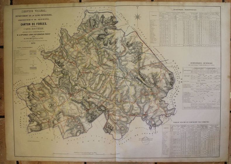
FOUCHE (M., agent Voyer en chef).
Carte du canton de Forges.
Paris, Régnier et Dourdet graveurs, 1870. Carte lithographiée in-plano de 100 x 72 cm, limites, routes et chemins en couleurs.
Referenz des Buchhändlers : 14536
|
|
|
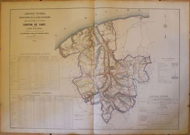
FOUCHE (M., agent Voyer en chef).
Carte du canton de Cany.
Paris, Régnier et Dourdet graveurs, 1864. Carte lithographiée in-plano de 100 x 72 cm, limites, routes et chemins en couleurs.
Referenz des Buchhändlers : 14552
|
|
|
FOUCHE (M., agent Voyer en chef).
Carte du canton de Doudeville.
Paris, Régnier et Dourdet graveurs, 1867. Carte lithographiée in-plano de 100 x 72 cm, limites, routes et chemins en couleurs.
Referenz des Buchhändlers : 14554
|
|
|
FOUCHE (M., agent Voyer en chef).
Carte du canton d'Ourville.
Paris, Régnier et Dourdet graveurs, 1867. Carte lithographiée in-plano de 100 x 72 cm, limites, routes et chemins en couleurs.
Referenz des Buchhändlers : 14557
|
|
|
FOUCHE (M., agent Voyer en chef).
Carte du canton d'Yerville.
Paris, Régnier et Dourdet graveurs, 1867. Carte lithographiée in-plano de 100 x 72 cm, limites, routes et chemins en couleurs.
Referenz des Buchhändlers : 14560
|
|
|
FOUCHE (M., agent Voyer en chef).
Carte du canton de Neufchatel.
Paris, Régnier et Dourdet graveurs, 1870. Carte lithographiée in-plano de 100 x 72 cm, limites, routes et chemins en couleurs.
Referenz des Buchhändlers : 14539
|
|
|
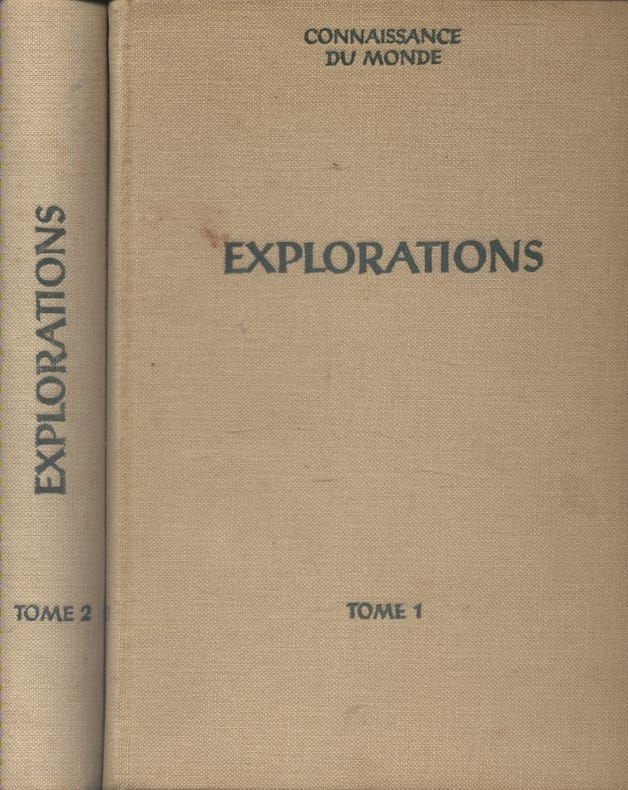
FOUQUET Gaétan - LEJARD André Nombreuses illustrations en noir et en couleurs. Cartes.
Explorations. Tomes I et II. Ouvrage conçu et réalisé sous la direction de Gaétan Fouquet et André Lejard avec le concours de Connaissance du Monde.
Couverture rigide. Reliures toile. 2 volumes 19 x 27 cm. Rousseurs.
Referenz des Buchhändlers : 133807
|
|
|
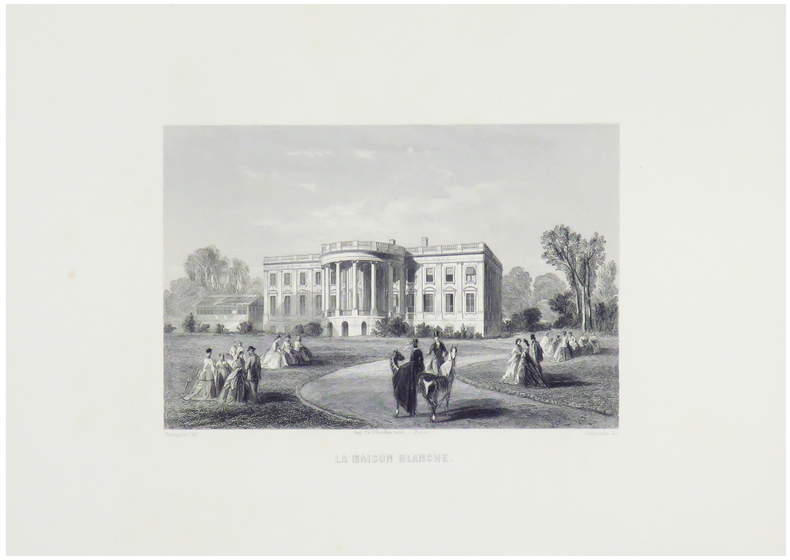
FOULQUIER.
La Maison Blanche.
Paris, [circa 1860]. 124 x 167 mm.
Referenz des Buchhändlers : LBW-1255
|
|
|
FOUREAU Fernand:
Mission chez les Touareg. Mes deux intinéraires sahariens d'octobre 1894 à mai 1895. Rapport adressé à Monsieur le Ministre de l'instruction publique, à Monsieur le Gouverneur de l'Algérie, à l'Académie des inscriptions et belles-lettres.
Paris, Augustin Challamel, librairie maritime et coloniale, novembre 1895. Grand in-8 broché de [6]-197-[3] pages, couverture sable imprimée en noir. Dos plié (avec pour effet quelques cahiers un peu déboîtés), auréoles en bord inférieur de la couverture, coin de la première garde coupé.
Referenz des Buchhändlers : 10487

|
|
|
FOUQUERAY (Charles) & DEMOULIN (J.).
Office Colonial Scolaire. Et.ts français dans l'Inde. Kerguelen, S.t Paul, N.lle Amsterdam. N°6.
Paris, Librairie Ch. Delagrave, [1902]. 1 x 1,25 m, marges comprises.
Referenz des Buchhändlers : LBW-8845

|
|
|
FOUREAU FERNAND
RAPPORT DE MA MISSION AU SAHARA et CHEZ LES TOUAREG AZDJER OCTOBRE 1893-MARS 1894
édité par Augustin Challamel librairie coloniale en 1894 un volume de texte et une pochette renfermant 4 grandes cartes dépliantes format : 16,5 x 25 cm, 280 pages, broché. état : petits manques en tête et en queue du dos du volume de texte, couverture salie, marques de plis et petites déchirures sur les bords, brochage un peu lâche (voir photos); pochette des cartes : pochette séparée en deux, couverture salie, déchirures à certains plis des cartes sans manque (photos supplémentaires sur demande) Fernand FOUREAU, né en 1850 à Saint-Barbant en Haute-Vienne, mort en 1914 à Paris. Explorateur français du Sahara et gouverneur de la Martinique de 1908 à 1913.
Referenz des Buchhändlers : 70

|
|
 Per e-mail erhalten
 Als pdf-Dokument herunterladen
 RSS feed


