|
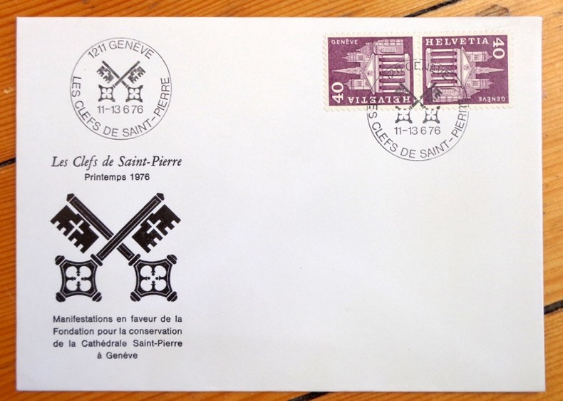
Genève:
Les Clefs de Saint-Pierre - Printemps 1976.
Les Clefs de Saint-Pierre, 1976. Enveloppe au format 16 x 11 cm., ornée d'une vignette et de 2 timbres. Affranchissement philatélique, à l'état de neuf.
Referenz des Buchhändlers : 4269
|
|
|
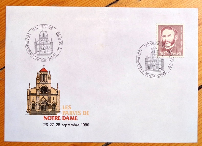
Genève:
Les parvis de Notre Dame / Henri Dunant, Genève.
1976. Enveloppe au format 16 x 11.5 cm, parue à l'occasion de la grande manifestation en faveur de la restauration de la basilique Notre Dame : Les Parvis de Notre-Dame . Timbre au portrait de Henri Dunant, vignette en coin inférieur, affranchissement philatélique de septembre 1980.
Referenz des Buchhändlers : 4286
|
|
|
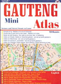
GEO MAPS
GAUTENG Mini Atlas
<p>Unmarked. Of a size to fit a cubby hole or backpack. Unread. Includes all southern Gauteng; including Pretoria and its Satellite towns. Very detailed coloured maps. Better than Google in many ways. Scarce . Plus FREE Southern Africa Road folding Map. FREE</p> paperback
Referenz des Buchhändlers : 16819
|
|
|
Geo. Wilkins Kendall [illus, maps]
Narrative of the Texan Santa Fe Expedition Comprising a Description of a Tour Through Texas and.etc 2 Volume Set
The Steck Company 1935. Hardcover. Very Good. . 2 vols. A very nice set near fine. Green cloth boards with gilt lettering. Pages/boards clean and vibrant binding tight. Protected in removable archival plastic sleeve. The Steck Company hardcover
Referenz des Buchhändlers : mon0002574435
|
|
|
Geoffrey Palmer; Noel Lloyd
The Observer's Book of London
No marks or inscriptions. No creasing to covers or to spine. A very clean very tight copy with bright unmarked boards and very tiny bump to upper rear corner. 192pp. Revised edition of the standard Observer book on London.

|
|
|
Geographers, Institute Of British Philip's Maps
Philip's Rgs Atlas Of The World: 2026 Edition
Octopus Publishing Group 2025. Hardcover. New. 448 pages. 11.34x1.57x14.57 inches. Octopus Publishing Group hardcover
Referenz des Buchhändlers : __1849077363 ISBN : 1849077363 9781849077361

|
|
|
Geographers' A-Z Map Company Staff
A-Z Leicester Street Atlas
96 pages, maps, index. eng
|
|
|
Geographia
Geographia Linen Backed Large Scale Plan of Nottingham
Linen backed folded Plan of Nottingham in excellent condition - not torn or marked or creased. Opens up to 29 x 39 inches. Covers slightly dusty/rubbed with creasing to oversized edges. 1pp. Coloured linen-backed plan of City of Nottingham and immediate surrounds. Undated ca 1930s.
|
|
|
Geographia
Vintage Denmark Map 1970
No marks or inscriptions to map or covers. Very minor creasing to covers. A very clean not torn map with bright unmarked boards. 1pp. Opens up to 23 x 30 inch vintage Geographia map of Denmark in 1970.
|
|
|
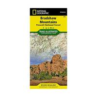
Geographic Maps National
National Geographic Trails Illustrated Map Bradshaw Mountains Prescott National Forest: Arizona
National Geographic Maps 2010. Paperback. New. map edition. 2 pages. 0.25x9.25x4.25 inches. National Geographic Maps paperback
Referenz des Buchhändlers : 1-1566955173 ISBN : 1566955173 9781566955171
|
|
|
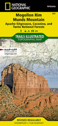
Geographic Maps National
National Geographic Trails Illustrated Map Mogollon Rim & Munds Mountain Wilderness Areas Apache-sitgreaves Coconino & Tonto National Forests: Arizona
National Geographic Maps 2010. Map. New. map edition. 2 pages. 0.25x9.25x4.25 inches. National Geographic Maps unknown
Referenz des Buchhändlers : 1-1566955149 ISBN : 1566955149 9781566955140
|
|
|
Geographic Maps National
National Geographic Trails Illustrated Map Bradshaw Mountains Prescott National Forest: Arizona
National Geographic Maps 2010. Paperback. New. map edition. 2 pages. 0.25x9.25x4.25 inches. National Geographic Maps paperback
Referenz des Buchhändlers : __1566955173 ISBN : 1566955173 9781566955171

|
|
|
Geographical Section, General Staff No. 4042
British World War II Map of Walcheren-Amsterdam
38" wide by 25.5" high. Dated June, 1944. Moderate wear. Nice copy. Map

|
|
|
Geological Maps of the Oil and Gas fIelds of Japan No. 1
Geological map Aoyamaoku.
1961. Geol. Surv. Japan. 1 fold. & col. geol. map 1:50000 legend in Japanese and English very good. unknown
Referenz des Buchhändlers : 104501
|
|
|
George BUDAY.
The History of the Christmas Card.
London, Spring Books, 1954. In 8°, reliure de l’éditeur, jaquette illustrée (déchirures sans manque). xxiii, 304 pp., illustrations in et hors texte.
Referenz des Buchhändlers : AMA-1104
|
|
|
George E. McAvoy . Illustrated by Maps & Photos
And Then There Was One - Signed & Dated by the Author First Edition. 1988
Littleton NH: Littleton the Crawford Press 1988 1988. 1st Edition 1st Printing. Soft cover. Near Fine. Illustrated. About Fine/AF. First. 8vo - over 7" - 9" tall. As New HC/DJ. First. Signed by Author. Flat signed on the Title page. 336 pages. NOTE: Prior owner/dealer wrote a price and number on the front-1/2 title page in ink no less sorry! <br/> <br/> Littleton, NH: Littleton, the Crawford Press, 1988 paperback
Referenz des Buchhändlers : 026072
|
|
|
George E. McAvoy . Illustrated by Maps & Photos
And Then There Was One - First Edition. 1988
Littleton NH: Littleton the Crawford Press 1988 1988. 1st Edition 1st Printing. Hardcover. About Fine/Near Fine. Hard Cover. Illustrated. AF/NF. First. 8vo - over 7" - 9" tall. As New HC/DJ. First. 336 pages nicely illustrated with many B&W color photos illustrations maps drawings etc. map eps from Leavitt's Map 1878. <br/> <br/> Littleton, NH: Littleton, the Crawford Press, 1988 hardcover
Referenz des Buchhändlers : 025645
|
|
|
George E. McAvoy, Illustrated by Maps & Photos
And Then There Was One - First Edition History of the Hotels of the Summit and the West Side of Mt. Washington.
Littleton NH: the Crawford Press 1988 1988. No Binding. Near Fine. 4to - over 9¾" - 12" tall. SCARCE: Large Trade Wraps. Illustrated. First Edition. 336 pages. <br/> <br/> Littleton, NH: the Crawford Press, 1988 unknown
Referenz des Buchhändlers : 025043
|
|
|
George E. McAvoy, Illustrated by Maps & Photos
And Then There Was One - First Edition History of the Hotels of the Summit and the West Side of Mt. Washington.
Littleton NH: the Crawford Press 1988 1988. Soft cover. Near Fine. 4to - over 9¾" - 12" tall. SCARCE: Large Trade Wraps. Illustrated. Near Fine/NA. First Edition. 336 pages <br/> <br/> Littleton, NH: the Crawford Press, 1988 paperback
Referenz des Buchhändlers : 018263
|
|
|
George E. McAvoy, Illustrated by Maps & Photos
And Then There Was One - First Edition History of the Hotels of the Summit and the West Side of Mt. Washington.
Littleton NH: the Crawford Press 1988 1988. Soft cover. Near Fine. 4to - over 9¾" - 12" tall. SCARCE: Large Trade Wraps. Illustrated. Near Fine/NA. First Edition. 336 pages. Gift inscription on front page. <br/> <br/> Littleton, NH: the Crawford Press, 1988 paperback
Referenz des Buchhändlers : 016515
|
|
|
George III British Library - Barnard, Sir Frederic Augusta
Bibliothecae Regiae Catalogus. (5 Bände). + Catalogue of Maps, Prints, Drawings, etc. forming the Geographica and Topographical Collection attached to the Library of his late Majesty King George the Third. (1 Band). Zusammen 6 Bände (= vollständig).. 5 Bände + 1 Band = 6 Bände (komplett). Erste und einzige Ausgabe.
London, The Trustees of the British Museum 1820-1829. Mit 2 Schabkunst-Porträts und 2 Holzschnitt-Vignetten. Gr.-2° (46 x 33,5 cm). Professionell restaurierte Pappbände der Zeit mit gedruckten Orig.-Papierrückenschildern.
Referenz des Buchhändlers : 5146264

|
|
|
GEORGE PHILIP & SON LTD. (ENGRAVERS)
Map of the East Indian Railway showing stations and mileage by Shortest route.
Calcutta.: E. I. R. Press. circa1910. Folding engraved map 33.5 x 73.5 cm river systems in blue attractively bursting the borders of the map inset map of the network into Calcutta legend noting stations lines under construction and foreign railways; original folds two small fold splits with no loss slight overall toning more noticeable at the folds in very good condition. Attractive map capturing one of the busiest areas of a staggeringly vast railway network. The Barharwa-Azimganj-Katwa loop is marked under construction. Scarce. . E. I. R. Press unknown
Referenz des Buchhändlers : 175858
|
|
|
George S. May. Maps by Victor H. Hogg.
War 1812.
Mackinac Island State Park Commission. Very Good. Soft cover. 1st Edition. 1962. Mackinac Island State Park Commission paperback
Referenz des Buchhändlers : 101770
|
|
|
Georges Brun
Promenades vauclusiennes (15 circuits touristiques)
Le Nombre d'Or 1973 310 pages in8. 1973. broché. 310 pages. Guide touristique proposant 15 circuits en voiture dans le Vaucluse couvrant 1115 km et 73 communes autour de Carpentras. Il inclut des descriptions de monuments des notices biographiques des cartes et des photographies
Referenz des Buchhändlers : 13099

|
|
|
GEORGES COLLEUIL
TAROT L'ENCHANTEUR Une nouvelle vision du tarot de Marseille suivi d'une méthode d'analyse de créativité et de connaissance de soi par le référentiel de Naissance
Broché - 14 x 22 - année 1999 - 219 pp - Editions Arkhana vox - illustrations
Referenz des Buchhändlers : 16519
|
|
|
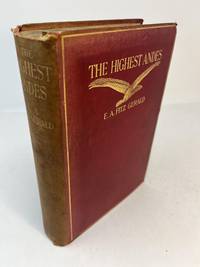
Gerald, E. A. Fitz. With chapters by Stuart Vines. Maps by A. E. Lightbody
THE HIGHEST ANDES. A Record of the First Ascent of Aconcagua and Tupungato in Argentina and the Exploration of the Surrounding Valleys
London: Methuen & Co 1899. 1st edition. Hardcover. Good. A. E. Lightbody. 1st edition thus 1899. A Good copy. 4to. 390 pp. with two maps at rear. Bound in red cloth with titles in gilt on front cover and spine. Spine is faded; tips edges and spine; frontis page partially detached; scattered foxing throughout. Methuen & Co hardcover
Referenz des Buchhändlers : 31462
|
|
|
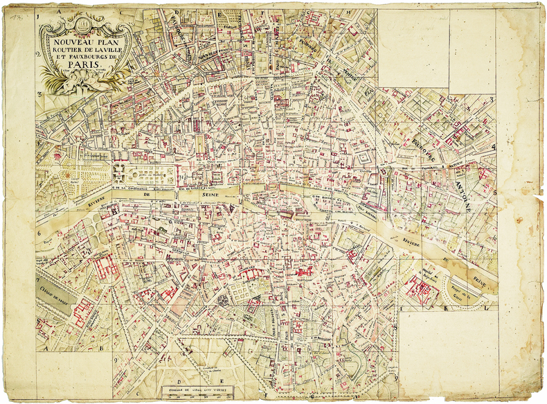
GERARDI. Plan manuscrit de Paris.
Nouveau plan routier de la ville et fauxbourgs de Paris. 1795 Gerardi fecit.
1795. En deux feuilles jointes de 545 x 646 mm.
Referenz des Buchhändlers : LBW-3817
|
|
|
GERARDMER
Carte couleurs au 1/100 000?. Sans date.
Une feuille 31x51 cm sous couverture toil?e. Marges d?coup?es.
|
|
|
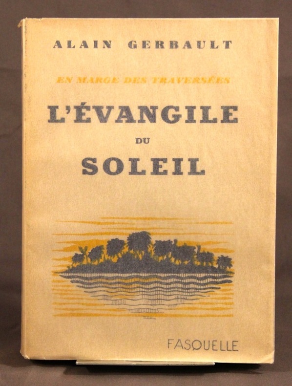
GERBAULT Alain:
L’Evangile du soleil. En marge des traversées.
Paris, Fasquelle, 1932. In-8 broché de 218-[4] pages. Bel état.
Referenz des Buchhändlers : 2136
|
|
|
Gerber, Peter R.; Bruggmann, Maximilien
Indians of the Northwest Coast
Book is in excellent condition, with a little sunning to the lower edge of front cover as the only flaw. Binding is solid and square, covers have sharp corners, exterior shows no other blemishes, text/interior is clean and free of marking of any kind. Dust jacket shows some shelf wear, edge wear, one 1" tear at lower front. 232 pages with large color photos throughout, some b&w, maps, drawings. Contents include: Salmon and cedar, Tlingit, Tsimshian, Rulers and subjects, Haida, Kwakiutl, raven and shamans, Nootka, Coast Salish, First nations, Visible heritage, Contemporary art, Portraits of the artists, etc.

|
|
|
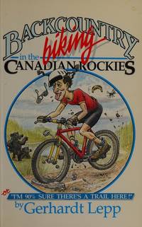
Gerhardt Lepp; Jo Ann Draper maps; Colynn Kerr drawings
Backcountry Biking in the Canadian Rockies
Calgary: Rocky Mountain Books 1988. Paper bound second printing illustrated with over 40 maps Pp188. Includes index. As new. 275 grams. All books in stock and available for immediate shipment from Winnipeg Manitoba. Calgary: Rocky Mountain Books, 1988 unknown
Referenz des Buchhändlers : 21973 ISBN : 0969003889 9780969003885
|
|
|
GERIN, DALMONT, SMITH et FONTAINE (Carte gravée par)
Algérie d'après les cartes de l'état-major et les documents du Ministère de la guerre.
Paris, Landriveau-Goujon, 1882. Carte en couleurs in-plano repliée, support toilé dans couverture cartonnée au lettrage doré. Echelle 1/11000000e. Carte No 21 - (Atlas usuel No 28 - Atlas universel No 41). Parfait état.Carte d'ensemble des rapports entre la France, l'Algérie, la Sénégambie et le Nord de l'Afrique.
Referenz des Buchhändlers : 15175
|
|
|
GERMAIN, A.:
Notions d'hydrographie expeditive à l'usage des officiers de Marine,2e edition revue par M.F.Hanusse,
Paris, Imprimerie nationale, 1904, in-4,cartonné, 119p., avec des schémas,et planches depliantes,bon etat
Referenz des Buchhändlers : 10331b
|
|
|
Gerrard, David (editor)
The Hidden Places of Cheshire : Including the Wirral
Book in mint unread condition. 198pp.

|
|
|
GERSON (Roger).
[LUXEMBOURG] Diekirch, Grand-Duché de Luxembourg. Berceau et centre du tourisme luxembourgeois. Société Nationale des Chemins de Fer Luxembourgeois.
Diekirch, Syndicat d'Initiative, [vers 1950]. 985 x 600 mm.
Referenz des Buchhändlers : LBW-8666

|
|
|
Gertslacher , Anne et al.
China for Women : Travel and Culture
No inscriptions or marks. No creasing to covers or to spine. A lovely clean very tight copy with bright unmarked boards and no bumping to corners. 357pp. For the tourist or the armchair traveller, this book brings to life the complex culture and history of the world's most populous nation. Over a dozen women of various backgrounds including world-famous authors Ding Ling and Agnes Smedley describe what it is like to live in China.

|
|
|
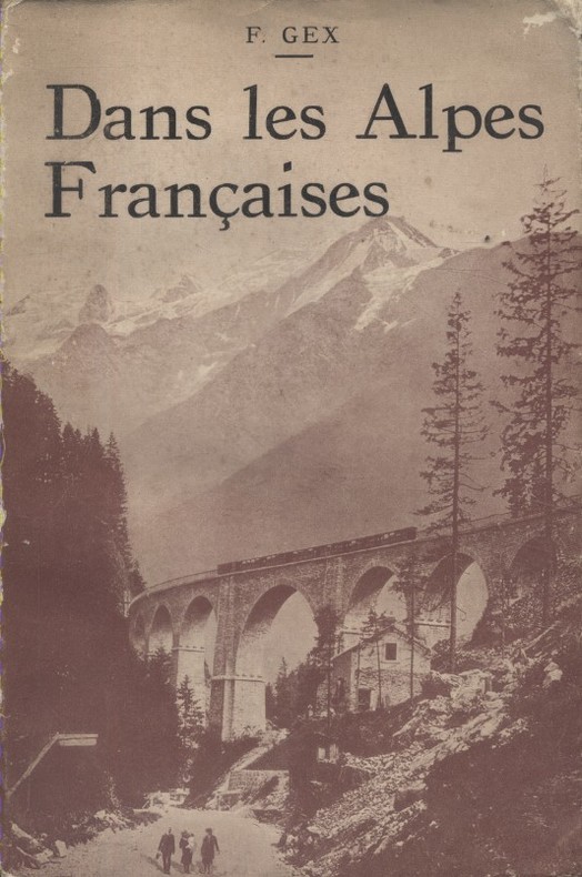
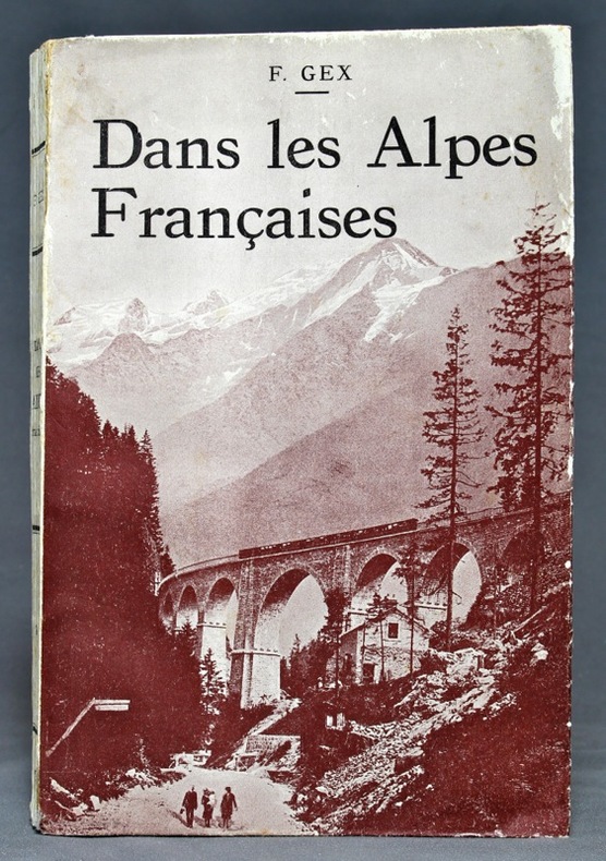
GEX F. Nombreuses photos et cartes hors-texte.
Dans les Alpes françaises. Du Mont Cenis au Léman. Le Mont Blanc géant des Alpes.
Couverture souple. Broché. 305 pages.
Referenz des Buchhändlers : 129435
|
|
|
GEX F.:
Dans les Alpes françaises. Une vue d'ensemble - Une excursion - Un massif: Alpes du Nord et Alpes du Sud, du Mont Cenis au Léman, Le Mont Blanc, géant des Alpes.
Paris, J. de Gigord, 1929. In-8 broché de [4]-305 pages, couverture photographique rempliée.
Referenz des Buchhändlers : 13648
|
|
|
GIART Jean:
Océanie.
Paris, Gallimard, coll. L'univers des formes, 1963. In-4 de [12]-447-[10] pages, pleine toile rouge avec titre doré au dos et au premier plat, jaquette photographique couleurs. Minimes accrocs en tête de jaquette, pour le reste en parfaite condition.
Referenz des Buchhändlers : 9731

|
|
|
Gibbon, David (designed by)
New England : A Picture Book to Remember Her By
No marks or inscriptions. A very clean very tight copy with bright unmarked boards and no bumping to corners. Dust jacket not price clipped or marked or torn with minor creasing to upper rear edge and traces of storage. Unpaginated. A picture book with captions showing the attractive scenery of the six states of America's New England.

|
|
|
Gibbons Herbert Adams
Venizelos
New York: Houghton Mifflin. 1920 Book. Very Good . Cloth. 1st US Edition. Greek and Balkan politicsWorld War I and the various contributions of Eleftherios Venizelos up to the Peace Conference at Versailles and the Greek claims in Asia Minor.Foldout coloured ethnographical map of "Turkey in-Europe" 384p. illus platesmaps index. Crispclean tight text.Spine a little faded and scuffed else fine. Only later copies of this US edition found in in WorldCat . Houghton Mifflin. hardcover
Referenz des Buchhändlers : 040036
|
|
|
Gibbons, Garry
Historic Places of Britain
Inscription to front end paper. No other marks or inscriptions. A lovely clean very tight copy with bright unmarked boards and no bumping to corners. Dust jacket price clipped but not marked or torn or creased. 96pp. Beautiful capioned photographs from around Britain.

|
|
|
Gibbons, Herbert Adams
Venizelos
Greek and Balkan politics,World War I and the various contributions of Eleftherios Venizelos, up to the Peace Conference at Versailles and the Greek claims in Asia Minor.Foldout coloured ethnographical map of "Turkey in-Europe") 384p., illus plates,maps index. Crisp,clean tight text.Spine a little faded and scuffed, else fine. [Only later copies of this US edition found in in WorldCat ] Book
|
|
|
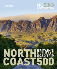
Gibbs, Emma/ Collins Maps
North Coast 500: Britain’s ultimate road trip
Collins 2022. Hardcover. New. new edition edition. 232 pages. 9.25x7.76x0.75 inches. Collins hardcover
Referenz des Buchhändlers : __000854705X ISBN : 000854705X 9780008547059
|
|
|
Gibelin Marius
METIERS ET SAVOIR FAIRE DE TOUJOURS
DE BOREE 2015 309 pages 24 2x2 8x29 4cm. 2015. Broché. 309 pages. Cet ouvrage de Marius Gibelin présente plus de cent métiers pratiqués par nos aïeux entre 1850 et 1920 principalement en France rurale. À travers de nombreuses illustrations (cartes postales photographies anciennes) et anecdotes l'auteur décrit les techniques outils et gestes des artisans du bois de la pierre de la terre du textile des métaux etc. Il rend hommage à ces savoir-faire qui ont façonné notre culture et nos sociétés
Referenz des Buchhändlers : 13895

|
|
|
GIDE André
Le Retour du Tchad Suite du Voyage au Congo. Carnet de route
Paris Gallimard NRF 1928 In-12 Demi-reliure à coins
Referenz des Buchhändlers : 010179
|
|
|
GIDE André:
Voyage au Congo. Carnets de route. [avec] Le retour au Tchad. Suite du Voyage au Congo. Carnets de route.
Paris, Gallimard, 1927-1928. 2 volumes brochés in-12 de 249-[7] et 252-[4]pages.
Referenz des Buchhändlers : 20524

|
|
|
Gigas, Johannes
Episcopatus Hildesiensis Descriptio Novissima Authore Ioanne Gigante D. Med. et Math. [Altkolorierter Original-Kupferstich / original colored copper engraving].
o.J. Johannes Michael Gigas (gräzisiert, eigentlich Riese), geboren 1582 in Lügde, Fürstbistum Paderborn, gestorben 1637 in Münster. Deutscher Kartograf, Mediziner (Leibarzt des Kurfürsten Ferdinand I. von Bayern), Mathematiker und Physiker. [2 Warenabbildungen]
Referenz des Buchhändlers : 12066DB

|
|
|
Gil Baer Marie-Thérèse
Faites des patiences : 50 patiences bien expliquées
Librairie Stock Broché In-12 (11,8 x 17,5 cm), broché, 232 pages ; dos fendu, manque au dos en queue, mors frottés, rousseurs et traces sur les plats et tranches, note manuscrite en première garde, par ailleurs intérieur bien conservé, état moyen. Livraison a domicile (La Poste) ou en Mondial Relay sur simple demande.
Referenz des Buchhändlers : pl2360
|
|
|
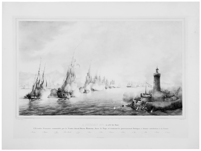
GILBERT (Pierre-Julien).
[COMBAT du TAGE] 11 juillet 1831 (à 2 hes du soir). L'Escadre française commandée par le contre-amiral baron Roussin, force le Tage et contraint le gouvernement portugais à donner satisfaction à la France.
1837. 509 x 752 mm, sur Chine monté.
Referenz des Buchhändlers : LBW-5168
|
|
 Per e-mail erhalten
 Als pdf-Dokument herunterladen
 RSS feed


