|
Hema Maps (Firm)
New Zealand road atlas
paperback. Good. Access codes and supplements are not guaranteed with used items. May be an ex-library book. paperback
Referentie van de boekhandelaar : 1875992154.G ISBN : 1875992154 9781875992157
|
|
|
Hema Maps PtyLtd y. Lt
New Zealand Touring Atlas 1:305K A5 Size 145Pages
Hema Maps New Zealand Ltd 2014. Paperback. Very Good. May have limited writing in cover pages. Pages are unmarked. ~ ThriftBooks: Read More Spend Less.Dust jacket quality is not guaranteed. Hema Maps New Zealand Ltd paperback
Referentie van de boekhandelaar : G1877302929I4N00 ISBN : 1877302929 9781877302923
|
|
|
Hema Maps PtyLtd y. Lt
New Zealand Touring Atlas 1:305K A5 Size 145Pages
Hema Maps New Zealand Ltd 2014-10-20. Paperback. New. Spiral-bound.New Inside and Outside. Clean and crisp pages w/no markings! You will be pleased. Excellent book! z1s170B Some minor shelf wear on cover. Fast Shipping Hema Maps New Zealand Ltd paperback
Referentie van de boekhandelaar : SKU1022886 ISBN : 1877302929 9781877302923
|
|
|
Hema Maps Pty LTD
New Zealand touring atlas NP
Paperback. Very Good. paperback
Referentie van de boekhandelaar : GOR008794492 ISBN : 1877302929 9781877302923

|
|
|
Hema Maps Pty LTD
New Zealand touring atlas NP
Paperback. Good. paperback
Referentie van de boekhandelaar : GOR008607824 ISBN : 1877302929 9781877302923
|
|
|
Hema Maps Pty LTD
New Zealand touring atlas spir. NP hema
Hema Maps Pty LTD 10/20/2014. 5th Revised edition. Paperback. Used; Good. WE SHIP WITHIN 24 HRS FROM LONDON UK 98% OF OUR ORDERS ARE RECEIVED WITHIN 7-10 DAYS. We believe you will be completely satisfied with our quick and reliable service. All orders are dispatched as swiftly as possible! Buy with confidence! Greener Books. Hema Maps Pty LTD paperback
Referentie van de boekhandelaar : 2324494 ISBN : 1877302929 9781877302923
|
|
|
Hema Maps Pty LTD
New Zealand handy atlas NP
Paperback. Very Good. paperback
Referentie van de boekhandelaar : GOR006844856 ISBN : 1877302937 9781877302930
|
|
|
Hema Maps Staff
OECD Economic Surveys : New Zealand 1991
Dorling Kindersley. Used - Very Good. Used book that is in excellent condition. May show signs of wear or have minor defects. Dorling Kindersley unknown
Referentie van de boekhandelaar : 52293110-6 ISBN : 0751348368 9780751348361
|
|
|
Hema Maps Staff
OECD Economic Surveys : New Zealand 1991
Dorling Kindersley. Used - Good. Used book that is in clean average condition without any missing pages. Dorling Kindersley unknown
Referentie van de boekhandelaar : 51307599-75 ISBN : 0751348368 9780751348361
|
|
|
Hema Maps Staff
OECD Economic Surveys : New Zealand 1991
Houghton Mifflin Harcourt Publishing Company. Used - Very Good. Used book that is in excellent condition. May show signs of wear or have minor defects. Houghton Mifflin Harcourt Publishing Company unknown
Referentie van de boekhandelaar : 50867560-6 ISBN : 0395710766 9780395710760
|
|
|
Hema Maps Staff
OECD Economic Surveys : New Zealand 1991
Dorling Kindersley. Used - Very Good. Ships from the UK. Former library book; may include library markings. Used book that is in excellent condition. May show signs of wear or have minor defects. Dorling Kindersley unknown
Referentie van de boekhandelaar : 42268773-75 ISBN : 0751348368 9780751348361
|
|
|
Hema Maps Staff
OECD Economic Surveys : New Zealand 1991
Berlitz Publishing. Used - Good. Ships from the UK. Used book that is in clean average condition without any missing pages. Berlitz Publishing unknown
Referentie van de boekhandelaar : 6535886-20 ISBN : 9812462082 9789812462084
|
|
|
Hema Maps Staff
OECD Economic Surveys : New Zealand 1991
Houghton Mifflin Harcourt Publishing Company. Used - Good. Ships from the UK. Former library book; may include library markings. Used book that is in clean average condition without any missing pages. Houghton Mifflin Harcourt Publishing Company unknown
Referentie van de boekhandelaar : 16786645-20 ISBN : 0395710766 9780395710760
|
|
|
Hema Maps PtyLtd y. Lt
Perth Greater 1:80K Hema Map
map. Good. Access codes and supplements are not guaranteed with used items. May be an ex-library book. unknown
Referentie van de boekhandelaar : 1865001368.G ISBN : 1865001368 9781865001364
|
|
|
Hema Maps Pty LTD
Queensland state NP handy r/v r hema: State Handy Map / camping/Rest areas / National parks / Fully indexed
Paperback. Very Good. paperback
Referentie van de boekhandelaar : GOR007642131 ISBN : 1865007145 9781865007144
|
|
|
Hema Maps PtyLtd y. Lt
Sydney & Region Handy Map 1:100K- 2014: HEMA
Hema Maps Pty.Ltd 2015. Very Good. Ammareal gives back up to 15% of this item's net price to charity organizations. Hema Maps Pty.Ltd unknown
Referentie van de boekhandelaar : G-535-134 ISBN : 1865007218 9781865007212
|
|
|
Hema Maps (Firm)
Sydney Handy Map
map. Good. Access codes and supplements are not guaranteed with used items. May be an ex-library book. unknown
Referentie van de boekhandelaar : 1875992413.G ISBN : 1875992413 9781875992416
|
|
|
Hema Maps Staff
The Pocket Guide to the Red Centre
Eight Mile Plains QLD Australia: Hema Maps Pty Limited 2003 158 pages. Books listed here are not stored at the shop. Please contact us if you want to pick up a book from Newtown. Paperback. Very Good. Size B: 5"-6" Tall 125-151mm. Hema Maps Pty, Limited paperback
Referentie van de boekhandelaar : 47847 ISBN : 1865001406 9781865001401
|
|
|
Hema Maps Staff
Western Australia
Nucolorvue Productions 1986. Paperback. Like New. Pages are clean and are not marred by notes or folds of any kind. ~ ThriftBooks: Read More Spend Less.Dust jacket quality is not guaranteed. Nucolorvue Productions paperback
Referentie van de boekhandelaar : G0858580942I2N00 ISBN : 0858580942 9780858580947
|
|
|
HENNEQUIN (Colonel)
Etude historique sur l'exécution de la carte de Ferraris et l'évolution de la cartographie topographique en Belgique, depuis la publication de la grande carte de Flande de Mercator (1540) juque dans ces derniers temps.
Bruxelles, Typographie Ve Ch. Vanderauwera, 1891. "15 x 23, 131 pp., 4 cartes dépliantes, 1 liste alphabétique dépliante, reliure dos toilé, couverture remontée, état moyen, (couverture défraîchie; peu de rousseurs)."
Referentie van de boekhandelaar : 43690
|
|
|
HENNEQUIN Docteur
Histoire de Void
(Noniantus ou Noviantus)dans le pays des Leuquois depuis l’an 50 avant Jésus Christ jusqu’à nos jours.In 8 broché,faux titre,titre,76 pages en partie non coupé. Une lithographie hors-texte,figures dans le texte, cartes dans le texte et pleine page.3 cartes et un plan dépliants (jardins de la Louvière)Imprimerie E.Réau 1876.Edition originale Rousseurs éparse plus ou moins fortes.Rare
Referentie van de boekhandelaar : 3675

|
|
|
Henri Brives . François Perroy . Préf Guy Penaud
Moi, noë chabot , curé-bistrot
Périgueux , Copédit 1986
Referentie van de boekhandelaar : 1083
|
|
|
Henri Vernes / Bob Morane - William Vance - Pierre Joubert - Lucien Logé - Frank Leclercq - René Follet - Collectif.
Bob Morane : Série complète des 9 cartes postales reprenant différentes couvertures d'éditions originales d'Henri Vernes illustrées par William Vance, Pierre Joubert, Lucien Logé + 6 marque-pages édités par l'Âge d'Or + une carte de voeux perpétuelle illustrée par René Follet.
Editions Calliope 2001 / L'Âge d'Or. Magnifique lot des 9 cartes postales composant la série complète consacrée à Henri Vernes et à Bob Morane. Format 10 x 15 cm. Contient les reproductions des livres suivants : La Porte Ouverte ( C.H.Dewisme ) - La Véritable Histoire de Will Williamson ( Cal.W.Bogar ) - La Belle Nuit pour un Homme Mort ( C.H.Dewisme ) - Brandy Street ( Gaston Bogart ) - A la recherche du Monde Perdu ( Ray Stevens ) - Les Zombis ou le Secret des Morts-Vivants ( C.H.Dewisme ) - 3 Aventures de Bob Morane ( Henri Vernes ) - La Main Noire ( Henri Vernes ) - Bob Morane et Bill Ballantine ( William Vance ). Neuf. On joint 6 marque-pages édités par l'Âge d'Or, illustrés par Frank Leclercq et une carte de de voeux perpétuelle des Editions L'Âge d'Or, illustrée par René Follet au format 16,5 x 10,5 cm. Tous les objets sont en état superbe.
Referentie van de boekhandelaar : 20167

|
|
|
HENRIOT, J.N.
Plan de Paris en 1861 divisé en 20 arrondissements
1 carte dépliante en couleurs, format 62 x 89 cm, Chez A. Bes et F. Dubreuil, Paris, 1861 Charmante carte lithographiée en couleurs de Paris au temps du baron Haussmann. Bon état (minimes usures et fentes en plis, cachet de colportage au verso). Français

|
|
|
HENRIOT, J.N.
Plan de Paris en 1861 divisé en 20 arrondissements
1 carte dépliante en couleurs, format 62 x 89 cm, Chez A. Bes et F. Dubreuil, Paris, 1861
Referentie van de boekhandelaar : 47981

|
|
|
HENRY (Maurice).
Maurice Henry Dessins.
Paris Galerie des 2 îles 1946 1 vol. Broché plaquette in-8 agrafée, 4 ff. Invitation à une exposition de dessins de Maurice Henry du 22 décembre 1946 au 12 janvier 1947, avec un poème de 4 pages de Jacques Prévert intitulé "Un beau jour..." Rare.
Referentie van de boekhandelaar : 120521
|
|
|
Henry Bidou
La Conquête des Pôles- huit reproductions et six cartes
Gallimard 1940 347 pages in8. 1940. broché. 347 pages. La Conquête des pôles d'Henry Bidou retrace l'histoire dramatique de l'exploration des régions polaires présentée comme une quête humaine fondamentale pour prendre possession des espaces les plus hostiles de la planète. L'ouvrage examine l'évolution de cette conquête à travers les âges depuis les motivations instinctives jusqu'aux expéditions modernes
Referentie van de boekhandelaar : 3989

|
|
|
Henry Collins Brown
Valentine's Manual of Old New York
Valentine's Manual Inc 1926 in8. 1926. Cartonné. Cet ouvrage publié par Henry Collins Brown à partir de 1919 sous le titre 'Valentine's Manual of Old New York' est une série de volumes annuels documentant l'histoire de New York à travers des faits historiques des reproductions de cartes anciennes et des estampes en couleur. Il s'inscrit dans la tradition du 'Valentine's Manual' original du 19e siècle mais en se concentrant sur des aspects historiques et visuels plutôt que sur des données financières municipales
Referentie van de boekhandelaar : 100153168

|
|
|
Hepworth Dixon
La conquête blanche - 118 gravures et 2 cartes
Librairie Hachette et Cie 1877 544 pages IN8. 1877. reliure editeur. 544 pages. Ouvrage de William Hepworth Dixon traduit de l'anglais par Hipp. Vattemare publié en 1877 par Hachette et Cie. Il s'agit d'un récit de voyage aux États-Unis d'Amérique illustré de 118 gravures sur bois et 2 cartes. Le livre a été réédité en fac-similé par Hachette Livre et la BNF et certaines éditions récentes notent que l'ouvrage reflète des courants de pensée de son époque qui pourraient être jugés condamnables aujourd'hui
Referentie van de boekhandelaar : 13188

|
|
|
HERALD (George W.) et RADIN (Edward D).
Monte-Carlo : Un siècle de roulette.
Paris, Trévise, Collection "Le dessous des cartes", 1964 ; in-8, broché, couverture illustrée, 265 pp. Planches hors-texte.
|
|
|
HERALD (George W.) et RADIN (Edward D).
Monte-Carlo : Un siècle de roulette.
Paris, Trévise, Collection "Le dessous des cartes", 1964 ; in-8, broché, couverture illustrée, 265 pp.
Referentie van de boekhandelaar : 7437
|
|
|
HERALD Georges W. et Edward D. RADIN
MONTE-CARLO : un siècle de roulette.
broché - 15,5x21,5 - 267 pp - 1964 - éditions de trevise, Paris.Collection "le dessous des cartes ". Photographies hors texte.
Referentie van de boekhandelaar : 6989
|
|
|
Herbert H. Gowen
Histoire de l asie par herbert gowen /6 cartes
Payot 1929 402 pages IN8. 1929. reliure éditeur demi basane dos à nerfs. 402 pages. Cet ouvrage de Herbert H. Gowen professeur de langues et littératures orientales propose une synthèse historique de l'Asie. Traduit en français par le Commandant Lepage il a été publié par Payot dans la collection Bibliothèque historique avec plusieurs éditions entre 1929 et 1937. Le livre comprend 402 pages six cartes un index et une table chronologique
Referentie van de boekhandelaar : 15136

|
|
|
Herbert RC. Carr Member of the Alpine Club with illustrations diagrams and sketch maps. Issued by the Climbers' Club. R. C.
A climbers' guide to Snowdon and the Beddgelert District
Burrup Mathieson & Company Ltd 1926. Hardback. Very Good. in x in x in. First thus. Pages clean and bright no markings light wear to edges. Burrup, Mathieson & Company, Ltd hardcover
Referentie van de boekhandelaar : mon0000965725
|
|
|
Hergé:
Canot du Crabe aux Pinces d'Or. Sérigraphie en 2 états.
Lausanne, La Marge. Sérigraphie au format 25,5 x 18,5 cm. En deux états, soit un essai annoté des passages couleurs et la version définitive, au tirage limité à 200 exemplaires numérotés, la nôtre numéro 110.
Referentie van de boekhandelaar : 6311

|
|
|
HERISSON
Carte du Royaume d'Irlande, dressée par Hérisson, Elève du Cit. Bonne, ancien Ingénieur hydrographe de la Marine. 1805
1 grande carte 57 x 85 cm, frontières rehaussées en couleur, Chez Basset, Paris, 1805 Etat très satisfaisant (deux petites coupures en pliure centrale, marges lég. frottée, bel état par ailleurs). Français

|
|
|
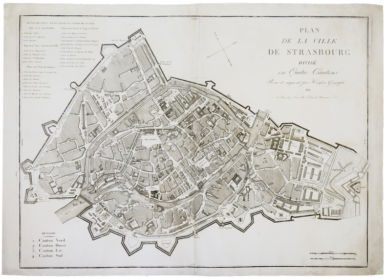
HERISSON (Eustache).
[STRASBOURG] Plan de la ville de Strasbourg divisé en quatre cantons.
Paris, Jean, 1836. 535 x 755 mm.
Referentie van de boekhandelaar : LBW-4455
|
|
|
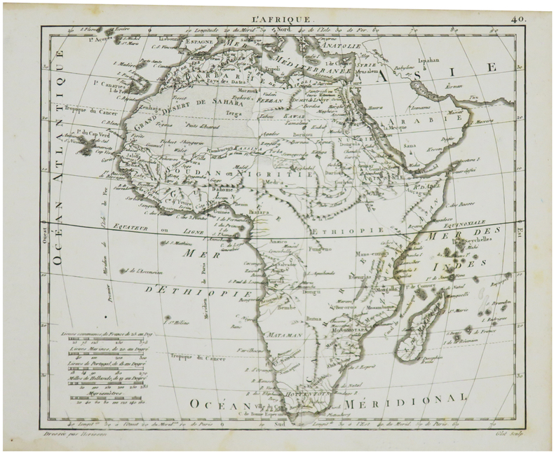
HERISSON (Eustache).
L'Afrique.
[1806]. 178 x 215 mm.
Referentie van de boekhandelaar : LBW024b9
|
|
|
Herkenhoff, Michael
Die Darstellung außereuropäischer Welten in Drucken deutscher Offizinen des 15. Jahrhunderts.
Berlin, Akademie-Verlag, 1996. 350 S. Mit Abb. 25 cm. OPp.
Referentie van de boekhandelaar : 95173

|
|
|
HERMANN (Louis) - Dressé par
Plan des communes de la Seine. Banlieue de Paris, région Est. Atlas-guide des 78 communes du département de la Seine.
Paris, Hachette, (1927). In-8, cartonnage de l'éditeur, 125 pp., plans en couleurs.
Referentie van de boekhandelaar : 26011

|
|
|
Hermann Kinder and Werner Hilgemann; translated by Ernest A. Menze; with maps designed by Harald and Ruth Bukor
The Penguin atlas of world history v. 1 Penguin reference books
Penguin Books N.A. Soft Cover. Fine. Page size: 2 v. Size: 18 cm New book size Penguin Books paperback
Referentie van de boekhandelaar : 2080202103703542
|
|
|
Hermann, John and B/w Illustrations and Maps
Motorcycle Journeys Through the Alps
Paperback. Fine. paperback
Referentie van de boekhandelaar : 37-16KC-MF7A
|
|
|
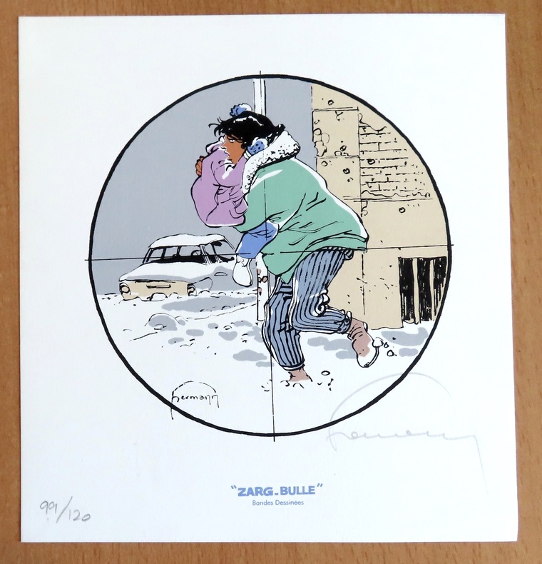
Hermann:
Ex libris Zarg-Bulle.
Zarg-bulle. 1852 Ex libris au format 18,5 x 20 cm. A l'état de neuf.
Referentie van de boekhandelaar : 24394
|
|
|
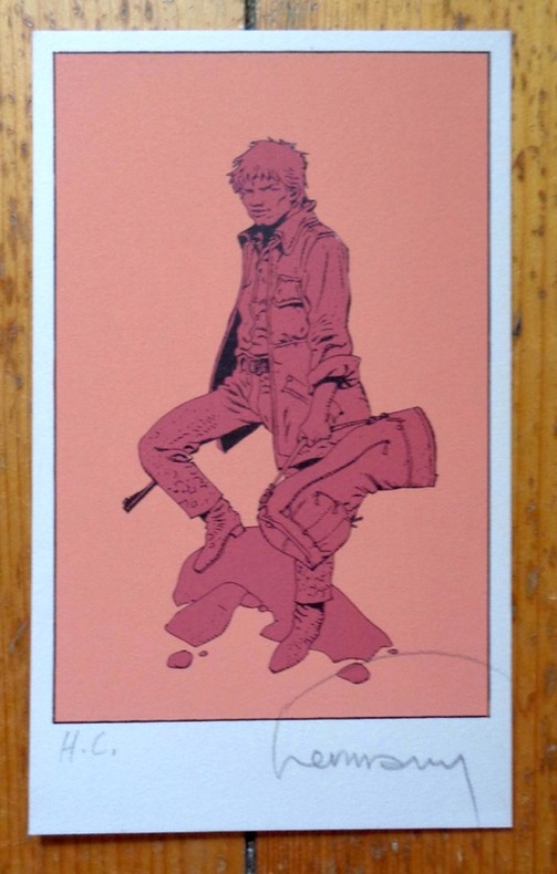
Hermann:
Petite sérigraphie signée.
Petite sérigraphie à l'état de neuf. Tirage nom mentionné, celle-ci marquée HC, signée par Hermann.
Referentie van de boekhandelaar : 5036
|
|
|
Hermann:
Voeux de la Tribune de Genève pour le 3e millénaire.
Tribune de Genève, 1999. Carte double au format fermé de 21 x 15 cm.
Referentie van de boekhandelaar : 24397

|
|
|
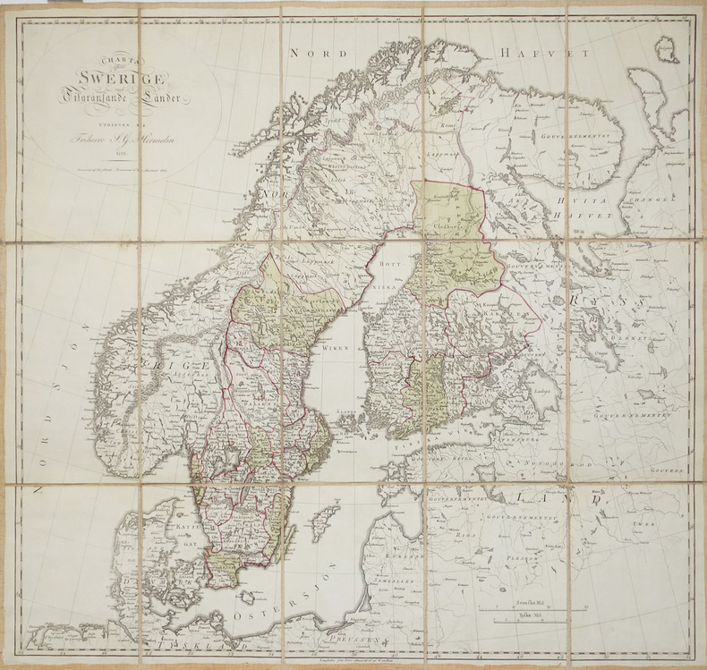
HERMELIN (Samuel Gustav).
[SUEDE] Charta öfwer Swerige med Tilgränsande Länder.
1797-1809. En 15 sections montées sur toile et pliées, formant une carte de 577 x 611 mm.
Referentie van de boekhandelaar : LBW-2930
|
|
|
HERNANDO RICA, Agustín.
Coleccionismo Cartográfico en el Siglo XVII. Ejemplares reunidos por Vincencio Juan de Lastanosa (1607-1681) y su significado.
Huesca, 2007. 4to. apaisado; 92 pp. Ilustraciones. Cubiertas originales.

|
|
|
HERNANDO RICA, Agustín.
La imagen de un país. Juan Bautista Labaña y su Mapa de Aragón (1610-1620).
Zaragoza, IFC, 1996. Folio; 158 pp., impresas a doble columna y 69 reproducciones de mapas. Cubiertas originales.

|
|
|
HERNÁNDEZ MILLARES, Jorge.
Atlas del Viejo Mundo.
México, Fondo de Cultura Económica, 1964. 4to. menor; 58 pp. y 42 mapas aparte. Enc. original en tela.

|
|
 De zoekresultaten per email ontvangen
 Zoekresultaten downloaden als PDF
 RSS feed


