|
HOCHMAN (Gene)
Encyclopedia of American Playing Cards. Part I. (un volume). Supplement to part I. (un volume). Part II. Featuring transformation cards and insert cards. (un volume). Part III. Featuring advertising, new suit signs, oddities, no revoke cards, teaching cards, novelties, college cards, union cards, fortune telling, tarots, price guide. (un volume). Part IV. Featuring standard cards through the years. (un volume). Part V. Complete index. (un volume). Part VI. Congratulations to the U.S. Playing Card Co. on their Centennial Year 1881-1981. (un volume).
chez l'auteur, 1976-1977-1979-1980-1982 0 7 volumes in-4°, (1) 55 ff., (10) ff., (2) 67 ff., (2) 74 ff., (2) 94 ff., 33 pp. et 42 pp., couvertures illustrées, dos collé pour 4 tomes, dos agrafé pour 3 tomes. (coupures en bordure de la couverture au tome I, deux couvertures décolorées). Nombreuses illustrations en noir & blanc dans le texte. Signature de l'auteur sur le tome VI. Exemplaire ronéoté. Ouvrage de référence sur les cartes à jouer. Rare complet.
Referentie van de boekhandelaar : 023809
|
|
|
Hochstrasser, Monique
The Art of the Regent
102 pages. A sumptuously presented selection of the art collection displayed in The Regent in Hong Kong. This is a collection carefully acquired not only for its aesthetic beauty but also for the elements of oriental symbolism that are represented. Includes fine examples of skilfully executed screens, lacquerware and embroidery. There are specimens of Chinese export wallpaper, and several nineteenth-century China Trade oil paintings. These became popular as artistic records of the cultural and trading contacts of their period and are now collector's items. The selection of maps traces the pattern of adventure and romantic trade and travel over the centuries. Finally, a group of contemporary works pleasantly relate the collection to modern artistic trends. All illustrations in vivid colour photography. Attractive maroon cloth boards bear imprint of Chinese characters upon front board and gilt roman lettering upon spine. Illustrated slipcase shows light edgewear and several nicks. Book and slipcase bear the aroma of moth balls. Book
|
|
|
HOCQUART Edouard-Auguste
Règles du jeu de bésigue à 2, 3 et 4 joueurs, et à 1, 2, 3 ou 4 jeux de cartes ; par M. X ...
Paris Théodore Moronval s.d. [vers1840] in-18 cart. moderne de papier brique, dos lisse, pièce de titre en long
Referentie van de boekhandelaar : 24871
|
|
|
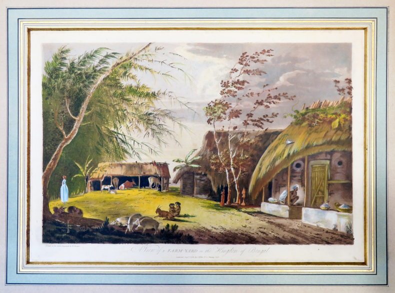
HODGES (William).
A View of a farm-yard in the kingdom of Bengal.
1787. 312 x 452 mm, sous passe-partout.
Referentie van de boekhandelaar : LBW-4003
|
|
|
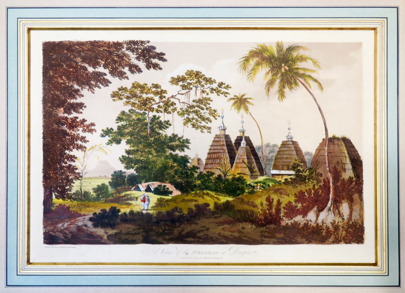
HODGES (William).
A View of the pagodas at Deogur.
1787. 313 x 453 mm, sous passe-partout.
Referentie van de boekhandelaar : LBW-4002
|
|
|
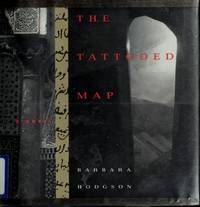
Hodgson, Barbara
The Tattooed Map
Vancouver BC: Raincoast Books 1995 Book. New. Hardcover. 1st Canadian Edition. A traveler to North Africa discovers that the mysterious marks on her hand have developed into a detailed and macabre maps spreading across her skin. We follow Lydia's journal entries as she becomes increasingly drawn into the mystery of the map traced over her body. When she disapears and her travelling partner Christopher takes up her journal the situation becomes even more puzzling - until the book's bizaare resolution. Profusely illustrated with ephemera documents maps pictures postcards to illuminate the story. Raincoast Books hardcover
Referentie van de boekhandelaar : 042711 ISBN : 1895714915 9781895714913
|
|
|
HOFFBAUER (Fédor).
La Cité entre le Pont Notre-Dame et le Pont au Change (1621).
Paris, Firmin-Didot et Cie, [1875-1882]. 237 x 300 mm.
Referentie van de boekhandelaar : LBW-5818

|
|
|
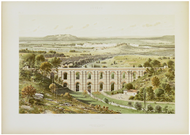
HOFFBAUER (Fédor).
Lutèce.
Paris, Firmin-Didot et Cie, [1875-1882]. 284 x 369 mm.
Referentie van de boekhandelaar : LBW-5821
|
|
|
Hoffman, Ludmila W.
Old Scapes, New Maps - A Training Program for Psychotherapy Supervisors
223 pages including two indeces. Author continues the pursuit of her long standing interest in the education and training of professional psychologists. A valuable resource for instructors of graduate programs in Psychology, Social Work, Psychiatric Nursing, Psychiatry and Counseling. Clean, crisp and unmarked with negligible wear. Excellent copy. Book
|
|
|
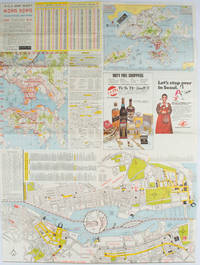
HOFFMAN, WALTER K. (CARTOGRAPHER).
A-O-A Map Sheet: Orientation Mini-maps.
Hong Kong.: Walter K. Hoffman. January/February1976. Coloured tourist map brochure of maps of Hong Kong printed both sides six maps in total folded. Brochure also includes advertisements currency rates. Minor tears along folds otherwise in good condition. Text in traditional Chinese English and Japanese. Sheet measures 58.2 x 43.4cm. Sheet includes 6 individual maps: Map of British Crown Colony of Hong Kong Map of the Urban Area with routes for public transportation Map of Tsimshatsui large scale street map Map of Central District large scale street map Map of Wanchai large scale street map Map of Causeway Bay large scale street map Map of Portuguese Overseas Province of Macau. On the maps of Central and TST the names of many businesses hotels etc are marked. . Walter K. Hoffman. unknown
Referentie van de boekhandelaar : 161881
|
|
|
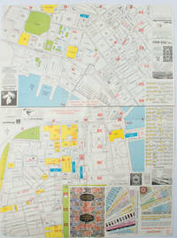
HOFFMAN, WALTER K. (CARTOGRAPHER).
A-O-A Map Sheet: Orientation Mini-maps.
Hong Kong.: A-O-A Ltd. June/July1977. Coloured tourist maps of Hong Kong printed both sides on a sheet folded. One general area map of Hong Kong and three detailed street maps featuring Kowloon Peninsula Tsimshatsui and Central District. Generally in very good condition text in traditional Chinese English and Japanese. Sheet measures 58.2 x 43cm. The tourist maps include currency rate tourist advice advertisements for foreign and local brands and shops e.g. A-O-A Gambling Handbook for Macau Duty Free shopping centres Chinese Arts & Crafts centres acupuncture clinic etc. The maps of Central and TST have the names of many hotels businesses post offices etc marked on them. . A-O-A Ltd. unknown
Referentie van de boekhandelaar : 161880
|
|
|
Hoffmann, Georg
2 Panoramen des Maderaner-Thales im Kanton Uri. Dazu ein Führer in die Gebirge des Maderaner-Thales. Verfasst von einigen Mitgliedern der Basler Section des schweizerischen Alpenclubs.
Basel, Felix Schneider, 1865. Textheft 54 S. u. 2 lithogr. Panoramen. 43 x 129 cm. + Wichtig: Für unsere Kunden in der EU erfolgt der Versand alle 14 Tage verzollt ab Deutschland / Postbank-Konto in Deutschland vorhanden +
Referentie van de boekhandelaar : 234BG
|
|
|
Hoffmann, Georg:
2 Panoramen des Maderaner-Thales im Kanton Uri. Dazu ein Führer in die Gebirge des Maderaner-Thales. Verfasst von einigen Mitgliedern der Basler Section des schweizerischen Alpenclubs.
Basel, Felix Schneider, 1865. Textheft 54 S. u. 2 lithogr. Panoramen. 43 x 129 cm.
Referentie van de boekhandelaar : 234BG
|
|
|
Hogarth David George; Bartholomew J. G. maps
THE PENETRATION OF ARABIA
New York: Frederick A. Stokes Company 1904. First American Edition. Hardcover. Octavo xiii 359 pages; VG-; bound in publisher's decorated green cloth gilt and black titling to spine; mild wear and rubbing primarily to head of spine and corners; bookplate to ffep; with 54 maps and plates; scarce; LJ consignment; shelved case 8 1/2. Also published in London the same year.;. 1336482. Shelved Dupont Bookstore. Frederick A. Stokes Company hardcover books
Referentie van de boekhandelaar : 1336482

|
|
|
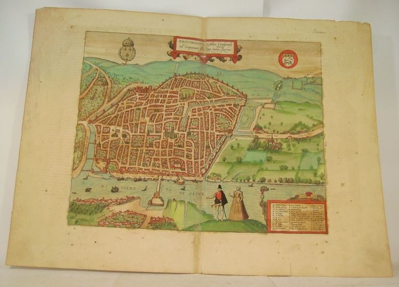
HOGENBERG (Franz).
RHOTOMAGUS Galliae Lugdunensis ad Sequanam Flu. Opp. vulgo Rouen.
Cologne, circa 1590. Gravure à belles marges (40 x 54 cm), rehaussée en couleurs avec texte en latin au dos.
Referentie van de boekhandelaar : 16633
|
|
|
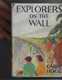
Hogg, Garry & Haigh, Molly (Illus) Tony (Add. Sketches & Maps)
Explorers on the Wall
London: Nelson. Very Good in Good dust jacket. 1948. Second Printing. Hardcover. A scarce title in the Explorers Awheel Series with an extremely scarce dustwrapper. The book is in green cloth boards with white lettering to spine. Maps to endpapers. A prize presentation inscription on blank endpaper ; The Explorers; 8vo 8" - 9" tall . Nelson, hardcover
Referentie van de boekhandelaar : 100515
|
|
|
Hohkirchen:
Hohkirchen. "Plan der Bataille, welche d. 14.October 1758 von der Kayserl. Königl. Ungarischen und Kön. Preussischen Armee bei Hohkirchen ohnweit Bauzen geliefert worden." Schlachtenplan von Hohkirchen. Kupferstich mit farbigen Truppenaufstellungen, Legende rechts. der Abbildung aus "Neues Kriegs-Theater", No. 20.
Format: 18 x 29,5 cm. *Leicht gebräunt, insgesamt gut erhalten. Landkarten de
|
|
|
Holborn Hajo; Maps Illustrator
History of Modern Germany: 1840-1945 v. 3
Alfred A Knopf 1969-01-01. Hardcover. Good. Hardcover and dust jacket. Good binding and cover. Underlining. DJ torn along spine. Bookplate. Alfred A Knopf hardcover
Referentie van de boekhandelaar : 2104200009 ISBN : 0413277003 9780413277008
|
|
|
HOLDER, Eric
Nouvelles du Nord
1984 - broché - Editions Le Dilettante - 1984 - In-12 (18 x 12 cm) broché avec agrafes, couverture à rabats - 23 pages - Avec une carte volante (plan Taride) du Xe arrondissement, possiblement signée par Eric Holder - Plaquette tirée à 333 exemplaires, sans justificatifs de tirage
Referentie van de boekhandelaar : 614

|
|
|
HOLLIER (Antoine Grégoire).
[CRIMÉE/MER d'AZOV] Vue générale de la mer d'Azoff & du détroit de Kertch.
Paris, Hollier, [circa 1856]. 236 x 282 mm.
Referentie van de boekhandelaar : LBW-6517

|
|
|
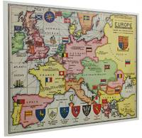
Holmes, Sherlock; Wolff, Dr. Julian [Maps]
THE SHERLOCK HOLMES MAP OF EUROPE: Greeting Card No. 4
London: Moore Batley Limited printer 1961. Single fold card with coloured map by Julian Wolff introductory commentary by Lord Donegall Christmas/New Year greeting and 'An incomplete gazetteer'. 16.2 cm. x 20.3 cm.; within blank envelope edges lightly chipped and browned; Moore Batley Limited printer London 1961. De Waal World Bibliography #4820. 'Julian Wolff who became head of the Baker Street Irregulars in 1960 created an attractive and imaginative series of canonical locations some of which originally appeared in Edgar W. Smith's 'Baker Street and Beyond' other in 'The Baker Street Journal'. In 1984 they were collected and printed as 'The Sherlockian Atlas'. They depict London England Europe the United States Dartmoor and other significant sites including a layout of the interior of 221B Baker Street. In the 1960s Wolff also hand-coloured a set for Lord Donegall editor of 'The Sherlock Holmes Journal' who had them printed as Christmas Cards. These cards are now highly collectible as are the original maps.' The Sherlock Holmes Miscellany Roger Johnson Jean Upton. Moore Batley Limited (printer) unknown
Referentie van de boekhandelaar : 089419
|
|
|
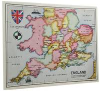
Holmes, Sherlock; Wolff, Dr. Julian [Maps]
THE SHERLOCK HOLMES MAP OF ENGLAND: Greeting Card No. 7
London: Graphis Press Limited printer 1964. Single fold card with coloured map by Julian Wolff introductory commentary by Lord Donegall Christmas/New Year greeting and 'An incomplete gazetteer'. 16.2 cm. x 20.3 cm.; within blank envelope edges lightly chipped and browned; Graphis Press Limited printer London 1964. De Waal World Bibliography #4820. 'Julian Wolff who became head of the Baker Street Irregulars in 1960 created an attractive and imaginative series of canonical locations some of which originally appeared in Edgar W. Smith's 'Baker Street and Beyond' other in 'The Baker Street Journal'. In 1984 they were collected and printed as 'The Sherlockian Atlas'. They depict London England Europe the United States Dartmoor and other significant sites including a layout of the interior of 221B Baker Street. In the 1960s Wolff also hand-coloured a set for Lord Donegall editor of 'The Sherlock Holmes Journal' who had them printed as Christmas Cards. These cards are now highly collectible as are the original maps.' The Sherlock Holmes Miscellany Roger Johnson Jean Upton. Graphis Press Limited (printer) unknown
Referentie van de boekhandelaar : 141900
|
|
|
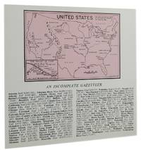
Holmes, Sherlock; Wolff, Dr. Julian [Maps]
THE SHERLOCK HOLMES MAP OF THE UNITED STATES: Greeting Card No. 9
London: N 1966. Double fold card with coloured illustration across inside panels 'Operation House-moving from Baker Street to Chateau de Lucens Switzerland' with key to contents commentary by Lord Donegall brief "The compliments of the season" The Blue Carbuncle message and a smaller map of the United Stated by Julian Wolff above 'An incomplete gazetteer'; 14.9 cm. x 15.9 cm.; within large blank envelope edges lightly browned; London 1967. De Waal World Bibliography #4820. 'Julian Wolff who became head of the Baker Street Irregulars in 1960 created an attractive and imaginative series of canonical locations some of which originally appeared in Edgar W. Smith's 'Baker Street and Beyond' other in 'The Baker Street Journal'. In 1984 they were collected and printed as 'The Sherlockian Atlas'. They depict London England Europe the United States Dartmoor and other significant sites including a layout of the interior of 221B Baker Street. In the 1960s Wolff also hand-coloured a set for Lord Donegall editor of 'The Sherlock Holmes Journal' who had them printed as Christmas Cards. These cards are now highly collectible as are the original maps.' The Sherlock Holmes Miscellany Roger Johnson Jean Upton. N unknown
Referentie van de boekhandelaar : 141901
|
|
|
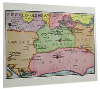
Holmes, Sherlock; Wolff, Dr. Julian [Maps]
THE SHERLOCK HOLMES MAP OF ENGLISH COUNTIES: Greeting Card No. 10
London: Graphis Press Limited printer 1967. Single fold card with coloured map by Julian Wolff 'It is full of old houses' introductory commentary by Lord Donegall Christmas/New Year greeting and 'An incomplete gazetteer'; 16.2 cm. x 20.3 cm.; within blank envelope lightly browned top and bottom edges chipped; Graphis Press Limited printer London 1967. De Waal World Bibliography #4820. 'Julian Wolff who became head of the Baker Street Irregulars in 1960 created an attractive and imaginative series of canonical locations some of which originally appeared in Edgar W. Smith's 'Baker Street and Beyond' other in 'The Baker Street Journal'. In 1984 they were collected and printed as 'The Sherlockian Atlas'. They depict London England Europe the United States Dartmoor and other significant sites including a layout of the interior of 221B Baker Street. In the 1960s Wolff also hand-coloured a set for Lord Donegall editor of 'The Sherlock Holmes Journal' who had them printed as Christmas Cards. These cards are now highly collectible as are the original maps.' The Sherlock Holmes Miscellany Roger Johnson Jean Upton. Graphis Press Limited (printer) unknown
Referentie van de boekhandelaar : 141902
|
|
|
Holstein
[Karte von] Herzogth. Holstein und Lauenburg, Fürstenth. Lübeck, Fr. Städte Hamburg und Lübeck nebst Amt Bergedorf. Grenzkolorierter Stahlstich, gestoch. von K. Fuchs.
Hildburghausen, Bibliographisches Institut, [ca. 1865]. Bildgröße: 31 x 38 cm. Im Mahagonirahmen, unter Mattglas (38,5 x 47 cm).
Referentie van de boekhandelaar : 97900

|
|
|
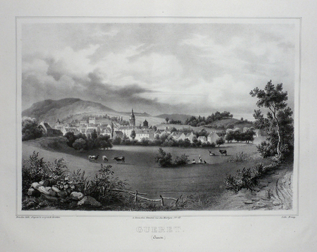
HOLSTEIN;
GUERET (Creuse).
Paris Benard circa 1850 226 x 287 mm.
Referentie van de boekhandelaar : LBW03d65
|
|
|
HOLSTEN - MERCATOR, G. / HONDIUS.
Holsatia ducatus. Per Gerardum Mercatorum privilegio.
(Amsterdam ca. 1607). 35,3x48 cm. Kobberstukket kort over Holsten. Ukoloreret. Velbevaret. På bagsiden latisnk tekst (pp.89-90) Daniae III Tabula, In qua Slesvicensis Ducatus, & Holsatia.
Referentie van de boekhandelaar : 25258
|
|
|
HOLSTEN - MERCATOR, G. / HONDIUS.
Holsatia ducatus. Per Gerardum Mercatorum privilegio.
(Amsterdam ca. 1607). 35,3x48 cm. Kobberstukket kort over Holsten. Ukoloreret. Velbevaret. På bagsiden latisnk tekst (pp.89-90) Daniae III Tabula, In qua Slesvicensis Ducatus, & Holsatia.
|
|
|
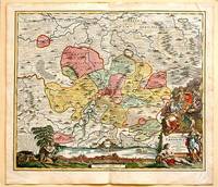
Holzer - Reilly, Franz Johann Joseph von
Special-Karte von dem Oestreichischen u. Osmanischen Koenigreiche Kroatien. Teilkolorierte Kupferstichkarte (No. 2) aus "Schauplatz der fünf Theile der Welt".
Wien, Reilly, ca. 1789. 22 x 29 cm (Blattgröße 24 x 32 cm).
Referentie van de boekhandelaar : 110616

|
|
|
Holzman, Jacquelin; McQuarrie, John; Tosh, Rosalind
Ottawa, Then and Now
No marks or inscriptions. A lovely clean very tight copy with bright unmarked boards and no bumping to corners. Dust jacket not price clipped or marked or torn with slight creasing to edges and traces of storage. 208pp. Ottawa from her birth to the present day in very well captioned photographs. Scarce in the UK.

|
|
|
HOMANN JOHANN BAPTIST.
Nova Territori Erfordien in Suas Prefecturas.
Nuremberg.: Johann Baptist Homann. 1717. A beautifully engraved hand coloured map of North East Germany showing the area around Erfurt in detail. In the centre of the map is a small plan of Erfurt which is also shown as a panoramic view at the foot of the map and titled 'St. Petersburg'. An elaborate decorative title cartouche in the lower right corner depicts allegorical figures surrounded by the produce of the land including sheaves of wheat; a beehive; and a cornucopia of fruits. Cherubs holding a coat of arms float up from the scene on the right while on the lower left a centaur sits meditatively beneath a pine tree amongst slaughtered cattle. Physical features of the area are illustrated and farming areas shown by fields which criss-cross across the map. A clear dark impression the work of an outstanding German cartographer who in 1715 was appointed as imperial geographer by Emperor Charles VI. This map also includes "Schwan See" Swan Lake under a town of the same name which has since disappeared. Hand coloured two very minor splits at upper and lower edges on centre fold and not affecting engraved area a handsome map 54 x 61.5 cm. . [Johann Baptist Homann.] unknown
Referentie van de boekhandelaar : 61880
|
|
|
HOMANN (Héritiers de).
[PANAMA] Portus Pulchri in Isthmo Panamensi - Scenographia Portus Pulchri.
[Nuremberg], Homann Héritiers, 1740. 480 x 282 mm.
Referentie van de boekhandelaar : LBW-5884

|
|
|
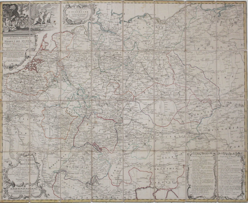
HOMANN (Héritiers de).
[POSTES] Nouvelle carte géographique des postes d'Allemagne - Neue und vollstændige Postkarte durch ganz Deutschland.
Nuremberg, Héritiers de Homann, 1786. En 32 sections montées sur toile et pliées, formant une carte de 776 x 968 mm.
Referentie van de boekhandelaar : LBW-4318
|
|
|
HOMANN (Héritiers de);
[CROATIE/BOSNIE/SERBIE] Regnum Bosniae, una cum finitimis Croatiae, Dalmatiae, Slavoniae, Hung. et Serviae partibus - Regni Serviae pars, una cum finitimis Valachiae & Bulgariae.
Nuremberg vers 1740 En 4 feuilles jointes de 605 mm x 1,11 m, dont une partie mobile de 310 x 185 mm.
Referentie van de boekhandelaar : LBW-1799

|
|
|
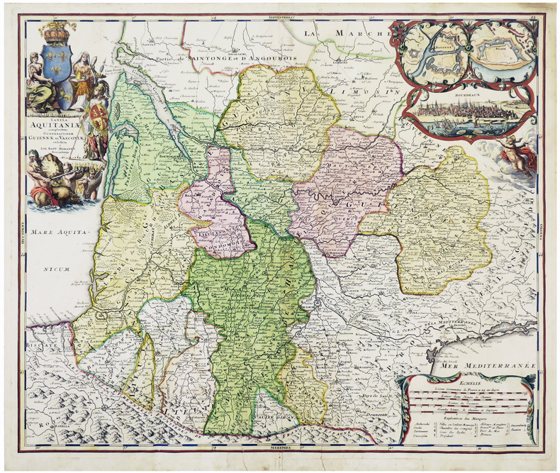
HOMANN (Johann Baptist).
[AQUITAINE] Tabula Aquitaniæ complectens gubernationem Guiennæ et Vasconiæ exhibita.
Nuremberg, [circa 1720]. 478 x 570 mm.
Referentie van de boekhandelaar : LBW-6109
|
|
|
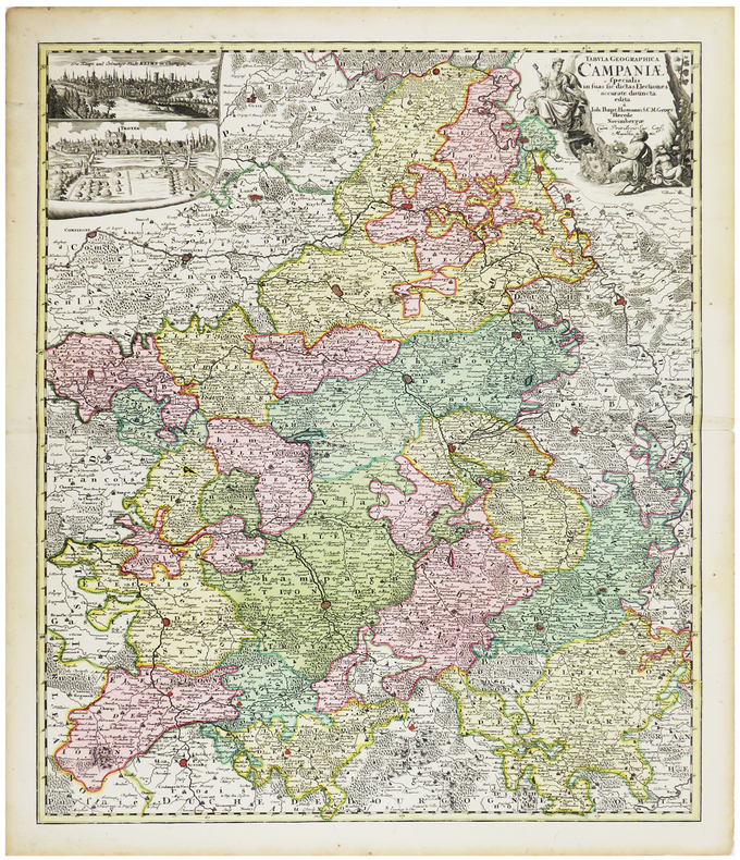
HOMANN (Johann Baptist).
[CHAMPAGNE] Tabula geographica specialis in suas sic dictas electiones accurate distincta edita.
Nuremberg, [circa 1720]. 574 x 488 mm.
Referentie van de boekhandelaar : LBW-6259
|
|
|
HOMANN (Johann Baptist).
[PAVILLONS] Flaggen aller Seefahrenden Potenzen und Nationen in der gantzen Weldt.
Nuremberg, [circa 1720]. 495 x 587 mm.
Referentie van de boekhandelaar : LBW-4462

|
|
|
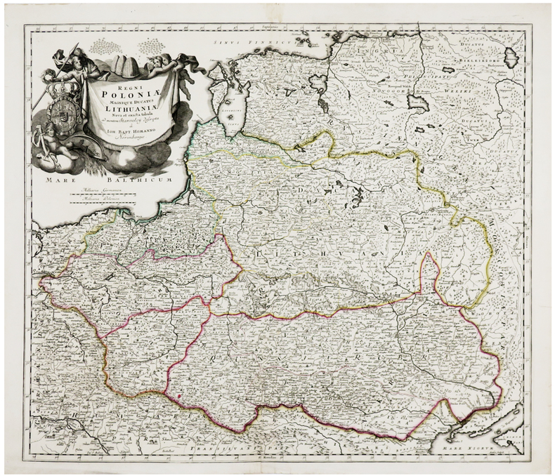
HOMANN (Johann Baptist).
[POLOGNE/LITUANIE] Regni Poloniæ magnique Ducatus Lithuaniæ.
Nuremberg, [circa 1710]. 492 x 568 mm.
Referentie van de boekhandelaar : LBW-6237
|
|
|
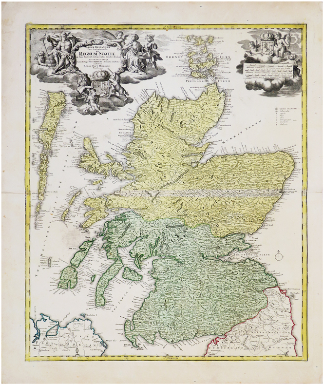
HOMANN (Johann Baptist).
[ÉCOSSE] Magnæ Britanniæ pars septentrionalis qua regnum Scotiæ.
Nuremberg, [circa 1730] 574 x 478 mm.
Referentie van de boekhandelaar : LBW-6539
|
|
|
HOMANN (Johann Baptist);
[METZ] Accurata rapraesentatio ichnographica urbis episcopalis in Ducatu Lotharingiae, dictae Metae.
Nuremberg 1739 470 x 556 mm.
Referentie van de boekhandelaar : LBW-403

|
|
|
HOMANN (Successeurs)
ATLAS NOVUS REIPUBLICAE HELVETICAE XX MAPPIS COMPOSITUS SUMTIBUS HOMANNIANIS HEREDIBUS.
1769 Nuremberg, 1769. 33x52,5 cm. Recueil de 20 grandes cartes de la Suisse sur double pages, en couleurs ! Augmenté d'une carte de Neuchâtel et Valangin dressée en 1778. Reliure de la fin du XVIIIème siècle ou du début du XIXème siècle en demi-basane à petits coins. Plats recouverts de papier beige moucheté. Dos lisse orné de bandes dorées. Titre sur pièce de couleur orangée. Petites traces d'usage sur la reliure et papier très légèrement bruni par endroit, sinon ouvrage en excellent état et complet, ce qui est exceptionnel !
Referentie van de boekhandelaar : 1564
|
|
|
HOMANN Eredi Johannes Baptiste (1730 - 1813)
Neue Welt Karte
Carta geografica de l mondo inserita nell'atlante degli eredi della tipografia Homann. Dal punto di vista cartografico la mappa presenta diverse innovazioni ed aggiornamenti, soprattutto nel Pacifico dove sono mostrate le scoperte di Cook del 1770. I Grandi Laghi si presentano come un unico enorme specchio d'acqua e la California ha una forma strana, con la Baja che sembra quasi un'isola. L'Australia comprende diversi toponimi sulla costa orientale, frutto delle scoperte di Cook nel 1770. Tuttavia, l'isola di Van Diemens è ancora mostrata collegata alla terraferma. Sono disegnate le rotte di diverse esplorazioni della fine del XVIII secolo. Johann Baptist Homann è stato un geografo e cartografo tedesco; nel 1702 fondò la sua casa editrice. Homann acquisì fama come uno dei principali cartografi tedeschi, e nel 1715 fu nominato geografo imperiale dall'imperatore Carlo VI. Nello stesso anno fu anche nominato membro dell'Accademia Prussiana delle Scienze a Berlino. Nel 1716 Homann pubblicò il suo capolavoro Grosser Atlas ueber die ganze Welt. Numerose mappe furono redatte in collaborazione con l'incisore Christoph Weigel. Homann morì a Norimberga nel 1724. Gli successe suo figlio Johann Christoph (1703-1730). L'azienda continuò dopo la sua morte come azienda degli eredi Homann, gestita da Johann Michael Franz e Johann Georg Ebersberger. Dopo successivi cambiamenti nella gestione, l'azienda si sciolse nel 1852. Incisione in rame, finemente colorata a mano, in ottimo stato di conservazione. This interesting world map presents some curious cartography, given the date of the map. The Great Lakes are shown as one huge body of water and California is strangely shaped with the Baja nearly appearing as an island. Australia includes several place names on the eastern coast, which resulted from Cook's discoveries in 1770. However, Van Diemens Land is still shown connected to the mainland. The tracks of several late 18th century expeditions are shown. Color key and German text panel below the hemispheres. Johann Baptist Homann was a German geographer and cartographer; in 1702 he founded his own publishing house. Homann acquired renown as a leading German cartographer, and in 1715 was appointed Imperial Geographer by Emperor Charles VI. In the same year he was also named a member of the Prussian Academy of Sciences in Berlin. In 1716 Homann published his masterpiece Grosser Atlas ueber die ganze Welt; numerous maps were drawn up in cooperation with the engraver Christoph Weigel the Elder. Homann died in Nuremberg in 1724 and was succeeded by his son Johann Christoph (1703-1730). The company carried on upon his death as Homann heirs company, managed by Johann Michael Franz and Johann Georg Ebersberger. After subsequent changes in management the company folded in 1852. Etching with fine later hand colour, very good condition.

|
|
|
HOMANN Eredi Johannes Baptiste (1730 - 1813)
Urbis Romae Ichnographia à Leonardo Bufalino…
Pianta geometrica con elevazione, pubblicata a Norimberga dalla tipografia degli eredi di Johannes Baptiste Homann nel 1755. Si tratta di una rielaborazione, senza alcun aggiornamento, dell'importante rilievo di Leonardo Bufalini (1551), riportato in voga da Giovan Battista Nolli nel 1748. La legenda di 307 rimandi in latino è ripesa proprio dalla riduzione di Nolli, e ne dimostra la diretta derivazione. Tuttavia la pianta degli eredi Homann, stampata su quattro fogli e quindi di dimensioni maggiori, risulta decisamente più leggibile. "La pianta di Roma di Leonardo Bufalini è la prima rappresentazione coerente della città e la più importante raffigurazione ortogonale fino alla pianta grande di Giambattista Nolli (1748). Bufalini si occupò di tutte le fasi della sua realizzazione, dal rilievo all’incisione, impiegando un lungo tempo: sette anni, secondo Onofrio Panvinio, venti secondo l’editore Antonio Trevisi. La Pianta di Roma fu stampata presso il tipografo Antonio Blado il 26 maggio 1551 a Roma, con privilegio decennale della Repubblica di Venezia e la dedica a Carlo V e a papa Giulio III. Si tratta di un’opera monumentale: una xilografia in dodici fogli e quattro strisce laterali. Nessun esemplare della prima edizione è noto; se ne conoscono solo tre della seconda edizione, pubblicata sempre a Roma, dall’editore Antonio Trevisi da Lecce, due conservati alla Biblioteca Vaticana (di cui uno incompleto) e un terzo alla British Library di Londra. Sebbene la pianta sia basata su rilievi effettuati dall’autore con grande perizia, non mancano elementi di fantasia: molti monumenti antichi sono stati aggiunti, completati e ricostruiti liberamente. Del resto, è lo stesso autore a sottolineare questa ambivalenza, dichiarando di voler presentare “la città che oggi è abitata…aggiungendo la [città] antica, un tempo sovrana del mondo…” Bufalini incluse nella pianta anche un autoritratto in cui è raffigurato con in mano il compasso a due punte, mentre a sinistra sono rappresentati i suoi strumenti di lavoro, fra cui la squadra e la bussola nautica. Per una più completa trattazione degli strumenti di misurazione utilizzati e per l’accuratezza della pianta bufaliniana si rimanda ai numerosi studi pubblicati. La fonte primaria utilizzata da Bufalini è la Roma antica di Bartolomeo Marliano, inserita nella sua Urbis Romae Topographia, che ha lo stesso orientamento e la stessa precisione nei particolari. Fin dalla sua pubblicazione nel 1551, la pianta del Bufalini esercitò una notevole influenza sulle successive piante della città fino al 1748, anno in cui Giambattista Nolli ne pubblicò una copia ridotta insieme alla sua pianta grande, che si impose quale nuovo modello" (cfr. B/R p. 2372). Johann Baptist Homann è stato un geografo e cartografo tedesco; nel 1702 fondò la sua casa editrice. Homann acquisì fama come uno dei principali cartografi tedeschi, e nel 1715 fu nominato geografo imperiale dall'imperatore Carlo VI. Nello stesso anno fu anche nominato membro dell'Accademia Prussiana delle Scienze a Berlino. Nel 1716 Homann pubblicò il suo capolavoro Grosser Atlas ueber die ganze Welt. Numerose mappe furono redatte in collaborazione con l'incisore Christoph Weigel. Homann morì a Norimberga nel 1724. Gli successe suo figlio Johann Christoph (1703-1730). L'azienda continuò dopo la sua morte come azienda degli eredi Homann, gestita da Johann Michael Franz e Johann Georg Ebersberger. Dopo successivi cambiamenti nella gestione, l'azienda si sciolse nel 1852. Acquaforte, 4 lastre di dimensioni 495x365 mm ciascuna, stampate su altrettanti fogli di carta vergata coeva, con margini e ancora da unire, in perfetto stato di conservazione. Bibliografia Huelsen (1915), n. 3; Scaccia Scarafoni (1939), n. 136; Marigliani (2007): n. 32. Per la pianta del Bufalini: Bifolco/Ronca (2018), Cartografia e topografia italiana del XVI secolo, pp. 2372-73, tav. 1221. Geometric plan with elevation, published in Nuremberg by the printing hose of Johannes Baptiste Homann's heirs in 1755. It is a reworking, without any updating, of the important relief by Leonardo Bufalini (1551), brought back by Giovan Battista Nolli in 1748. The key-legend of 307 references in Latin is taken from Nolli's reduction, and demonstrates its direct derivation. However, the map of the Homann heirs, printed on four sheets and therefore larger in size, is much more clear. Leonardo Bufalini's map of Rome is the first coherent representation of the city and the most important orthogonal representation up to the large plan by Giambattista Nolli (1748). Bufalini took care of all the phases of its realization, from relief to engraving, using a long time: seven years, according to Onofrio Panvinio, twenty according to the publisher Antonio Trevisi. The Map of Rome was printed at the typographer Antonio Blado on May 26, 1551 in Rome, with the ten-year privilege of the Republic of Venice and dedicates it to Charles V and Pope Julius III. It is a monumental work: a woodcut in twelve sheets and four lateral strips. Although the map is based on reliefs made by the author, there is no lack of elements of fantasy: many ancient monuments have been added, completed and rebuilt freely. The primary source used by Bufalini is Bartolomeo Marliano's ancient Rome, inserted in his Urbis Romae Topographia, which has the same orientation and the same precision in detail. Since its publication in 1551, Bufalini's map exerted a notable influence on the subsequent plans of the city until 1748, the year in which Giambattista Nolli published a reduced copy together with his large plan, which became the new model. Johann Baptist Homann was a German geographer and cartographer; in 1702 he founded his own publishing house. Homann acquired renown as a leading German cartographer, and in 1715 was appointed Imperial Geographer by Emperor Charles VI. In the same year he was also named a member of the Prussian Academy of Sciences in Berlin. In 1716 Homann published his masterpiece Grosser Atlas ueber die ganze Welt; numerous maps were drawn up in cooperation with the engraver Christoph Weigel the Elder. Homann died in Nuremberg in 1724 and was succeeded by his son Johann Christoph (1703-1730). The company carried on upon his death as Homann heirs company, managed by Johann Michael Franz and Johann Georg Ebersberger. After subsequent changes in management the company folded in 1852. Etching, 4 plates 495x365 mm each, printed on as many sheets of coeval laid paper, with margins and yet to be joined, in perfect condition. Literature Huelsen (1915), no. 3; Scaccia Scarafoni (1939), n. 136; Marigliani (2007): n. 32.

|
|
|
HOMANN Johann Baptist (1663 - 1724)
Urbis Romae Veteris ac Modernae accurata delineatio…
Pianta a proiezione mista, orientata con il nord a sinistra, ripresa dalla pianta di Giovan Battista Falda. "E' una copia della pianta di Johannes De Ram senza alcun aggiornamento. In alto a destra lo stemma di Clemente XI (1700-1721). Sebbene stampata intorno al 1720 raffigura la città alla fine del Seicento, come avviene per un cospicuo nucleo di piante derivate dal Falda ed edite nel Nord Europa in questo periodo, nelle quali tutti i cambiamneti si concentrano nei nuovi apparati decorativi e non nel contenuto della pianta stessa" (cfr. Marigliani p. 229, n. 133). La carta fu realizzata da Homann per il suo Grosser Atlas. Johann Baptist Homann è stato un geografo e cartografo tedesco; nel 1702 fondò la sua casa editrice. Homann acquisì fama come uno dei principali cartografi tedeschi, e nel 1715 fu nominato geografo imperiale dall'imperatore Carlo VI. Nello stesso anno fu anche nominato membro dell'Accademia Prussiana delle Scienze a Berlino. Nel 1716 Homann pubblicò il suo capolavoro Grosser Atlas ueber die ganze Welt. Numerose mappe furono redatte in collaborazione con l'incisore Christoph Weigel. Homann morì a Norimberga nel 1724. Gli successe suo figlio Johann Christoph (1703-1730). L'azienda continuò dopo la sua morte come azienda degli eredi Homann, gestita da Johann Michael Franz e Johann Georg Ebersberger. Dopo successivi cambiamenti nella gestione, l'azienda si sciolse nel 1852. Acquaforte, bella coloritura coeva editoriale, in buono stato di conservazione. Mixed projection map, oriented with north on the left, based on the map of Giovan Battista Falda. It is a close copy of the map of Johannes De Ram without any update. In the upper right corner is the coat of arms of Clemente XI (1700-1721). Although printed around 1720 it depicts the city at the end of the seventeenth century, as is the case for a large group of maps derived from Falda and published in Northern Europe in this period, in which all the changes are concentrated in the new decorative apparatus and not in the content of the map itself (see Marigliani p. 229, n. 133). The map was made by Homann for his Grosser Atlas. Johann Baptist Homann was a German geographer and cartographer; in 1702 he founded his own publishing house. Homann acquired renown as a leading German cartographer, and in 1715 was appointed Imperial Geographer by Emperor Charles VI. In the same year he was also named a member of the Prussian Academy of Sciences in Berlin. In 1716 Homann published his masterpiece Grosser Atlas ueber die ganze Welt; numerous maps were drawn up in cooperation with the engraver Christoph Weigel the Elder. Homann died in Nuremberg in 1724 and was succeeded by his son Johann Christoph (1703-1730). The company carried on upon his death as Homann heirs company, managed by Johann Michael Franz and Johann Georg Ebersberger. After subsequent changes in management the company folded in 1852. Etching with fine original colour, good condition. Huelsen (1915): n. 124a; Scaccia Scarafoni (1939): n. 210; C. Marigliani, "Le Piante di Roma delle collezioni private", tav. 133.

|
|
|
Homann, Baptist Johannes:
Systema solare et planetarium ex hypothesi Copernicana secundum elegantissimas illustrissimi quondam Hugenij deductiones novissime collectum & exhibitum. Altkolorierte Kupferstichkarte aus Doppelmayr, Atlas novus coelestis.
48,5 x 56 cm. Darstellung des Sonnensystems und Sternbilder im Tierkreis. Bis an die Randlinien beschnitten und alt aufgezogen. Am linken Seitenrand und an den der rechten unteren Ecke mit insgesamt 3 kleineren Randfehlstellen. - Versand erfolgt ausgerahmt und ohne Rahmen. Bücher de
|
|
|
Homann, Joh. Bapt.:
Saxoniae Tractus Ducatum Magdeburgensem cum suo Circulo Salico. Kupferstichkarte mit Grenz- und Flächenkolorit.
47,5 x 54 cm (Blattgröße 48,5 x 55,5 cm). *Zeigt das Gebiet von Braunschweig und Goslar bis Potsdam und Torgau und Osterburg bis Leipzig. Oben links mit einer Gesamtansicht von Magdeburg (9 x 22,5 cm) in Kupferstich. Unten links Kartusche mit allegorischen Darstellungen. - Sauber und sehr gut erhalten. Landkarten de
|
|
|
Homann, Joh[ann] Bapt[ista
Prospect und Grund-Riss der Kayserl. Residenz Stadt Wien mit negst anligender Gegend und Neuen Linien umb die Vorstadt (mit einer Ansicht von Wien: Prospekt der Kayserl. Residenz Stadt Wien, wie solche von Mitternacht anzusehen).
Nürnberg, Homann (um 1720). altkol. Kupferstichplan, Gesamtmaß: 61x 53 cm, Ansicht: 58x49 cm, in 24 Teilstücke zerschnitten u. auf Leinwand aufgezog., kartenmäßig gefalt., Leinen an den Rändern etw. fransig, auf Rückseite zwei Felder beschriftet. Grundriss der Innenstadt mit den angrenzenden Vorstädten Leopoldstadt, Alsergrund, Josefstadt, Neubau, Margareten, Wieden und Erdberg sowie der noch unregulierten Donau und deren Auen; in re. ob. Ecke Kartusche mit Erklärung von Häusern, Kirchen etc.; unt
Referentie van de boekhandelaar : KART0098

|
|
|
Homann, Johann Baptist
Circulus Saxoniae Inferioris in omnes suos Status et Principatus (um 1720.) [Altkolorierter Kupferstich, gerahmt / handcoloured copper engraving, framed].
o.J. [3 Warenabbildungen] (Johann Baptist Homann, geb. 20.03.1664 in Oberkammlach, heute Unterallgäu, gest. 01.07.1724 in Nürnberg, deutscher Kar
Referentie van de boekhandelaar : 66112CB

|
|
|
Homann, Johann Baptist
Landgraviatus Hassiae Inferioris nova Tabula in qua praecipue ditionis Hasso-Casselense et Comitatus Waldeck. Altkolorierter Kupferstich mit 2 unkolor. figürlichen Kartuschen.
Nürnberg, [ca. 1720]. Darstellung: 48,5 x 57,5 cm. Unter altem Schrägschnittpassepartout.
Referentie van de boekhandelaar : 86051

|
|
|
Homann, Johann Baptist
Mosellae Fluminis Tabula Specialis in qua Archiepiscopatus et Electoratus Trevirensis in suas Praefecturas accuratè divisus ut et Eyfaliae Tractus osten ditur Sumtibus Ioh. Baptistae Homanni Noribergae. Teilkolorierter Kupferstich mit unkol. Kartusche.
Nürnberg, [ca. 1720. 49 x 57,5 cm.
Referentie van de boekhandelaar : 81226

|
|
 De zoekresultaten per email ontvangen
 Zoekresultaten downloaden als PDF
 RSS feed


