|
SVERIGE I KART -
Generalstabens karta öfver Sverige norra delen skala 1:200000 utgifven af Rikets allmänna kartverk.
(Stockholm, ca. 1890). Folio-oblong. Orig. hldrbd. med rygforgyldning. Ryg med lidt skrammer. Med et oversigtskort og et blad med Teckenförklaring samt alle 66 farvelitograferede kort, som opmålt indtil udgivelse (ca. 1890).
Referentie van de boekhandelaar : 35718
|
|
|
LÜDDECKE, R.
Afrika in 6 Blättern. Mit einem vollständigen Namenverzeichnis.
Gotha, Justus Perthes, o.J. (Ca. 1890). Small folio. (33x22 cm.). Orig. full cloth, gilt lettering with title on frontcover. Small tears to backstrip, edges with light wear. 23 pp. and Africa-map 100x85,5 cm. coloured and folded, mounted on cloth. The map in fine condition.
Referentie van de boekhandelaar : 36348
|
|
|
ST. PETERSBURG - COLLINS, WILLIAM.
St. Petersburg.
London, Glasgow & Edinburgh ca. 1870. Coloured lithograph showing a bird's eye view of the city. 22 x 28 cm. Framed and matted.
Referentie van de boekhandelaar : 38865
|
|
|
BALSLEV, SVEND og HANS EJNER JENSEN.
Landmåling og landmålere. Danmarks økonomiske opmåling. 2 bd.
Kbhvn., Den danske Landinspektørforening, 1975. Orig. halvlæder. 333 s. Illustr. + Mappe i folioformat med 14 farvereproduktioner.
Referentie van de boekhandelaar : 38906
|
|
|
MANUSCRIPT MAP.
Slaget wed Zornsdorff den 25de Augusti 1758.
No place and date. (probably Denmark late 18th century). Handpainted map in ink and watercolour. 25 x 41 cm. In silver frame. Slightly foxed overall.
Referentie van de boekhandelaar : 39179
|
|
|
MANUSCRIPT MAP.
Grund Tegning af Fästningen og Castellet i Leystad.
No place and date (probably Denmark, late 18th century). Hand painted map in ink and water colour. 26,5 x 41 cm. Silver frame. Overall slightly foxed.
Referentie van de boekhandelaar : 39180
|
|
|
GROSS, A.G. FREIHERRN von.
Historisch-militärisches Handbuch für die Kriegsgeschichte der Jahre 1792 bis 1808, enthaltend eine genaue Uebersicht aller Feldzüge und Landungen, welche in diesem Zeitraume Statt gefunden haben. Mit einem topographisch-militairischen Atlasses von 17...
Amsterdam, Kunst- und Industrie - Comptoir, 1808. 8vo. and folio. Textvol. bound in modest hcalf., spine worn. Atlas-volume in contemp. boards with printed title from orig frontwrapper pasted on frontboard, and later clothbacking. Corners bumped. Stamps on titlepage and old owners name. First and last leaves a little brownspotted, scattered brownspots. Atlas-volume with titlepage on which content of maps. 17 large folded engraved maps, mostly folded and in double-folio, with outline and position colouring. Maps uncut and clean.
Referentie van de boekhandelaar : 40611
|
|
|
PROBST GEORG BALTHASAR.
Pyramides Aegyptiae, miraculum mundi tertium. Les Pyramides de l’Egypte, troisiéme miracle du Monde. I Pyramidi d’Egitto, il terzo miracolo del Mondo. Die Egyptischen Pyramiden, dritte Wunderwerk der Welt.
Augsburg, G.B. Probst, ca. 1780. Engraved and hand coloured vue d'optique. 30 x 40 cm. Mirrored titel with small tear not affecting text. Colours slightly faded, margins a little foxed.
Referentie van de boekhandelaar : 41637
|
|
|
"HAMBURG -
Plan von Hamburg.
Hamburg bei G. W. Niemeyer, Ca. 1840. Lithographed map ""Plan von Hamburg"", Steindruck von J. Guntrum, Verlag von G.W. Niemeyer. (33x50 cm.). Folded inserted in orig. cloth-covers, gilt.
Referentie van de boekhandelaar : 42211
|
|
|
"CHINA - VAN LOON, (JAN).
Imperii Sinarum Nova Descriptio. Auctore Joh. van Loon.
Amsterdam, Gerardi Valk et Petri Schenk, n.d. (around 1694). 46,5 x 52 cm. Engraved map China in orig. handcolouring. Showing all the Chinese provinces, Korea and the island of Formosa in the south. Ships in the sea and cartouche with Chinese costumes. A small rupture in a border due to etching from the colour used (no loss). Left margin with a small tear, no loss. Right, very broad, margin with a tear, not reaching the image.
Referentie van de boekhandelaar : 42217
|
|
|
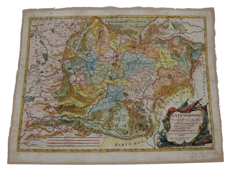
"TRANSYLVANIA - VIGNOLA, GIACOMO CANTELLA da.
La Transilvania. Diuisa su l'Esemplare delle Carte migliori e con la direzione delle piu recenti notizie nelle sue Cinque Nationi e subdiuisa ne suoi Comitati, e principali Quartieri..
Roma, Gio. Giacomo de Rossi, 1686. (42,5 x 57 cm.). Engraved map in contemp. full handcolouring. Large rococco-cartouche. Cartouche and margins with some light browning.
Referentie van de boekhandelaar : 42611
|
|
|
"DENMARK - WILLIAM BERRY.
The Kingdom of Denmark subdivided into its Principall Provinces.
London, William Berry, (1689). Ca 58x88 cm. Frame and under plexiglass. Large engraved map of Denmark in contemp.outline colouring. Perhaps the largest engraved map of Denmark from the 17th century.
Referentie van de boekhandelaar : 42652
|
|
|
FYN - (PONTOPPIDAN, ERIC).
Generalem hanc Fioniæ Tabulam Geographicam...ut et Provinciæ Fionensis ac Prefecturar: Othon: Dalum: etc: supremo Præfecto. officiosissime inscribit A.H. Godiche.
(København), A.H. Godiche, 1766. 46,5 x 55,5 cm. Kobberstukket kort over Fyn og omgivende vande med Tåsinge og en del af Langeland. Stor fin rokokkokartouche. Nederste del af venstre margin lidt tæt beskåret, dog uden tab af billede. Ren og frisk, på svært skrivepapir.
Referentie van de boekhandelaar : 43462
|
|
|
SJÆLLAND - (PONTOPPIDAN, ERIC).
Generalem et prorsus Novam Siælandiæ....officiosissime inscribit E.P. (Eric Pontoppidan).
(Kiøbenhavn, Godiche, 1767). 46,5 x 55,5 cm. Kobberstukket kort over Sjælland med stor fin rokokkokartouche. Lidt tæt beskåret, et par små revner ved venstre margin repareret.
Referentie van de boekhandelaar : 43464
|
|
|
THE HOLY LAND - SANSON, NICHOLAS.
Iudaea seu Terra Sancta quæ Hebraraeorum sive Israelitarum in suas duodecim Tribus divisa Regnis Iuda et Israel.... Gulielmi Sanson....Hubertus Iallot.
Amsterdam, Huguetan & Mortier, 1691. 56x85 cm. Large engraved map of Terra Sancta with original colours in outline. With two large engraved cartouches. Small repairs to lower part of centerfold.
Referentie van de boekhandelaar : 43500
|
|
|
NORGE - JAN JANSSONIUS.
Regni Norvegiae. Nova et Accurata descriptio.
Amsterdam omkr. 1664. 42,5x53. Tæt skåret indtil pladenranden, men intet tab. Kobberstukket og i samtidig håndkolorering. Kartouche med skovarbejdere, kompasrose, skibe i søen.orienteret med øst øverst.
Referentie van de boekhandelaar : 44306
|
|
|
THE AMERICAS - MATTHAEUS MERIAN.
America noviter delineata (in the cartouche). Septentrionalissimas Americae partes Groenlandiam puta, Islandiam at adjacentes, quod Americae tabulae commodé comprehendi non potuerit, peculariari hac tabella Spectatoribus exhibendas duximus. (At upper ...
Without place, (Basel ca. 1650). 30x36 cm. Fine engraved map of North and South America from Terra del Fuego, Terra Australis Incognita and the Magellan Strait in the south to the unmapped regions in the north. A small map of the known parts og Greenland in inset. Outer left shows the coasts regions of Spain and Africa. Ships and whales in the see. Signed M. Merian fecit (lower right). Clean and fine, broad margins, uncoloured.
Referentie van de boekhandelaar : 44316
|
|
|
AUSTRALIA - JAMES WYLD.
Map of South Australia, New South Wales, Van Diemens Land, and Settled parts of Australia. Respectfully dedicated to Major Sir T.L. Mitchell.
(London), JAs (James) Wyld, (around 1850). (62,5 x 94 cm.). Engraved map, with original outline colourung.. A few small tears in margins, not affecting image.
Referentie van de boekhandelaar : 44333
|
|
|
"BROUWER, L. E. J. [LUITZEN EGBERTUS JAN].
Beweis der Invarianz der Dimensionenzahl. - [THE FOUNDATION OF ALGEBRAIC TOPOLOGY]
Leipzig, B.G. Teubner, 1911. 8vo. Original printed wrappers, no backstrip and a small nick to front wrapper. In ""Mathematische Annalen. Begründet durch Alfred Clebsch und Carl Neumann. 70. Band. 2. Heft."" Entire issue offered. Internally very fine and clean. [Brouwer:] Pp. 161-65. [Entire issue: Pp. 161-296].
Referentie van de boekhandelaar : 44532

|
|
|
"DANMARKSKORT - BLAEU, WILLEM & J.
Dania Regnum.
(Amsterdam, ca. 1662). 43x52,5 cm. Kobberstukket generalkort over Danmark i original håndkolorering. Velbevaret og og med brede marginer. Med det danske rigsvåben og stor dekorativ kartouche flankeret af vildmændene, begge i helkolorering. Fint frisk eksemplar af dette dekorative Danmarkskort.
Referentie van de boekhandelaar : 45039
|
|
|
"KØBENHAVN - PONTOPPIDAN, ERIC.
Den Kongel: Residentz Stad Kiöbenhafn i Grundtegning Ao MDCCLXIV.
(Kiöbenhavn, 1764). 54x43 cm. Kobberstukket grundplan af København indenfor Voldene, visende bebyggelsen i 1764. Med spor efter foldning, men iøvrigt ren og frisk, trykt på svært skrivepapir
Referentie van de boekhandelaar : 45755
|
|
|
"PARIS - PHILIPPE BUACHE.
Exposé d'un Plan hydrographique de la Ville de Paris.
(Paris, L'Imprimerie Royale, 1745). 4to. Without wrappers. Extracted from ""Mémoires de l'Academie des Sciences. Année 1742"". Pp. 371-378 and 3 folded engraved maps (1. Premier Plan Cours de la Seine dans l'etendue de Paris (20x23 cm) - 2. Second Plan ou l'on voit les Rues dont on à les pentes....les diverses Quartiers de Paris (19,5x22 cm) - 3. Coupe de la Ville de Pars... Plan des Rues... (22,5x30 cm)). Clean and fine.
Referentie van de boekhandelaar : 46589
|
|
|
"PETERMANN, A. (HRSG.). - A WORLD OF EXPLORATORY EXPEDITIONS.
Mittheilugen aus Justus Perthe's Geographischer Anstalt über wichtige neue Erforschungen auf dem Gebiete der Geographie. (1.-) 20. Bd. (Lacking vol. 14 (1868) & 1870).
Gotha, Julius Perthes, 1855-1874. 4to. Bound in 18 contemp. hcalf, some wear to the first 10 vols., some a bit rubbed. Some scattered brownspots to the first volumes. Gilt spines. Wear to top of spines. With a huge amount of original maps, plates, profiles etc., lithographed and engraved, large and folded and mainly in colour. This set does not include the ""Ergänzungsbände"".
Referentie van de boekhandelaar : 46629
|
|
|
PETERMANN, A. (HRSG.).
Mittheilugen aus Justus Perthe's Geographischer Anstalt über wichtige neue Erforschungen auf dem Gebiete der Geographie. 1858 (= Bd. 4 der Reihe).
Gotha, Julius Perthes, 1858. 4to. Contemp, hcalf. Gilt spine. A small stamp to titlepage. VIII,596 pp. and 20, partly folded, lithographed maps and plans. Text as well as maps fine and clean.
Referentie van de boekhandelaar : 46631
|
|
|
PETERMANN, A. (HRSG.).
Mittheilugen aus Justus Perthe's Geographischer Anstalt über wichtige neue Erforschungen auf dem Gebiete der Geographie. 1867 (= Bd. 13 der Reihe).
Gotha, Julius Perthes, 1867. 4to. Contemp, hcalf. Gilt spine. Spine somewhat rubbed. A small stamp to titlepage. VI,470 pp. and 19, partly folded, lithographed maps and plans. Textleaves with some browning and scattered brownspots. Maps clean.
Referentie van de boekhandelaar : 46634
|
|
|
PETERMANN, A. (HRSG.).
Mittheilugen aus Justus Perthe's Geographischer Anstalt über wichtige neue Erforschungen auf dem Gebiete der Geographie. 23. Bd.
Gotha, Julius Perthes, 1877. 4to. Later hcloth. Spine gilt. XII,476 pp. and 23, partly folded, lithographed maps and plans. Internally clean.
Referentie van de boekhandelaar : 46640

|
|
|
PETERMANN, A. (HRSG.).
Mittheilugen aus Justus Perthe's Geographischer Anstalt über wichtige neue Erforschungen auf dem Gebiete der Geographie. 1860 (= Bd. 6 der Reihe). (+) 3 Ergänzungshefte. (1. A. Vibe: Küsten und Meer Norwegens. 24 pp., 1 chromolithographed plate (with ...
Gotha, Julius Perthes, 1860. 4to. Contemp, hcalf. Gilt spine. A small stamp to titlepage. X,490 pp. and 19, partly folded, lithographed maps and plans. Internally clean. + Ergänzungshäfte.
Referentie van de boekhandelaar : 46641
|
|
|
PETERMANN, A. (HRSG.).
Mittheilugen aus Justus Perthe's Geographischer Anstalt über wichtige neue Erforschungen auf dem Gebiete der Geographie. 1861 (= Bd. 7 der Reihe). (+) 3 Ergänzungshefte. (1. G. Lejean: Ethnographie de la Turque D'Europe. Ethnographie der Europäisch...
Gotha, Julius Perthes, 1861. 4to. Contemp, hcalf. Gilt spine. A small stamp to titlepage. VIII,482 pp. and 16, partly folded, lithographed maps and plans. Internally clean. + Ergänzungshäfte.
Referentie van de boekhandelaar : 46642
|
|
|
"RUGE, SOPHUS.
Die Entwicklung der Karthographie von Amerika bis 1570. Festschrift zur 400jährigen Feier der Entdeckung Amerikas. Mit 32 Kärtchen auf 2 Tafeln.
Gotha, Julius Perthes, 1892. 4to. No wrappers. (4),85 pp. and 32 maps on 2 large folded plates.
Referentie van de boekhandelaar : 46766
|
|
|
"BAUMANN, OSCAR.
Die kartographischen Ergebnisse d. Massai-Expedition des Deutschen Antisklaverei-Comités. Mit Ergänzung durch die Aufnahmen von G.A. Fischer, W. Werther und A. Spring und unter Mitwirkung von Bruno Hassenstein und L. Ambronn.
Gotha, Julius Perthes, 1894. 4to. No wrappers. (2),56 pp. and 4 large folded maps.
Referentie van de boekhandelaar : 46802

|
|
|
KATTEGAT OG BÆLTERNE - J. ROBIJN (JACOB ROBYN).
Pascaert Vant Schager-Rack en de Belt. van d'Paternoster tetin de Oest Zee. Op Nieuws Verbetert door J. Robyn.
(Amsterdam), 1696. 52x59,5 cm. Kobberstukket og håndkoloreret søkort visende Bælterne mellem Østjylland, Fyn, Sjælland, Lolland og Falster, Sydsverige, Rü Bornholm, Nordtyskland m.v. Med det danske rigsvåben i nederste højre hjørne" heri dedikation til Cornelis Tromp, den danske og hollandske flådes admiral. Den store kartouche i øverste venstre hjørne viser scener fra folkelivet og brydning af kalksten fra Møn eller Stevns. Fin reparation i højre margin.
Referentie van de boekhandelaar : 47333

|
|
|
MIDTJYLLAND - MERCATOR, G.(GERHARD).
Iutia Septentrionalis.
(Amsterdam, 1595-1623). 29x40 cm. Kobberstukket kort over Nørrejylland, egnene omkring Limfjorden, vendsyssel i nord og til Horsens i syd samt Samsø. Samtidig håndkolorering. Bagsiden med latinsk tekst. Barokkartouche.
Referentie van de boekhandelaar : 47336
|
|
|
KATTEGAT OG SUNDET - DECRES, C. (DENIS DUC DE DECRES).
Carte réduite du Cattegat comprenant La Côte de Suede depuis Marstrand jusqu'a Landscrone. La côte du Jutland depuis le Cap Skagen jusqu'à l'Entrée des Belts a la Cô septentrionale de l'Ile de Séelande d'apres les Observations et les Cartes Danoi...
(Paris), Au Depot général dee la Marine, 1813. 85x59 cm. Kobberstukket kort i stort format over Kattegat og den nordlige del af Øresund med København i syd, den svenske vestkyst fra Tjørnø i nord til Barsebæk i syd. Jyllands østkyst fra Skagen i nord til Gylling Næs i syd med øerne Anholt, Læsø, Samsø, Endelave m.v. Lidt rifter i højre marginsom ikke når bileldfladen. Fint rent eksemplar.
Referentie van de boekhandelaar : 47340
|
|
|
"KATTEGAT - KEULEN, JOHANNES VAN.
Paskaert vant' Schager-Rak. Soo't by de Oost-vaerende Zee- Luyden gemeenlyk bezylt wort, door Voogt- Geometra.
Amsterda, Ioannis Van Keulen, ca. 1680. 51,5x60 cm. Kobberstukket søkort over Kattegat med gengivelse af Østjylland fra Skagen til Horsens Fjord, Anholt, Læsø og Samsø, den svenske vestkyst fra Maesterland i nord til Landskrona i syd. Nordsjælland med Øresund fra Helsingør i nord til lidt syd for Hven. Kortet "" ligger ned"" med nord til venstre.
Referentie van de boekhandelaar : 47341
|
|
|
"DANMARKSKORT - WILLIAM BERRY.
The Kingdom of Denmark subdivided into its Principall Provinces.
London, William Berry, (1689). 56x87 cm. Large engraved map of Denmark in original outline colouring. Perhaps the largest engraved map of Denmark from the 17th century.
Referentie van de boekhandelaar : 47354
|
|
|
"PORCACCHI DA CASTIGLIONE, THOMASO.
L'isole piu famose del Mondo. Arettino e intagliate da Girolamo Porro Padovano. Con l'aggiunta di molte isole all' ill.re s. conte Georgio Trivltio. - [THE CULMINATION OF THE ""BOOK OF ISLANDS""]
Venetia [Venice], apresso gli heredi di S. Gagliani, 1590. [Colophon: In Vintia, appresso Giorgio Angelieri, a instantia de gli heredi di Simon Gagliani de Karera, 1590]. Small folio. 18th century (ab. 1780-90) half vellum with gilt leather title label to spine. Corners a bit bumped and title label a bit worn, otherwise nice and tight. A very nice copy, on thick, crisp paper. A few quires browned and brownspotted, and some occasional lighter browning. Four leaves with a marginal worm-tract, far from affecting text. Beautiful engraved title-page, consisting of a wide architectural border illustrated with large figures, putti, globes, and various symbols. Beautiful large woodcut initials and head- and tail-pieces. 47 half-page engraved maps in the text (by Porro, of islands and continents), excellent, crisp impressions. Large woodcut device to colophon. (12) ff., 201, (1) pp.
Referentie van de boekhandelaar : 47728
|
|
|
"DANMARKSKORT - FR. DE WIT.
Regni Daniae Accuratissima delineatio.
Amsterdam, Ca. 1675). 44,5x54,5 cm. Under glas i fin sølv/guldramme. Kobberstukket og håndkoloreret kort over Danmark.
Referentie van de boekhandelaar : 48161
|
|
|
KØBENHAVN - EM. BÆRENTZEN (ILLUSTR.).
Prospect af Kjöbenhavn i Aaret 1520
(København, omkr. 1850). (Ca.20x30 cm.). Tonet litografi af Bærentzen set mod Nørreport. Lettere brunplettet.
Referentie van de boekhandelaar : 48233
|
|
|
"MERCATOR, G. - HONDIUS, J.
Warwicum, Northampton, Huntingdon, Cantabrigia, Suffolcia, Oxonium, Buckinghamia, Bedfordia etc.
(Amsterdam, ca. 1610). (19x25,5 cm.). Engraved map of the south east of England in old handcolouring with The Isle of Wright, London, Cambridge etc. etc. Letterpress headline outside engraving ""Angleterre"". Coloured in full. Right and left sides shaved.
Referentie van de boekhandelaar : 48922
|
|
|
SPEED, JOHN.
John Speed's England. A coloured Facsimile of the Maps and text from the Theatre of the Empire of Great Britaine. First Edtion, 1611.
London, Phoenix House Limited, (1953-54). Folio. 4 orig. hcloth, all in orig. slicase. Fine and clean. Text and fine facsimile-maps in colour.
Referentie van de boekhandelaar : 49146
|
|
|
"PERTHES, JUSTUS.
Atlas Général, composé de trente quatre Cartes coloriées et gravées sur Cuivre.
Gota, Justus Perthes, 1873. Large 8vo. Orig. hcalf, but nicely rebacked with buckram. Double-page title-page with ""Table des Matiéres"" and 34 double-page engraved maps with outline-colouring. 8Numb. 1-20 + a,b,c numb). Maps clean, some brownspots seen on verso of maps.
Referentie van de boekhandelaar : 49323
|
|
|
"DUPERREY, L.I. - MAPPING THE GILBERT ISLANDS.
Notice sur la Configuration de l'équateur magnétique, conclue des observations faites dans la campagne de la Corvette la Coquille.
(Paris, Crochard, 1830). No wrappers. In: ""Annales de Chimie, ou Recueil de Mémoires concernant la Chemie"" 2e Series, Tome 45, Cahier 3. Pp. 337-448 a. 1 engraved map (entire issue offered). Duperrey's paper: pp. 371-386. Text with scattered brownspots. Map with a small closed tear in lower left corner, otherwise fine.The map: ""Configuration de LÉquateur Magnétique.... faites dans la campagne de la Corvette de S.M. la Coquille, pendent les années 1822, 1823, 1824 et 1825. Par M.L.I. Duperrey Commandant de L'Expedition"" Left: Dressée par L.I. Duperrey, en 1829. Right corner: Gravée par Ambroise Tardieu. (29x80 cm. (the map-sheet))
Referentie van de boekhandelaar : 49607
|
|
|
LONDON - CRUCHLEY, (GEORGE FREDERICK).
Cruchley's New Plan of London Shewing all the New and Intended Improvements to the Present Time. Published May 1st 1827 - A new Edition, Improved to 1st January 1833.
London, Cruchley map Seller, (1833). (42,5 x 60 cm.) Fine engraved and handcoloured map of London. Updated to 1833. The street- indexes engraved in the margins. The map is in fine condition, plain and not folded.
Referentie van de boekhandelaar : 49661

|
|
|
DANMARKSKORT - J.B. HOMANN.
Regni Daniae in quo sunt Ducatus Holsatia et Slesvicum Insulae Danicae, Provinciae Iutia Scania Blekingia... Nova Tabula... Iohann Hübneri.
Nürnberg, (ca. 1740). Kobberstukket Danmarkskort med samtidig håndkolorereing, 49,5x59 cm. Visende også Skåne, Halland og Blekinge og i øverste højre hjørne stor kartouche med rigsvåbnet. Kortet er indrammet under glas i fin ramme af brun birkefiner.
Referentie van de boekhandelaar : 49793
|
|
|
"SEUTTER, GEORG MATTHÄUS. - SCANDINAVIA AND THE BALTIC.
Synopsis Plagae septemtrionalis sive Sueciae Daniae et Norvegiae Regn.
(Wien, ca. 1730) (49x58,5 cm.). Kobberstukket, håndkoloreet Skandinavienskort med Estland, Letland, Litauen og det vestlige Rusland. Velbevaret indrammet under glas i fin ramme af brun birketræsfiner. Håndkolorereingen en smule svag.
Referentie van de boekhandelaar : 49794
|
|
|
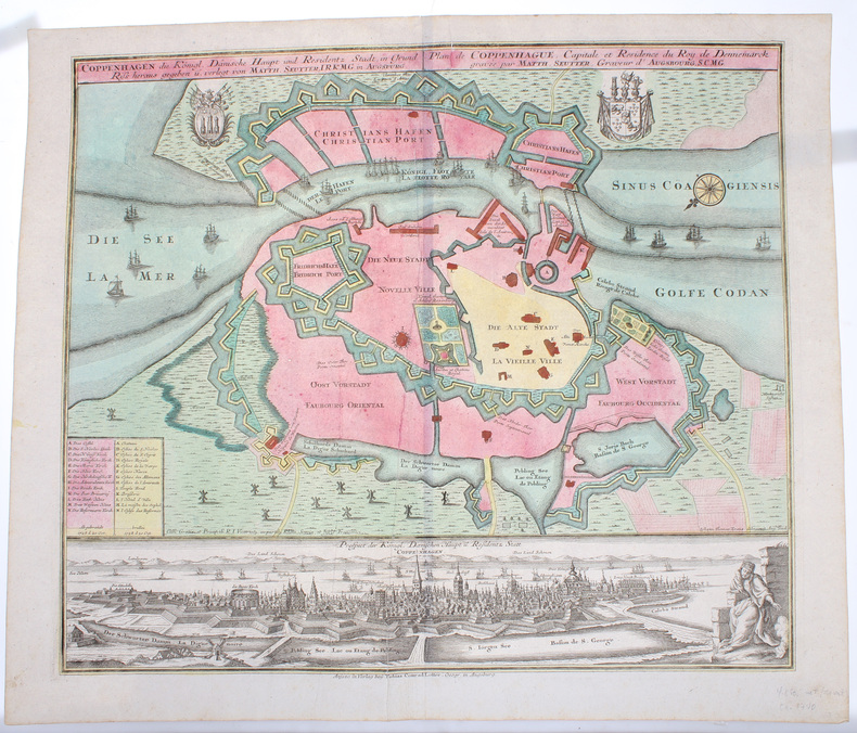
KØBENHAVN - COPENHAGEN. - MATTHIAS SEUTTER.
Coppenhagen die Königl. Dänische Hauptstadt und Residentz Stadt, in Grund Riss.
Augsburg, Verlag bey Tobias Conrad Lotter, (Ca. 1740). 50,5x59,5 cm. Kobberstukket plan over København visende bydelene lige efter den store brand 1728 og med den afbrændte del markeret. Fuld samtidig håndkolorering. Nederst på siden er der et detailleret prospekt af København, ukoloreret. Med våbenskjolde, kompasroser og skibe i søen.
Referentie van de boekhandelaar : 50395
|
|
|
"HOMANN, JOHANN BAPTIST.
Atlas Minor L. Selectorum Tabularum Homanni. Kleiner Atlas von Fünffzig Auserlesenen Homanns=Land=Karten, Nach Anleitung der neuesten Erd=Beschreibere, verbessert und eingerichtet...(= Printed title) - (Engraved title:) Atlas Novus Terrarum Orbis Impe... - [AN EARLY COMPLETE HOMANN-ATLAS]
Nürnberg, Homannischen Officin, n.date (maps ca 1720-39). Large folio. 54,5x32 cm. Contemporary, probably original, limp full calf with flap (""portmanteau""). (Only 4 maps with dating: 2 with 1732, 1728 and 1739).Cover with blind-tooled frames inside which a crowned monogram and the number 50 (= number of plates). Binding worn at edges, covers and back somewhat rubbed. Flap torn and partly with an old repair. Fine allegorical engraved hand-coloured title, printed title with Index (these 2 leaves strengthened in lower margin, no loss of image), and all 49 engraved maps, all in fine original hand-colouring and in double-folio. In excellent condition, with large cartouches (cartouches uncoloured). A few maps with insignificant small tears in folding. The title-page engraved by Michael Rössler, pointing to an early issue of the atlas, and before the publishing house had its name changed to Homann Erben (from 1730).
Referentie van de boekhandelaar : 51181
|
|
|
TÅSINGE, LANGELAND, ALS, ÆRØ - H. SKANKE.
Kort over den Sydlige Deel af Fyen tilligemed det tilgrænsende Stykke af hertugdømmet Schleswig saavel øerne Langeland, Taasinge, Ærøe, Als og mellemliggende smaae Øer under det Kongl: Videnskabernes Societets Direction ved rigtig Landmaaling optaget,...
(København), 1783. Kobberstukket kort over Øerne etc. 53x88 cm. Med stor kobberstukket kartouche. Tegnet for Videnskabernes Selskab af H. Skanke 1783. Kortet er her originalt opdelt i 21 felter, opklæbet på lærred og foldet som rejsekort. Indlagt i marmoreret foderal.
Referentie van de boekhandelaar : 51528

|
|
|
"DAHLBERG, E.I.
Repræsentatio Accubitus Regum Sueciæ Daniæq Fridericiburgi d. 3. 4. et 5. Mart. 1658.
(Nürnberg, 1696). 30,5 x 38,5 cm. Kobberstikket afbilder forhandlingerne på Fredensborg i riddersalen mellem Frederik III, Sophie Amalie og Carl X Gustav m.fl. Talrige personer tilstede, heraf 16 navngivne i den kobberstukne tekst.
Referentie van de boekhandelaar : 51664
|
|
|
"RIETER & SENN.
Tvende Siællandske Bønder nærvejs Kiøbenhavn og Kiøgekanten i deres almindelige Dragt.
(København, 1805). Originalt håndkoloreret kobberstik. (21 x 14,5 cm.). Indrammet i ""sølvramme"" (29 x 21 cm.). Frisk eksemplar.
Referentie van de boekhandelaar : 52215
|
|
 De zoekresultaten per email ontvangen
 Zoekresultaten downloaden als PDF
 RSS feed


