ARABIAN GULF; PERSIA; GREAT GAMEBiblio.com
2127 risultati
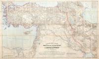
1899rif. 155664Dehra Dún India & Berlin: Photozincographed at the Office of the Trigonometrical Branch Survey of India & Dietrich Reimer 1899-1904. Remarkable assemblage of three important and superbly detailed maps A rare opportunity to acquire three exceptionally impressive and uncommon maps together forming the finest contemporary cartographic overview of the Great Game's central theatre. Spanning from the Mediterranean to Afghanistan and from the Caspian to Sir Baniyas Island they present a striking synoptic view of the region at a moment of intense strategic interest. All three share the same provenance each bearing the distinguished bookplate of the officers' mess library of the 85th Foot later part of The King's Light Infantry. Likely acquired as a group by an officer attuned to imperial affairs in the run-up to or immediate aftermath of the 1907 Anglo-Russian Convention they reflect the period's effort as Hopkirk notes to resolve regional rivalries and curb Germany's eastward ambitions. The Persia map is a landmark Survey of India production and the most comprehensive rendering of the region then available incorporating the latest British and Russian surveys and reconnoitres. Only 300 copies of this August 1904 issue were printed and institutional locations are limited to the British Library Deutsche Nationalbibliothek and Sächsische Landesbibliothek. The impressive wall map of Afghanistan June 1901 produced under Strahan and Gore and executed at the Frontier Drawing Office under Colonel R. A. Wahab is equally rare with copies recorded only at the British Library Wisconsin and the Bayerische Staatsbibliothek. Its authority rests on extensive British and Russian sources including work by Robertson Trotter Sykes Ney Elias and the Afghan Boundary Commission. These maps exemplify the Survey of India's exacting standards during the era of photozincographic production when officers were required to vet every detail under magnification. Kiepert's map of the Ottoman Empire complements the two Survey of India sheets representing the best contemporary mapping of a region Britain could not itself survey. Kiepert one of the foremost scholarly cartographers of the 19th century travelled widely in Ottoman territories producing clear and remarkably accurate maps that remain valuable records of the period. This map is comparatively well represented institutionally with around 17 holdings recorded in Europe the US and the UK. Persia: scale 1:1013760 six-sheet coloured map divided into four linen-backed quadrants each measuring approx. 976 x 963 mm when assembled measuring 1952 x 1926 mm North West North East South West South East each backed with Nonpareil pattern marbled paper each section dissected into 20; Afghanistan: scale 1:1013760 coloured map dissected into 45 sections linen backed measuring approx. 1035 x 1640 mm; Turkey: scale 1:1500000 coloured map dissected into 65 sections linen backed measuring approx. 1016 x 1700 mm; together with the "Apercu general" measuring 412 x 570 mm showing the administrative division of the same area intended to accompany the map; dissected into 10 sections linen backed. Each map housed in the original dull purple morocco-grain cloth case Stanford's printed label to front. Cases a little worn with some loss of fabric light toning to maps otherwise in excellent condition. Cases a little worn with some loss of fabric occasional light toning to maps otherwise in excellent condition. Kourosh Ahmadi Islands and International Politics in the Persian Gulf: Abu Musa and the Tunbs in Strategic Perspective 2008; Kyle J. Gardner The Frontier Complex: Geopolitics and the Making of the Indo-China Border 1846-1962 2021; Peter Hopkirk The Great Game: On Secret Service in High Asia 1992. hardcover
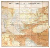
1881rif. 149774St Petersburg: Cartographic Institute of the Military-Topographic Department of the General Staff 1881. The cartographic climax of the "great game" Second edition significantly improved from the first edition 1877 to incorporate the latest military intelligence from field surveys. This magisterial work of "great game" cartography was presented at Russia's Tashkent military headquarters to the daring French explorer Stanislas Benoist-Méchin during his epic 1881-3 overland journey from Beijing to Europe. We have traced no other copies. A presentation inscription on the verso of the map reads in French "To Mr Baron Benoist-Méchin from Generals Kouropatkine and Levaschew October 1882 Tashkent." Benoist-Méchin 1854-1923 began travelling the world as a young man and then served as the French cultural attaché in Tokyo 1880-1. In 1881 he decided to return to Europe via the daring route through Central Asia. Leaving Beijing on 15 September with his regular travelling companion Comte Humbert Adrien de Mailly-Chalon 1853-1921 he journeyed through Manchuria and across Russian Siberia. In 1882 having reached Kashgar they received permission to cross Russian Turkestan spending six weeks in Tashkent as the honoured guests of General Mikhail Tchernayev the architect of Russian's expansion across Central Asia General Aleksey Nikolayevich Kuropatkin 1848-1925 and the aforementioned General Levaschov likely the artillery officer Vladimir Levaschov 1834-1898. After reaching Samarkand they travelled in extreme cold through Bukhara and via Khiva to Tehran reaching Moscow in October 1883 where they were accorded a hero's welcome. Their descriptions of this feat of exploration were published in 1885 in the Bulletin de la Société de géographie. This map was made for the use of the Russian military high command in St Petersburg and in the Turkestan Military District which had been established in the 1860s amid the occupation of Tashkent and Bokhara and dates from a period following the Second Anglo-Afghan War and the Battle of Geok Tepe when tensions were at their height. It encompasses almost the entire playing surface of the "great game" extending east-west from Xinjiang and Tibet to the Caspian Sea and Afghanistan and north-south from Siberia to northern India. Unparalleled in terms of accuracy and detail it names every city town and village and the legend has entries for such features as fortifications railways mail and caravan roads and mines. Spot heights are given in feet and deserts are marked with a light red pattern. It is much improved on the first edition which had only 48 panels and did not extend as far south. Chromolithograph map 195 x 200 cm dissected onto 64 sections and mounted on linen as issued laid-down printed slip stating "corrected up to 1881" small folding tab at right edge. Folding away to 28.5 x 28 cm. Housed in green quarter morocco solander box with chemise by the Chelsea Bindery. Map surface generally clean and brighta few stains toning and soiling at edges small repair at top-left edge verso foxed and with couple of areas of linen reinforcement: very good. unknown