Ann Game/ Andrew W MetcalfeBiblio.com

3160 risultati
1996rif. x-0803974612Sage Pubns 1996. Paperback. New. 192 pages. 9.25x6.25x0.75 inches. Sage Pubns paperback
1957rif. 186938Japan: Koide Nobuhirosha c. 1957. A charming set of playing cards based on the film Nankyoku Tairiku "The South Pole" recounting the story of the 1956-57 Japanese Antarctic Research Expedition. The cards show scenes of penguins the research ship Soya and the expedition members. In 1955 the Japanese government announced plans to send a research group to Antarctica in the following year. A team of 53 scientists led by Professor Nagata Takeshi set off on 8 November 1956 the first time Japan had explored the south pole since the early 1900s. They set up the Syowa Station on East Ongul Island before being emergency airlifted out of a storm. A documentary film focusing on the expedition was released in June 1957 directed by Hayashida Shigeo and titled Nihon nankyoku chiiki kansokutai no kiroku: Nankyoku Tairiku. This game was released to complement the film. Karuta is a traditional Japanese matching game where each pictorial card is assigned a letter of the Japanese alphabet and must be paired with an associated poem sentence or proverb. The player who can make the most matches wins. 90 playing cards 61 x 81 mm landscape or portrait 45 with colour photographic illustrations on one side 45 lettered in black on one side. Housed in original pictorial box 170 x 132 x 35 mm lettered in red and black. Lacking instructional booklet. Cards a little toned and bowed; box scuffed with minor loss in places bottom with some damp-staining remains of plastic wrap on lid verso old repairs in places: a very good example. Galbraith p. 133. unknown
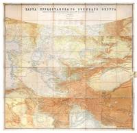
1881rif. 149774St Petersburg: Cartographic Institute of the Military-Topographic Department of the General Staff 1881. The cartographic climax of the "great game" Second edition significantly improved from the first edition 1877 to incorporate the latest military intelligence from field surveys. This magisterial work of "great game" cartography was presented at Russia's Tashkent military headquarters to the daring French explorer Stanislas Benoist-Méchin during his epic 1881-3 overland journey from Beijing to Europe. We have traced no other copies. A presentation inscription on the verso of the map reads in French "To Mr Baron Benoist-Méchin from Generals Kouropatkine and Levaschew October 1882 Tashkent." Benoist-Méchin 1854-1923 began travelling the world as a young man and then served as the French cultural attaché in Tokyo 1880-1. In 1881 he decided to return to Europe via the daring route through Central Asia. Leaving Beijing on 15 September with his regular travelling companion Comte Humbert Adrien de Mailly-Chalon 1853-1921 he journeyed through Manchuria and across Russian Siberia. In 1882 having reached Kashgar they received permission to cross Russian Turkestan spending six weeks in Tashkent as the honoured guests of General Mikhail Tchernayev the architect of Russian's expansion across Central Asia General Aleksey Nikolayevich Kuropatkin 1848-1925 and the aforementioned General Levaschov likely the artillery officer Vladimir Levaschov 1834-1898. After reaching Samarkand they travelled in extreme cold through Bukhara and via Khiva to Tehran reaching Moscow in October 1883 where they were accorded a hero's welcome. Their descriptions of this feat of exploration were published in 1885 in the Bulletin de la Société de géographie. This map was made for the use of the Russian military high command in St Petersburg and in the Turkestan Military District which had been established in the 1860s amid the occupation of Tashkent and Bokhara and dates from a period following the Second Anglo-Afghan War and the Battle of Geok Tepe when tensions were at their height. It encompasses almost the entire playing surface of the "great game" extending east-west from Xinjiang and Tibet to the Caspian Sea and Afghanistan and north-south from Siberia to northern India. Unparalleled in terms of accuracy and detail it names every city town and village and the legend has entries for such features as fortifications railways mail and caravan roads and mines. Spot heights are given in feet and deserts are marked with a light red pattern. It is much improved on the first edition which had only 48 panels and did not extend as far south. Chromolithograph map 195 x 200 cm dissected onto 64 sections and mounted on linen as issued laid-down printed slip stating "corrected up to 1881" small folding tab at right edge. Folding away to 28.5 x 28 cm. Housed in green quarter morocco solander box with chemise by the Chelsea Bindery. Map surface generally clean and brighta few stains toning and soiling at edges small repair at top-left edge verso foxed and with couple of areas of linen reinforcement: very good. unknown
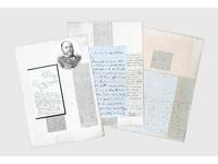
1837rif. 156409Kabul and elsewhere: 1837-41 & 1859. Correspondence chess A carefully assembled collection of material connected to players in the "great game" including Colonel Stoddart and Captain Arthur Conolly both famously beheaded at Bukhara Major Henry Rawlinson the political agent at Kandahar and Captain Sir Alexander "Bukhara" Burns. The material mounted on album leaves with accompanying newspaper clippings and other ephemera is tied together by Connolly and Stoddart's dramatic death. Sent on a mission to secure an agreement of friendship between Britain and the Emir of Bukhara in 1838 Stoddart was arrested by the emir on charges of spying and imprisoned. Conolly the intelligence agent credited with coining the term "great game" in an 1840 letter to Rawlinson arrived in Bukhara in late 1841 to negotiate his compatriot's release. Both men were killed in June 1842 and became household names back home. In the first two letters Burns writing about a year before he was killed by a mob in Kabul shares his views with Rawlinson on the latest moves in the "great game". He writes of Stoddart's short-lived release from prison and of the importance of Conolly's current intelligence-gathering in Central Asia. Shah Shuja "is surrounded by a parcel of harpies" and Burns advises caution about the use of British troops to prop up the Shah's rule: "Nothing contributes so much to lower the King's power as the employment of our troops against Afghans & I would avoid it if possible." As for Lord Auckland the governor-general "does not have great faith in the sincerity of Russia in abandoning her Khiva designs but it gives us time." The third letter from Conolly to Rawlinson discusses local news and offers a lighter-hearted window onto the life of a political agent far from home. He has swapped the diplomatic chessboard for the card table: "We miss you very much - especially at whist" the previous night's rubber being "stale and flat but not unprofitable for I won 9 rupees." This letter is mounted with a page of Stoddart's notes on taking navigational bearings which Stoddart gave to Rawlinson before departing for Central Asia in 1837. The final piece touches on the wider appeal of the Stoddart-Conolly story. Writing to the Cornish baronet Sir Hugh Molesworth almost two decades later Dr Joseph Wolff mentions his second expedition to Bokhara mounted to ascertain the fate of the two men and how the profits from the two editions of his best-selling Narrative of a mission to Bokhara 1845 were sufficient to finance a parsonage and schoolhouse in his living. a Sir Alexander Burns to Major Henry Rawlinson 21 December 1840 Kabul. ALS bifolium written across all sides. b Sir Alexander Burns to Major Henry Rawlinson 20 January 1841 Kabul. ALS bifolium written across all sides. c Captain Arthur Conolly to Major Henry Rawlinson 1840 Kabul. ALS bifolium and single sheet written across 5 sides addressed on final side remains of wax seal. d Colonel Stoddart's autograph notes on taking navigational bearings single sheet written one side. Endorsed on verso by Rawlinson "Given to me by Col. Stoddart on his departure for Bokhara in 1837. H. Rawlinson"; later note to the same effect but in a different hand below. e Revd Dr Joseph Wolff to Revd Sir Hugh H. Molesworth 31 August 1859 Taunton Somerset. ALS bifolium written across 3 sides. 4 autograph letters and single sheet of notes totalling 17 sides of manuscript tipped to or mounted on stubs to card album leaves 370 x 265 mm with laid-down material 11 newspaper clippings 2 printed illustrations sheet of manuscript later brief captions in manuscript. Letters and sheet of notes generally well preserved staining and creasing as expected stubs occasionally just touching text but no loss to sense: a very good collection. unknown
1954rif. 145721London: The Trustees of the British Museum 1954. First Edition. Paperback. Very Good. London The Trustees of the British Museum 1954. Octavo xiii-xviii 165-255 pages. Wrappers a little creased sunned and rubbed; price inked out at the foot of the front cover; an excellent copy. The Trustees of the British Museum paperback
rif. DADAX1491421355New unknown
rif. DADAX1638611580New unknown
rif. SONG041551388XUsed: Good unknown
rif. SONG0847868575Used: Good unknown
rif. SONG1338755420Used: Good unknown
rif. DADAX1647225280New unknown
rif. DADAX1942952538New unknown
rif. SONG1803245158Used: Good unknown
rif. DADAX1801816026New unknown
rif. DADAX1801077339New unknown
rif. DADAX163861069XNew unknown
rif. DADAX1638611181New unknown
rif. DADAX1638610703New unknown
rif. DADAX1787410951New unknown
rif. DADAX000835457XNew unknown
rif. DADAX1476696810New unknown
rif. DADAX1637995997New unknown
rif. SKU0625052W. H. Freeman 2015-12-11. paperback. New. 7x0x9. New Textbook Ships with Tracking W. H. Freeman paperback
rif. SONG0394436679Used: Good unknown
rif. SONG0593519256Used: Good unknown