3989 resultados
Folio. 4 volumes (1 text volume, 2 plates volumes and the supplement volume with plates and interleaved text). (406); (96) ff. plus plates. With lithographed title-pages in plates and supplement volumes; in total 552 plates (the plates volumes with in total 432 lithographed plates (425 hand-coloured, 7 black and white); supplement volume with 120 hand-coloured lithographed plates. Contemporary red half sheepskin. Rare complete set with the supplement (often lacking) of a sumptuous botanical work with 552 striking lithographic plates by Aimée Henry. Among the plants and trees depicted are the date palm, the Commiphora gileadensis, and the Acacia Arabica. The work was begun by M. F. Weyhe, J. W. Wolter and P. W. Funke, and finished by the important German botanist and pharmacologist Theodor Friedrich Ludwig Nees von Esenbeck (1787-1837), best remembered for his systematic research on the medical properties of plants, which helped to establish pharmacology as a serious academic discipline. The plates appeared in instalments between 1822 and 1828, followed by several instalments of text, and finally a supplement volume in 1833. Some confusion exists as to the general title of the work, since the volumes of plates are titled "Plantae medicinales", whereas the text volume was published as "Plantae officinales". - Bookplate and library stamps in each volume. Some browning and foxing as usual; bindings worn. A good set, rare in its present complete form. GFB, p. 69. Johnston 945. Nissen, BBI 1442. Plesch p. 347. Pritzel 6662. Stafleu/C. 17391. Cf. Graesse IV, 655.
Folio (ca. 280 x 365 mm). 3 vols. XVII, (3), 482 pp. (2), 483-1041, (2) pp. With 2 folding maps and illlustrations in the text. Vol. III (atlas): half-title and 100 engraved plates, 84 of which in original hand colour, with descriptions. Original printed wrappers; vol. III in contemporary half cloth. Stored in decorative full cloth slipcases. First edition. Signed presentation copy, inscribed by the author to the entomologist and carcinologist Eugène Louis Bouvier (1856-1944), who wrote the introduction to this elaborate entomological work: "A Monsieur le Professeur Bouvier, à qui je dois toute ma reconnaissance pour avoir mené à bonne fin cet important ouvrage faisant le plus grand honneur à sa haut compétence et à son grand dévouement à la sciene [...]". - Between the years of 1904 and 1905 Maurice de Rothschild (1881-1957) led and financed a collecting expedition in East Africa, travelling from Djibouti, across Eritrea to Ethiopia and Kenya. The collected specimens were presented to the Paris Natural History Museum. A large number of entomologists, including Charles Rothschild (1877-1923), worked on the specimens, their descriptions - some in Latin - being published in the first two volumes. A total of 68 specimens were named 'rothschildi', although not all of them are today known by this name. The third volume, containing exquisite colour illustrations of the insects, occupied a similarly large number of artists. - Uncut. Bindings somewhat worn; interior crisp and clean. A very well preserved copy of this elaborate work. Rare: a single copy in auction records. BM (NH) VIII, 1096. Not in Nissen or Pankhurst.
Folio (210 x 345 mm). 22 issues. Together (58), 388 pp. With 2 photographs, 1 plate of graphs showing incidents in Egypt, June-July 1946, 1 folding plan of Persian Azerbaijan, 1 folding plan of Greece and Western Turkey, and 1 folding map of Middle East Intelligence. Original printed stapled wrappers. An intriguing specimen of British post-war intelligence documentation rarely seen in the trade, focussing on but not limited to the Middle East. Based on the Middle Eastern Intelligence services' zones of major responsibility and their spheres of interest (see the map in vol. 100), their reviews cover a vast range of topics. They not only outline the Anglo-Egyptian treaty negotiations and the political situation in Libya, Palestine, and Syria, but also discuss the Arab League (photograph of a meeting of the League in vol. 90), terrorist attacks carried out by Jewish illegal forces in Palestine, the struggle with illegal immigration (a photograph showing a boat of immigrants in vol. 74), and political Zionism. However, the reviews also cover the political and economic situation in Germany, the problem of former Nazi sympathisers regaining positions of power and security (sketched out in the case of "Dr. Drecksacker"), and include an eye-witness report by an SS man employed at the Auschwitz concentration camp, translated into English. British views on Russia make up another significant part, including the reprint of an article by the American journalist Brooks Atkinson, published in the U.S. magazine "Life", accusing Soviet leaders of "group paranoia", as well as analyses of Russian broadcasts with respect to Middle Eastern countries. Moreover, the reviews outline British relations with Greece and the Balkans, France, Yugoslavia, Bulgaria, Italy, Turkey and Kurdistan, Romania, and India, while also discussing the organisation and functions of the U.N. - Despite the imprint indicating a print run of 400 copies, none can be traced on WorldCat. A 12-volume set was sold at Christie's in 2018. - Wrappers have stamps of the "Assistant Director of Medical Service 3rd Divisions". Traces of rust near the staples. The first two pages of vol. 100 loose; a small tear on pp. 9f. of vol. 90, as well as a small flaw to the title-page of vol. 98, neither touching the text. - A rare window into the issues that concerned the British military intelligence following WWII.
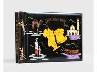
1955ref. 188201On board HMS Loch Alvie: South Asia and Arabian Gulf 1955-56. Striking visual record of the Gulf at the dawn of the oil boom An attractive photograph album compiled by a Royal Navy rating during service in the Gulf in 1955-56 notable for its early views of Abu Dhabi and other sites in the present-day UAE on the eve of the oil transformation. Drawn to the stark coastline and improvised shore installations he recorded places that within a decade would be reshaped by petroleum infrastructure and urban expansion. Several images relate to Abu Dhabi. A view of Das Island dated 11 April 1956 shows a bare shoreline with oil drums and rudimentary structures in the first phase of development linked to the Umm Shaif field. At Khawr al Bazm 19 April 1956 he photographed the coast from the ship and the firing of a 21-gun salute for the Queen's birthday juxtaposing imperial ceremony with an undeveloped littoral. Four deckle-edged photographs depict Dalma Island - then a remote outpost - including a grave the remains of a wrecked dhow and the stretch of coast where the vessel was driven ashore in bad weather. Today Dalma is recognised as a major archaeological site within Abu Dhabi emirate. Dubai appears in a 22 April 1956 view of water taxis and the souq along Dubai Creek still a modest mercantile settlement. The following day Lord and Lady Mountbatten paused there during their return from Asia and Australasia an event marked by guards of honour and captured in the album. A coastal view of Dibba on the Musandam Peninsula - now divided between Oman and the UAE - records the rugged shoreline before modern development. Although centred on the Gulf the album also includes related regional material - Bahrain including Juffair naval base Qatar's early oil installations at Umm Said and Halul Island and shipboard scenes - placing the UAE images within the wider strategic network of Britain's post-war naval presence east of Suez. The volume concludes with an official photograph of HMS Loch Alvie and a track chart of her cruise under Captain C. J. Matthews sailing from Chatham in July 1955 and returning in July 1956. Landscape folio 270 × 390 mm. 88 mounted silver gelatine photographs the majority personal rather than purchase and 24 of which relate to the Gulf various formats mostly 105 x 80 mm the great majority captioned in white ink leaves additionally decorated with small sketches and various ephemera. Asian black lacquer album silk ties at the spine typical of those available at the Liberty Stores Aden lettered "Souvenir of Aden" on the front cover with a hand-painted map of the Arabian Peninsula and Red Sea surrounded by images of a mosque camel dhow and local inhabitants HMS Loch Alvie cap tally pasted to spine edges gilt decorative gold and silver leaf spackled endpapers; black card mounting leaves. Corners a little bumped and worn a couple of cracks to the lacquer to the back cover; some tissue guards a little creased contents otherwise clean sound and complete; very good. unknown
Large 12mo. 24 vols. With engraved portraits of Barros, Couto, Henry the Navigator, and Afonso de Albuquerque and 3 (instead of 5) folding maps. Uniformly bound in contemporary half calf over marbled boards, spines with giltstamped titles and volume numbers. Edges lightly sprinkled red. A fundamental travel work: the best and most complete edition of what is considered the most comprehensive publication on Portuguese exploration and colonial history by João de Barros (decades I-IV) and Diego de Couto; the first edition to include decades X and XI. Books 2 and 3 of the "Decada Segunda" offer a detailed narrative of Afonso de Albuquerque's expedition to the Arabian Gulf and his conquest of Ormuz in 1507; the island remained under Portuguese occupation from 1515 to 1622. As vassals of the Portuguese state, the Kingdom of Ormuz jointly participated in the 1521 invasion of Bahrain that ended Jabrid rule of the Arabian archipelago. - This is "the best edition of this famous work on Portuguese colonial history. The first edition appeared at Lisbon, Madrid and Paris from 1552 to 1645. It consists of 12 "Decadas" (decades), comprising the history of the years 1420-1600. Only Decadas I, II, III and a part of IV are by J. de Barros, the rest is by D. de Couto, who begins his part also with Decada IV, so that there are two Decadas IV" (Laures). De Barros (1496-1570), head agent for the Portuguese overseas trade authority "Casa da Índia", managed to persuade King João III to commission from him a history of the Portuguese in India (including Asia and southeast Africa). The result earned him renown as one of the first great Portuguese historians, and the the title of a "Portuguese Livy". The 'Decades' contain "the early history of the Portuguese in India and Asia and reveal careful study of Eastern historians and geographers, as well as of the records of his own country. They are distinguished by clearness of exposition and orderly arrangement. They are also lively accounts" (Enc. Britannica). Cordier, BJ, 34 and BS, 2309. Innocencio III, 322. Laures 642. Streit IV, 667 (with extensive list of contents) & VI, 630. This edition not in Borba de Moraes. For the maps cf. Gole, India, 8.
2 volumes. 8vo (160 x 216 mm / 160 x 205 mm). Arabic manuscript on polished paper. First volume: 340 ff.; title-page with gilt borders. Second volume: 178 ff. Script in black naskh with occasional words, phrases, and punctuation in red. 19th century leather and morocco with fore-edge flaps, stamped in blind. An important Arabic bestiary and the most famous work of al-Damiri (1341-1405), little known in the West. In the "Hayat al-Hayawan", al-Damiri alphabetically lists over nine hundred animals mentioned in the Qur'an or known in Muslim literature; his extensive commentary explains the use of such animals in medicine, tradition, and ancient poetry: whether they can lawfully be eaten, and their role in folklore and superstition. - Al-Damiri was a Muslim writer from Mamluk-era Egypt, and his other works are largely on canon law. His natural history, however, is considered his most influential and popular writing. - The first volume is not dated or signed, but was written in the Ottoman provinces in the 18th century; the second volume was completed by the scribe Umar ibn Abd al-Da'im ibn Umar al-Dandi on the 15th of Muharram 1024 H (14 February 1615 CE). Covers a little worn, spines professionally rebacked, some light paper repairs and soiling. A scarce and appealing piece of mediaeval zoology; complete in two volumes dating from the 17th and 18th century. Cf. GAL II, 137/8.
159 x 108 cm (conjoined sheets), in hand colour. Scale ca. 1:12,000,000. A magnificent coloured wall map, enclosed within historiated borders showing topographical vignettes, printed on four conjoined sheets with additional running title above and engraved text providing geographical and political information to the sides, all on additional sheets. While it is a map of Africa, it also shows the Arabian Peninsula in its entirety. - The cartographer Nicolas de Fer (1646-1720), son of a Parisian engraver specialising in the colouring and selling of maps, maintained a good relationship with the Academy of Sciences and was Geographer Royal to the Dauphin and the King of Spain. Nevertheless, his productions were not aimed at a university-educated audience, and his work is distinguished by easy accessibility and popularisation of geographical information rather than by scholarly precision. The present rendering of Arabia, apparently based in part on the work of Delisle, shows this posthumous publication (by de Fer's son-in-law Danet) to be a later release of a much early conception of the Middle East, outdated even in the 1740s. In particular, it omits the Sinai Peninsula included in several of de Fer's earlier efforts. "Like Delisle, De Fer had considerable prestige and influence in France and all over Europe" (Historical Atlas of the Gulf, p. 278). Among the toponyms along the coast of the Arabian Gulf are Abadan, Sur, Ahsa, Janama, Bahr, El Catif, Bischa, Borou, Godo, Vodana, Calba, Dadana, and Pinder. - Professionally repaired; some wrinkling, but preserving its impressive wall appearance. Cf. OCLC 71549733. Historical Atlas of the Persian Gulf (16th to 18th c.) 70 (1717 map). Khaled Al Ankary, The Arabian Peninsula in Old European Maps, 112 & 140.
Folio (368 x 272 mm). 30 lithogr. plates, including one title page. Bound in contemporary oblong red half morocco, spine bearing giltstamped title "Chevaux et Voitures". Three series of Gericault's horse studies, each complete as published and in excellent impressions on strong wove paper (not watermarked), bound together with a hitherto unrecorded depiction of a sheikh on an Arabian horse. The first series, published as "Etudes de Chevaux lithographiés" in 1822, shows various horse races, including the Arabian horse as well as Egyptian, English, and French horses. "Cet ouvrage sera composé de trois livraisons, dont chacune contiendra quatre planches" (Beaux-arts de Paris). Second of at least four states throughout, stating the names of the artist and printer. The second series, published without a title in 1823, shows the various purposes for which horses are used (racehorses, military horses, cart horses and postillon horses, among others) and is complete as well with eight prints. The third series, likewise issued without a title in 1823, comprises seven prints depicting cavalry, trotters, a horse leaping over an obstacle, and a jockey on his horse, also including two oriental-themed plates: a lion devouring a horse and a fist-shaking "Giaour" (not from Géricault's Byron series). Three plates from this set are identified by Delteils as contemporary copies by Louis Courtin. The lithographed frontispiece of the first series was bound at the beginning of the present volume to serve as a title. The final leaves in this collection are the dead horse in the snow (an image inspired by Napoleon's Russian campaign) from Géricault's 1823 series "Quatre sujects divers" and a fine plate of a pistol-wielding Sheikh mounted on his Arabian steed, with an oriental desert settlement in the background (not recorded by Delteil). "Gericault est, sans conteste, un des plus grands peintres hippiques de son siècle [...] Les bonnes épreuves sont recherchées et et assez rares" (Mennessier de la Lance I, 545). - Of the utmost rarity: while the British Museum holds the complete suite of the first series, we were unable to trace any complete copies of the other suites contained in this sammelband. While numerous separate Gericault lithographs sold at recent auctions, realising up to £3000 each, not a single complete suite is listed in auction records of the last decades. - All prints are of exceptional quality, with rich contrast on superior paper, occasionally showing various degrees of foxing in the margins; a minute tear to the lower edge of the title leaf. Attractively bound in red half morocco with sparsely gilt spine. Altogether a beautiful copy in excellent, crisp condition. Delteil 46-57; 58-65; 66-72; 77.
8vo. (2), CLXVI ff. With several botanical woodcut initials. Contemporary dark goatskin, blind-tooled in a panel design. First edition of this important capsule edition of Ibn Sina's comprehensive Canon of Medicine (Kitab al-Qanun fi al-tibb). Designed with the Western medical student and practicioner in mind, Michael de Capella's abridgement of the greatest and most influential work in mediaeval and early modern medical history is here pared down to a nutshell manual of 166 leaves. "The preface … refers to the importance in medicine of aphoristic works that can readily be committed to memory and to the example of Hippocratic writings. The task of abbreviation was undertaken with such enthusiasm that Avicenna's chapter on the elements (Canon 1:1:2) [...] was compressed from about 550 words in the full Gerard of Cremona version into 53 in the 'Flores'. This compendium was twice reissued, in 1514 and again in 1528" (Siraisi). - Provenance: 1) Title-page shows handwritten ownership of the Augustinian monastery of Zaragoza, Spain, dated 1743. 2) 20th century bookplate of Karl and Thilde Wagner to front pastedown. - Binding somewhat worn, spine-ends and extremeties chipped. Some browning throughout, inkstains on title-page and a couple of minor stains in text. A good copy. Adams A 2319. Durling 411. USTC 143378. N. G. Siraisi, "The Changing Fortunes of a Traditional Text", in The Medical Renaissance of the Sixteenth Century (1985), p. 21. Cf. BM-STC French 234 (1514 ed. only). Cf. Wellcome I, 577 (1528 ed. only).
1065 x 578 mm. Cloth-backed engraved view on 2 sheets joined, letterpress text pasted below (4 columns in Italian: "Descrizione della Città di Alessandria d'Egitto") with publisher's imprint. Matted. Unrecorded in the standard bibliographies and without counterpart in western libraries: a unique, large-scale view of Alexandria as seen from the north. Formerly the most powerful city of the ancient world after Rome, Alexandria came under Ottoman rule in 1517 and subsequently lost much of its importance to the new port of Rashid (Rosette), 40 miles east, though it would regain some of its former prominence with the construction of the Mahmoudiyah Canal in 1807. In Longhi's engraving, the Ottoman influence may be discerned in the people's clothing as well as in the city's architecture. Within the city are several mosques; the ancient obelisks are shown crowned with crescents. On the river Nile, which flows through the city and underneath the walls, the view depicts numerous trade boats and sailors. Outside the walls lies Pompey's Pillar. The Italian letterpress text pasted under the engraving provides mostly historical and geographical information. - Longhi's panorama seems to draw various aspects from previous works to create its own original representation of the Egyptian city. The perspective is similar to that used in Pierre Belon's 1553 "Observations" and in Braun and Hogenberg's 1575 "Alexandria, Vetustissimum Aegypti Emporium, Amplissima Civitas", published in their famous "Civitates orbis terrarum", but also to that in Mallet's smaller, almost certainly later (1683) view of Alexandria. Apart from the Braun/Hogenberg map, however, the principal model for Longhi's view was likely his own view of "Gran Cairo", apparently published simultaneously: the bird's-eye view and general composition correspond to this similarly rare engraving, which was probably based on a 1549 woodcut panorama created by Matteo Pagano in Venice. - According to scholars, Gioseffo (Giuseppe) Longhi (1620-91) issued a series of views of Italian and foreign cities between 1654 and 1674. A publisher, bookseller and archiepiscopal printer, he was active in Bologna from 1650 to the time of his death. Not only did he publish maps, but he was also a prolific literary editor, notably publishing all the dramatic works of the Italian playwright Giacinto Cicognini. - An excellent specimen. Cf. Tooley, Mapmakers III, 150 (for Giuseppe Longhi).
945 x 620 mm. Engraved view on 2 sheets joined, letterpress text pasted below (4 columns in Italian, 4 columns in Latin: "Descrittione del gran Cairo [...] Cairi quae olim Babylon") with publisher's imprints. Watermark Panzano. Unrecorded in the standard bibliographies and without counterpart in western libraries, this unique, large-scale view of Cairo reflects the economic and cultural effervescence of the second-largest city in the Empire: under Ottoman rule since 1517 and having expanded south and west from its nucleus around the Citadel, Cairo in the latter half of the 17th century was second only to Constantinople. The Ottoman influence may be discerned in the people's clothing in the foreground as well as in the city's architecture. On the river Nile, the map depicts numerous trade boats and sailors. To the left are soldiers battling as part of a tournament; on the right are the Sphinx (wearing a necklace!) and the famous pyramids of Giza: those of Khufu, Khafre, and Menkaure, as well as the smaller pyramids. The centre of the city shows numerous mosques and gardens. The letterpress text pasted under the engraving provides mostly historical and geographical information (in Italian and Latin). - Longhi's panorama seems to draw various aspects from previous works to create its own original representation of the Egyptian city. Indeed, it bears some resemblance to Braun and Hogenberg's 1572 "Cairos, quae olim Babylon, Aegypti maxima urbs", published in their famous "Civitates orbis terrarum". There are also similarities with Donato Bertelli's "La gran città del Cairo" (Venice 1575), as well as with the map of "Le Grand Caire" produced by the French soldier and traveller Henri de Beauveau (published in his "Relation journaliere du voyage du Levant", Nancy 1615). Ultimately, these plans probably all derive from a 1549 woodcut panorama credited to Matteo Pagano (or a Venetian engraving derived from it), as they all depict the city from the same viewpoint and on a similar scale. Longhi's map even takes up some of the ornaments of the Braun/Hogenberg map, such as the two people riding on a horse and a donkey in the foreground, though the antiquities as well as the numerous irrigation wheels are here shown in much greater detail. - According to scholars, Gioseffo (Giuseppe) Longhi (1620-91) issued a series of views of Italian and foreign cities between 1654 and 1674. A publisher, bookseller and archiepiscopal printer, he was active in Bologna from 1650 to the time of his death. Not only did he publish maps, but he was also a prolific literary editor, notably publishing all the dramatic works of the Italian playwright Giacinto Cicognini. - Some small marginal tears repaired; slight marginal fraying to upper left. Cf. Tooley, Mapmakers III, 150 (for Giuseppe Longhi); Schulz, Venice 70 (for Arrigoni/Bertarelli).
Colour lithograph map, 765 x 495 mm, trimmed to neat line. A rare separately issued official map, with text in Ottoman Turkish throughout, depicting the route of the Hejaz Railway. Following a route proposed by the eminent Turkish engineer Mukhtar Bey and surveyed by the cavalry officers Umar Zaki and Hasan Mu'ayyin, the epic project, funded by subscriptions from the global Islamic faithful, completed a rail link from Damascus to Medina by 1908. Intended to continue to Mecca but never completed, it nevertheless briefly allowed many thousands of pilgrims to make the Hajj in relative comfort. - Old folds and creases, some short closed tears, tiny chips to neat line, some light staining. Some remnants of tape and old private collector's stamps to verso. Still in good condition but for partial loss of lower left corner, subsequently collaged with a contemporary Ottoman colour lithographed map of the Arabian Peninsula.
4to (160 x 244 mm). Arabic manuscript on polished oriental paper. (252) pp., 21 lines, per extensum. Black ink with red underlinings and emphases. With numerous red ink diagrams in the text and margins. Contemporary blindstamped full calf, restored and spine rebacked. A fine mid-17th century Arabic manuscript of Euclid's famous "Elements of Geometry", the "oldest mathematical textbook in the world still in common use today" (PMM). The translation is by the great Persian polymath Nasir ad-Din at-Tusi (1201-74), after whom the lunar crater "Nasireddin" is named. Written in Central Asia, this manuscript comprises fifteen books rather than the usual thirteen. Some of the marginal diagrams may have been added later. - Paper browned and somewhat mottled throughout, less so near the end of the volume. The restored binding uses the stamped original cover material. Cf. GAL I, 510, 23.
Tall 8vo (136 x 258 mm). Arabic manuscript on unsophisticated oriental paper. 206 leaves. 20 lines, black and occasional red ink with underlinings in red. Restored red morocco oriental binding with blind-tooled medaillons to both covers, using oder material from a shorter binding. The fourth and final part of Ibn Sina's famous "Kitab Al-Shifa'" ("The Book of Healing"), a great scientific and philosophical encyclopedia that covers logic, natural sciences, mathematics including astronomy, and, as here, metaphysics and religion. - Browned throughout with occasional waterstaining. Early waqf stamp near the colophon. In all a good manuscript, copied in Safavid Persia by Shafi' Muhammad bin Muhammad al-Qayni. GAL I, 454, 18.
Small folio (ca. 210 x 314 mm). (10), 308, (12) pp. With engraved title-page and 5 full-page engraved illustrations in the text, as well as several woodcut initials and woodcut printer's device. Contemporary full vellum. All edges red. Second, improved Latin edition of this famous account of a pilgrimage to the Holy Land by the Polish Prince Mikolaj Krzysztof Radziwill (1549-1616), frequently translated and reprinted. First published in 1601; the present edition is corrected and expanded. - During his two-year journey from 1582 to 1584 Radziwill visited not only Palestine, but also Syria, Egypt, Crete, Cyprus, Italy and Greece. "Radziwill, in his account of the pilgrimage to the Holy Land and Egypt, described the ethnic diversity of the inhabitants of these lands. Critics underline the fact that his descriptions were ethnographic in character and quite objective. His 'Peregrynacja' was published in Latin and in Polish and apparently was quite widely read" (S. Grodz, Islam in Polish-Lithuanian/Ottoman Encounters, in: The Character of Christian-Muslim Encounter, Leiden 2015, p. 234). - The emblematic illustrations show sailboats in a fierce storm, such as Radziwill himself encountered, as well as appropriate Biblical quotations in banners decorated with maritime elements, but also a plan of the Church of the Holy Sepulchre in Jerusalem (a separate appendix describes the prayers and songs there to be sung). - Binding somewhat brownstained and a little warped; upper hinge starting. Paper evenly browned throughout, occasional brownstains. Provenance: from the library of Duke Franciszek Maksymilian Ossolinski (1676-1756), Polish politician in the service of the exiled Stanislaus I. Leszczynski and an important collector, with his autograph ownership inscription "Ex Libris F. M. Ducis de Tencryn-Ossolinski", dated Lunéville, 12 Sept. 1741, to front pastedown, and a three-line handwritten French quotation from St. Augustine to lower pastedown. In all a good copy of a widely received work; this edition rarely seen at auction. Weber II, 204. Röhricht p. 208, no. 787. Estreicher XXVI, 90. Brunet IV, 1087. Graesse VI, 17. Baumgarten, Hall. Bibl. VI, 65f. Ebert II, 18596. Tobler 83. Cf. Aboussouan 769.
4to (19.5 x 15.5 cm). (4), "139" [= 135], (5) pp. With a woodcut ship on the title-page (with a griffin on the sail) and about 60 woodcut illustrations in the text (mostly about 55 x 80 mm) plus about 10 repeats, each with a thick-thin border. Set in textura types with incidental roman and italic. Gold-tooled, red goatskin morocco by Robert Riviere in London (ca. 1875/80), with 5 (false?) bands on the spine, each board with a double frame of double and triple fillets and 2 different sets of 4 corner pieces, author and title in gold in 2nd and 3rd of 6 spine compartments, the others with gold-tooled decorations and the date and place of publication at the foot, gold-tooled turn-ins, gold fillets on board edges, straight-combed endpapers, gilt edges, stamped on the back of the free marbled endleaf in sans-serif capitals: "Bound by Riviere". A rare 17th-century English edition, with about 60 different woodcut illustrations, of a classic and partly fictional 14th-century account of travels presented as voyages of Sir John Mandeville through Turkey, Egypt, Ethiopia, Syria, Persia, Arabia, India and the East Indies. According to the story he set off on his travels in 1322 from Saint Albans in England, returned in 1343, wrote the present account in 1364 and died in 1371. It was originally written in French and is thought to have been compiled from various sources by Jehan d'Outremeuse (1338-1400) of Liege. A 1371 manuscript survives and it first appeared in print under the title Itinerarius in Dutch (ca. 1477), French (1480), German (1480) and other languages, and in English in Richard Pynson's edition of ca. 1497/98. It includes many well-known stories and illustrations of monstrous people and animals in exotic lands: a man with only one enormous foot that he can use as a parasol, a dog-headed man, a man with his face in his chest, a girl who turns into a dragon, griffins, nine-metre giants, ants that gather gold, diamonds that mate and give birth to baby diamonds and much more that spoke to the imagination (though the ox-headed man is presented as an idol that was worshipped, rather than a fantastic beast). The book also includes genuine descriptions of the regions covered and gave many Europeans their first notions of the Near East, Middle East, India and East Indies. It shows carrier pigeons, an elephant and other recognizable or plausible scenes. It also incorporates and illustrates some biblical stories. The part on Arabia includes an account of the birth of Mohammed. Most of the present woodcuts are loosely and indirectly based on those in the 1481 Augsburg edition, partly in mirror image. The book went through dozens of editions in English and other languages. It reached more or less the present form with the 1650 London edition, which may have used the same woodblocks (we have not had an opportunity to compare them). The imprint of the present edition names four London publishers, and one of them (Conyers) also advertises his edition of William Lithgow's Nineteen years travels (1692) at the foot of the last page. The book was registered for these four publishers in the term catalogue for Trinity 1696, issued in June. The printing was probably shared between two different anonymous printers: exactly half way through the book, between quires I and K, the running heads, the textura type used for the main text and the roman drop capitals opening the chapters change. The 1684 edition by four London publishers (none named in the present edition) not only uses the same woodblocks but is also typographically almost identical to the first half of the present edition and no doubt came from the same printer. The drop capitals differ, but those in the present edition have not been recorded before 1688. Samuel Roycroft and James Orme both used them, and Roycroft used at least several of the other types in the first half. The book is printed on coarse laid paper with no watermark. Halliwell, in his 1869 edition of Mandeville, noted the present edition for its woodcuts and reproduced at least many of them from the Grenville copy now at the British Library. Only 5 other copies are known, all in U.S. libraries. Robert Riviere (1808-82) established his famous bindery in Bath and moved it to London in 1840, gaining a reputation as one of England's best binders for the quality of his materials and workmanship. He signed his bindings "Bound by Riviere" from 1860 to 1880 (thereafter Riviere & son). - With an early owner's inscription faded on the title-page and 2 armorial bookplates on the paste-down: Sir Edward Sullivan (1822-85), Lord Chancellor of Ireland, and Allan Heywood Bright (1862-1941) in Liverpool, a member of Parliament, along with a loosely inserted signed autograph letter (ca. 1900) from Bright's brother Hugh Bright (1867-1935) in Leeds, giving him the book and noting that he bought it at Young's "some years ago". With 8 leaves with their margins extended at the fore-edge and foot ( N2-O4, Q1, probably sophisticated from another copy of the same edition), sometimes shaving a catchword or quire signature, the title-page and last page somewhat worn and dirty, but further in good condition, with a few minor marginal chips and tears restored or repaired and 3 leaves with minor water stains in one corner. The spine is slightly faded but the binding is still very good. A rare edition of Mandeville's voyages, illustrated with about 60 woodblocks cut ca. 1650. Arber, Term catalogues II, p. 593, item 8; ESTC R217088 (5 copies); J. O. Halliwell (ed.), Voiage and travaile of Sir John Maundevile (1866), p. xvi (item 2, from the Grenville library); Wing M417 (same 5 copies); for the story in general: Cambridge History of English Literature (1976), pp. 78-87.
Folio. (16), 311, (60) ff. Title-page and sub-title to index with ornamental woodcut border. Woodcut initials, head and tail pieces. Calf, gold-tooled ribbed spine with title-label. Sprinkled edges. First edition of the "Natural history" edited by Johannes Caesarius (1468-1550), a humanist and close friend of Erasmus. The original text was by Gaius Plinius Secundus (AD 23 - August 25, AD 79), better known as Pliny the Elder. He was a Roman author, naturalist, and natural philosopher, as well as naval and army commander of the early Roman Empire, and personal friend of the emperor Vespasian. The text in the present edition is decorated with woodcut borders and many woodcut initials. - The "Naturalis Historia" is one of the largest single works to have survived from the Roman empire to the modern day and purports to cover the entire field of ancient knowledge, based on the best authorities available to Pliny. He claims to be the only Roman ever to have undertaken such a work. It comprised 37 books in 10 volumes and covered over 20,000 facts on topics including the fields of botany, zoology, astronomy , geology and mineralogy as well as the exploitation of those resources. It remains a standard work for the Roman period and the advances in technology and understanding of natural phenomena at the time. Some technical advances he discusses are the only sources for those inventions, such as hushing in mining technology or the use of water mills for crushing or grinding corn. Much of what he wrote about has been confirmed by archaeology. ''We know from Pliny that there were important pearl fisheries in the Gulf [...] Pliny identifies Tylos (Bahrain) as a place famous for its pearls [... He] attests that pearls were the most highly rated valuable in Roman society, and that those from the Gulf were specially praised [...] The pearl related finds at the site of El-Dur indicate the site was integrated into the maritime trade routes linking the Roman Empire, the Persian Empire, India and South Arabia'' (Carter). Book 6 holds a chapter that gives the first detailed account of the regions around the Gulf, including what are now Qatar, the Emirates and Oman. - Not only is it virtually the only work which describes the work of artists of the time, and has it become an important reference work for the history of art, due to the wide range of topics, the referencing system and index it became a model for later encyclopaedias. - With manuscript notes of multiple owners on pastedown (including written ex-libris by Antonii Mauritii Seguin 1713 and Mathon de la cour 1744). Some underling in text, and notes in the margins (partly lost due to trimmed edges). A very good copy with bookplate of De Ponsainpierre on pastedown. VD 16, P 3531. Adams P 1556. BM-STC German 704. Durling 3689 (imperfect copy). Hunt 23. USTC (11 copies).
Three parts in one volume. 4to. 220 x 155 mm. Woodcut device on general and parts titles. Early blindstamped calf, rebacked and refurbished retaining most of original spine. First edition, second issue. Guillaume Postel travelled to Constantinople in 1535 as official interpreter to the embassy of Jean de La Fort to the Turkish sultan, Suleiman the Magnificent. He returned there in 1549, and was also the author of the first Arabic grammar in French. "His work is not so much a descriptive account of his travels as a compendium of information gleaned while traveling and from other sources. The third book, 'La Tierce Partie des Orientales Histoires', furnished an usually complete and accurate picture fo the governing system of the Ottoman Empire" (Blackmer). - Without final blank ff6, 2 single wormholes in lower margin of opening few leaves, small repair at inner lower corner of opening 2 leaves, early ownership inscription on first title. Cf. Adams P2015. Atabey 977. Blackmer 1335.
12mo. (10), 180 pp. With engraved additional pictorial title and small woodcut ornament to printed title; woodcut head- and tail-pieces and decorative initials. Contemporary full vellum. Extremely rare first edition of this history of gemstones, corals and pearls, with plentiful references to the Arabian Gulf ("ou Mer d'Elcatif"), and specifically to Bahrain, Al-Qatif, Muscat, and Ormus, including separate chapters on pearls, their valuation, and the process of pearl-fishing. Carter lists Chappuzeau's work, which draws strongly on Tavernier, under the "key European accounts", quoting his mention of the Gulf as a major source of pearls: "The most significant pearl fishing ground is on the coast of Arabia Felix, between the towns of Julfar and Catif" (p. 94). - Chappuzeau's "text is in two parts, the first, of six chapters, describes gemstones beginning with diamond, then those of color, pearls, coral, amber yellow stones, the metals, ambergris, bezoar, indigo and other 'rich productions' of the East and West Indies, and including salts. The second part describes the places referred to in the first part, from Abyssinia to Visapur [...] Chappuzeau provides information on places in India where diamonds are found, how they are mined, and prices demanded for diamonds and other gemstones. The method of pricing pearls is also given along with a table of values [... This chapter] is famous for its perpetuation of the story that pearls generate from dew drops falling into the gaping shells of the pearl oysters" (Sinkankas). Also includes references to mining in Peru and trade from the West Indies and Americas. - Spine somewhat dust-soiled; interior shows some browning throughout. Provenance: Contemporary ink ownership "F. Baker" (?) to title-page. Latterly removed from the Library of the Birmingham Assay Office, one of the four assay offices in the United Kingdom, with their inconspicuous library stamp to the flyleaf. Vastly rarer than the 1671 English edition: no other copy seen in the trade. Sinkankas 1251. Sabin 12010. Cioranescu (17th c.) 18639. OCLC 78250964. Carter, Sea of Pearls, pp. 94 & 106. Cf. Hoover 217; Roller/Goodman I, 222; Macclesfield 512 (for the 1671 English translation).
(2) Burton, Richard F. Supplemental Nights. (3) Burton, Richard F. [Autograph manuscript book review of an 1881 Panchatantra edition]. 16 volumes (including 6 supplements). 8vo. With an original manuscript leaf written by Burton (with the manuscript heading: "Proof to Sir R.F.B. Hotel des Bains, Aigle, Canton Vaud, Switzerland" and a note "Long Primer Pressig.") and each volume with a different frontispiece in two states (coloured and uncoloured). Contemporary richly gold-blocked green morocco, boards with Arabic script in gold, spine with raised bands, gold-tooled turn-ins, marbled paste-downs. The so-called "manuscript edition" of Richard Burton's celebrated translation of Alf Laylah Wa Laylah, commonly known in English as the Arabian nights. These Arabic tales, cherished in Europe since the early 18th century, are often erotic in content, and in Burton's unexpurgated translation they outraged Victorian England. Burton included numerous footnotes and a scholarly apparatus, offering a vivid picture of Arabian life, which set his translation apart from earlier English renderings. - The present edition (limited to 99 sets, the present being copy no. 49) includes a manuscript leaf from a text by Burton. In the present copy this is a book review by Burton, of a French translation of Johannis de Capua's Latin translation of a Hebrew translation of the Panchatantra, a Sanskrit frame story written several centuries before the Arabian nights. The notes at the head show that it was used as printer's copy. - The title-page of volume one uses the correct main title, The book of the thousand nights and a night, but confusingly mixes it with part of the subtitle of the Supplemental nights: "to the book of the thousand one nights with notes anthropological and explanatory". To add further confusion it says "volume three", though the content is that of volume one. The volume number is clearly a printer's error, apparently corrected early in the press run. - Ross dates the (regular copies of the) present edition ca. 1940. This later date is supported by the fact that this edition is not included in Penzer's thorough bibliography published in 1923. - Some minor browning to the endpapers, those of the first volume partly detached and with a small pieces torn off, the binding has some very minor wear to the hinges, and a few headbands have been carefully repaired. A fine set. Scheherazade's Web: The 1001 Nights & Comparative Literature, J. Ross 10 & 11. Cf. Penzer, pp. 126-132 (other Burton club editions).
Folio (213 x 442 mm). Black Naskhi on paper, decorated with an illuminated sarlowh in red and blue. Mounted on cloth. Rare 18th century copy of the "Ashtiname" (Covenant), a charter granting protection and other privileges to the followers of Jesus, issued to the Christian monks of St Catherine's Monastery, Sinai, supposedly by the Prophet Muhammad and dated Muharram of the year 2 of the Hegira. - A handwritten copy of a famous document from the early history of Islam: it assures the Christian populations of the protection of their property as well as their places of worship, among other privileges. While the authenticity of the text has been called into question by many scholars, the history of its reception over the centuries remains a fascinating subject. The supposed original document, which was given by the Prophet Muhammad to the monks of St Catherine's Monastery in Sinai, was confiscated by Sultan Selim I (ruled 1512-20) during his campaign in Egypt and Syria in 1516/17. Subsequently, numerous copies were drawn up so as to renew the protection offered to Christians. Their authenticity is assured by the certification of a qadi, our document bearing the signature of the qadi of Egypt, a certain Isma'il, affixed by way of a seal in the right margin of the document. - Minor repairs and dampstaining, but well preserved.
Folio (240 x 352 mm). (56), 1203 (instead of 1207, properly 1205), (1) pp. (p. 623f. blank, wants pp. 231f. & 237f.). - (Includes, as part 2:) Sanudo, Marino. Liber secretorum fidelium crucis super Terrae Sanctae recuperatione et conservatione [...] Orientalis historiae tomus secundus. Ibid., 1611. (12), 361, (3) pp. (283f. printed as a double-page-sized folding table). Both parts with engraved printer's device to title-page. With 3 double-page-sized folding engraved maps and 2 engraved plans as well as a woodcut printer's device at the end. Slightly later full calf, spine elaborately gilt. Only edition of this early, important source book for the history of the crusades and the Kingdom of Jerusalem and its vassal states. The second parts contains the first printing of the much sought-after 14th century maps and plans by the Genoese cartographer Pietro Vesconte, previously available in manuscript copies only. "Four of the maps from Marino Sanudo's early fourteenth-century manuscript atlas were reprinted by Johann Bongars in 1611. Sanudo's planisphere [...] is one of the few examples of medieval maps based on portolano sources in printed form. It is a circular map centered on Jerusalem with the Mediterranean relatively well defined. The ocean surrounds the whole of the known world, the outer parts of which are represented by conjecture. The authorship of Marino Sanudo is not definitely established and the original manuscript has also been attributed to Pietro Vesconte" (Shirley). - One of two title variants differing only in slight changes in the typesetting (here: "Expeditionum" begins between the "O" and the "R" of "Orientalium"). Binding somewhat rubbed, hinges starting. Rather severely browned throughout due to paper stock, some waterstaining to margins, more pronounced near the end, sometimes reaching into the printed text. Stains to first title-page; the second title and its counter-leaf *6 are printed on different paper stock. Some light worming, mainly confined to margins but also touching the text near the end; occasional edge defects. A copy in modern half vellum (severely browned, with some worming, but otherwise complete) commanded 13,000 Euros at Reiss's spring 2009 auction. VD 17, 1:069728C. Atabey 127. Ioannou 49 (variant). Potthast I, 105. Tooley I, 162. Cf. Tobler 12. For the maps: Shirley 276 (with plate 217); Nordenskiöld 51 (with fig. 28); Laor 783 & 1145f. as well as Lex. Kart. 576 & 860f.
Folio (216 x 342 mm). 12 parts in one volume. (4), 23; (2), II, 30; (4), 19, (1); (4), 23, (1); (4), 19, (1); (4), 12; (4), 12; (4), 20; (4), 22; (4), 15, (1); (4), 23, (1); (4), 10 pp. Printed in single columns with blank space left at inner margins for notes. Half sheep over red cloth boards, rebacked, gilt-lettered spine. A full year's worth of confidential memoranda issued by Edward Henry Scamander Clarke (1856-1947), Deputy Secretary to the Government of India, providing a detailed picture of British relations in Arabia and Asia throughout 1911. The memoranda encompass Arabia (including Aden, Baghdad, Kuwait, Muscat, Bahrain, the Gulf, and the Trucial Coast), Tibet, Bhutan, Assam, and Burma. The numerous and frequently extensive paragraphs dedicated to the "Arabian littoral of the Persian Gulf" not only discuss problems of charting and navigating the coastal waters, but also focus on defending British commercial interests in the region at a moment when the international trade was scrambling to access the Arabian pearl banks, while at the same time British authority was taking a dramatic plunge in the aftermath of the notorious "Dubai Incident" of 24 December 1910, a botched gun raid operation that led to rising tensions between Britain and the people of the Trucial Coast. Items include notes on the desire of the "Wahabi Amir of Nejd", Abdulaziz ibn Saud, to "come into closer relations with His Majesty's Government"; proposed hydrographical surveys of possible approaches to Kuwait and Bahrain; a proposed enquiry into the causes of the depletion of the pearl banks in the Gulf, and the possible attitude of the local Arab tribes as well as foreign agents in the area; an investigation into possible business residences of Rosenthal Frères in Dubai and Bahrain, and the question of British firms entering into the local pearling business; a proposal to secure written assurances from the Sheikhs of the Gulf not to extend pearl fishing concessions to foreigners; policy differences between Britain and the ruler of Dubai, Sheikh Butti bin Suhail Al Maktoum; piracy committed on a Dubai boat; the proposed establishment of British banks at certain port town along the Gulf coast; a discussion of the need for a treaty with the Qatar Sheikhs; the "question of the sovereignty over Katar"; the cancellation by the Sheikh of Sharjah of an excavation concession granted on Abu Musa island; the replacement of lost light buoys off the Arabian Gulf coast; negotiations with Turkey over territorial differences; Kuwait and the Baghdad Railway; and the Ottoman occupation of Jazirat az Zakhnuniyah (off the Saudi Arabian coast, between Bahrain and Qatar). - Further sections discuss treaties and trade agreements; expeditions and scientific missions; irrigation, shipping and railways, telegraph and postal networks, trade; arms trafficking; disturbances and risings; and British relations with Turkey and China. Also covered are the murder of Noel Williamson, assistant political officer, Sadiya, and his party in the Panga Hills, Assam, and the subsequent Abor Expedition; the Chinese Revolution of 1911 (Xinhai Revolution) and its impact in Tibet and Burma; and the Italo-Turkish War. - A few marks to text. Binding rubbed and marked at extremeties, spine recently rebacked. Extremely rare: no copy traceable in library catalogues internationally.
Small folio (ca. 190 x 270 mm). Ottoman manuscript in Arabic on paper. (282) ff. Contemporary 15th-century Ottoman overlapping wallet-type binding, blind-stamped front-board with a blind-tooled frame and a blind-tooled centrepiece. Highly interesting 15th century Hanafite manuscript compendium on Islamic jurisprudence (fiqh), dated 14 Rabi' al-awwal 825 AH, corresponding to 14 March 1422 CE. Although the manuscript contains popular and widespread Hanafite commentaries, a manuscript of this age is a rare survival. It includes the "explanation of hermetic subjects" (Hall al-mawadi' al-mughlaqa) by 'Ubayd Allah ibn Mas'ud Sadr al-Shari'a al-Thani al-Mahbubi (also known as Sadr al-Shari'a al-Asghar; d. 1347 CE) and a commentary by him on "Wiqayat al-riwaya fi masa'il al-Hidaya" by his grandfather Mahmud ibn Sadr al-Shari'a al-Awwal al-Mahbubi (13th century). Also included is a summary of the legal manual "Al-Hidaya" by 'Ali ibn Abi Bakr al-Marghinani (d. 1197), which is considered one of the most influential compendia of the Hanafi jurisprudence (fiqh). "Al-Hidayah" is actually a concise commentary on another work of him titled Bidayat al-Mubtadi'. The work contains many contemporary marginal and interlinear glosses in Arabic, making this 15th-century jurisprudential handbook with influential texts by some of the most important scholars from the Hanafite school of fiqh even more important. - The manuscript contains many marginal and interlinear glosses in Arabic. Binding a little worn around the edges and with a few scratches on the boards, rebacked spine and some other restorations to the binding in the Ottoman style, some inactive moulding and waterstaining in the last approximately third part of the book (without loss of text), paper edges slightly frayed, but an interesting 15th-century manuscript on Islamic law in acceptable condition and still in its contemporary binding.
4to. (16), 194, (6) pp. With a double-page engraved table of Arabic characters. Contemporary full blindstamped calf. First edition of the first book printed with Roman letters in Turkey. Holdermann's "Grammaire turque" is the first French-Turkish grammar, printed on behalf of the French embassy to the Porte, at the first printing press established in 1726 by Zaid Aga Effendi, son of the Turkish ambassador to France, and Ibrahim Müteferrika. The type apparently was sent out from France especially for this work. Words and phrases are given both in Arabic-script Osmanli and in Roman transliteration. The engraved alphabetic table displays the names and shapes of letter forms for French and Turkish alphabets, including the letter forms used in various styles of Turkish writing for different uses: Nesghi for the Qur'an, Divani for business, Tealik for law and poetry, Kyrma for public registers; Sulus, like capitals, is used for book titles and imperial patents, Jakuti, and Rejani. - Since 1719 the French embassy had been calling for improved instruction and grammatical texts, and the present work was compiled by Holdermann "aprés avoir consulté, & conferé avec les plus habils maîtres, sur tout avec le sçavant Ibrahim [Müteferrika] Effendi, sur cet langue" (preface) for the use of the school of the "Enfants des Langues" (the school of the dragomans, or official interpreters) at Constantinople. Holdermann's book was also adopted as a teaching text by the Jesuit College at Paris, which had received a number of copies from the librarian at the Bibliothèque du Roi, abbé Bignon, in 1731 and 1732. - Holdermann, a Jesuit from Strasbourg, spent some four years as a missionary in Constantinople, dying there in 1730. He had projected also a French-Armenian grammar, which was unfinished at the time of his death. - Binding a little rubbed; corners bumped. Insignificant traces of worming to lower gutter near the beginning; dampstain to margin of first quire and diffuse dampstains to pp. 131-138. The first leaf of the index is bound after the title-page, the remaining two at the end. Complete with the final errata leaf. - Provenance: contemporary ownership of a Vlach nobleman in French service on the lower flyleaf ("Mr Pierre Rhetorides Grand Vornike de Valachie et Michmandare de Sa Hautesse le Grand Marechale de Frence"). The principality of Wallachia was then vassal state of the Ottoman Empire supported by France between 1730 and 1769. Blackmer 824. Atabey 586. Zenker 304. De Backer/Sommervogel IV, 431, 1. Toderini III, p. 89, no. VIII. Watson, "Ibrahim Müteferrika and Turkish incunabula", Journal of the American Oriental Society 88.3 (1968), 435-441 at p. 437, no. 8. Brunet II, 1693 ("volume peu commun et assez recherché").