4213 risultati
4to (142 x 195 mm). Manuscript in Ottoman Turkish, 2 parts in one volume. (105), (38) pp. on (84) ff. Text in black (and occasional red) riqa', 15 lines within red (and occasional gilt) rules. 19th century limp brown morocco binding. A collection of two Ottoman Turkish treatises in a single 18th century manuscript, discussing the planting of trees and the cultivation of flowers. - Spine rebacked; altogether well preserved.
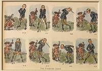
rif. 120757-092Original 1920 lithography bookillustration of golfers on a golf course. A golfer and a caddy with golfclubs. Lithography 145 x 195 in a bigger cardboard passepartout total size 235 x 295 mm. Nice gift for a lover of Golf. The illustration depicts a golfers failed attempts at making a proper shot. The cartoons charming style and expressive sequence capture the lighthearted frustration of early golfing culture.NL Originele lithografie met een golfer en zijn caddy met de titel The Undriven Drive. Engelse bookillustratie. Stripvorm. Satirisch humoristisch. Leuk cadeau voor een liefhebber van golf. Vintage sportcartoon. unknown
8vo. 9 pp. On three bifolia attached to one another with green string. A letter by a member of the British Consulate in Trieste, apparently written to a British official in Cyprus, responding to an enquiry regarding "the probable price of a pair of horses about 15 hands". "The kind of horses that you speak of are known here as 'Jukers', light, active, strong [...], fast trotting, able to go 14 kilometres an hour. A pair of horses of such description 5 years old & sound will cost about fls 1200 or say £100. Hungarian horses in my opinion will suit the best for your Island as they have Arab blood in them". The writer explains that he is not a dealer himself, "but being very fond of horses & having many native friends in India I have very often occasions to buy for them & also for my brother, who resides in Bombay at present". He explains that "no good horses are to be found in Trieste", and that "as a rule" he visits "the fairs in the interior" to buy horses. He names the four breeding farms of the Hungarian Government and describes the types of horses bred at each ("lastly the Fogaras stud, where stallions from the Lipizza private farm belonging to the Emperor are supplied"). Describes the auction of the "superfluous horses of these establishments of the age of 4 & 5" at "Tattersall's in Budapest in the 1st week of October", with prices for each type of horse, giving examples from his own experience. "Two British Cavalry officers belonging to the Egyptian Army came over here in the Autumn of 1896. They bought 60 remounts for the Egyptian cavalry. The Greek Cavalry & Artillery are wholly supplied with horses from Hungary". While discussing "sires for breeding purposes" he mentions that he knows "the Director of the Lipizza farm [...] personally" and gives the price at which he is offered superior horses by him. Ends with details of possible "charge for freight on each horse to Cyprus". - Text clear and complete.
Ink and watercolours on paper, backed with cloth. Calligraphic and armorial headpiece; historiated initials; two coloured illustrations (a hunter loading his gun; a hawk devouring a goose). Four red wax seals. 77 x 55 cms, rolled and stored in a contemporary marbled tube. A certificate of apprenticeship for the hunter Anton Spiallek (Spialleck) of Wiegstädtel near Opava in Silesia, signed by Franz Spialeck (possibly a relation) and four other district hunting officials of Dombrau and Mittel-Suchau (Prostrední Suchá), owned by Richard Baron Mattencloit. The art of hunting had long included falconry also in Silesia, and it was among the favourite pastimes of the nobility.
8vo. 14, (2) pp. With portrait frontispiece and folding Arabic facsimile. Original printed wrappers. Rare British pamphlet advertising the independence of Hejaz from Ottoman rule, following the Arab Revolt in which T. E. Lawrence had played so vital a role. Husayn strove for acknowledgement as "King of Arabia", though the powers would recognize him only as King of Hejaz. In 1924 Abd al-Aziz ibn Saud conquered Hejaz and proclaimed the Kingdom of Saudi Arabia six years later. - A clean, unmarked copy. Rare, the last copy at auction sold in 1999 (Sotheby's, Oct 14, 1999, lot 439, £800). OCLC 3949330.
Standard issue, 700 x 1024 mm. Scale 1:50,000. Detailed nautical chart of the approaches to Mina Salman, the primary cargo port and customs point of Bahrain, prepared by the British Admiralty. Undoubtedly one of the better antiquarian maps of northern Bahrain. - The chart details the approaches to Mina Salman as well as the Sitra anchorage. Approach channels to Mina Salman were built in 1954, and a pier was constructed in 1956, mainly used by dhows. In 1958 it became a free port, and in 1962 a deep water wharf composed of six berths was constructed. The wharf allowed cargo to be directly loaded onto the port for the first time. In the 1960s, the port had refrigeration, storage facilities and equipment for handling large ships. - The map includes the cities of Muharraq and Manama, showing numerous minarets. Bahrain Fort, the Portuguese Fort, Abu Mahur Fort, and the Sheikh's palace are labelled. Another prominent site is Muharraq Airfield, a military base established by the Royal Air Force in April 1943 as RAF Bahrain (later RAF Muharraq) that remained in use until 1971, when Bahrain declared independence. - The British Admiralty has produced nautical charts since 1795 under the auspices of the United Kingdom Hydrographic Office (HO). Its main task was to provide the Royal Navy with navigational products and service, but since 1821 it has also sold charts to the public. The present chart was composed after Admiralty surveys from 1932 to 1960. The 1951 first edition saw revisions and corrections in 1962-65. - Very well preserved with a single fold. Provenance: stamps of Maria K. Iatrou, seller of nautical charts, books and instruments in Piraeus, Greece.
Engraved map. 1230 x 690 mm. Detailed British Admiralty chart of the approaches to Jeddah, present-day Saudi Arabia, with an inset chart of Jeddah Harbour and the city itself. - This is undoubtedly one of the better antiquarian maps of the gateway city to Mecca and Medina. Jeddah was an important diplomatic city when the map was made; illustrated are the consulates of Britain, Russia, Austria, the Netherlands, Egypt, and France. Numerous minarets of the old city are shown. The old city walls and the gates of Mecca, Cherif, and Medina are labeled. The Ummina Howwa (Eve's Tomb) is shown. - At the beginning of the 20th century, Jeddah was an important Red Sea port, but with many islands and much shoaling in the approaches, it was a dangerous one. The British Admiralty has produced nautical charts since 1795 under the auspices of the United Kingdom Hydrographic Office (HO). Its main task was to provide the Royal Navy with navigational products and service, but since 1821 it has also sold charts to the public. In 1795, King George III appointed Alexander Dalrymple, a pedantic geographer, to consolidate, catalogue, and improve the Royal Navy’s charts. He produced the first chart as the Hydrographer to the Admiralty in 1802. Dalrymple, known for his sticky personality, served until his death in 1808, when he was succeeded by Captain Thomas Hurd. The HO has been run by naval officers ever since. Hurd professionalized the office and increased its efficiency. He was succeeded by the Arctic explorer Captain William Parry in 1823. By 1825, the HO was offering over 700 charts and views for sale. Under Parry, the HO also began to participate in exploratory expeditions. The first was a joint French-Spanish-British trip to the South Atlantic, a voyage organized in part by the Royal Society of London. In 1829, Rear-Admiral Sir Francis Beaufort was appointed Hydrographer Royal. Under his management, the HO introduced the wind force scale named for him, as well as began issuing official tide tables (1833). It was under Beaufort that HMS Beagle completed several surveying missions, including its most famous voyage commanded by Captain FitzRoy with Charles Darwin onboard. When Beaufort retired in 1855, the HO had nearly two thousand charts in its catalogue. Later in the 19th century, the HO supported the Challenger expedition, which is credited with helping to found the discipline of oceanography. The HO participated in the International Meridian Conference which decided on the Greenwich Meridian as the Prime Meridian. Regulation and standardization of oceanic and navigational measures continued into the 20th century, with the HO participating at the first International Hydrographic Organization meeting in 1921. During World War II, the HO chart making facility moved to Taunton, the first purpose-built building it ever inhabited. In 1953, the first purpose-built survey ship went to sea, the HMS Vidal. Today, there is an entire class of survey vessels that make up the Royal Navy’s Hydrographic Squadron. The HO began to computerize their charts in the late 1960s and early 1970s. In 1968, the compilation staff also came to Taunton, and the HO continues to work from there today.
Engraved chart. 760 x 1065 mm. Scale 1:23,594. Nautical chart including tidal information, compass roses, soundings, seabed notations, currents, sandbanks, shoals and inland elevations. Folded.
1320 x 865 mm. Scale 1:145,925. Nautical chart of the North Coast of Panama. Engraved chart, including tidal information, compass roses, soundings, seabed notations, currents, sandbanks, shoals, lighthouses and beacons picked out in yellow and red, inland elevations, detailing and buildings. First published in 1938, revised in 1948. Signs of contemporary use. Folded.
1147 x 850 mm. Scale 1:921,207. Engraved chart, including tidal information, compass roses, soundings, seabed notations. First published in 1898 from British Surveys to 1863. - Folded.
1290 x 780 mm. Lithographed with some lighthouses highlighted in purple. Scale 1:883,200. Serial no. 1588. New edition of the U.S. Navy's 1899/1931 hydrographic map of the Gulf of Oman, immediately east of the Musandam Peninsula to Karachi, showing depths and lighthouses on the coasts of Oman and Iran. Marked as 8th edition, March 1948, reprinted April 1951. - Stamp of Northwest Instrument Co., Inc., Agents, Seattle, in lower margin. Well preserved.
Standard issue, 710 x 1264 mm. Scale 1:24,300. Fine nautical chart of the port of Aden, historically a major hub of transportation for the region, prepared by the British Admiralty. Undoubtedly one of the better antiquarian maps of Aden under British administration. With a small panoramic view of the peninsulas of Aden and Little Aden. - The chart shows the Aden Peninsula with the city and harbour, as well as Little Aden peninsula and Bander Tauwahi. It details the port area, labeling the clock tower, the market, the cemetery, the Prince of Wales pier, police lines and telegraph stations, as well as Marbut Hill, Chapel Hill and Barrack Hill. It includes the mountainous Aden Peninsula and Gold Mohur Valley, as well as smaller islands such as Flint Island, Slave Island, and Sirah. On Little Aden the chart includes the Sheikh Ghadir temple as well as Mount Sugarloaf. In addition, the chart marks a quarantine area between both peninsulas for sea-going vessels. - The British Admiralty has produced nautical charts since 1795 under the auspices of the United Kingdom Hydrographic Office (HO). Its main task was to provide the Royal Navy with navigational products and service, but since 1821 it has also sold charts to the public. The present chart was composed after Admiralty surveys of 1906; it was first published in 1907 and saw several corrections up to 1936. - With two folds. A few manuscript notes. Slightly brownstained.
Standard issue, 698 x 1024 mm. Scale 1:6,120. Detailed nautical chart of the port of Aden, historically a major hub of transportation for the region, prepared by the British Admiralty. Undoubtedly one of the better antiquarian maps of Aden under British administration. - The chart details the port area, labelling the Hotel de l'Europe, churches, the post office, the American Consulate, Cunningham market, the Prince of Wales pier, coal wharfs and the Aden Coal Company, as well as Marbut Hill, Chapel Hill and Barrack Hill. It includes the mountainous Aden Peninsula and Gold Mohur Valley, as well as the quarantine station on Flint Island. - The British Admiralty has produced nautical charts since 1795 under the auspices of the United Kingdom Hydrographic Office (HO). Its main task was to provide the Royal Navy with navigational products and service, but since 1821 it has also sold charts to the public. The present chart was composed after Admiralty surveys between 1906 and 1936; it was first published in 1907 and saw several corrections up to 1937. - With a single fold. Captioned in print and in a former collector's hand on verso. Slightly brownstained near upper right corner and on lower right margin.
Standard issue, 710 x 1,236 mm. Scale 1:2,730,000. Nautical chart of the Gulf of Aden and the Arabian Sea including the west coast of India, prepared by the British Admiralty. The chart details the strait of Bab-el-Mandeb, the Gulf of Aden, Socotra Island and the open sea as well as the Somali coast and the Horn of Africa. Among the major labeled cities are Mokka, Aden, Masira, and Ras al Hadd in Arabia, as well as Bombay and Surat in India. The chart shows the boundary between the British and Italian spheres of interest in Africa and warns the mariner of approaching the eastern point of Socotra during the south-west monsoon. - The British Admiralty has produced nautical charts since 1795 under the auspices of the United Kingdom Hydrographic Office (HO). Its main task was to provide the Royal Navy with navigational products and service, but since 1821 it has also sold charts to the public. The present chart was composed after surveys by the East India Government between 1828 and 1863, as well as Indian navy surveys between 1836 and 1849; it was first published in 1899 and saw several corrections up to 1935. - With two folds; a few manuscript notes. With a stamp "Increase 50%" near lower right corner. Captioned in print and in a former collector's hand on verso. Larger and smaller tear in lower margin along the folds; small hole near lower margin; small dampstain near lower right corner.
1025 x 700 mm. Chart of Costa Rica, Panama, the Mosquito Gulf and the Pacific Ocean. Engraved chart, including tidal information, compass roses, soundings, seabed notations, currents, sandbanks, shoals, inland elevations, detailing and buildings. First published in 1889, revised in 1926. Signs of contemporary use, with several pencil markings. Folded.
1140 x 710 mm. Chart of the East Coast of Arabia from Ras Sukra to Palinurus Shoal with inset maps of Bander Reisut, Merbat Bay and Kishin Bay. Engraved chart, including tidal information, compass roses, soundings, seabed notations, currents, sandbanks, shoals, lighthouses and beacons picked out in yellow and red, inland elevations, detailing and buildings. Published by John Walker, Geographer to the East India Company in 1850, new editions in 1865, 1888, 1921 and 1924. Signs of contemporary use. Folded.
1025 x 700 mm. Scale 1:6120. Nautical chart of the Gulf of Aden with a handwritten note: "Caution: the depths on the northern side of the Inner Harbour are reported to be between 1 and 3 feet less than charted (1927)". Including tidal information, compass roses, soundings, seabed notations, currents, sandbanks, shoals, lighthouses and beacons picked out in orange, inland elevations, detailing and buildings.This edition first published in 1907, revised in 1926. Signs of contemporary use, with several pencil markings. Folded.
Standard issue, 814 x 1006 mm. Scale 1:712,000. Nautical chart of the Gulf of Aden including the Horn of Africa and Socotra Island, prepared by the British Admiralty. With three panoramic views featuring Ras Jard Hafún and its neighbouring hills. - The chart details the Arabian and African coasts, Abd al-Kuri, and the Socotra Islands. Among the major labeled places are Ras-al-Kalb, Mukalla, Shihr, and Ras Kusa'ir on the Arabian coast, as well as Ras Adado, Bandar Kassim, Alula, and Hafun on the African continent. The chart shows geological features, marking several limestone formations including Jebel Warsangeleh, and warns mariners of the somewhat outdated rendering of Cape Guardafui, and of approaching the eastern point of Socotra island during the south-west monsoon. - The British Admiralty has produced nautical charts since 1795 under the auspices of the United Kingdom Hydrographic Office (HO). Its main task was to provide the Royal Navy with navigational products and service, but since 1821 it has also sold charts to the public. The present chart was composed after surveys by the Indian navy as well as Admiralty surveys between 1836 and 1927; it was first published in 1886 and saw several corrections up to 1934. - Small marginal tear in the centrefold, pierced in one place. Slightly brownstained. Two folds. A few manuscript notes and stamp "Increase 50%" near lower right corner. Captioned in print and in a former collector's hand on verso.
Standard issue, 700 x 1025 mm. Constant ratio linear horizontal scale 1:800,000. Nautical chart of the Gulf of Aden with the Arabian and African shoreline, prepared by the British Admiralty. With a small view of Ras-al-Kalb mountain. The chart details the Gulf from the Red Sea and the strait of Bab-el-Mandeb in the west to the cities of Burum in Arabia and Bander Báad in Africa in the east. It shows Perim Island, the Gulf of Tajura, mountains like Jebel Arar and Jebel Fadthli, as well as tribal areas. Among the most prominent labelled cities are Mokka, Aden, Balhaf, Zeila, Berbera, and Las Khoreh. - The British Admiralty has produced nautical charts since 1795 under the auspices of the United Kingdom Hydrographic Office (HO). Its main task was to provide the Royal Navy with navigational products and service, but since 1821 it has also sold charts to the public. The present chart was composed after Admiralty surveys of 1836-48 and 1911; it was first published in 1888 and saw several corrections up to 1931. - With a single fold. A few manuscript notes. With a stamp "Increase 50%" near lower right margin. Captioned in print and in a former collector's hand on verso. Some small marginal tears in the centerfold; not touching image.
Standard issue, 700 x 1025 mm. Constant ratio linear horizontal scale 1:800,000. Nautical chart of the Gulf of Aden with the Arabian and African shoreline, prepared by the British Admiralty. With a small view of Ras-al-Kalb mountain. The chart details the Gulf from the Red Sea and the strait of Bab-el-Mandeb in the west to the cities of Burum in Arabia and Bander Báad in Africa in the east. It shows Perim Island, the Gulf of Tajura, mountains like Jebel Arar and Jebel Fadthli, as well as tribal areas. Among the most prominent labelled cities are Mokka, Aden, Balhaf, Zeila, Berbera, and Las Khoreh. - The British Admiralty has produced nautical charts since 1795 under the auspices of the United Kingdom Hydrographic Office (HO). Its main task was to provide the Royal Navy with navigational products and service, but since 1821 it has also sold charts to the public. The present chart was composed after Admiralty surveys of 1836-48 and 1911; it was first published in 1888 and saw several corrections up to 1934. - With a single fold. A few manuscript notes. With a stamp "Increase 50%" near lower right corner. Captioned in print and in a former collector's hand on verso. Slightly brownstained.
Standard issue, 710 x 1160 mm. Nautical chart of the Gulf of Suez from Suez to the Strait of Jabal, prepared by the British Admiralty. With two inset maps of the Ras Gharib anchorage and Abu Zenima Bay, as well as views of the Zafara and Ras Gharib lighthouses and the Sinai mountains with Mount Catherine. - The chart shows the Bay of Suez with the ports of Ibrahim and Thewfik and the maritime canal, as well as the Atakah mountains, the Zafarana plain and Mount Sinai. Among the most prominent labelled cities are Suez, Zafara, Abu Zenima, Ras Gharib, and El Tor. - The British Admiralty has produced nautical charts since 1795 under the auspices of the United Kingdom Hydrographic Office (HO). Its main task was to provide the Royal Navy with navigational products and service, but since 1821 it has also sold charts to the public. The present chart was composed after Admiralty surveys of 1871-72; it was first published in 1873 and saw several corrections up to 1933. - With two folds. With a stamp "Increase 50%" near lower right corner. A few manuscript notes. Captioned in print and in a former collector's hand on verso. Faint marginal flaws, not touching image; somewhat spotted.
Standard issue 516 x 688 mm. Scales 1:7,230 to 1:29,040. Nautical chart of ten of the principal harbours and anchorages of the Red Sea, prepared by the British Admiralty: Sherm Sheikh, Sherm el Moiyah, Mersa Diba, Sherm Habban, Omeider Island, Dahab, Sherm en Noman, Wasit anchorage, Akaba Bay, and Khor el Wahla. The chart of Akaba Bay shows Akaba City and the ruined fort as well as Victoria Pier and an observation spot. Several charts show dangerous coral reefs, including Harrier reef on the Khor el Wahla chart. - The British Admiralty has produced nautical charts since 1795 under the auspices of the United Kingdom Hydrographic Office (HO). Its main task was to provide the Royal Navy with navigational products and service, but since 1821 it has also sold charts to the public. The present chart was composed after surveys by the Austrian Imperial ship "Pola" in 1895-96, as well as an admiralty survey of 1918; it was first published in 1899 and saw several corrections up to 1921. - With a stamp "Increase 50%" near upper margin. Captioned in former collectors' hands on verso. Blueish smudge near upper margin; several small marginal tears, only one of which touching text.
Standard issue, 514 x 690 mm. Scales 1:8,250 and 1:94,700. Nautical chart of Perim Harbour, Beilul Bay and the Rakhmat Island anchorage in the Red Sea, prepared by the British Admiralty. The island of Perim divides the Strait of Mandeb into two channels. The island, as a dependency of Aden, was part of the British Empire between 1857 and 1967. - Perim encloses a deep and comparatively large natural harbour on the southwestern coast. The chart labels the pilot's and coal agent's houses, piers, coal stacks, the hospital, the Lloyd's signal station, and leisure facilities like a tennis court and a cricket ground. Other prominent places on the island include the fishing village of Meyun, Murray Point, William Bay, the old fort, and a parade ground. The two smaller maps of Beilul Bay and Rakhmat Island detail lava formations, mangroves, and swamps. - The British Admiralty has produced nautical charts since 1795 under the auspices of the United Kingdom Hydrographic Office (HO). Its main task was to provide the Royal Navy with navigational products and service, but since 1821 it has also sold charts to the public. The present chart was composed after Admiralty surveys of 1885; it was first published in 1886 and saw several corrections up to 1919. Captioned in former collectors' hands on verso.
109,5 x 195 cm. Mounted on cloth. Large nautical chart of the Indian Ocean from the Cape of Good Hope to Australia. It combines the western sheet (Cape of Good Hope to Cape Comorin) and the eastern sheet (Cape Comorin to Australia) on a single map with two title vignettes. The chart details the Arabian Peninsula with the Red Sea and the Gulf, the eastern coast of Africa, Madagascar, India, parts of China, Indonesia, and the entire continent of Australia. - The British Admiralty has produced nautical charts since 1795 under the auspices of the United Kingdom Hydrographic Office (HO). Its main task was to provide the Royal Navy with navigational products and service, but since 1821 it has also sold charts to the public. The present chart was first published in 1856 and saw several corrections up to 1867. - Some pencil notes. Cracked in several places; marginal flaws professionally repaired.
Standard issue, 690 x 850 mm. Scale 1:96,600; 1:96,800; 1:36,950. Nautical chart of some of the main islands in the Red Sea, displaying Jebel Jukur and the Hanish Islands, prepared by the British Admiralty. With 2 inset maps of the Zebayir Islands and the Abu Ali Channel. - The main chart details the 23 islands and rocks of the Hanish Islands, administered by the Italian colony of Eritrea from 1923 to 1941 (when Italy left Eritrea, administration was carried on by Britain). The Zabayir archipelago, featured on an inset map, is a group of 10 major volcanic islands rising on top of an underlying shield volcano and reaching a height of 191 metres above sea level. The second inset map of the Abu Ali Channel includes a large portion of Jebel Zukur. - The British Admiralty has produced nautical charts since 1795 under the auspices of the United Kingdom Hydrographic Office (HO). Its main task was to provide the Royal Navy with navigational products and service, but since 1821 it has also sold charts to the public. The present chart was composed after an Admiralty survey of 1881/2; it was first published in 1883 and saw several corrections up to 1928. - With a single fold; tear to lower margin, touching image; two small marginal tears, not touching image. A few manuscript notes. Stamped "Increase 50%" at lower margin. Captioned in print and in a former collector's hand on verso.