4.213 Ergebnisse
8vo. 31, (1) pp., with 47 pp. of black-and-white photo plates. Modern half cloth. Rare treatise on the various breeds of Arabian horses in the Ottoman Empire, a translation of the author's "Osmanli atlari", published in Istanbul the previous year. "I have decided to reissue my book in German because, as far as I know, the German language does not possess of an extensive and detailed account of the several horse breeds of Turkey, in especial of the Arabian horse and its various sub-breeds and strains. I was also encouraged by the great interest that Turkey evinces quite generally throughout Germany, and the close economic connexions between these two allied countries which we are to expect after the end of the war may also bring about closer relations in the field of horse breeding [...]" (preface). The copious plate section shows numerous breeds of Arabian horses. - Occasional brownstaining with the odd contemporary German annotation in copying pencil, but well preserved altogether. A single copy outside Germany (Catholic University of Paris); none in America (only a microfilm of the Tübingen copy at Harvard). Flugschrift der Deutschen Gesellschaft für Züchtungskunde 42. OCLC 72415601. Not in Boyd/Paul.
4to. 40 pp. Original printed wrappers. Stapled. Arabic edition of the leading English newspaper on oil matters. Founded in 1934, the Petroleum Press Service was one of the first reliable sources of information on all aspects of the petroleum industry and trade. The Arabic version, first issued in 1953, was published up to the 1970s. - Front cover slightly dampstained.
Folio (202 x 330 - 214 x 325 mm). Together 39 pp. Three typescript drafts in French and English of the 1957 Petroleum Act, a pioneering document of contractual relationships in the oil industry. The personal copies of Fuad Rouhani (1907-2004), later the first Secretary General of OPEC, with his annotations. - In the years immediately following the signing of the 1954 Consortium Agreement, the historic agreement that provided Western oil companies with 50% ownership in Iranian oil production, the fledgling national Iranian oil Industry received an enormous moral boost from the exploration activities conducted around Qom. The discovery of the Alborz oilfield and the Sarajeh gas field by the Iranian Oil Company not only proved Iran's growing technical capacity but it also helped to give Iran a prestige not hitherto enjoyed by any other oil producing and exporting country. Against this background it is therefore hardly surprising that when Enrico Mattei, the Chairman of ENI (the Italian State Oil Company), decided to look for oil supplies in the Middle East by offering new contractual terms, he should turn to Iran and that the government of Iran and the NIOC should greet him with open arms. What had prompted Mattei to come forward with the participation formula was his resentment at the treatment he had received from the major oil companies by being excluded from the Consortium Agreement. Since access to crude oil resources was of utmost importance for Italy and ENI, a way had to be found for entry into the Middle East oil scene. NIOC and ENI thus pioneered a new form of contractual relationship, thereafter known as 75/25 profit sharing, breaking the hallowed fifty-fifty arrangement and heralding a new era in international oil agreements. - Traces of stapling; margins somewhat worn.
8vo. 26, (2) pp. Later half morocco, spine gilt, with the original printed wrappers bound within. Schwerdt copy. One of 150 copies. - Spine rubbed. Schwerdt I, 103. Thiébaud 166.
8vo. 26, (1) pp., final blank page. Original printed wrappers. Only edition. One of only 150 copies of this treatise on falconry, which is in fact a reprint of the same treatise included in Briffardière's 1742 "Nouveau Traité de Vénerie" (pp. 383-401), which Pierre Clément de Chappeville published after the author's death. Apparently, the editor of the present edition confounded Chappeville with Briffardière, as it was the latter, not the former, who was appointed "Gentilhomme de la Vénerie du Roy", a title mistakenly given to Chappeville on the title-page. - Covers somewhat browned and brownstained; spine chafed; binding loosened. Margins slightly worn. Contemporary ownership of B. C. R. Langford, as well as a later ownership of Charles Henry Stanley Garton (b. 1920), dated Kingswood, September 1943, to front pastedown. Handwritten note on title-page regarding the confusion of authorship, likely by Garton. Schwerdt I, 103. Thiébaud 166. Harting 171. Souhart 367. OCLC 54185123.
Small 4to. 60, (6) pp. With 13 black and white photographic plates, 2 of which full-page, as well as a folding coloured map of Syria, Palestine and Egypt. First edition. - A compact guide to Syria, Palestine and Egypt before the inter-war period, written by the agent general of the French steamship company in the Middle East. Outlining the countries' history and recommending places to visit, it is illustrated with views of Beirut, Tripolis, Aleppo, Nazareth, and Cairo, as well as important landmarks, including the Great Mosque of Damascus, temples at Baalbek, Palmyra, the Sphinx and the pyramids, the Church of the Holy Sepulchre and the Wailing Wall. - Label of the Librairie Orientaliste Paul Geuthner in Paris to front cover. Upper wrapper somewhat foxed, spine and margins slightly worn. OCLC 7201775.
8vo. (2), VI, (4), 427, (6) pp. With engr. title portrait and 4 engr. plans (wants the map). Original illustrated green cloth with giltstamped spine. Seventh edition, abridged from the two-volume original edition. - This travelogue, recounting a journey across the Arabian Peninsula from Riadh to the Arabian Gulf, was highly esteemed at the time of its publication, though is now known to contain fictional passages. Palgrave disguised himself as a Syrian Christian doctor named Selim Abu Mahmoud al'Eis and spent 13 months travelling. - Some foxing. Cf. Macro 1731 (1865 first ed.). Henze III, 693. Howgego III, P5 (other eds.).
3 volumes. 8vo. XVI, 388 pp. (2), IV, 426 pp. XII, 448 pp. Half-title in vol. 3, without publisher's ads. 4 maps & plans (3 folding), 5 colour lithographed plates, 8 tinted lithographed plates. Later half morocco over marbled paper covered boards, bound by Zaehnsdorf, spine with raised bands in six compartments, lettered in the second and fourth, the others with a repeat decoration in gilt, marbled endpapers, top edge gilt. First edition of Burton's classic account of his journey across the Arabian peninsula. In the fall of 1852, Burton first proposed to the Royal Geographical Society an expedition to central Arabia with the intent on visiting the holy cities. His request was denied by the RGS and the East India Company as being too dangerous for a westerner, though he was funded to study Arabic in Egypt. Upon arrival there, in April 1853, disguised as a Pashtun and travelling under the pseudonym Mirza Abdullah, Burton made the pilgrimage to Mecca and Medina. "The actual pilgrimage began with a journey on camel-back from Cairo to Suez. Then followed twelve days in a pilgrim ship on the Red Sea from Suez to Yambu, the port of El-Medinah. So far the only risk was from detection by his companions. Now came the dangers of the inland road, infested by Bedawin robbers. The journey from Yambu to El-Medinah, thence to Meccah, and finally to the sea again at Jeddah, occupied altogether from 17 July to 23 Sept., including some days spent in rest, and many more in devotional exercises. From Jeddah, Burton returned to Egypt in a British steamer, intending to start afresh for the interior of Arabia via Muwaylah. But this second project was frustrated by ill-health, which kept him in Egypt until his period of furlough was exhausted. The manuscript ... was sent home from India, and seen through the press by a friend in England. It is deservedly the most popular of Burton's books ... as a story of bold adventure, and as lifting a veil from the unknown, its interest will never fade" (DNB). Indeed, the work would be described by T.E. Lawrence as "a most remarkable work of the highest value." Abbey, Travel 368. Penzer, pp. 43-50. Macro, 640. Howgego IV, B95.
Hand-coloured engraved map (740 x 555 mm). A fascinating 1804 map of Persia by Christian Gottlieb Reichard. It covers from the Black Sea south as far as the Gulf and east as far as Punjab in India, including the modern day nations of Iran, Iraq, Georgia, Armenia, Azerbaijan, Turkmenistan, Afghanistan and Pakistan. The map identifies numerous towns, villages, deserts, mountain ranges, river systems and a host of other topographical features. The map is color coded according to territories and boundaries. The map curiously divides the country, as the title suggests, into the Eastern and Western Empire, suggesting suspicious political evidence. Furthermore, the islands in the Gulf are also erroneously shown as independent territories, suggesting political aspirations of the time. The map represents Persia under the Qajar Dynasty. In 1794, Aga Muhammad Khan of the Qajar Dynasty overthrew Loft Ali Khan, the last Shah of the Zand Dynasty, and relocated the capital to the new city of Tehran. The subsequent era, the Qajar Dynasty, witnessed numerous military conflicts with the rising powers of Imperial Russia and the loss of much of Persia's territory. Al-Qasimi 218. Not in Tibbetts, Al Ankary.
Engraved map (35 x 50 cm), contemporarily hand-coloured and highlighted in gold. Scale 1:9,000,000. 16th century Dutch map of Persia based on the Gastaldi map, with additional new cartographic information. Van den Broecke 167 (first state). Alai, General maps E.70. Al-Qasimi 30.
8vo. (8), 83, (1) pp. (8), 57, (1) pp. (8), 74 pp. (8), 52 pp. (4), 26 pp., final blank f. (4), 26 pp. 38 pp. (index). Publisher's printed green cloth. A manual of "geographical, economic, historical, social, religious and political" information compiled for the British delegates to the Peace Conference that took place in Versailles in 1919, here issued "for public use" for the first time. The extensive section on the Arabian coastal regions includes not only detailed statistics (giving the population of Abu Dhabi, Dubai, and Sharjah at 6,000, 20,000, and 15,000 inhabitants, respectively), but also, in a separate appendix, the full text of the treaties signed between the United Kingdom and the Sheikhs and rulers of the "Trucial Coast" in 1820 and 1853, including the names of all signatories: Sh. Hassan bin Rahmah for Ras al-Khaimah, Sh. Shakbout for Abu Dhabi, Sh. Zayed bin Syf for Dubai, Sh. Sultan bin Suggur for Sharjah, Sh. Rashid bin Hamid for Ajman, Sh. Abdullah bin Rashid for Umm al-Quwayn, etc. - Issued as vol. XIII of the "Peace Handbooks" by the Historical Section of the Foreign Office. Comprises in all: nos. 76 (Persian Gulf), 77 (French India), 78 (French Indo-China), 79 (Portuguese India), 80 (Portuguese Timor), and 81 (Macao). - Binding slightly stained. Withdrawn from the University Library of Manchester (their ownership, bookplate, and deaccession stamp to endpapers). - Rare. OCLC 28122772.
Standard issue, 695 x 1025 mm. Scale 1:876,000. Fine nautical chart of the western portion of the Arabian Gulf. With 3 inset maps of Kharg and Khárgu, Jezirat Halul anchorage, and Sheikh Shu'aib, as well as 18 small panoramic coastal views. - The chart provides details of Qatar and Bahrein as well as of parts of Iran, Iraq, Kuwait, and Saudi Arabia. Major labelled localities include Basra, Kuwait and Kuwait Harbour, Bushire, Al Qatif, Doha and Muharraq. Further, the chart marks the Anglo-Persian oil pipeline as well as landmarks including Dilam fort and several tombs. - The British Admiralty has produced nautical charts since 1795 under the auspices of the United Kingdom Hydrographic Office (HO). Its main task was to provide the Royal Navy with navigational products and service, but since 1821 it has also sold charts to the public. The present chart was composed after Admiralty surveys between 1821 and 1934; it was first published in 1862 and saw several corrections up to 1948. - With a single fold. A few faint pencil notes. Upper left corner slightly creased.
990 x 760 mm. Scale 1 : 4000000. Third edition. Topographical map of the Arabian Gulf and surrounding area showing international boundaries, main cities and towns, roads, railways, islands, rivers, lakes, wetlands and other vegetation and terrain features. Extends from the Caspian Sea south to Mecca and from Cairo east to Meshed. Relief shown by contours, altitude tints and spot heights. Includes legend, index to adjoining sheets, administrative index, and bibliographical references. - Slightly creased.
Sheet 1: 1030 x 700 mm; sheet 2: 1220 x 710 mm; sheet 3: 1030 x 700 mm; sheet 4: 1030 x 700 mm; sheet 5: 1220 x 710 mm. Scale 1:25,000. Nautical chart of Shatt Al Arab on 5 sheets: sheet 1 showing the "Entrance to Shatt Al Arab", sheet 2 showing the "Inner Bar to Kabda Point", sheet 3 showing "Kabda Point to Abadan" with an inset map of Abadan, sheet 4 showing "Abadan to Tuwaila Island" with an inset map of Mohammerah Bar, and sheet 5 showing "Tuwaila Island to Coal Island" with an inset map of Basra and Ma'qil. Engraved chart, including tidal information, compass roses, soundings, seabed notations, currents, sandbanks, shoals, lighthouses and beacons picked out in yellow and red, inland elevations, detailing and buildings. First published in 1907, revised in 1932. Signs of contemporary use, with several pencil markings. Folded.
Sheet 1: 1065 x 760 mm; sheet 2: 1270 x 765 mm. Scale 1:25,000. Nautical chart of Shatt Al Arab on 2 sheets: sheet 1 showing the "Entrance to Shatt Al Arab" (3842) and sheet 2 showing the "Inner Bar to Kabda Point" (3843). Engraved chart, including tidal information, compass roses, soundings, seabed notations, currents, sandbanks, shoals, lighthouses and beacons picked out in red, inland elevations, detailing and buildings. First published in 1927, revised in 1944. Signs of contemporary use, with several pencil markings. Folded.
Two copies of two folding maps colour printed on both sides of a sheet of silk (103 x 78.5 cm) on a scale of ca. 1:1,000,000. The two maps (ONC-H-6 & ONC-H-7) show one continuous area. Rayon pilot's map of the Arabian Gulf region focusing on the Trucial States (modern United Arab Emirates), Qatar, Bahrain, Oman, Iran and Saudi Arabia, including the main oil installations. Items of specific interest to aircraft, such as airfields and even seaplane bases, are particularly listed. Warnings to stay within the specific flying routes while in Iran are placed on multiple locations. While the map depicts a continuous area on both sides of one sheet, it actually consists of two maps, originally published separately. We here include two copies so the whole area can be displayed at once. The maps are reproduced after the third and fourth edition. - In very good condition.
Map (67 x 98 cm). Lights and beacons highlighted in purple. Wartime reprint, “reproduced by the U.S. Hydrographic Office from British Admiralty Chart”. First issued in 1921, with changes in 1923, 1928, 1931, 1936, 1940, and 1943. Not in Al Ankary; Al-Qasimi.
1040 x 710 mm. Scale 1:350,000. Nautical chart of the Arabian Gulf off the coast of Ras Tanura on the north-eastern coast of the Arabian Peninsula, with parts of the southern coastline of Persia. Including tidal information, compass roses, soundings, seabed notations, currents, sandbanks, shoals, inland elevations (including a "conspicuous tree" on the island of Shaikh Shu'aib). This edition first published in 1955, with large corrections in 1958 and smaller ones in the subsequent years to 1964 (overstamped or handwritten). - Folded; some pencil annotations but very well preserved. Provenance: from the archives of Lilley & Reynolds Ltd., suppliers of Navigation Equipment.
Engraved map, hand coloured in outline. 535 x 371 mm. An English version of D'Anville's famous nautical chart of the Gulf from 1776. Although Bahrain is depicted, the large peninsula of Qatar is notably absent, and the coast between Bahrain and Abu Dhabi is marked "This Coast is not known". Al-Qasimi (2nd ed.), p. 236.
1040 x 710 mm. Scale 1:150,000. Nautical chart of the Arabian Gulf off the coast of Ras Tanura on the north-eastern coast of the Arabian Peninsula. Including tidal information, compass roses, soundings, seabed notations, currents, sandbanks, shoals, inland elevations. This edition first published in 1951, re-engraved in 1958, with revisions in 1962, 1963 and (overstamped or handwritten) 1964. - Folded; very well preserved. Provenance: from the archives of Lilley & Reynolds Ltd., suppliers of Navigation Equipment.
8vo. (2), L, 312, (2) pp. With several maps and plates. Original cloth. "The Persian Gulf Pilot contains sailing directions for the Persian gulf and the approaches thereto, from Ras al Hadd, in the south-west, to Cape Monze, in the East". - Also includes copious information on politics, population, languages, trade, currencies, pearl fishery, meteorological information (climate, winds, weather, temperature, humidity), as well as currents, tides, communications and other miscellaneous information. - Binding rubbed and faded. Only two copies in auction records of the past decades (Peter Hopkirk's copy fetching £1,300 at Sotheby's, Oct 14, 1998, lot 1043). Hydrographic Office Publication 158. OCLC 709448977. Cf. Wilson 171.
8vo. (2), L, 312, (2) pp. With several maps and plates. Original cloth. "The Persian Gulf Pilot contains sailing directions for the Persian gulf and the approaches thereto, from Ras al Hadd, in the south-west, to Cape Monze, in the East". - Also includes copious information on politics, population, languages, trade, currencies, pearl fishery, meteorological information (climate, winds, weather, temperature, humidity), as well as currents, tides, communications and other miscellaneous information. - Binding slightly rubbed. Only two copies in auction records of the past decades (Peter Hopkirk's copy fetching £1,300 at Sotheby's, Oct 14, 1998, lot 1043). Hydrographic Office Publication 158. OCLC 709448977. Cf. Wilson 171.
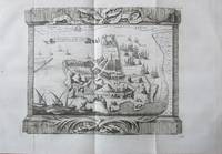
1747Best.-Nr. 143611747. Bellin Jacques Nicolas. Ile d'Ormus ou de Jerun 1747 depicts Hormuz and the surrounding Persian Gulf maritime landscape more than a century after an Anglo-Persian force ended Portuguese control of the island in 1622. Published in Histoire générale des voyages the engraving identifies the Persian coast islands anchorages fortifications and channels while distinguishing Arab vessels from large-masted European sailing ships. Its concentration on ships coastal defenses and approaches to Hormuz records the strategic geography of a passage that connected Persian Gulf ports with Indian Ocean trading routes. Bellin Jacques Nicolas. Ile d'Ormus ou de Jerun. From Histoire générale des voyages 1747. Overall sheet size 13.5 x 9.5 inches; image size 7.5 x 9.75 inches. The upper portion identifies the "Cote de Perse" while inscriptions throughout the engraving include "Fortresse" "Ile de Kishom ou Quixema" "Entre des Vaisseaux" "Porte de derriere" "Parade Alkoran" "St. Lucia" and "Lardimira." Five Arab vessels occupy the foreground while additional Arab shipping appears at left and European ships with tall masts and multiple sails appear at right. The fortified settlement on Hormuz includes the fortress associated with Portuguese occupation of the island. Hormuz had been seized in 1507 by the Portuguese commander Afonso de Albuquerque and Portuguese control made the island a fortified base for regulating maritime commerce at the entrance to the Persian Gulf. The Portuguese constructed the Fort of Our Lady of the Conception there; in 1622 forces of Shah Abbas I assisted by ships of the English East India Company captured Hormuz and ended Portuguese rule on the island. Bellin's 1747 engraving therefore records a landscape shaped by earlier Portuguese fortification but returned to Persian control while its juxtaposition of Arab and European vessels documents the continuing international maritime character of the strait. Paper folded three times consistent with its original publication format. Overall very good condition. unknown books
Coloured map (72 x 57 cm). Scale 1:4,055,040. Map of the Arabian Gulf. “It must have been drawn to show the zones of influence of Russia and Great Britain in Persia, as defined by the Anglo-Russian convention on 31st of august 1907” (Alai). Alai, General maps E.354. OCLC 221059917. Not in Al Ankary; Al-Qasimi.
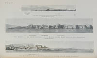
Best.-Nr. 112658London Hydrographic Department Admiralty 1955. . Tenth edition with the second supplement dated 1959; 8vo 24.5 x 16 cm; supplement loosely inserted at rear 4 coloured plates of diagrams two maps acting as an index for admiralty charts 16 double-sided plates showing numerous coastal views further in-text weather diagrams notice of supplement tipped in to face title; publisher's blue cloth lettered in yellow spine a little sunned joints professionally restored very good copy; l 312 1 pp. A scarce pilot guide of the Persian gulf describing Bahrain Kuwait Qatar Dubai and Abu Dhabi and numerous other villages and towns along the Arabian coast. Includes coastal views of Ras Al Hadd Sur Qalhat As Suwaiq Sohar Fujairah Khasab the Tunb Islands Abu Musa Sirri Island Al Jazirah Al Hamra Al Shebeakah Rams Ajman Qasr Al Hosn in Abu Dhabi Sir Bani Yas the Doha Fort Bahrain Harbour and Tarut Island amongst others. The guide was published to give accurate sailing directions to the ports towns and safe anchorages along the Arabian coast from Ras al Hadd on the eastern peninsular of Oman to Shatt al Arab in the North and back along the coast of Iran to Bandar Abbas and beyond. With much early information on the principal settlements of the United Arab Emirates Qatar Bahrain Kuwait and Oman and an interesting glossary of Arabic-English key terms. By 1955 it was clear how the oil boom had changed the economy of the region. The first chapter gives an overview and includes the character of the sea and ports description of major towns and cities and their respective populations for example 18000 in Qatar the main economic imports and exports of each locale and considerable weather information. Dubai is described as well as Daira: 'Daira is a large suburb consisting of mat huts amongst which stand a number of well-built houses.' 'Dibai Dubai contains the residence of the Shaikh. There are several tall towers in Dibai; the fort is a conspicuous square building with a round tower. from which the Shaikh's flag is displayed. There is a hospital.' Abu Dhabi is similarly described: 'This town consists for the most part of huts and extends along the coast for nearly two miles. In the town there is a small fort partially surrounded by trees with five towers close together. The coast in the vicinity of Abu Dhabi is very low and the beach is of white sand'. The fort is given it's own view on one of the plates. The great pearl bank is also given attention: 'this extensive bank. fills the great bight in the southern part of the Persian Gulf.' 'Many islands both close to the coast and far offshore lie on the bank. With the exception of Dalma none has permanent inhabitants though they are frequented by the pearl boats during the summer and by fisherman from Abu Dhabi in the winter.' 'The best pilots for the coast are to be obtained at Abu Dhabi.' Much detail is also given to Qatar and Doha: 'This town situated on the southern side of the harbour is the capital of Al Qatar peninsula and had a population in 1947 of about 12000.' ' The Shaik's palace. is a large building with many colonnades and an open balustrade round its roof.' ' The chief exports are gutch fish and pearls; imports are food timber and manufactured goods.' Bahrain is also described with Manama being called the 'principal town and port' and as well as the trade being described there is also note of the health of the region: 'Manama is more liable to epidemics than the smaller ports; since 1920 however there have been no more epidemics in Bahrain than in any other of the larger Gulf ports.' It is interesting also that one of the major changes of the supplement is changing the name 'Bahrein' to 'Bahrain'. Kuwait is described as greatly altered by the oil wealth: ' Wealth derived from oil revenues is being spent on completely replanning and rebuilding the town. Government offices schools hospitals electric generating and water distillation stations private houses and blocks of flats are all being built in the most modern style'. 'Pearl fishing is now practically extinct. There are to all intents and purposes no exports. The chief imports are food of all kinds machinery motor vehicles and building materials.' London, Hydrographic Department, Admiralty, 1955. hardcover