Laurence DunnAntiquariat.de
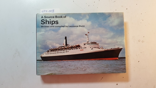
1973Best.-Nr. 472008London: Ward Lock Limited. 1973. 158 S. 12 x 17,5 cm. Zustand: Gut bis Sehr Gut min. gebräunt (Innen); Minischildchen (2x1cm) auf dem Vorsatzblatt, läßt sich wohl entfernen, mir gelang das einmal; Einband (Außen) hat min. Gebrauchsspuren; Schnitt unten min. angestaubt; Ppbd. mit Schutzumschlag
1847Best.-Nr. elala1004Toronto: 1847-59. 1847. 19th century half calf rubbed joints partly cracked. COMPRISING: Scobie & Balfours Canadian Almanac And Repository Of Useful Knowledge For The Year 1848 8vo. pp. 99 1index 4ads. folding lithographed map of Upper Canada based on a Canada Company map engraved by Arrowsmith. foxing & staining to outer leaves small hole in title with loss of last digit in imprint date several tears in map no loss. Toronto: Scobie & Balfour 1847. BOUND WITH: Scobie & Balfours Canadian Almanac And Repository of Useful Knowledge For The Year 1849 8vo. pp. 88. Toronto: Scobie & Balfour 1848.BOUND WITH: Scobie & Balfours Canadian Almanac And Repository of Useful Knowledge For The Year 1850 8vo. pp. 76. lithographed map of Upper Canada. outer margin of title chipped. Toronto: Scobie & Balfour 1849.BOUND WITH: Scobies Canadian Almanac And Repository of Useful Knowledge For The Year 1851 8vo. pp. 84. folding lithographed map of part of Canada West from 79 to 82 degrees W. & from 43 to 45 degrees N. Toronto: Hugh Scobie 1850. BOUND WITH: Scobies Canadian Almanac And Repository of Useful Knowledge For The Year 1852 8vo. pp. 96. folding lithographed map of part of Canada West showing the counties north of Lake Erie. Toronto: Hugh Scobie 1851. BOUND WITH: Scobies Canadian Almanac And Repository of Useful Knowledge For The Year 1853 8vo. pp. 95 1. folding lithographed map of part of Canada West showing counties north of Lake Ontario. Toronto: Hugh Scobie 1852. BOUND WITH: Scobies Canadian Almanac And Repository of Useful Knowledge For The Year 1854 8vo. pp. 88. folding lithographed map of part of Canada West between the St. Lawrence & the Ottawa River. Toronto: Hugh Scobie 1853. OFFERED WITH: The Canadian Almanac And Repository of Useful Knowledge For The Years 1855 to 1860. Compiled And Arranged Under The Direction Of The Publishers. 6 Parts with separate titles bound from the original parts. 8vo. pp. iv 88; 103 1; 103 1; 103 1; 95 1; 91 1. 5 folding lithographed maps none for year 1857: 1 map of Upper Canada based on map by William H. Smith 2 map of Canada East 3 map of Canada West 4 map of the County of Essex 5 map of Canada West showing locations of Post Offices. few tears in maps no loss. Toronto: Maclear & Co. 1859. TPL 2871. Toronto: 1847-59. unknown
Best.-Nr. 0656228466.Ghardcover. Good. Access codes and supplements are not guaranteed with used items. May be an ex-library book. hardcover
Best.-Nr. B9781013651021Hardback. New. hardcover
Best.-Nr. B9781013754142Hardback. New. hardcover
Best.-Nr. B9781013484049Hardback. New. hardcover
Best.-Nr. B9781013577321Hardback. New. hardcover
Best.-Nr. B9781013364976Hardback. New. hardcover
Best.-Nr. B9781013872754Hardback. New. hardcover
Best.-Nr. B9781013625572Hardback. New. hardcover
Best.-Nr. B9781013842504Hardback. New. hardcover
Best.-Nr. B9781013677021Hardback. New. hardcover
Best.-Nr. B9781013794841Hardback. New. hardcover
Best.-Nr. B9781013921513Hardback. New. hardcover
Best.-Nr. B9781013664991Hardback. New. hardcover
Best.-Nr. B9781013963308Hardback. New. hardcover
Best.-Nr. B9781013456268Hardback. New. hardcover
Best.-Nr. B9781013399480Hardback. New. hardcover
Best.-Nr. B9781015381612Hardback. New. hardcover
Best.-Nr. B9781013417122Hardback. New. hardcover
Best.-Nr. B9781013900310Hardback. New. hardcover
Best.-Nr. B9781013379420Hardback. New. hardcover
Best.-Nr. B9781013847431Hardback. New. hardcover
Best.-Nr. B9781013735042Hardback. New. hardcover
Best.-Nr. B9781013401190Hardback. New. hardcover


