9 659 résultats
1810réf. 68974Philadelphia: Published by C. & A. Conrad & Co. 1810. Philadelphia: Published by C. & A. Conrad & Co. 1810. Full Description: PIKE Zebulon Montgomery. An Account of Expeditions to the Sources of the Mississippi. and through the Western Parts of Louisiana to the Sources of the Arkansaw Kans La Platte and Pierre Juan Rivers; Performed by the Order of the Government of the United States during the Years 1805 1806 and 1807. And a Tour through the Interior Parts of New Spain When Conducted through these Provinces by Order of the Captain-General in the Year 1807. Illustrated by Maps and Charts. Philadelphia: Published by C. & A. Conrad & Co. 1810. First edition of the first United States government expedition to the Southwest and one of the most important of all American travel narratives. Octavo 8 1/2 x 5 1/4 inches; 216 x 135 mm. 5 1 blank 1 1 blank 105 1 blank 9 Meteorological Observations 1 blank 107-277 3 blank 2 Meteorological Observations 65 1 53 1 blank 87 1 blank pp. Stipple-engraved frontispiece portrait of Pike by Edwin and with six engraved maps and charts five of which are folding and three folding letterpress tables. Full contemporary sheep. Spine with repairs along hinges and head and tail piece. Black leather spine label lettered in gilt. Edges speckled brown. Boards with some minor rubbing and chipping. Some light foxing and toning throughout. The second letterpress chart with a two-inch closed tear at the margin but with no loss. Overall a very good copy and much better than usually found. This important expedition was made as part of a concerted effort by President Jefferson to explore the newly acquired territory west of the Mississippi. Leaving the St. Louis area in July 1806 Pike explored Kansas Oklahoma Northern Texas the Spanish settlements of New Mexico and Colorado until captured by the Spanish. Conducted through Santa Fé to Chihuahua he was returned through Texas to Louisiana. All of Pike's papers were confiscated but he managed to save his precious journals by secreting them amongst his men. When published in 1810 the narrative offered the first accurate description of the great Southwest. The maps were the first to exhibit a geographic knowledge of the Southwest based on first hand exploration and are considered "milestones in the mapping of the American West" Wheat. Graff 3290. Howes P373 "First government exploration of the Southwest". Sabin 62936. Streeter 3125. Streeter Texas 1047. Wagner-Camp 9:1. Wheat Transmississippi West 297 298 and 299. HBS 68974. $13500. Published by C. & A. Conrad, & Co... unknown books
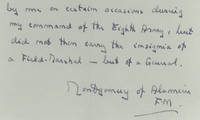
réf. 36125Mar-68. Acquired by us from the recipient these have never before been offered for sale An extraordinary memento of the war from one of its most prominent leaders Allied uniform elements almost never reach the market these being true rarities embedhttps://vimeo.com/1180585334share=copy&fl=sv&fe=ci/embed Bernard Law Montgomery known as ""Monty"" was the most prominent British field marshal during World War II. His most notable achievements include commanding the British Eighth Army at the pivotal Battle of El Alamein in 1942 which marked a significant turning point in the North African campaign. Montgomery remained an influential figure in military history earning the title of Field Marshal Lord Montgomery of Alamein in 1946. He published several works on military strategy and leadership before retiring from public life in 1968. In August 1942 Montgomery was named as the new commander of the British Eighth Army. After he assumed command he continued preparations for what promised to be a decisive battle with Erwin Rommel’’s famed Africa Corps. The Battle of El Alamein which began on October 23 was the type of set-piece engagement at which Montgomery excelled. His victory there represented the crowning achievement of his military career and shattered the mythical invincibility of the German army. With his “Desert Rats” in pursuit of the “Desert Fox” the world was soon to become familiar with the Montgomery image. Locked inside his small wiry frame was a reservoir of energy and an abundance of self-confidence. After the North African theater was cleared in May 1943 Montgomery led his forces in the invasion of Sicily July 1943 and later in the invasion of Italy September 1943. During the course of the Italian campaign he was recalled to England to assist in the planning of the Normandy invasion over which he was given tactical command. He commanded all Allied ground forces during the initial phase of the Battle of Normandy Operation Overlord from June 6 to September 1 1944. Then after Dwight D. Eisenhower was named Supreme Allied Commander Montgomery led the 21st Army Group and implemented a strategy of drawing German armored forces toward the British/Canadian sector at Caen enabling the U.S. breakout in the west. Montgomery continued to command the 21st Army Group through the rest of the campaign in North West Europe. When the war in Europe came to an end Montgomery was placed in charge of the British zone of occupation in Germany a post he held until February 1946 when he succeeded General Alan Brooke as chief of the Imperial General Staff. Autograph letter signed on his letterhead Hampshire March 1968 sending the shoulder strap and insignia he wore on his uniform during World War II. “This shoulder strap with the insignia of a Field Marshal is from a uniform worn by me in Europe on certain ceremonial occasions after my promotion to the rank of Field Marshall on 1st September 1944 and as Commander-in-Chief of the ground forces under SHAEF Supreme Headquarters Allied Expeditionary Force. The actual uniform was also worn by me on certain occasions during my command of the Eighth Army but did not then carry the insignia of a Field Marshal but of a General.” It is signed “Montgomery of Alamein F.M.” The shoulder strap and colorful insignia are included. An extraordinary memento of World War II from one of its most prominent leaders. We’ve never had anything like it before. <img class=""alignnone wp-image-25018 size-post-window"" src=""https://cdn.raabcollection.com/wp-content/uploads/20231204144051/Folder-site-11-1600x1327.jpg"" alt=""historical memorabilia dealer"" width=""1600"" height=""1327"" /> unknown
réf. 36125Mar-68. Acquired by us from the recipient these have never before been offered for sale An extraordinary memento of the war from one of its most prominent leaders Allied uniform elements almost never reach the market these being true rarities embedhttps://vimeo.com/1180585334share=copy&fl=sv&fe=ci/embed Bernard Law Montgomery known as ""Monty"" was the most prominent British field marshal during World War II. His most notable achievements include commanding the British Eighth Army at the pivotal Battle of El Alamein in 1942 which marked a significant turning point in the North African campaign. Montgomery remained an influential figure in military history earning the title of Field Marshal Lord Montgomery of Alamein in 1946. He published several works on military strategy and leadership before retiring from public life in 1968. In August 1942 Montgomery was named as the new commander of the British Eighth Army. After he assumed command he continued preparations for what promised to be a decisive battle with Erwin Rommel’’s famed Africa Corps. The Battle of El Alamein which began on October 23 was the type of set-piece engagement at which Montgomery excelled. His victory there represented the crowning achievement of his military career and shattered the mythical invincibility of the German army. With his “Desert Rats” in pursuit of the “Desert Fox” the world was soon to become familiar with the Montgomery image. Locked inside his small wiry frame was a reservoir of energy and an abundance of self-confidence. After the North African theater was cleared in May 1943 Montgomery led his forces in the invasion of Sicily July 1943 and later in the invasion of Italy September 1943. During the course of the Italian campaign he was recalled to England to assist in the planning of the Normandy invasion over which he was given tactical command. He commanded all Allied ground forces during the initial phase of the Battle of Normandy Operation Overlord from June 6 to September 1 1944. Then after Dwight D. Eisenhower was named Supreme Allied Commander Montgomery led the 21st Army Group and implemented a strategy of drawing German armored forces toward the British/Canadian sector at Caen enabling the U.S. breakout in the west. Montgomery continued to command the 21st Army Group through the rest of the campaign in North West Europe. When the war in Europe came to an end Montgomery was placed in charge of the British zone of occupation in Germany a post he held until February 1946 when he succeeded General Alan Brooke as chief of the Imperial General Staff. Autograph letter signed on his letterhead Hampshire March 1968 sending the shoulder strap and insignia he wore on his uniform during World War II. “This shoulder strap with the insignia of a Field Marshal is from a uniform worn by me in Europe on certain ceremonial occasions after my promotion to the rank of Field Marshall on 1st September 1944 and as Commander-in-Chief of the ground forces under SHAEF Supreme Headquarters Allied Expeditionary Force. The actual uniform was also worn by me on certain occasions during my command of the Eighth Army but did not then carry the insignia of a Field Marshal but of a General.” It is signed “Montgomery of Alamein F.M.” The shoulder strap and colorful insignia are included. An extraordinary memento of World War II from one of its most prominent leaders. We’ve never had anything like it before. <img class=""alignnone wp-image-25018 size-post-window"" src=""https://cdn.raabcollection.com/wp-content/uploads/20231204144051/Folder-site-11-1600x1327.jpg"" alt=""historical memorabilia dealer"" width=""1600"" height=""1327"" /> unknown books
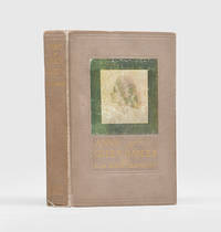
1908réf. 176171Boston: L. C. Page & Company 1908. It's delightful when your imaginations come true isn't it First edition of the author's first novel correctly dated April 1908 on the copyright page for the first printing. It was an immediate best-seller and new printings appeared nearly every month for the next two years. "Mark Twain wrote to congratulate Montgomery on the accidental adoptee Anne Shirley - 'the dearest and most moving child since the immortal Alice'" Grolier. Copies have been noted in various colours of cloth without priority. Octavo. Frontispiece with tissue guard and 7 plates. Publisher's 8-page adverts at end. Original pinkish-brown cloth spine and front cover lettered in gilt pictorial label and blind rules on front cover fore and bottom edges untrimmed. Contemporary laundry discount voucher loosely inserted. Loan label of William Boeringer Straube 1873-1958 to front pastedown; also with offsetting label sometime removed from front free endpaper with surface wear. Faint spots to spine minor wear to ends and corners joints and label rubbed tiny chip to upper left corner of label front inner hinge partially split remaining sound trivial short split to rear inner hinge marks to a couple of earlier leaves closed marginal tear to pp. 51/2. A very good copy. Grolier Children's 100 58; Peter Parley to Penrod p. 124. hardcover
1810réf. 40869Philadelphia: C. and A. Conrad and Co. of Philadelphia; Somervell and Conrad of Petersborough; Bonsal Conrad and Co. of Norfolk; and Fielding Lucas Jr. of Baltimore. Printed by John Binns 1810. Text: 8vo 8 1/2 x 4 3/4 inches. Atlas: 4to 10 1/2 x 11 inches. Text: 2 1-277 5 1-65 1 1-53 1 1-87 1. 492 pp. Engraved frontispiece portrait of Pike Letterpress Title Deposit Statement To the Public To the President Pike's Expeditions Part I-III Appendices to Parts I-III. Atlas: 6 engraved maps 5 of which are folding. 3 folding tables. Text volume in contemporary tree calf expertly re-backed to style spine in six gilt-ruled compartments with gilt calf lettering-piece in second gilt date in sixth and blind center tool in rest. Atlas volume in contemporary quarter calf with tips over original blue paper boards with printed paper label spine in seven gilt-ruled compartments with gilt red morocco lettering-piece in second gilt date in sixth and blind center tool One of the most important of all American travel narratives; Pike's account contains the first maps to incorporate geographical knowledge of the Southwest based on first-hand exploration. It is a milestone in the mapping of the American West. Wheat Here in the rarest and most desirable form with the plates and maps in a quarto atlas. Pike's narrative along with that of Long and Lewis and Clark is one of the most significant early books on the exploration of the American West. As such it is a cornerstone of Western Americana. In particular Streeter felt its "description of Texas is excellent." Hill gives the following summary of its contents: "In 1805 Pike was given the difficult assignment of conducting a reconnaissance of the upper Mississippi region. He was ordered to explore the headwaters of that river to purchase sites from the Indians for further military posts and to bring a few influential chiefs back to St. Louis for talks. The trip was only moderately successful as a mission to the tribes but Pike was able to convey important geographical information to President Jefferson and other Washington officials. On Pike's second expedition 1806-1807 he was assigned to explore the headwaters of the Arkansas River then proceed south and descend the Red River from its source. Pike and his men were taken into custody by a Spanish patrol and Pike was able to observe many areas in New Mexico Chihuahua and Texas. His book created interest in the Southwest and stimulated the expansionist movement in Texas." The atlas volume consists of the following maps plus three tables: 1. "Falls of St. Anthony." 2. "Map of the Mississippi River from its Source to the Mouth of the Missouri laid down from the notes of Lieutn Z. M. Pike by Anthony Nau. Reduced and Corrected by Astronomical observations of Mr. Thompson at its source; and of Captn. M. Lewis where it receives the waters of the Missouri." 3. "The First Part of Captn. Pike's Chart of the Internal Parts of Louisiana. 40 miles to the inch by Anthony Nau." 4. "Map of the Internal Provinces of New Spain. The outlines are from the Sketches of but corrected and improved by Captain Zebulon M. Pike who was conducted through that Country in the year 1807 by Order of the Commandant General of those Provinces." 5. "A Chart of the Internal Part of Louisiana. Including all hitherto unexplored Countries lying between the River La Platte of the Missouri on the N: and the Red River on the S: the Mississippi East and the Mountains of Mexico West; with a part of New Mexico and the Province of Texas. By Z. M. Pike Captn U. S." 6. "A Sketch of the Vice Royalty Exhibiting the several Provinces and its Approximation to the Internal Provinces of New Spain." Tables: 1. "Recapitulation of Furs and Peltries Fond du Lac department Marks and Numbers as per margin. North West Company 1804-5." 2. "Abstract of the number &c. of the Nations of Indians residing on the Mississippi and its confluent streams from St. Louis Louisiana to its source including Red lake and Lower Red river." 3. "A Statistical Abstract of the nations of Indians who inhabit that part of Louisiana visited by captain Z. M. Pike in his tour of discovery in that country in the years 1806 and 1807." Bradford 4415. Braislin 1474. Field 1217. Graff 3290. Hill 1357 2004. Howes P373 "Best Issue." Jones 743. Rittenhouse 467. Sabin 62836. Schwartz and Ehrenberg p.225. Streeter sale 3125. Streeter Texas 1047C. Wagner-Camp 9:1. Wheat Transmississippi 297 298 299. C. and A. Conrad, and Co. of Philadelphia; Somervell and Conrad of Petersborough; Bonsal, Conrad, and Co. of Norfolk; and Fieldi unknown
1810réf. 40869Philadelphia: C. and A. Conrad and Co. of Philadelphia; Somervell and Conrad of Petersborough; Bonsal Conrad and Co. of Norfolk; and Fielding Lucas Jr. of Baltimore. Printed by John Binns 1810. Text: 8vo 8 1/2 x 4 3/4 inches. Atlas: 4to 10 1/2 x 11 inches. Text: 2 1-277 5 1-65 1 1-53 1 1-87 1. 492 pp. Engraved frontispiece portrait of Pike Letterpress Title Deposit Statement To the Public To the President Pike's Expeditions Part I-III Appendices to Parts I-III. Atlas: 6 engraved maps 5 of which are folding. 3 folding tables. Text volume in contemporary tree calf expertly re-backed to style spine in six gilt-ruled compartments with gilt calf lettering-piece in second gilt date in sixth and blind center tool in rest. Atlas volume in contemporary quarter calf with tips over original blue paper boards with printed paper label spine in seven gilt-ruled compartments with gilt red morocco lettering-piece in second gilt date in sixth and blind center tool One of the most important of all American travel narratives; Pike's account contains the first maps to incorporate geographical knowledge of the Southwest based on first-hand exploration. It is a milestone in the mapping of the American West. Wheat Here in the rarest and most desirable form with the plates and maps in a quarto atlas. Pike's narrative along with that of Long and Lewis and Clark is one of the most significant early books on the exploration of the American West. As such it is a cornerstone of Western Americana. In particular Streeter felt its "description of Texas is excellent." Hill gives the following summary of its contents: "In 1805 Pike was given the difficult assignment of conducting a reconnaissance of the upper Mississippi region. He was ordered to explore the headwaters of that river to purchase sites from the Indians for further military posts and to bring a few influential chiefs back to St. Louis for talks. The trip was only moderately successful as a mission to the tribes but Pike was able to convey important geographical information to President Jefferson and other Washington officials. On Pike's second expedition 1806-1807 he was assigned to explore the headwaters of the Arkansas River then proceed south and descend the Red River from its source. Pike and his men were taken into custody by a Spanish patrol and Pike was able to observe many areas in New Mexico Chihuahua and Texas. His book created interest in the Southwest and stimulated the expansionist movement in Texas." The atlas volume consists of the following maps plus three tables: 1. "Falls of St. Anthony." 2. "Map of the Mississippi River from its Source to the Mouth of the Missouri laid down from the notes of Lieutn Z. M. Pike by Anthony Nau. Reduced and Corrected by Astronomical observations of Mr. Thompson at its source; and of Captn. M. Lewis where it receives the waters of the Missouri." 3. "The First Part of Captn. Pike's Chart of the Internal Parts of Louisiana. 40 miles to the inch by Anthony Nau." 4. "Map of the Internal Provinces of New Spain. The outlines are from the Sketches of but corrected and improved by Captain Zebulon M. Pike who was conducted through that Country in the year 1807 by Order of the Commandant General of those Provinces." 5. "A Chart of the Internal Part of Louisiana. Including all hitherto unexplored Countries lying between the River La Platte of the Missouri on the N: and the Red River on the S: the Mississippi East and the Mountains of Mexico West; with a part of New Mexico and the Province of Texas. By Z. M. Pike Captn U. S." 6. "A Sketch of the Vice Royalty Exhibiting the several Provinces and its Approximation to the Internal Provinces of New Spain." Tables: 1. "Recapitulation of Furs and Peltries Fond du Lac department Marks and Numbers as per margin. North West Company 1804-5." 2. "Abstract of the number &c. of the Nations of Indians residing on the Mississippi and its confluent streams from St. Louis Louisiana to its source including Red lake and Lower Red river." 3. "A Statistical Abstract of the nations of Indians who inhabit that part of Louisiana visited by captain Z. M. Pike in his tour of discovery in that country in the years 1806 and 1807." Bradford 4415. Braislin 1474. Field 1217. Graff 3290. Hill 1357 2004. Howes P373 "Best Issue." Jones 743. Rittenhouse 467. Sabin 62836. Schwartz and Ehrenberg p.225. Streeter sale 3125. Streeter Texas 1047C. Wagner-Camp 9:1. Wheat Transmississippi 297 298 299. C. and A. Conrad, and Co. of Philadelphia; Somervell and Conrad of Petersborough; Bonsal, Conrad, and Co. of Norfolk; and Fieldi unknown books
1908réf. 261983Boston: Page 1908. First. hardcover. very good. Illustrated by M.A. and W.A.J. Claus. 8vo pinkish gray cloth pictorial cover label. Boston: Page 1908. First Edition. First issue dated April 1908 on the copyright page with 8 page publisher's catalogue at the rear. Variant binding most copies being in green or tan cloth. The binding is lightly rubbed & soiled and there is an ownership signature but this is a solid internally fine copy of the very rare first issue of Montgomery's first novel. Page unknown
1908réf. 261983Boston: Page 1908. First. hardcover. very good. Illustrated by M.A. and W.A.J. Claus. 8vo pinkish gray cloth pictorial cover label. Boston: Page 1908. First Edition. First issue dated April 1908 on the copyright page with 8 page publisher's catalogue at the rear. Variant binding most copies being in green or tan cloth. The binding is lightly rubbed & soiled and there is an ownership signature but this is a solid internally fine copy of the very rare first issue of Montgomery's first novel. Page unknown books
1908réf. 35564Boston: L. C. Page and Co. 1908. First Edition. Author's first book and most famous work. This copy in a very early issue of the dustjacket with advertisements for titles published by Page no later than 1909 at the rear panel. Differs from the Cameron Treleaven copy in the titles listed at rear panel. A sharp Very Good plus copy expertly and unnoticeably recased with few pages showing paper acidity browning few pages with a dime sized brown stain few smudges to pages. Dustjacket has some browning scotch tape at verso light staining to spine shallow chipping to spine ends and panels. L. C. Page and Co.