1842Best.-Nr. 322045Paris: Ernest Bourdin 1842. hardcover. very good. CHARLET Nicolas-Toussaint. Two volumes. Illustrated abundantly in black and white. vii 828; 955 pages. Large 8vos bound in older 1/2 polished red calf backed marbled boards with decorative gilding and black spine labels spines lightly crackled some shelf wear and visible repairs to corners. Paris: Ernest Bourdin 1842. Scattered foxing otherwise internally clean and tight. A very good copy of this attractive set. Ernest Bourdin unknown books
1895Best.-Nr. 363744Paris: Garnier Freres Libraires-Editeurs 1895. Hardcover. Good. 1895 edition. Two volume set. Quartos. Unprinted black textured cloth. Decorative spray on page edges. Illustrated with two hundred and forty color drawings by L. Bombled. Text in French. Foxing to page edges and endpapers and title pages gutters cracked last page in volume one torn in half one inch tear on top edges of last few pages also in volume one spines browned and large stains on front boards thus good only. Advertisements in rear. First published in 1823 Emmanuel de Las Cases has collected the memories of Napoleon Bonaparte during almost daily talks with the Emperor during his stay in St. Helena. The Memorial of St. Helena lays the foundation of Bonapartism. Garnier, Freres, Libraires-Editeurs hardcover books
1824Best.-Nr. 349851824. hardcover. very good. 8 volumes. Thick 12mo 1/2 brown calf marbled boards and endpapers. Paris: Depot du Memorial 1824. Very good. Classic exhaustively detailed account of the Little Corporal's last months in exile. unknown books
1826Best.-Nr. 48018Carlsruhe: Johan Velten 1826. hardcover. very good. Folio. Worn but sturdy marbled boards with expert repairs in cloth to spine and corners; some hinges have also been restored. Includes elaborate title page dedication page preface to German edition 43 hinged hand-colored sheets 24 maps and 19 tables. Some light toning and foxing throughout. Carlsruhe: Johann Velten 1826. First German edition of the popular French atlas. Phillips List of Geographical Atlases #3550. Title translates to: "Historical-genealogical-geographical Atlas of Le Sage Count Las Cases in three and thirty-fold surveys translated from French of the latest edition into German and augmented with two political-geographical surveys by Alexandre von Dusch". Emmanuel-Augustin-Dieudonné-Joseph comte de Las Cases 1766-1842 was a French atlas-maker aka Le-Sage and author. Johan Velten unknown books
1818Best.-Nr. 316794London: Printed by R. Juigné 17 Margaret Street Cavendish Square 1818. Second Edition augmented with a map of Europe Showing its presewnt divisons as settled by the Congress of Vienna. With 39 double page plates and with six additional maps tipped in. Title page not present plate XIII America bound out of order. 1 vols. Folio 18 x 16 inches approx. Recent half deerskin and marbled boards. Original printed title label Price £4.4s mounted on upper board. Second Edition augmented with a map of Europe Showing its presewnt divisons as settled by the Congress of Vienna. With 39 double page plates and with six additional maps tipped in. Title page not present plate XIII America bound out of order. 1 vols. Folio 18 x 16 inches approx. Attractively bound copy of this standard early nineteenth century compendium of historical charts and historical geography. With six additional historical maps tipped in: Map of Great Britain according to the Itereray of Antoninus T. Lodge sculp. ca. 1750. Alexander's Expedition E. Bowen sculp. Expedition of Cyrus E. Bowen sculp. A Map of the Retreat of the Ten Thousand. Asia Minor for the Ancient History of Mr. Rollin R.W. Seale sculp. A map of the Nordic lands. Printed by R. Juigné, 17, Margaret Street, Cavendish Square unknown books
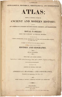
1821Best.-Nr. 25077Philadelphia: M. Carey and Sons Printed by T.H. Palmer on Ramage's Ruthven Press and on J. & T. Gilpin's Machine Paper 1821. Handsome American Atlas "From the last London edition.enlarged by the addition of several new maps of American History and Geography extended to the beginning of the year 1821. Third American edition carefully revised and corrected." A massive work attempting to chronicle the history of the world region by region including brief accounts of important navigations and maps of the various regions and of the world. Contains a handsome double-page map of the United States by John Melish with Texas shown as a separate territory. Folio. Modern half morocco and marbled boards. Titlepage soiled and somewhat chipped at edge with library perforation stamp. Neat reinforcements in gutters of most leaves. Maps and charts are very clean. Except for the titlepage just about very good. SABIN 39125. PHILLIPS ATLASES 132. hardcover books