Las CasesBiblio.com

121 résultats
1968réf. 73768Seuil Coll l'Intégrale 1968. Book. Very Good. Hardcover. 8vo - over 7¾" - 9¾" tall. In-8 relié jaquette Très Bon Etat . Seuil Coll l'Intégrale Hardcover
1961réf. 050017Garnier Frères, Editeur reliure Rigide Décorative Paris 1961 texte établi avec introduction, bibliographie et notes par andré fugier - 308 pages en format 12 - 20 cm - 8 gravures hors texte - reliure rigide en simili cuir avec encadrements et titre en dorure - TBE
1961réf. 008669Garnier Frères, Editeur reliure Rigide Décorative Paris 1961 texte établi avec introduction, bibliographie et notes par andré fugier - 589 pages en format 12 - 20 cm - 8 gravures hors texte - reliure rigide en simili cuir avec encadrements et titre en dorure - tbe
réf. 400020883Sans date.
1961réf. 2378Editions Garnier - Collège De France 11,5 x 18,5 Paris 1961 Deux volumes, brochés, jaquettes illustrées à rabats, Paris, Coll. "Classiques Garnier", forts In-12, LIV (introduction)-910 + 940 pages (avec index et tables des matières). Texte établi, avec introduction, bibliographie et notes par André Fugier, couvertures jaunes imprimées en rouge et noir, sans jaquettes. Illustrations en noir hors-texte. Petites tâches sur les tranches et les jaquettes, dos, couvertures et intérieur en bon état. Bon exemplaire. Livre
1961réf. 2378Editions Garnier - Collège De France 11,5 x 18,5 Paris 1961 Deux volumes, brochés, jaquettes illustrées à rabats, Paris, Coll. "Classiques Garnier", forts In-12, LIV (introduction)-910 + 940 pages (avec index et tables des matières). Texte établi, avec introduction, bibliographie et notes par André Fugier, couvertures jaunes imprimées en rouge et noir, sans jaquettes. Illustrations en noir hors-texte. Petites tâches sur les tranches et les jaquettes, dos, couvertures et intérieur en bon état. Bon exemplaire. Livre
réf. 500328094Sans date.
réf. R160213282Henri Gautier. non daté. In-12. Broché. Etat d'usage, Couv. légèrement pliée, Dos frotté, Papier jauni. 36 pages. . . . Classification Dewey : 235-Les saints
réf. FR14160PHOTOS SUR DEMANDE
réf. ria9783368625740_inpPaperback. New. New Book; Fast Shipping from UK; Not signed; Not First Edition; Unveränderter Nachdruck der Originalausgabe von 1899. paperback
réf. ria9783368625757_inpHardcover. New. New Book; Fast Shipping from UK; Not signed; Not First Edition; Unveränderter Nachdruck der Originalausgabe von 1899. hardcover
1939réf. feb1222421939. Used. For more details please contact me unknown
1935réf. 240506Hachette 1935 248 pages in12. 1935. Broché. 248 pages.
réf. 52164Geographia / éditeur à confirmer ,1892 env., in-8 256 pages ,Portrait-frontispice. Antoine-Amédée-Marie-Vincent Manca-Amat de Vallombrosa, connu sous son titre de Marquis de Morès, (14 juin 1858 - 9 juin 1896) militant antisémite et nationaliste français, explorateur, aventurier, éleveur de troupeaux et fondateur de la ville américaine de Medora (Dakota du Nord). En 1894 il se rend en Algérie pour y créer le Parti antisémite algérien. Il écida de se rendre en 1896 en Tunisie et organiser une caravanne vers la frontière lybienne pour influencer en faveur de la France la confrérie des Senoussis. Lexpédition tourna mal et il fut tué dans des circonstances peu laires le 9 juin au lieu-dit El Ouatia à la frontière de la Tunisie et de la Libye. Sa femme Medora von Hofmann et ses amis soupçonnèrent les ennemis politique du marquis davoir commandité son assassinat, mais le procès des exécutants napporta rien ,Broché ,Etat correct ,1 carte dépliante. . manque au dos .(4 photos du livre sur mon site https://www.vieuxlivre.fr) .Les frais de port pour la France sont offerts à partir de 25 euros d'achat (Mondial relay ). (colissimo suivi +6,90 ).
1808réf. 55974(Paris, Didot L'Ainé), 1808 (1805-06). Folio. (54 x 39 cm.). Contemp. hcalf. Wear to spine. Spine-ends repaired. Corners bumped.Titlelabel with gilt lettering on upper cover. (2) pp. , (recto: Atlas historique.- verso: Index, listing 32), Engraved frontispiece: Les Fastes Napoléens de 1796, a 1808, with a small handcoloured map, dated 1808. With 34 double-page uncut sheets (ca. 53 x 72 cm.) of which 16 are in letterpress text, handcoloured, 18 sheets are maps surrounded by text, all handcoloured. Internally clean and fine in original colouring. Map-sheets dated 1805-06. The frontispiece having a dampstain.
1841réf. LFA-126719090Un ouvrage de 583 pages, format 195 x 280 mm, illustré de nombreuses gravures en taille-douce sur acier d'après les dessins de M. de Sainson, dessinateur du voyage de l'Astrolabe, et de Jules Boilly + 2 cartes dépliables, relié cartonnage dos cuir orné, publié en 1841, Firne et Cie Libraires-Editeurs (Paris), bon état
1818réf. 316794London: Printed by R. Juigné 17 Margaret Street Cavendish Square 1818. Second Edition augmented with a map of Europe Showing its presewnt divisons as settled by the Congress of Vienna. With 39 double page plates and with six additional maps tipped in. Title page not present plate XIII America bound out of order. 1 vols. Folio 18 x 16 inches approx. Recent half deerskin and marbled boards. Original printed title label Price £4.4s mounted on upper board. Second Edition augmented with a map of Europe Showing its presewnt divisons as settled by the Congress of Vienna. With 39 double page plates and with six additional maps tipped in. Title page not present plate XIII America bound out of order. 1 vols. Folio 18 x 16 inches approx. Attractively bound copy of this standard early nineteenth century compendium of historical charts and historical geography. With six additional historical maps tipped in: Map of Great Britain according to the Itereray of Antoninus T. Lodge sculp. ca. 1750. Alexander's Expedition E. Bowen sculp. Expedition of Cyrus E. Bowen sculp. A Map of the Retreat of the Ten Thousand. Asia Minor for the Ancient History of Mr. Rollin R.W. Seale sculp. A map of the Nordic lands. Printed by R. Juigné, 17, Margaret Street, Cavendish Square unknown books
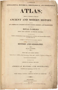
1821réf. 25077Philadelphia: M. Carey and Sons Printed by T.H. Palmer on Ramage's Ruthven Press and on J. & T. Gilpin's Machine Paper 1821. Handsome American Atlas "From the last London edition.enlarged by the addition of several new maps of American History and Geography extended to the beginning of the year 1821. Third American edition carefully revised and corrected." A massive work attempting to chronicle the history of the world region by region including brief accounts of important navigations and maps of the various regions and of the world. Contains a handsome double-page map of the United States by John Melish with Texas shown as a separate territory. Folio. Modern half morocco and marbled boards. Titlepage soiled and somewhat chipped at edge with library perforation stamp. Neat reinforcements in gutters of most leaves. Maps and charts are very clean. Except for the titlepage just about very good. SABIN 39125. PHILLIPS ATLASES 132. hardcover books
1821réf. 25077Philadelphia: M. Carey and Sons Printed by T.H. Palmer on Ramage's Ruthven Press and on J. & T. Gilpin's Machine Paper 1821. Handsome American Atlas "From the last London edition.enlarged by the addition of several new maps of American History and Geography extended to the beginning of the year 1821. Third American edition carefully revised and corrected." A massive work attempting to chronicle the history of the world region by region including brief accounts of important navigations and maps of the various regions and of the world. Contains a handsome double-page map of the United States by John Melish with Texas shown as a separate territory. Folio. Modern half morocco and marbled boards. Titlepage soiled and somewhat chipped at edge with library perforation stamp. Neat reinforcements in gutters of most leaves. Maps and charts are very clean. Except for the titlepage just about very good. SABIN 39125. PHILLIPS ATLASES 132. hardcover
1818réf. 316794London: Printed by R. Juigné 17 Margaret Street Cavendish Square 1818. Second Edition augmented with a map of Europe Showing its presewnt divisons as settled by the Congress of Vienna. With 39 double page plates and with six additional maps tipped in. Title page not present plate XIII America bound out of order. 1 vols. Folio 18 x 16 inches approx. Recent half deerskin and marbled boards. Original printed title label Price £4.4s mounted on upper board. Second Edition augmented with a map of Europe Showing its presewnt divisons as settled by the Congress of Vienna. With 39 double page plates and with six additional maps tipped in. Title page not present plate XIII America bound out of order. 1 vols. Folio 18 x 16 inches approx. Attractively bound copy of this standard early nineteenth century compendium of historical charts and historical geography. With six additional historical maps tipped in: Map of Great Britain according to the Itereray of Antoninus T. Lodge sculp. ca. 1750. Alexander's Expedition E. Bowen sculp. Expedition of Cyrus E. Bowen sculp. A Map of the Retreat of the Ten Thousand. Asia Minor for the Ancient History of Mr. Rollin R.W. Seale sculp. A map of the Nordic lands. Printed by R. Juigné, 17, Margaret Street, Cavendish Square unknown
1818réf. 2272Leipzig, F. A. Brockhaus, 1818. Gr.-8°. 120 S. - Angebunden: [Friedrich Arnold] BROCKHAUS. Darf Macklot in Stuttgart mir, dem rechtmäßigen Verleger, und dem Privilegium seines eigenen Königs zum Hohn, das Conservations-Lexicon zum zweiten Mal nachdrucken? Eine Warnung ... (Leipzig, 15. Juli 1818.) S. 1-16 (von 24) und 1 Bl.: Anzeige den Stuttgarter Nachdrucker Carl Erhard, genannt Macklot betreffend. Priv. Pappband mit Rückenschild.