Nathaniel Cutler / Edmond HalleyBiblio.com
2 231 résultats
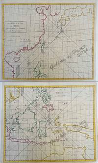
1728réf. 56704/56705hand-coloured copper engravings. Condition: with centerfold as issued. EXTREMELY RARE a very special and difficult to find maps from Atlas Maritimus & Commercialis: or a General View of the World for J. & J. Knapton W. & J. Innys London. The chart specially features the Philippines. The Atlas Maritimus can be used as an index of English trading activity at this period since detailed insets and harbour plans emphasize those areas of greatest commercial significance. Although the author of the text is anonymous Daniel Defoe is thought to have contributed to it and Halley the Astronomer-Royal added a prefatory note discussing the use of the charts; it is therefore sometimes catalogued under his name. It has also been attributed to Harris Senex and Wilson whose name appears on one chart. John Senex was certainly responsible for one of the atlas's innovations the globular chart of Western Europe whose projection according to the title-page was "authorized by letters patent". The atlas was purely commercial and was not a real rival to the 'English Pilot'. J. & J. Knapton, W. & J. Innys, London
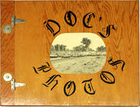
réf. 17571Idaho: n.p. 1980. Fine in lightly varnished plywood boards bound with two metal hinges along the spine gutter with a photograph adhered to the front cover. Unique vernacular photo album and scrapbook detailing the small town racing culture of Rupert Idaho. Extraordinarily lavish in size and execution the album features photographs by Dr. Elvin Cutler a photography hobbyist of local notoriety recognized for his images of the Minidoka Speedway its drivers and attendees. Includes 89 original color and black-and-white photographs ranging in size from snapshots to 8 x 10 inches with several larger format prints. Many have been signed by the photographer with his nickname "Doc;" several others have been annotated with humorous captions written underneath. The book was assembled by members of the town's Magic Valley Stock Car Racing Association MVSCRA and presented to Cutler as a sign of their gratitude and appreciation for his relentless documentation of the Minidoka Speedway with various pieces of ephemera including newspapers clippings and flyers from the racetrack adhered to the album's pages. Contents are housed in an extravagant handmade plywood album hinged and bolted along the spine gutter. A remarkable collection of amateur photography and a vibrant portrait of one of the defining pastimes and national obsessions of small town USA notable for its stunning photographic compositions and idiosyncratic homespun design. [Idaho: n.p. unknown
1980réf. 17571Idaho: n.p. 1980. Fine in lightly varnished plywood boards bound with two metal hinges along the spine gutter with a photograph adhered to the front cover. Unique vernacular photo album and scrapbook detailing the small town racing culture of Rupert Idaho. Extraordinarily lavish in size and execution the album features photographs by Dr. Elvin Cutler a photography hobbyist of local notoriety recognized for his images of the Minidoka Speedway its drivers and attendees. Includes 89 original color and black-and-white photographs ranging in size from snapshot to 8 X 10 inches with several larger format prints. Many have been signed by the photographer with his nickname "Doc"; several others have been annotated with humorous captions written underneath. The book was assembled by members of the town's Magic Valley Stock Car Racing Association and presented to Cutler as a sign of their gratitude and appreciation for his relentless documentation of the Minidoka Speedway with various pieces of ephemera including newspapers clippings and flyers from the racetrack adhered to the album's pages. Contents are housed in an extravagant handmade plywood book hinged and bolted along the spine gutter. A remarkable collection of amateur photography and vibrant portrait of one of the defining pastimes and national obsessions of small town USA notable for its stunning photographic compositions and idiosyncratic homespun design. Fine in lightly varnished plywood boards bound with two metal hinges along the spine gutter with a photograph adhered to the front cover. [Idaho: n.p. unknown books
1956réf. 237H5282Norman OK U.S.A.: University of Oklahoma Press. Good in Fair dust jacket. 1956. Second Printing. Hardcover. Second printing of the 1955 first edition. pp. viii 246. Index. "A well-planned public relations program says Edward L. Bernays U.S. Publicist Number 1 is executed in accordance with scientific principles. This book is based on the findings of social scientists whose dispassionate approach and methods may be likened to those of the engineering professions. A systematic presentation of the principal organizational problems in any public relations undertaking." - dust jacket. Unmarked with moderate wear to publisher's navy blue cloth brilliantly lettered in silver along backstrip. Tight and square. One-inch opening to fore-edge of pages 45-48. Above-average wear to dust jacket now preserved in archival-grade Brodart. A public relations classic. 8.7" x 5.5". Larson 8.; 8vo - over 7¾" - 9¾" tall; Spin Control Media Manipulation Marketing Public Relations Mind Control Thought Control Brainwashing Social Engineering Publicity Social Science Mass Mind . University of Oklahoma Press hardcover
1728réf. 236366London: James Knapton 1728. hardcover. Two parts in one volume. Illustrated with 53 of 54 fine uncolored copper plate maps last celestial chart is missing with a full size facsimile version provided from the British Library edition and 5 fold-out diagrams tipped into the second text. Title page printed in black and red foreword preface list of subscribers and list of charts. Dedication page has a repair to the margin. "Atlas maritimus & commercialis" 340 pp. plus index. "General Coasting Pilot" 195 pp. plus maps. Page numbers written in ink. Elephant folio 21.25" x 13" scuffing and corner wear to original brown leather binding gilt spine in 8 compartments. Some toning and light scattered foxing to text and maps. Repairs to World Chart North America chart and Celestial map along bottom fold out small abrasion in margin of China map. Bookplate pasted down with Coat of Arms of Verney. This commercial sea atlas was published in 1728 as a guide to British global commerce. Today it is a historically significant English overview of world trade during a rapid period of development of the British Empire's trading power. The atlas consists of two parts. The first is the "Atlas Maritimus & Commercialis" proper which provides a geographical overview of the world as it relates to trade and navigation. It also gives an account of contemporary commerce including the traded commodities of each country. The second part is "A General Coasting Pilot" by Nathaniel Cutler which provides sailing directions. The volume was published anonymously though the maps are often attributed to Sir Edmond Halley the Astronomer Royal of Britain who also wrote the prefatory note discussing the charts' use. The atlas's emphasis on commerce in addition to geography distinguishes it from "The English Pilot" the period's standard in maritime charts. It was also notable for covering the entire globe including the south and west coasts of America in one volume. This is an early issue of the Atlas with A Chart of the Coast of Scotland on a globular projection. London: 1728. Sir Edmond Halley 1656--1742 was an English astronomer geophysicist mathematician meteorologist and physicist known for computing the orbit of the eponymous Halley's Comet. He was the second Astronomer Royal in Britain after John Flamsteed. John Senex 1678-1740 was a kind of Renaissance man of the 18th-century map world working at times as a scholar surveyor engraver astrologer book seller and publisher of maps atlases and globes. In a short period he developed from an apprentice into one of the most important cartographers of the period and became a Fellow of the Royal Society of London as well as Official Geographer to Queen Anne of Great Britain. A wonderful rarity about 'Globular Projection" maps which was invented by Halley Harris and Senex. Includes the unforgettable large four sheet map "A Chart of the Atlantick Ocean Shewing the Coast from Texel to C. Cantin". James Knapton unknown books
1728réf. 236366London: James Knapton 1728. hardcover. Two parts in one volume. Illustrated with 53 of 54 fine uncolored copper plate maps last celestial chart is missing with a full size facsimile version provided from the British Library edition and 5 fold-out diagrams tipped into the second text. Title page printed in black and red foreword preface list of subscribers and list of charts. Dedication page has a repair to the margin. "Atlas maritimus & commercialis" 340 pp. plus index. "General Coasting Pilot" 195 pp. plus maps. Page numbers written in ink. Elephant folio 21.25" x 13" scuffing and corner wear to original brown leather binding gilt spine in 8 compartments. Some toning and light scattered foxing to text and maps. Repairs to World Chart North America chart and Celestial map along bottom fold out small abrasion in margin of China map. Bookplate pasted down with Coat of Arms of Verney. This commercial sea atlas was published in 1728 as a guide to British global commerce. Today it is a historically significant English overview of world trade during a rapid period of development of the British Empire's trading power. The atlas consists of two parts. The first is the "Atlas Maritimus & Commercialis" proper which provides a geographical overview of the world as it relates to trade and navigation. It also gives an account of contemporary commerce including the traded commodities of each country. The second part is "A General Coasting Pilot" by Nathaniel Cutler which provides sailing directions. The volume was published anonymously though the maps are often attributed to Sir Edmond Halley the Astronomer Royal of Britain who also wrote the prefatory note discussing the charts' use. The atlas's emphasis on commerce in addition to geography distinguishes it from "The English Pilot" the period's standard in maritime charts. It was also notable for covering the entire globe including the south and west coasts of America in one volume. This is an early issue of the Atlas with A Chart of the Coast of Scotland on a globular projection. London: 1728. Sir Edmond Halley 1656--1742 was an English astronomer geophysicist mathematician meteorologist and physicist known for computing the orbit of the eponymous Halley's Comet. He was the second Astronomer Royal in Britain after John Flamsteed. John Senex 1678-1740 was a kind of Renaissance man of the 18th-century map world working at times as a scholar surveyor engraver astrologer book seller and publisher of maps atlases and globes. In a short period he developed from an apprentice into one of the most important cartographers of the period and became a Fellow of the Royal Society of London as well as Official Geographer to Queen Anne of Great Britain. A wonderful rarity about 'Globular Projection" maps which was invented by Halley Harris and Senex. Includes the unforgettable large four sheet map "A Chart of the Atlantick Ocean Shewing the Coast from Texel to C. Cantin". James Knapton unknown