Cutler, Thomas JBiblio.com

2189 risultati
rif. DADAX1612519741New unknown
rif. 0070149968.Gtextbook. Good. Access codes and supplements are not guaranteed with used items. May be an ex-library book. unknown
rif. 1020968842.Ghardcover. Good. Access codes and supplements are not guaranteed with used items. May be an ex-library book. hardcover
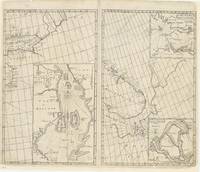
rif. 86034J. & J. Knapton W. & J. Innys London 1728. . Four engraved sea charts on one double-page map sheet. Good condition. Dimensions: 50 x 61 cm. Published in the 'Atlas maritimus & commercialis: or a General View of the World so far as Relates to Trade & Navigation'. The Atlas maritimus can be used as an index of English trading activity at this period since detailed insets and harbour plans emphasise those areas of greatest commercial significance. Although the author of the text is anonymous Daniel Defoe is thought to have contributed to it and Halley the Astronomer-Royal added a prefatory note discussing the use of the charts; it is therefore sometimes catalogued under his name. It has also been attributed to Harris Senex and Wilson those name appears on one chart. Senex was certainly responsible for one of the atlas's innovations the globular chart of Western Europe whose projection according to the title-page was "authorized by letters patent". The atlas was purely commercial and was not a real rival to the 'English Pilot': unlike the Pilot it compressed global coverage into one book as well as describing the the south and west coast of America omitted by the former. [J. & J. Knapton, W. & J. Innys, London, 1728]. unknown
1728rif. 268137London: James and John Knapton 1728. unbound. Sea Chart. Uncolored engraving.19 x 22 1/2 inches. This beautiful early sea chart of the Coromandel coast in Southeast India covers the entire eastern coast of India as well as the western coast of Burma Myanmar and southern Thailand. Extends from modern day Kanyakumari north to include the Ganges River Delta the coast of Bangladesh and then south along western coast of Burma or Myanmar to Thailand. The northern parts of Sri Lanka or Ceylon are also included. The chart notes several villages and settlements along the coast. Islands coastal features rhumb lines and other geographical features are also noted. The Coromandel Coast was one of the most important regions for the British Dutch French Danish and Portuguese during this time as much of the Indian trade was controlled through its various harbors and ports. This chart was made by Senex for the 1728 issued of "Atlas maritimus & commercialis or A general view of the world so far as relates to trade and navigation". The atlas which was meant to compete with Mount and Page's popular "English Pilot" was a collaboration between some of the leading cartographers of the time including Sir Edmund Halley John Senex Nathaniel Cutler Steven Parker and Daniel Defoe. The atlas unfortunately failed to achieve commercial success as great as its rival making this a hard-to-find map. The map is in good condition with minor wear along the original centerfold and overall toning. Map is lined with archival paper. John Senex 1678-1740 was a kind of Renaissance man of the 18th-century map world working at times as a scholar surveyor engraver astrologer book seller and publisher of maps atlases and globes. In a short period he developed from an apprentice into one of the most important cartographers of the period and became a Fellow of the Royal Society of London as well as Official Geographer to Queen Anne of Great Britain. Although well regarded for his pocket-size maps Senex is probably best known for his globes which display a knowledge of astronomy equal to the skill of their craftsmanship. After his death in 1740 his wife Mary continued his business and continued to produce and sell cartographic works of high quality. Together their work represents a successful and valuable partnership in 18th-century mapmaking and publishing. Sir Edmond Halley 1656--1742 was an English astronomer geophysicist mathematician meteorologist and physicist known for computing the orbit of the eponymous Halley's Comet. He was the second Astronomer Royal in Britain after John Flamsteed. Globular Projection maps were invented by Halley Harris and Senex. This is a wonderful example of their collaborative work. James and John Knapton unknown
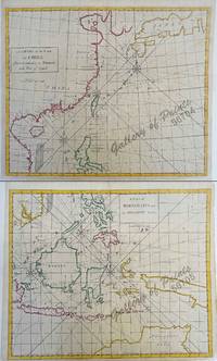
1728rif. 56704/56705hand-coloured copper engravings. Condition: with centerfold as issued. EXTREMELY RARE a very special and difficult to find maps from Atlas Maritimus & Commercialis: or a General View of the World for J. & J. Knapton W. & J. Innys London. The chart specially features the Philippines. The Atlas Maritimus can be used as an index of English trading activity at this period since detailed insets and harbour plans emphasize those areas of greatest commercial significance. Although the author of the text is anonymous Daniel Defoe is thought to have contributed to it and Halley the Astronomer-Royal added a prefatory note discussing the use of the charts; it is therefore sometimes catalogued under his name. It has also been attributed to Harris Senex and Wilson whose name appears on one chart. John Senex was certainly responsible for one of the atlas's innovations the globular chart of Western Europe whose projection according to the title-page was "authorized by letters patent". The atlas was purely commercial and was not a real rival to the 'English Pilot'. J. & J. Knapton, W. & J. Innys, London
1728rif. 268137London: James and John Knapton 1728. unbound. Sea Chart. Uncolored engraving.19 x 22 1/2 inches. This beautiful early sea chart of the Coromandel coast in Southeast India covers the entire eastern coast of India as well as the western coast of Burma Myanmar and southern Thailand. Extends from modern day Kanyakumari north to include the Ganges River Delta the coast of Bangladesh and then south along western coast of Burma or Myanmar to Thailand. The northern parts of Sri Lanka or Ceylon are also included. The chart notes several villages and settlements along the coast. Islands coastal features rhumb lines and other geographical features are also noted. The Coromandel Coast was one of the most important regions for the British Dutch French Danish and Portuguese during this time as much of the Indian trade was controlled through its various harbors and ports. This chart was made by Senex for the 1728 issued of "Atlas maritimus & commercialis or A general view of the world so far as relates to trade and navigation". The atlas which was meant to compete with Mount and Page's popular "English Pilot" was a collaboration between some of the leading cartographers of the time including Sir Edmund Halley John Senex Nathaniel Cutler Steven Parker and Daniel Defoe. The atlas unfortunately failed to achieve commercial success as great as its rival making this a hard-to-find map. The map is in good condition with minor wear along the original centerfold and overall toning. Map is lined with archival paper. John Senex 1678-1740 was a kind of Renaissance man of the 18th-century map world working at times as a scholar surveyor engraver astrologer book seller and publisher of maps atlases and globes. In a short period he developed from an apprentice into one of the most important cartographers of the period and became a Fellow of the Royal Society of London as well as Official Geographer to Queen Anne of Great Britain. Although well regarded for his pocket-size maps Senex is probably best known for his globes which display a knowledge of astronomy equal to the skill of their craftsmanship. After his death in 1740 his wife Mary continued his business and continued to produce and sell cartographic works of high quality. Together their work represents a successful and valuable partnership in 18th-century mapmaking and publishing. Sir Edmond Halley 1656--1742 was an English astronomer geophysicist mathematician meteorologist and physicist known for computing the orbit of the eponymous Halley's Comet. He was the second Astronomer Royal in Britain after John Flamsteed. Globular Projection maps were invented by Halley Harris and Senex. This is a wonderful example of their collaborative work. James and John Knapton unknown books
1993rif. 41270Livingston MT: Clark City Press 1993. First Edition. Staplebound wraps. Very good. Octavo 22.6 cm pp. 36. Tan cardstock wraps with brown titling and the Russell Chatham drawing of a woodcock which was the publisher's device for Clark City Press. Printed in two colors on textured paper. A sampling of excerpts from books scheduled for publication by Clark City Press but ultimately unpublished including Red and Blue Days by Matthiessen Sworn Before Cranes by Gilfillan The Massacre at Sand Creek by Cutler and Go by Go by Jackson. Gilfillan Cutler and Jackson's books were eventually published by other presses; however this work by Mattiessen has remained unpublished making the excerpt found here the only published version available. Slight shelf wear and soiling to wraps else fine. Clark City Press paperback books
1993rif. 41271Livingston MT: Clark City Press 1993. First Edition. Staplebound wraps. Very good. Octavo 22.6 cm pp. 36. Tan cardstock wraps with brown titling and the Russell Chatham drawing of a woodcock which was the publisher's device for Clark City Press. Printed in two colors on textured paper. A sampling of excerpts from books scheduled for publication by Clark City Press but ultimately unpublished including Red and Blue Days by Matthiessen Sworn Before Cranes by Gilfillan The Massacre at Sand Creek by Cutler and Go by Go by Jackson. Gilfillan Cutler and Jackson's books were eventually published by other presses; however this work by Mattiessen has remained unpublished making the excerpt found here the only published version available. Staining and soiling to wraps else fine. Clark City Press paperback books
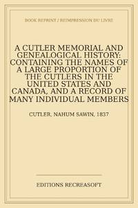
2026rif. LRB2003522Paris: Editions Recreasoft 2026 Language: English. Approximately 746 pages. English : Print-on-demand reprint. Original edition : 1889. A detailed genealogical and memorial history of the Cutler family in the United States and Canada tracing numerous individual branches and allied families by marriage. Of particular interest to researchers in genealogy family history and American local and social history with an index for easier consultation. Book images are non-contractual. Editions Recreasoft. Softcover. New. Editions Recreasoft paperback
2026rif. LRB48059150Paris: Editions Recreasoft 2026 Language: English. Approximately 750 pages. English: Print-on-demand reprint. Original edition : 1889. Text in English. This comprehensive genealogical work provides an extensive record of the Cutler family in the United States and Canada documenting their history lineage and connections through marriage to other prominent families. The volume includes detailed genealogical information biographical sketches and historical accounts making it a valuable resource for genealogists and historians interested in early American and Canadian family histories. Book images are non-contractual. Editions Recreasoft. Softcover. New. Editions Recreasoft paperback
rif. 45238397-nnew. unknown
rif. 45238397like new. unknown
rif. 44963886-nnew. unknown
rif. 44963886like new. unknown
rif. 1437017959.Ghardcover. Good. Access codes and supplements are not guaranteed with used items. May be an ex-library book. hardcover
rif. 1015486150.Ghardcover. Good. Access codes and supplements are not guaranteed with used items. May be an ex-library book. hardcover
rif. 101549126X.Gpaperback. Good. Access codes and supplements are not guaranteed with used items. May be an ex-library book. paperback
rif. 1169981208.Gpaperback. Good. Access codes and supplements are not guaranteed with used items. May be an ex-library book. paperback
rif. 1164522663.Gpaperback. Good. Access codes and supplements are not guaranteed with used items. May be an ex-library book. paperback
rif. 1164816829.Ghardcover. Good. Access codes and supplements are not guaranteed with used items. May be an ex-library book. hardcover
rif. 1436723779.Gpaperback. Good. Access codes and supplements are not guaranteed with used items. May be an ex-library book. paperback
rif. 1375792296.Gpaperback. Good. Access codes and supplements are not guaranteed with used items. May be an ex-library book. paperback
2008rif. DADAX1437017959Kessinger Publishing 2008-08-18. hardcover. New. 6.00x1.75x9.00. Buy with confidence. Excellent Customer Service & Return policy. Kessinger Publishing hardcover
2020rif. Gyan-9789357342933Facsimile Publisher 2020. Hardcover. New. 22.59 x 14.34 x 7.25 cm. English Facsimile Publisher hardcover