N P Willis William BartlettBiblio.com
5 604 résultats
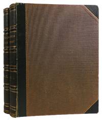
réf. 312601London: James S. Virtue N.D. Hardcover. Both Volumes Very Good or better. Front hinges starting on both volumes. Small open tears on panel corners and spine crowns and heels of both volumes. Foxing on front and rear panels of both volumes. Shelfwear on spine side edges of both volumes.; 4to 11" - 13" tall. James S. Virtue hardcover
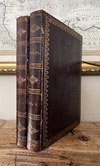
1840réf. B5887London:: George Virtue c. 1840. A near fine and handsome copy bound in decorative original full gilt paneled calf; with text and plates clean and crisp. Edition: First edition. Binding: Contemporary full dark brown gilt and blind paneled calf flat spine in three compartments of Greek gilt-tooled bands and gilt spiral motifs; gilt text on two; endpapers marbled all edges gilt. Notes: William Henry Bartlett was a British artist best known for his numerous steel engravings. In 1835 Bartlett first visited the United States in order to draw the buildings towns and scenery of the northeastern states. The finely detailed steel engravings Bartlett produced were published uncolored with a text by Nathaniel Parker Willis as American Scenery; or Land Lake and River: Illustrations of Transatlantic Nature. American Scenery was published by George Virtue in London in 30 monthly installments from 1837 to 1839. Bound editions of the work were published from 1840 onward. Size: Quarto 267x206mm . Illustration: Illustrated with two 2 illustrated titles with vignettes in colour plus 67 hand-coloured plates in Vol. I and 52 hand-coloured plates in Vol. II for a total of 121 engraved plates overall – these include a frontispiece portrait of Bartlett in black and white signed by him as well as a map of the Northeastern States in contemporary colour outline. Volume: Two Volumes. Provenance: Both volumes have a paste-in ex libris bookplate of ‘Edward Francis Hutton’ on upper pasted endpaper with another much smaller 1’ sticker depicting a sailboat with the initials ‘W.A.H’ beneath; blind seal on verso of lower margin of upper free endpaper ‘ References: Howes B-209; Sabin 3784; Abbey Travel 651. Pages: Vol. I: Frontispiece portrait illustrated title blank title printer’s imprint preface 2 contents 2 bl. map 1-140 with 65 hand-coloured plates; Vol. II: illustrated vignette title blank title printer’s imprint contents 2 1-106 with 52 engraved hand-colour plates. Category: Book Americas U.S.; Book Plate Books Colour; Book Voyages General; George Virtue, unknown
1842réf. 85796hLondon: George Virtue 1842. Book. Near Fine. Hardcover. 4to - over 9¾ - 12" tall. Two volumes bound in early full burgundy leather with decorative gilt to spines and boards. All edges gilt; yellow endpapers. Lacks portrait of Bartlett but includes a portrait of Willis in Volume II. A total of 121 plates including portrait and title-page vignettes all but the map hand-coloured. Inner endpaper hinges cracked but firm and usable. Some slight toning internally but in general bright and clean. Very neat -- a sound and handsome set. iv128pl.;iv116pl.pp. George Virtue Hardcover
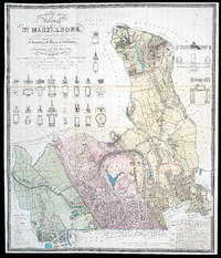
1834réf. 11437London: J. Britton Burton Str. J. Taylor 30 Upper Gower Str. & B.R. Davies 16 George Str. Euston Squ. 1834. 1145 by 950mm 45 by 37.5 inches. Maps""Topographical Survey of the Borough of St. Marylebone Rare large-scale plan of Marylebone Folding engraved map with contemporary hand-colour in full dissected and mounted on linen. The plan depicts the parliamentary constituency of Marylebone which was brought into existence by the Great Reform Act of 1832; the constituency would last until 1885 when it was then split into eight new divisions. Marylebone returned two members to Parliament in 1832: the Liberals Viscount Portman - to whom the plan is dedicated among others - and Sir William Horne. The commissioners had recommended that the part of St Pancras parishes north of the Regent's Canal should not form part of the constituency and should remain in the parliamentary county of Middlesex as this was still a largely rural area - as can be seen upon the present plan. However the inhabitants of St. Pancras petitioned parliament for the inclusion of the entire parish and this was accepted. The plan is replete with information obtained by the commissioners involved in drawing up the new parliamentary constituencies. Below right is a key detailing the parishes Paddington coloured green Marylebone red and St Pancras yellow borough boundaries are marked by a yellow line and estate boundaries with red; a table of parish statistics including number of inhabited and uninhabited houses male and female population age and number of male and female servants property valuations comparative populations from 1801 to 1831 and numbers who voted in the 1832 election. Finally there is a table of churches chapels and municipal buildings detailing their cost and dates of foundation. To the lower left is a table of principal estates with the three parishes. Above the plan are 15 elevations and plans of churches chapels and municipal buildings; these include among others Euston Station All Souls Church Langham Place University College London the Foundling Hospital the Diorama and the Colosseum. The inclusion of these elevations and plans was the work of John Britton 1771-1857 who over saw the production of the plan and was a leading antiquarian and architectural historian. Scale of 9 1/2 to 1 statute mile. BL 10.c.3 J. Britton, Burton Str., J. Taylor, 30 Upper Gower Str., & B.R. Davies, 16 George Str. Euston Squ.,