Farmer, Karen Congo; Fredin, AmyBiblio.com
Cost Accounting: With Integrated Data Analytics
rif. 44191059like new. unknown

GreatBookPrices · Stati Uniti207,71 USD≈ 185,21 €
92 risultati
rif. 19807Temple London . 21 May 1867. 2pp. 12mo. With mourning border. In good condition lightly aged. When Twiss 'suggested the circumstance' Sir R. Palmer 'had some doubts about the United States Courts having limited the criminal consequences of violating neutrality to the cruise last word underlined'. There was also 'some doubt about the effect of a sale by a <> of a Prize Court to a third party. Twiss thinks 'it might be desirable to print & circulate the enclosed observations bearing upon those two points'. Temple [ London ]. 21 May 1867. unknown
1899rif. 91742London: Her Majesty's Stationery Office 1899. Presumed First Edition First Printing. Wraps. Good. 9 1 pages and 36 pages. Tabular Data. This item has been disbound from a larger volume and now has a stiff blue cover protecting it. The British Central Africa Protectorate BCA was a British protectorate proclaimed in 1889 and ratified in 1891 that occupied the same area as present-day Malawi: it was renamed Nyasaland in 1907. British interest in the area arose from visits made by David Livingstone from 1858 onward during his exploration of the Zambezi area. This encouraged missionary activity that started in the 1860s undertaken by the Universities' Mission to Central Africa the Church of Scotland and the Free Church of Scotland and which was followed by a small number of settlers. The Portuguese government attempted to claim much of the area in which the missionaries and settlers operated but this was disputed by the British government. To forestall a Portuguese expedition claiming effective occupation a protectorate was proclaimed first over the south of this area then over the whole of it in 1889. After negotiations with the Portuguese and German governments on its boundaries the protectorate was formally ratified by the British government in May 1891. As late as 1888 the British Foreign Office declined to accept responsibility for protecting the rudimentary British settlements in the Shire Highlands despite unsubstantiated claims by the African Lakes Company of Portuguese interference with their trading activities. However it also declined to negotiate with the Portuguese government on their claim that the Shire Highlands should be considered part of Portuguese East Africa as it was not regarded by the Foreign Office as under effective Portuguese occupation. In order to prevent Portuguese occupation the British government sent Henry Hamilton Johnston as British consul to Mozambique and the Interior with instructions to report on the extent of Portuguese rule in the Zambezi and Shire valleys and the vicinity and to make conditional treaties with local rulers beyond Portuguese jurisdiction. These conditional treaties of friendship did not amount to the establishment of a British protectorate but prevented those rulers from accepting protection from another state. In response to a Portuguese incursion Johnston's deputy John Buchanan declared a Shire Highlands Protectorate in Johnston's absence despite the contrary Foreign Office instructions. It seems probable that Buchanan's action made without reference to the Foreign Office but following instructions that Johnston had left was to prevent any further advance by the Portuguese rather than to establish British rule in the area. Johnston's proclamation of a further protectorate the Nyasaland Districts Protectorate west of Lake Malawi was also contrary to Foreign Office instructions. However it was endorsed by the Foreign Office in May 1891. This was because the discovery of the Chinde channel in the Zambezi delta which was deep enough to allow sea-going ships to enter the Zambezi which was an international waterway without having to enter Portuguese territory whereas previously such ships had to use the port of Quelimane. There followed an Anglo-Portuguese Crisis in which a British refusal of arbitration was followed by the 1890 British Ultimatum of 11 January 1890. This demanded that the Portuguese give up all claims to territories beyond the Ruo River and west of Lake Malawi. The Portuguese government accepted under duress and ordered their troops in the Shire valley to withdraw to the south bank of the Ruo. This order was received by the commander at Katunga on 8 March 1890 and all Portuguese forces had evacuated Katunga and Chiromo by 12 March. An 1891 Anglo-Portuguese treaty fixed the southern borders of what had been renamed the British Central Africa Protectorate. The treaty also granted Britain a 99-year lease over Chinde a port at one of the Zambezi delta mouths where sea-going ships could transfer goods and passengers to river boats. The northern border of the protectorate was agreed at the Songwe River as part of the Anglo-German Convention in 1890. Its western border with Northern Rhodesia was fixed in 1891 at the drainage divide between Lake Malawi and the Luangwa River by agreement with the British South Africa Company which governed what is today Zambia under Royal Charter until 1924. After this until 1898 troops were used to assist the locally recruited police force to suppress the slave trade. The three main groups resisting British occupation were Yao chiefs in the south of the protectorate and Swahili groups around the center and north of Lake Nyasa both involved in the slave trade and Ngoni people who had formed two aggressively expansionists kingdoms in the west and north. As the northern Ngoni kingdom did not threaten European trading interests as it was far from European-owned estates and as the Scottish mission at Livingstonia was influential within the kingdom Johnston did not use force against it. It accepted British rule in 1904 on condition of retaining its own traditions. Its king was recognized as a paramount chief the only one in the protectorate at that time. Her Majesty's Stationery Office paperback
rif. 44191059like new. unknown
rif. 44191059-nnew. unknown
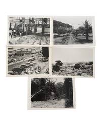
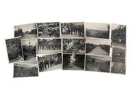
1950rif. 235541950. Belgian Congo colonial photo archive circa 1950s documenting how the Belgian state presented the colony to Western viewers through coffee production planned workers' housing road building urban commerce and managed landscape. Issued through the Belgian Government Information Center in New York the photographs translate colonial rule into a sequence of alluring scenes such as African labor inside an industrial coffee facility a rural workers' village at Bosulo automobiles and commercial buildings in Léopoldville road infrastructure through forest and savannah country in the Kibali Ituri district. The group belongs to the late colonial period when Belgium framed the Congo as a development project while its economy remained structured around extractive agriculture mineral wealth compulsory labor histories and racial hierarchy. Photo archive of five silver gelatin photographs New York: Belgian Government Information Center: Belgium and Belgian Congo each 5 x 7 inches Belgian Congo circa 1950s. The photos show workers handling sacks in a coffee facility; a thatched workers' village with a central road palms and surrounding hills captioned "Workers' village - Bosulo"; a busy Léopoldville commercial district filled with cars pedestrians bicycles storefronts and hotel signage captioned "Commercial center at Leopoldville city life vol. 10"; open savannah in the Kibali Ituri district captioned in handwritten script "In the Kibali Ituri district at a height of about 3000 feet there is a plain covered with savannah. Vegetation and countryside vol. 3"; and a forest road captioned "Vegetatikon and Countryside vol. 3 / Road through the jungle." Belgium ruled the Congo from 1908 after the international scandal of King Leopold II's Congo Free State until Congolese independence in 1960. By the mid twentieth century official Belgian publicity emphasized welfare labor housing roads agriculture and urban modernization recasting colonial control as technical improvement and economic order. These images present coffee production labor housing urban commerce and road construction as evidence of Belgian economic development in the Congo. For native Congolese that industrial system meant wage labor in export agriculture and processing residence in employer or state planned settlements movement through colonial transport networks and participation in an urban economy controlled by Belgian administration and business. Light surface wear and scattered verso stamps and annotations; images remain clean and clear. Overall very good condition. An archive of Congolese labor and land as the basis of late colonial industry in Belgian Congo. unknown
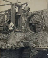
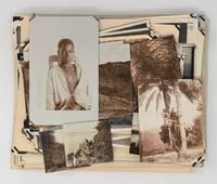
rif. PD4Seventeen unmounted gelatin silver prints including six larger ones ca. 12x17 cm ca. 4 ¾ x 6 ¾ in and seven smaller ones ca. 65x105 cm 2 ½ x 4 ¼ in with three images in between those sizes. The majority with manuscript pencil captions in French on verso. The photographs are sharp and in very good condition. This collection includes early views of Boma – the capital of Belgian Congo – its streets and the house of the “Chef Batailon” and three views of Fort de Shinkakasa built near Boma in 1891 also a panorama of the Congo river with the fort on the right and Boma in the distance. Several views of Lusambo show its streets river and a church under construction. There are also photos of a small village on the Kwamouth river and images of local people shown next to their houses with ox driven carts during the cotton harvest etc. “Boma is a port town on the Congo River some 100 km upstream from the Atlantic Ocean in the Bas-Congo province of the Democratic Republic of the Congo. Boma was the capital city of the Congo Free State and Belgian Congo the modern Democratic Republic of the Congo from 1 May 1886 to 1926 when the capital was moved to Léopoldville since renamed Kinshasa” Wikipedia. “Lusambo is a town and territory in the Sankuru district of the Kasai-Oriental province Democratic Republic of the Congo. The town lies north of the confluence of the Sankuru River and the Lubi River. In 1890 Lusambo was chosen by Paul Le Marinel as the main Belgian base in the Kasai region to defend against the threat of Arab or Swahili traders in slaves and ivory who were encroaching from the east. The station would soon become one of the most important military posts of the Congo Free State with a permanent staff of seventeen whites six hundred native soldiers and four artillery pieces” Wikipedia. unknown
1922rif. 7647Luebo Congo Belge Africa: The J. Leighton Wilson Press American Presbyterian Congo Mission 1922. First Edition. Hardcover. Very good. Plain mauve cloth 5 x 7 inches 58 pp. index clean text. No entries for any edition at WorldCat. We have seen three binding varieties for this issue: blue pebble cloth dark green pebble cloth and a mauve plain cloth.There are 38 articles in the Constitution - these define the work the officers & workers the powers of the officers the election of officers &c. The By-Laws start with no. 39 and run to no. 113. These treat with standing committees and their duties how appointed then practical matters of budgets ordering supplies hospital and medical fees &c. Ends with a 8 pp. index. The J. Leighton Wilson Press | American Presbyterian Congo Mission hardcover
1922rif. 7646Luebo Congo Belge Africa: The J. Leighton Wilson Press American Presbyterian Congo Mission 1922. First Edition. Hardcover. Very good. Dark green pebble cloth 5 x 7 inches a few blotchy stains to the binding 58 pp. index clean text. No entries for any edition at WorldCat. We have seen three binding varieties for this issue: blue pebble cloth dark green pebble cloth and a mauve plain cloth.There are 38 articles in the Constitution - these define the work the officers & workers the powers of the officers the election of officers &c. The By-Laws start with no. 39 and run to no. 113. These treat with standing committees and their duties how appointed then practical matters of budgets ordering supplies hospital and medical fees &c. Ends with a 8 pp. index. The J. Leighton Wilson Press | American Presbyterian Congo Mission hardcover
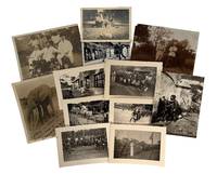
1900rif. 235051900. Belgian colonial Congo photo archive depicting European officials Indigenous Congolese adults and children public ceremony domestic labor and railway grounds between the early twentieth century and 1950. Belgium formally ruled the Congo from 1908 until June 30 1960 after King Leopold II's Congo Free State became notorious for forced labor and violence against Congolese people. A few scenes highlight colonial hierarchy as one photo shows white men in suits helmets and uniforms pose formally in chairs while Congolese men women and children appear as attendants or anthropological subjects surrounding the trio. A 1947 inscription identifying "le régent Charles" places part of the group during the Belgian prince regent's postwar tour of the Congo eight years before King Baudouin visited in 1955 and thirteen years before Congolese independence on June 30 1960. Photo archive of 12 silver gelatin photographs ranging from 3" x 4" to 3.5" x 4.75" Belgian Congo 1900-1950. French inscriptions include "Congo Belge août 1950"; "le régent Charles 1947"; "lundi le 18 janvier 1943 avec notre meilleur bonjour de tous les trois"; and "travailleur portant à l'eau" meaning "worker carrying water." Other scenes show a uniformed colonial procession outside a brick building helmeted men posed in the bush an elephant captioned with French notes Congolese children at a water spout men carrying water a compound walkway a railway yard and Congolese drummers and dancers assembled before mixed local and colonial audiences. The dichotomy of colonists occupying the pose of command travel inspection and ownership while Indigenous Congolese people appear in the surrounding labor ceremony and service spaces make for a compelling collection. Belgian rule in the Congo depended on racial separation administrative paternalism extraction mission education and controlled public ceremony while Congolese political demands intensified after the Second World War and culminated in independence on June 30 1960. Light toning handling and corner wear; photos remain clear and several inscriptions legible en verso; overall in very good condition. This archive gives Belgian colonialism a concrete human scale through officials posed with indigenous children workers ceremonial performers industrial railway spaces and royal reception scenes arranged around the unequal encounter between European power and Indigenous Congolese life. unknown
1911rif. 37502Bruxelles: Publiées par le Ministere des Colonies 1911. First edition. Aqurelles par Norman-H. Hardy. 403 photographs and drawings 2 fold-out maps and 29 full- page folio-size plates containing 20 color drawings 15 color plates of raffia designs 53 photographs of carved figures and objects and 14 photographs of 18th century Bombala embroidery. 1 vols. Large 4to. Original tan printed portfilo. Book loose in fasicules. Fine. wrappers slightly worn. First edition. Aqurelles par Norman-H. Hardy. 403 photographs and drawings 2 fold-out maps and 29 full- page folio-size plates containing 20 color drawings 15 color plates of raffia designs 53 photographs of carved figures and objects and 14 photographs of 18th century Bombala embroidery. 1 vols. Large 4to. Publiées par le Ministere des Colonies unknown
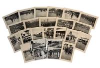
1946rif. 235061946. Congolese ceremonial and colonial encounter photo archive showing indigenous ceremonial dance dress and culture uniformed troops and Belgian officials in the Belgian Congo during the late 1940s and early 1950s. Key scenes are tied to the 1947 visit of Prince Regent Charles to Paulis. Belgium ruled the Congo from 1908 until independence on June 30 1960 after the Belgian parliament took over King Leopold II's Congo Free State following international exposure of forced labor and mass abuses. Several captions appear to place the photographs during the governorship of Eugène Jungers Governor General of the Belgian Congo from December 31 1946 to January 1 1952 a period when Belgian rule promoted "paternal" administration while Congolese political pressure and demands for advancement were growing. The strongest scenes center Congolese public ceremony rather than colonial officials alone: men dancing in lines drummers seated before large instruments children gathered for viewing and performers facing crowds in open fields and palm-lined roads. Chief Tongolo and his daughter appear among colonial representatives during the Prince Regent's visit giving the archive a named Indigenous presence within a public ceremony shaped by Belgian authority. Photo archive of 24 silver gelatin photographs measuring approximately 3" x 4" each Belgian Congo 1940s-1950s. Several French captions can be translated; "Governor General Jungers"; "the regiment's standard at the cemetery"; "parade of the veterans"; and "Congolo gives his speech." Congolese men dance in feathered or fiber headdresses body ornaments patterned waist cloths shields and drums sometimes advancing across open ground before lines of onlookers. Belgian men in white suits and pith helmets stand with Congolese adults and children outside official buildings and in outdoor assembly areas while other scenes show African soldiers in formation a ceremony near railroad tracks a colonial cemetery observance and a station or compound with crowds gathered along walls and platforms. After the Second World War Belgium's Congo policy remained formally paternalist while urbanization war service missionary education and wage labor created new Congolese claims to political recognition that colonial rule could not contain;within thirteen years of Prince Regent Charles's 1947 visit the Congo gained it's independence and became Republic of the Congo. Light handling wear toning and minor curling; captions remain legible on several versos images remain clean and clear. Overall in very good condition. The archive records Congolese ceremonial life at the point where public dance veteran commemoration colonial ceremony military display and Belgian administrative power occupied the same public spaces. unknown
1930rif. 236631930. Mbuti community photo archive depicting Indigenous residents of the Ituri Forest in the Belgian Congo circa 1930s during a period when colonial expansion and missionary work drove foreigners deeper into indigenous communities. Several images concentrate on Mbuti adults and children while photographs of a Western woman and man an automobile and newly accessible routes record the external presence surrounding the encounter. The archive highlights the moment under which Indigenous communities were made visible to Western audiences. Photo archive of 14 silver gelatin photographs each 4" x 6" Ituri Forest Belgian Congo circa 1930s. Several photographs depict large groups of Mbuti men women and children standing in extended lines beside a forest settlement; the adults wear bark cloth patterned wraps or minimal garments and children cluster at the front or beside their mothers. A close portrait centers women and children gathered tightly around an older woman recording individual expressions and family proximity more directly than the formal group arrangements. Other images show dense tropical vegetation cultivated clearings narrow dirt roads rolling grassland and a motorcar traveling through the forest. A Western woman appears alone among tall plants beside a vehicle and on forest paths her repeated placement transforming the landscape into the record of an expedition. The Mbuti comprise several Indigenous forest communities through close relationships with the Ituri environment and neighboring communities. Colonial intervention altered those relationships by imposing territorial administration taxation compulsory labor mission education religious conversion and roads that connected previously remote districts to government and commercial centers. Catholic missions held substantial authority within the Belgian colonial system during the 1920s and 1930s while colonial administrators reorganized settlements and political structures throughout the Ituri region. Minor edge wear and scattered surface marks; images generally retain strong contrast and detail. Overall in good condition. A direct visual record of Mbuti communities confronting the movement of Western people vehicles institutions and cameras into the Ituri Forest under Belgian colonial rule. unknown
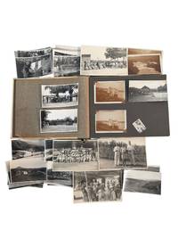
1920rif. 236781920. Belgian Congo colonial residence and indigenous locals photo archive documenting European family life Congolese communities river navigation agricultural districts and travel in the eastern colony circa 1920s to 1930s. The photographs center on Kabalo and related routes through Ituri and Lubero regions integrated into Belgian administration through railways river steamers plantation production and stations built to move personnel and commodities across the interior. European residents appear as travelers hosts sports participants and household members while Congolese people are frequently photographed in large assembled groups at village sites beside transport facilities and within agricultural landscapes shaped by colonial labor demands. Photo album and loose archive of silver gelatin photographs 53 photos with 32 loose most approximately 2.5" x 4" bound in a beige and green board album measuring 7.25" x 10" Belgian Congo circa 1920s to 1930s. Many captioned with name and place identifications. The photographs show European men and women posed in cultivated grounds beside residences on railway platforms and aboard passenger steamers; organized tennis parties and formal gatherings; Congolese crowds assembled beneath palms; workers and families near village buildings; rivers waterfalls upland roads agricultural fields and broad mountain valleys. Several views record launches and larger steam vessels carrying names beginning "Commandant" and "Gouverneur" linking domestic travel to the colonial river fleet. Other images show floodwater submerged or eroded terrain plantation rows administrative or club buildings swimming parties and European visitors observing Congolese gatherings from shaded structures. French inscriptions identify "Kabalo" "Lubero Parc" "Route dans l'Ituri" or "Road in Ituri" and "Petite Halle" or "Small hall." One caption reads in part "L'inondation . de Kabalo mai 1930" or "The flooding . at Kabalo May 1930." Names and surnames visible on versos appear to include Henniger Jordens or Jordaens and possibly Mayenberg; the handwriting does not permit firm identification. Belgian rule after 1908 organized the Congo through concessionary companies missionary institutions administrative posts mines plantations railways and steamer routes intended to extract rubber copper palm products ivory and agricultural commodities while moving European officials and commercial employees through the colony. Kabalo became a strategic junction between the Lualaba River and the rail lines extending toward Lake Tanganyika and the Katanga mining region making it a point where river traffic rail transport labor recruitment and European settlement converged. Minor fading and wear occasional creasing loose photographs and several missing mounts; inscriptions remain generally legible. Overall in good condition. A view at European domestic life in the Belgian Congo depended upon river transport colonial labor agricultural production and the administrative geography of Kabalo and the eastern interior. unknown
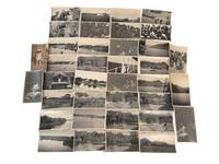
1946rif. 232341946. Belgian Congo photo archive documenting colonialism and segregated settlement in Paulis Jadotville and at Kiubo Falls in 1946-1947 while Belgian rule expanded displacing Congolese communities from political power and control over local resources. Made by an unidentified traveler or colonial observer the group moves between industrial sites river traffic town streets waterfalls village compounds and posed encounters with Congolese residents placing daily life beside the infrastructure of empire. Jadotville in Katanga had been built within the orbit of Union Minière du Haut-Katanga and the copper economy that tied the Congo to European industry; Paulis belonged to the northeastern colonial administrative network that extended surveillance mission activity and commercial penetration into local societies. By the later 1940s these systems were producing wealth for Belgium and foreign markets through forced and controlled labor regimes. Photo archive of 36 black and white silver gelatin photographs various sizes ranging from 2.5" x 3.5" to 5" x 7" Belgian Congo 1946-1947. Nine photographs are identified to the Paulis region in 1946 including versos inscribed in French with "Habitations Européens à Paulis" "Pavillon de l'hotel" and "Le Kigoma sur le fleuve." These images show European-style houses set among palms a large riverside or lakeside steamer a broad colonial street with automobiles and low commercial buildings thatched structures and Congolese figures posed near village compounds and along a tree-lined road. The remaining photographs from Jadotville and Kiubo Falls in 1947 include multiple views of the falls from overlooks and near the waterline several repeated compositions of cascades and riverbanks a dense electrical installation with transformers and steel framing public crowd scenes dugout canoes on calm water groups standing beside temporary camp structures and additional views of thatched settlements large shade trees and Congolese men women and children positioned before houses or in open clearings. Several photographs set European-built environments against Congolese dwellings and occupied landscapes making the colonial dichotomy apparent within this grouping. Waterfalls river steamers electric infrastructure and ordered streets mark the channels through which copper labor and administrative authority moved outward to Belgian and international markets while the photographs of Congolese settlements and residents show the populations who bore that reorganization of land and economy. In the late colonial Congo extraction and transport depended on African labor under coercive conditions and urban growth in places such as Jadotville advanced through racially unequal housing wage structures and civic access leaving Congolese people concentrated in subordinate quarters or rural zones even when their work sustained the entire system. Light wear and occasional creasing; several versos inscribed in French; overall very good condition. An intimate look into Belgian colonial rule at the point where industrial wealth infrastructure and local displacement met on the ground. unknown
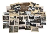
1920rif. 235621920. Belgian Congo travel and colonial encounter photo archive June 1929 documenting Western movement through river settlements Congolese communities and transport corridors during the late 1920s expansion of Belgian colonial administration. The archive dates to the period after Belgium took over the Congo Free State in 1908 and after Leopoldville became the colonial capital in 1926 placing the group inside a decade when river rail missionary commercial and administrative routes shaped how European travelers moved through the colony. The photographs record Congolese people and Western visitors in proximity but the camera's position remains that of the outsider turning encounters village life river crossings and gathered groups into a colonial travel record. Photo archive of 37 likely silver gelatin prints each approximately 3 x 5.5 inches Belgian Congo including Leopoldville June 1929. The photos show broad river views with low shorelines and wooded banks; small boats and steam launches moving across open water; river landings with houses palms and distant hills; rough timber walkways and cleared paths through dense vegetation; and several views of Congolese people near water canoes and village structures. Other images show Western travelers or colonial personnel in light clothing and hats including figures posed near vehicles and on board transport while group scenes show Congolese men women and children gathered in circles or facing the camera. Several photographs depict Congolese men wearing body ornaments patterned cloth arm rings and headdresses including one scene with a large gathered crowd and another showing a man with a leopard skin or spotted pelt before a group. A portrait of a small child standing against a large tree shaded picnic or camp scenes and repeated riverbank views broaden the record from formal encounter to travel rest and observation. One verso is inscribed "Leopoldville. Juin 1929" confirming place and date for at least part of the group. Belgian Congo in 1929 stood between the violent reputation of the Congo Free State and the later high colonial period but Belgian rule continued to depend on racial hierarchy forced labor regimes missionary schooling transport expansion and extractive production. Leopoldville's rise as capital shifted administrative focus inland from Boma and tied the colony more tightly to the Congo River and the Matadi rail connection making the river corridor a principal route for officials commercial travelers missionaries and tourists. These photographs belong to that mobile colonial world: they show Westerners entering Congolese spaces by boat road and landing place while Congolese subjects appear as workers hosts spectators performers children and crowds arranged before an external camera. Light surface wear and toning some versos have penciled inscriptions. Overall in very good condition. A concentrated visual record of Belgian colonial travel and encounter along Congo River routes at the moment Leopoldville was becoming the administrative center of the Belgian Congo. unknown
rif. PF73123 loose gelatin silver photos including 71 large images ca. 175x235 cm 6 ¾ x 9 in one photo ca. 175x205 cm 7x8 in and over forty images from ca. 13x18 cm 5x7 in to ca. 85x13 cm 3 ¼ x 5 in; five small photos are from ca. 8x105 cm 3 ¼ x 4 ¼ in to ca. 55x6 cm 2 x 2 ¼ in; six images are printed as real photo postcards. Three photos with period pencil captions in French on verso; one photo with an ink stamp “Compagnie Aérienne Française 18 Rue de Nanterre Suresnes” on verso. The images were previously removed from an album so most have remnants of mounting on the corners ca. 15 with minor tears or losses to corners. Several images with minor creases on extremities several slightly faded but overall a very good collection. Historically significant extensive collection of original gelatin silver photos showing a copper ore processing plant of the “Compagnie Minière du Congo Français” on the M’Vouvou River near the town of Mindouli French Congo modern-day Pool Department in the middle Congo region of the Republic of Congo. “Compagnie Minière du Congo Français” or CMCF 1911-1962 was established mainly for the extraction of the mineral resources of the Mindouli district reaching the height of its operations in the 1930s after the construction of the ore processing plant on the M’Vouvou River a tributary of the Loukouni which flows into the Niari – the main regional river in 1929. The company was closed shortly after the Republic of Congo gained independence in 1960. The photos include over twenty photos of the M’Vouvou processing plant and the adjacent French residential compound general and close-up views of the plant and the bungalows including six aerial views the factory French compound native villages and roads. Two photos have period pencil captions on verso reading: “Usine de la C.M.C.F. à Mindouli – M’Vouvou;” “Usine de traitement de minerai <…> à Mindouli Vouvou. Proprieté C.M.C.F…” Over seventy photos depict the Loukouni River one image is captioned “Les gorge de la Loukouni” and also most likely its tributaries M’Vouvou and Mindouli which surrounded the area where the plant was constructed. The photos show river valleys and gorges overhanging cliffs rapids and waterfalls with French residents swimming picnicking on the banks posing on a hanging bridge under the cliffs &c. There are also photos of native villages with thatched-roof houses a Congolese town street with an open-air restaurant the interior of a local infirmary with a Congolese caretaker; a biplane sign “O-BAHT” painted on the side with a group of French colonial residents; views of a capsized rail cart on a slope being examined by Congolese workers; portraits of French residents posing next to their bungalows or pretending to do a boxing match Congolese boatsmen and their pirogues workers and their families posing in front of their cottages women working in a field a young man climbing up a palm tree a mother with child and others. Overall an interesting extensive collection of original gelatin silver photos of the Mindouli ore processing plant and district in the middle Congo River in the 1930s. unknown
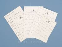
1901rif. 100107AG1901. Laeken / Brussels Château de Laeken Palace of Laeken 1901 - 1906. 16 pages of MLS Manuscript Letters signed on 10 leaves of Leopold's official stationery "Château de Laeken" and "Palais de Bruxelles". The leaves with different sizes 135 cm x 9 cm and 18 cm x 115 cm. Excellent condition. Unsigned. Tremendously rare to find original letters by Leopold II on the open market in which the Colonial Free State and the protection against inquisitive visitors is discussed in such clear and instructive fashion. Leopold's correspondence with Adolphe de Cuvelier shows how he is very much trying to still protect and influence the narrative of his Colonial Slavery Outpost even in the final years of his life. Adolphe de Cuvelier 1860-1931 Secretary General of the Ministry of Foreign Affairs of the Congo Free State President of the Syndicate for Studies and Enterprises in Congo. He was given the title of knight in 1893 and baron in 1908 each transferable at first birth. Wikipedia _______________________________ Leopold II French: Léopold Louis Philippe Marie Victor; 9 April 1835 17 December 1909 was the second King of the Belgians from 1865 to 1909 and through his own efforts the owner and absolute ruler of the Congo Free State from 1885 to 1908. Born in Brussels as the second but eldest surviving son of Leopold I and Louise of Orléans he succeeded his father to the Belgian throne in 1865 and reigned for exactly 44 years until his deaththe longest reign of any Belgian monarch. He died without surviving legitimate sons. The current Belgian king descends from his nephew and successor Albert I. Leopold was the founder and sole owner of the Congo Free State a private project undertaken on his own behalf as a personal union with Belgium. He used Henry Morton Stanley to help him lay claim to the Congo the present-day Democratic Republic of the Congo. At the Berlin Conference of 18841885 the colonial nations of Europe authorized his claim and committed the Congo Free State to him. Leopold ran the Congo using the mercenary Force Publique for his personal gain. He extracted a fortune from the territory initially by the collection of ivory and after a rise in the price of natural rubber in the 1890s by forced labour from the native population to harvest and process rubber. Leopold's administration of the Congo Free State was characterised by atrocities and systematic brutality including torture murder and the amputation of the hands of men women and children when the quota of rubber was not met. In 1890 George Washington Williams used the term "crimes against humanity" to describe the practices of Leopold II of Belgium's administration of the Congo Free State. Colonial accounts typically emphasized Leopold's modernizing changes in the Congo and not the mass death he facilitated. These and other facts were established at the time by eyewitness testimony on-site inspection by an international commission of inquiry and the 1904 Casement Report. Modern estimates range from 1 million to 15 million Congolese deaths with a consensus growing around 10 million. Some historians argue against these figures citing the lack of reliable censuses the enormous mortality caused by smallpox and African trypanosomiasis and the fact that there were only 175 administrative agents in charge of rubber exploitation. In 1908 the reports of deaths and abuse and pressure from the Congo Reform Association and other international groups induced the Belgian government to take over the administration of the Congo from Leopold as a new territory Belgian Congo. Wikipedia unknown