Smith Ch. inc.MareMagnum

1843
ref. ROD0035543Mini guide pour mini Budget. s;d. In-12. Broché. Etat d'usage, Couv. convenable, Dos satisfaisant, Intérieur frais. 158p. + 73p. + 100p;. . . . Classification Dewey : 984-Bolivie
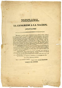
1837ref. 51534Chuquisaca. 1837. Fanning Nationalist Flames in Bolivia in 1837 Nationalist broadside issued by the Bolivian congress in 1837 addressed to the people and exhorting them to have faith in the strength of the government. Published under the dictatorship of Andrès de Santa Cruz at the time of the War of the Confederation which a united Peru and Bolivia fought against Argentina and Chile from 1837 to 1839. OCLC records only one copy at Yale. "¡BOLIVIANOS! Reunidos todos en contorno del Gobierno de un Gobierno enteramente nacional despreciad á vuestros enemigos que emplean contra vosotros la seduccion y el engaño para alucinaros; y entregáos con confianza á las deliberaciones de la Representacion Nacional que no han tenido otro objecto que la Patria el nombre de BOLIVIA el pabellon tricolor su Constitucion y su indepencia que acaban de afianzar para siempre sin menoscabo alguno." Several chips and tears one two-inch tear at lower right edge. Light foxing and tanning. About good. OCLC 54309684. unknown books
1837ref. 51534Chuquisaca. 1837. Fanning Nationalist Flames in Bolivia in 1837 Nationalist broadside issued by the Bolivian congress in 1837 addressed to the people and exhorting them to have faith in the strength of the government. Published under the dictatorship of Andrès de Santa Cruz at the time of the War of the Confederation which a united Peru and Bolivia fought against Argentina and Chile from 1837 to 1839. OCLC records only one copy at Yale. "¡BOLIVIANOS! Reunidos todos en contorno del Gobierno de un Gobierno enteramente nacional despreciad á vuestros enemigos que emplean contra vosotros la seduccion y el engaño para alucinaros; y entregáos con confianza á las deliberaciones de la Representacion Nacional que no han tenido otro objecto que la Patria el nombre de BOLIVIA el pabellon tricolor su Constitucion y su indepencia que acaban de afianzar para siempre sin menoscabo alguno." Several chips and tears one two-inch tear at lower right edge. Light foxing and tanning. About good. OCLC 54309684. unknown
1968bross. edit.
1910ref. 139368Couverture souple. Tiré à part de 58 pages, sur papier glacé.
Small 8vo, 18.5cm. Pp. 427, few photos and drawings, bibl. Orig. wrs.
2008ref. R160198884LES PRAIRIES ORDINAIRES. 2008. In-12. Broché. Bon état, Couv. convenable, Dos satisfaisant, Intérieur frais. 121 pages. . . . Classification Dewey : 984-Bolivie
1969ref. ZB351635La Paz 1969. Price HAS BEEN REDUCED by 10% until Monday Nov. 2 weekend sale item 30 pp. original paper wrappers well illustrated good-very good. - If you are reading this this item is actually physically in our stock and ready for shipment once ordered. We are not bookjackers. Buyer is responsible for any additional duties taxes or fees required by recipient's country. La Paz? unknown
ref. GF7812Gravure sur bois de 26,5 x17,5 cm marges comprises - Avec une notice biographique par Meulemans -
2003ref. Rev8213,5 cm X 21,1 cm, 538 pp, couverture souple illustrée. Broché.
2009Mm 230x280 Volume nella sua brossura originale, 191 pagine profusamente illustrate in nero e a colori lungo l'intero testo. Copia in perfette condizioni di nuovo-new, spedizione in 24 ore dalla conferma dell'ordine.
1824Carta geografica, in coloritura coeva, riguardante il Perù, il Cile, parte della Bolivia, Paraguay, Uruguay e Argentina. Inserita nell'opera "Smith's New General Atlas Containing Distinct Maps Of all the Principal Empires, Kingdoms, & States Throughout the World arranged according to the General Treaty signed in Congress at Vienna June 1815 - London, Printed for C. Smith, Mapseller extraordinary, To His Majesty. N° 172 Strand with additions 1822 to 1824". Edizione non menzionata dal Phillips
1860Carta geografica raffigurante i territori dell'America meridionale relativi a Perù, Bolivia e Cile. Piccoli fori di tarlo che non compromettono l'ottimo stato di conservazione generale. Attraente coloritura coeva all'acquerello.
1856ref. 28032Philadelphia: Charles Desilver 1856. 17¼" X 13 3/4" image 15" X 12½". Hand colored. Decorative border. Very good. 2" tear at upper right corner archivally repaired on verso touches upon one corner of border. Charles Desilver unknown
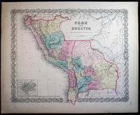
1857ref. 030219New York City NY: J.H. Colton & Co. 1857. Hand-colored map; with decorative border. Separate text sheets with Peru and Bolivia demographic details. Map printed for use in Colton's uncommon Advertising Atlas of America 1857; American companies used the publication of this atlas as an advertising vehicle to promote their businesses. The atlas made use of the same maps used in the 1855 printing with many of them having that imprint date. Richard Swainson Fisher authored the accompanying geographical statistical and historical descriptions. Approx. 15" x 18 1/2" overall size. A little edge-toning to the paper; faint old discoloration at left margin. In good condition. Note: Shipped rolled for safety. . Map. Good. J.H. Colton & Co.
1851ref. 2007AG1851. London & New York J & F. Tallis 1851. Original steel engraving / Vintage map. Drawn and engraved by John Rapkin. Partly hand-coloured. Plate Size: 24.7 cm x 33.8 cm. Sheet Size: 27.4 cm x 37.5 cm. Vintage 19th century map in very good condition. John Tallis 7 November 1817 3 June 1876 was an English cartographic publisher. His company John Tallis and Company published views maps and atlases in London from roughly 1838 to 1851. Tallis set up as a publisher with Frederick Tallis in Cripplegate in 1842; the business moved to Smithfield in 1846 and was dissolved in 1849. From 1851 to 1854 Tallis operated as John Tallis and Company. He started The illustrated news of the world and national portrait gallery of eminent personages in 1858 selling it for £1370 in 1861; it folded in 1863. Wikipedia The most important project John Tallis undertook was the 'Illustrated Atlas' from 1851. The original map we offer here was part of this exceptional Atlas and all the maps it contained are still today considered as the last reminder of an era of lavish map production. Tallis worked the project together with John Rapkin 1815-1876 and it was Rapkin's style and talent that we have to thank for when we marvel at these maps today. What makes these maps so special is the detail of engraved vignettes that surround the map and often show indigenous scenes people in their environment and even more so historical buildings or historical views of towns and cities architecture and landscape. The project of 'The Illustrated Atlas' was designed to be finished just in time for the anxiously awaited "Great Exhibition of the Works of Industry of All Nations" or The Great Exhibition sometimes referred to as the Crystal Palace Exhibition in reference to the temporary structure in which it was held was an international exhibition that took place in Hyde Park London from 1 May to 11 October 1851. It was the first in a series of World's Fairs exhibitions of culture and industry that became popular in the 19th century and it was a much anticipated event. The Great Exhibition was organized by Henry Cole and Prince Albert husband of the reigning monarch Queen Victoria. It was attended by numerous notable figures of the time including Charles Darwin Samuel Colt members of the Orléanist Royal Family and the writers Charlotte Brontë Charles Dickens Lewis Carroll George Eliot and Alfred Tennyson. Music for the opening was under the direction of Sir George Thomas Smart and the continuous music from the exhibited organs for the Queen's procession was "under the superintendence of William Sterndale Bennett". Wikipedia unknown
1880In-8 gr. (mm. 265x183), bellissima legatura edit. figurata in oro e nero, titolo oro al dorso interamente decorato, risg. damascati, tagli dorati, pp. (4),XI,796, magnificamente illustrato nel testo da inc. su legno: sono “plus de 1100 gravures, 27 cartes et 18 plans” di cui 4 a colori, a doppia pagina o più volte ripieg. f.t. (Pérou et Bolivie, itinéraire de Charles Wiener - Plan du Gran Chimu - Plan de Cuzco, première capitale de l’Empire de Tahuantin-Suyu - Vallée de Santa-Ana, depuis le col de la Cordillère orientale jusqu’aux cerros de Ychitariato). “Le 9 juillet 1875, le Ministère de l’instruction publique m’a fait l’honneur de me charger d’une mission archéologique et ethnographique qui s’est terminée le 26 aout 1877”, così precisa nell’introduzione l’A., lo scienziato-esploratore franco austriaco Wiener (1851-1913), forse il più noto per i viaggi effettuati in Perù. La prima parte è dedicata alla descrizione del viaggio, con partenza da Lima; la seconda all’architettura, scultura, oreficeria, ceramica, pittura; la terza si occupa di etnografia, di divinità e culti peruviani, con in fine una sintesi archeologica e storica di queste popolazioni. "Edizione originale". Con aloni e fiorit. ma complessivam. un discreto esemplare.
1837Carta geografica del Perù e della Bolivia. Coloritura coeva ai confini
1843ref. 262561843 Maison Basset, Paris, 1843. hand-coloured map, by George and Smith, BARBIE DU BOCAGE, , image size approximately 22,5 x 30 cm old original print / originale Druckgrafik
ref. 0037Barcelone, Typographie privée de Dionisio Brull, 1898. En espagnol. Édition originale. Grand in-8, 247 x 178 mm. 301 + 4 pp. Reliure artistique éditeur, dessin d'une jeune femme et titre en vert de style Art Nouveau, richement ornementé, le tout rehaussé de dorures. Dos lisse orné en vert et or, nom du livre à la verticale, nom d'auteur à l'horizontale au milieu dans une pièce de titre. Date au dos dans une plaque verte avec encadrement vert et dorure. Minuscule indication "J. Roca Barcelona" au bas de la couverture. Gardes bleutées à motif en croix, cercles et octogones à entrelacs celtiques. Photo de l'auteur en frontispice avec une remarquable dédicace à la plume, à l'écriture élégante, de 1915. Gravures d'inspiration romantique et bandeaux variés à travers l'ouvrage. La dédicace est adressée à Silvino Gurgel do Amaral (1874-1961), diplomate brésilien au long cours qui commença sa carrière à l'ambassade du Brésil à Saint-Pétersbourg, alors capitale de l'Empire russe, avant de représenter son pays dans de nombreuses villes d'Europe et d'Amérique du Sud. La dédicace, datée de 1915, coïncide avec sa période de service à l'ambassade du Brésil à Asunción en Bolivie. Né à Sucre, en Bolivie, Ricardo Mujía (1860-1938) fut avocat, professeur de littérature et d'histoire à Sucre et à Chuquisaca, où il assuma les fonctions de recteur d'université. Acteur enthousiaste de la révolution libérale de 1898, il occupe les postes de secrétaire de la présidence de la République, haut fonctionnaire du ministère de l'Instruction publique, ministre du Gouvernement et des Affaires étrangères. Diplomate, il a été secrétaire de la Légation au Brésil, chargé d'affaires au Pérou et ministre de la Légation bolivienne au Paraguay et en Argentine. Lorsque les libéraux perdent le pouvoir face à la révolution républicaine de 1920, Ricardo Mujía se retire de la vie publique et s'établit définitivement dans sa ville natale, d'où il part en 1927 rejoindre Buenos Aires, à la demande du gouvernement, où il contribue à la négociation de la frontière entre l'Argentine et le Paraguay. Poète de transition entre le romantisme et le mouvement moderniste initié par Rubén Darío, Mujía se distingue surtout par ses poèmes épiques d'inspiration patriotique. En 1925, il obtient le Flor Natural et la Banda del Gay Sabre au concours poétique du premier centenaire de la république pour son poème "La creación de Bolivia", une composition de 324 vers, dans laquelle il chante tout au long des vicissitudes de la république et ses cent ans d’histoire. Penumbras constitue son recueil poétique le plus connu. Il a également écrit divers ouvrages sur les limites de la frontière avec le Paraguay et d'autres ouvrages historiques. ********************************************************************************************************** Large octavo, 247 x 178 mm. 301 + 4 pp. Artistic publisher's binding, drawing of a young woman and title in green in the Art Nouveau style, richly ornamented, all enhanced with gilt. Smooth spine decorated in green and gold, book name vertically, author's name horizontally in the center in a title label. Date on the spine in a green plate with a green and gold frame. Tiny inscription "J. Roca Barcelona" at the bottom of the cover. Blue endpapers with a motif of crosses, circles, and octagons with Celtic interlacing. Photo of the author on the frontispiece with a remarkable dedication in elegant penmanship from 1915. Romantic-inspired engravings and various banners throughout the work. The dedication is addressed to Silvino Gurgel do Amaral (1874-1961), a long-serving Brazilian diplomat who began his career at the Brazilian Embassy in Saint Petersburg, then the capital of the Russian Empire, before representing his country in numerous cities throughout Europe and South America. The dedication, dated 1915, coincides with his period of service at the Brazilian Embassy in Asunción, Bolivia. Born in Sucre, Bolivia, Ricardo Mujía (1860-1938) was a lawyer and professor of literature and history in Sucre and Chuquisaca, where he served as university rector. An enthusiastic participant in the liberal revolution of 1898, he held the positions of Secretary to the Presidency of the Republic, senior official in the Ministry of Public Instruction, and Minister of Government and Foreign Affairs. A diplomat, he served as Secretary of the Legation in Brazil, Chargé d'Affaires in Peru, and Minister of the Bolivian Legation in Paraguay and Argentina. When the Liberals lost power in the Republican Revolution of 1920, Ricardo Mujía withdrew from public life and settled permanently in his hometown. From there, he moved to Buenos Aires in 1927 at the government's request, where he contributed to the negotiation of the border between Argentina and Paraguay. A poet of transition between Romanticism and the Modernist movement initiated by Rubén Darío, Mujía is particularly distinguished by his epic poems of patriotic inspiration. In 1925, he won the Flor Natural and the Banda del Gay Saber awards in the poetry competition for the first centenary of the republic for his poem "La creación de Bolivia", a 324-line composition in which he sings about the turmoils of the republic and its hundred years of history. Penumbras is his best-known collection of poetry. He also wrote various works on the limits of the border with Paraguay and other historical works.
ref. 13975176Paris: Musée d'Art Moderne de la Ville de Paris, 1973 in-8, 66 pages, 27 illustrations. Broché.
19138vo; xiv, 285 pp, frontis, numerous plates, ep maps. original pictorial cloth, gilt, slight edgewear, light spotting on spine, spine ends bit frayed, still a bright copy, elaborate gilt pictorial cover, top edge gilted, good, internally very good. A picture of this book is available upon request by email. Travels from Panama largely to Peru including Lake Titicaca, with a short trip to Bolivia. An attractive and well produced book.
Buenos Aires, Editorial Humanior, 1946. 4to.; 294 pp. Con 69 ilustraciones entre el texto y tres láminas, una de ellas plegada. Encuadernación original en tela estampada.
ref. 0366333720.Ghardcover. Good. Access codes and supplements are not guaranteed with used items. May be an ex-library book. hardcover