[Florida]Biblio.com

2733 resultados
1921ref. 40681Washington D.C.: Published by the United States Coast and Geodetic Survey 1921. Nautical chart printed on heavy paper stock. Colored. A rare coastal survey of Miami. Established by President Thomas Jefferson in 1807 as the Survey of the Coast the U.S. Coast and Geodetic Survey was the United States' first civilian scientific agency. This agency has followed its mission to survey the U.S. coastline create nautical charts of the coast and help increase maritime safety since its founding and has often played fascinating roles in significant chapters of U.S. history. It served in all theaters of the Civil War in the service of the Union Army and Navy pioneered acoustic exploration in the wake of the sinking of the Titanic and during WWI it worked to detect enemy submarines. In addition this agency worked to survey and produce detailed maps and renderings of the U.S. coast. These nautical survey maps commonly referred to as "T-sheets" provide fascinating insights into the history of the United States coastline which has and will continue to shift. These maps are the most important data source for understanding the physical and ecological characteristics of the U.S. shoreline. The present map is a highly detailed and accurate sea chart of the Miami area and an important historical view of a developing Florida. Published by the United States Coast and Geodetic Survey unknown
1921ref. 40681Washington D.C.: Published by the United States Coast and Geodetic Survey 1921. Nautical chart printed on heavy paper stock. Colored. A rare coastal survey of Miami. Established by President Thomas Jefferson in 1807 as the Survey of the Coast the U.S. Coast and Geodetic Survey was the United States' first civilian scientific agency. This agency has followed its mission to survey the U.S. coastline create nautical charts of the coast and help increase maritime safety since its founding and has often played fascinating roles in significant chapters of U.S. history. It served in all theaters of the Civil War in the service of the Union Army and Navy pioneered acoustic exploration in the wake of the sinking of the Titanic and during WWI it worked to detect enemy submarines. In addition this agency worked to survey and produce detailed maps and renderings of the U.S. coast. These nautical survey maps commonly referred to as "T-sheets" provide fascinating insights into the history of the United States coastline which has and will continue to shift. These maps are the most important data source for understanding the physical and ecological characteristics of the U.S. shoreline. The present map is a highly detailed and accurate sea chart of the Miami area and an important historical view of a developing Florida. Published by the United States Coast and Geodetic Survey unknown books
1970ref. 70928Tuscaloosa AL: United Klans of America 1970. Large double-folio partly-printed broadside 22 ½ x 17 ½ inches partly a form completed in large black letter manuscript and signed by Robert Shelton as Imperial Wizard and Lewis Perkins as Imperial Kligrapp nation secretary establishing Klavern 200 Florida in Lake Worth Florida February 10 1976 all enclosed within a wide ornamental red border Klan symbols in corners and at head and with a large red central Klan device showing important Klan dates and phrases two fully robed and masked Klan members on rearing horses at the bottom closing with the word "Honor" beribboned imperial seal affixed. OCLC locates six copies of Klan charters from the 1920s one copy each but apparently does not locate one from the United Klans of America formed in the early 1960s when a number of organizations merged; we haven't found a sales record for a charter from either era but are aware of the sale of a 1920s charter for Belhaven N.C. some years ago. Old fold lines rubbed two inch separation at top; some storage wear and soil a good example. Organized with the merger of several Klan organizations in Tuscaloosa Alabama United Klans of America emerged in the early 1960s with its main leader Robert Shelton quickly rising to become its Imperial Wizard. Over the next two years it became well-known for its opposition to the Civil Rights movement and a number of its members were convicted of heinous crimes; including the lynching of Michael Donald in 1981 by UKA members one of whom confessed to the murder and was sentenced to life in prison. Through the Southern Poverty Law Center Donald's family brought a successful suit against the UKA which was unable to pay the several million dollars awarded; through bankruptcy Donald's mother was awarded the UKA property and sold it the UKA ceasing operations in 1988. United Klans of America unknown
1970ref. 70928Tuscaloosa AL: United Klans of America 1970. Large double-folio partly-printed broadside 22 ½ x 17 ½ inches partly a form completed in large black letter manuscript and signed by Robert Shelton as Imperial Wizard and Lewis Perkins as Imperial Kligrapp nation secretary establishing Klavern 200 Florida in Lake Worth Florida February 10 1976 all enclosed within a wide ornamental red border Klan symbols in corners and at head and with a large red central Klan device showing important Klan dates and phrases two fully robed and masked Klan members on rearing horses at the bottom closing with the word "Honor" beribboned imperial seal affixed. OCLC locates six copies of Klan charters from the 1920s one copy each but apparently does not locate one from the United Klans of America formed in the early 1960s when a number of organizations merged; we haven't found a sales record for a charter from either era but are aware of the sale of a 1920s charter for Belhaven N.C. some years ago. Old fold lines rubbed two inch separation at top; some storage wear and soil a good example. Organized with the merger of several Klan organizations in Tuscaloosa Alabama United Klans of America emerged in the early 1960s with its main leader Robert Shelton quickly rising to become its Imperial Wizard. Over the next two years it became well-known for its opposition to the Civil Rights movement and a number of its members were convicted of heinous crimes; including the lynching of Michael Donald in 1981 by UKA members one of whom confessed to the murder and was sentenced to life in prison. Through the Southern Poverty Law Center Donald's family brought a successful suit against the UKA which was unable to pay the several million dollars awarded; through bankruptcy Donald's mother was awarded the UKA property and sold it the UKA ceasing operations in 1988. United Klans of America unknown books
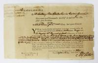
1772ref. 6523West Florida: September 1 1772. About very good. Broadside 7.5 x 12 inches. Lightly tanned old fold lines. Some light chipping at edges slight splitting at some folds. Docketed on verso. A partially-printed form directing Elias Durnford as Surveyor General to survey a tract acquired by William McPherson a British soldier. The parcel in West Florida was to contain "Six hundred acres situate on the River Mississippi adjoining to the southward line of the reserved land near the Natches and between" three other tracts delineated herein. The order is signed by Peter Chester and dated September 1 1772. The docketing on the verso reads "1st September 1772 Warrant of Survey for William Macpherson 600 acres Mississippi." This printed document on watermarked paper is the output of the British press in Pensacola. Peter Chester 1720-1799 was the last British governor of West Florida 1770-1781 and he sought to strengthen British control in the area by offering large land grants to encourage immigration and settlement. Elias Durnford 1739-1794 was a British army officer and civil engineer. He surveyed the town of Pensacola which served as the capitol of British West Florida until the Spanish takeover in 1781. He was also lieutenant governor of West Florida from 1769-1778 and also performed numerous private surveys to supplement his income. A wonderful and early imprint from Pensacola and colonial Florida. September 1 unknown
1772ref. 6523West Florida: September 1 1772. About very good. Broadside 7.5 x 12 inches. Lightly tanned old fold lines. Some light chipping at edges slight splitting at some folds. Docketed on verso. A partially-printed form directing Elias Durnford as Surveyor General to survey a tract acquired by William McPherson a British soldier. The parcel in West Florida was to contain "Six hundred acres situate on the River Mississippi adjoining to the southward line of the reserved land near the Natches and between" three other tracts delineated herein. The order is signed by Peter Chester and dated September 1 1772. The docketing on the verso reads "1st September 1772 Warrant of Survey for William Macpherson 600 acres Mississippi." This printed document on watermarked paper is the output of the British press in Pensacola. Peter Chester 1720-1799 was the last British governor of West Florida 1770-1781 and he sought to strengthen British control in the area by offering large land grants to encourage immigration and settlement. Elias Durnford 1739-1794 was a British army officer and civil engineer. He surveyed the town of Pensacola which served as the capitol of British West Florida until the Spanish takeover in 1781. He was also lieutenant governor of West Florida from 1769-1778 and also performed numerous private surveys to supplement his income. A wonderful and early imprint from Pensacola and colonial Florida. September 1 unknown books
1887ref. 2347741887. 26 leaves with 63 mounted albumen prints most 4-1/2 x 7-7/8 inches all captioned in ink. 1 vols. 4to. Recent red morocco and original red cloth over boards. One photograph with clean split across image no loss. Some fading generally fine and clear. 26 leaves with 63 mounted albumen prints most 4-1/2 x 7-7/8 inches all captioned in ink. 1 vols. 4to. Assembled by a party of men on an extended tour and hunting expedition in the area the album documents numerous locations in southwest Florida in the period immediately following the extension of the Florida Southern Railroad into the Peace River region in 1886. All of the photographs are captioned in ink and all but the first nine which were taken at Interlachen near Gainesville relate to southwest Florida. The album includes scenes of the grounds of Charles Francis Jr. at Interlachen and the residence of Goerge Long; the railway station an office car and a street scene at Trabue; views of the Hotel Punta Gorda under construction; waterfront scenes along the Punta Rassa; views of Fort Myers; a Spanish Fishing village; a "Cracker" family and their orange grove; Judge Ziba King and his house at Fort Ogden; scenes of the Myakka River Bartow and Zolfo Springs and a number of hunting and camping scenes. Nineteenth century photographic albums of Florida are very scarce; the present album shows the rural landscape of southwest Florida at the dawn of the modern age. unknown
1887ref. 2347741887. 26 leaves with 63 mounted albumen prints most 4-1/2 x 7-7/8 inches all captioned in ink. 1 vols. 4to. Recent red morocco and original red cloth over boards. One photograph with clean split across image no loss. Some fading generally fine and clear. 26 leaves with 63 mounted albumen prints most 4-1/2 x 7-7/8 inches all captioned in ink. 1 vols. 4to. Assembled by a party of men on an extended tour and hunting expedition in the area the album documents numerous locations in southwest Florida in the period immediately following the extension of the Florida Southern Railroad into the Peace River region in 1886. All of the photographs are captioned in ink and all but the first nine which were taken at Interlachen near Gainesville relate to southwest Florida. The album includes scenes of the grounds of Charles Francis Jr. at Interlachen and the residence of Goerge Long; the railway station an office car and a street scene at Trabue; views of the Hotel Punta Gorda under construction; waterfront scenes along the Punta Rassa; views of Fort Myers; a Spanish Fishing village; a "Cracker" family and their orange grove; Judge Ziba King and his house at Fort Ogden; scenes of the Myakka River Bartow and Zolfo Springs and a number of hunting and camping scenes. Nineteenth century photographic albums of Florida are very scarce; the present album shows the rural landscape of southwest Florida at the dawn of the modern age. unknown books