CSU of South Florida Staff, Anne BBiblio.com

2852 resultados
ref. 10626-076375630XPaperback. New. Book Condition is in New Paperback Eastern Economy Edition/Indian Edition textbook with identical content as the US version. May have been Printed in India with cover stating Not for sale in US. Fast shipping through the DHL FedEx Aramex And Delivered In 8-12 Days to all worldwide. paperback
ref. 1524972339.Gpaperback. Good. Access codes and supplements are not guaranteed with used items. May be an ex-library book. paperback
1921ref. 40714Washington D.C.: Published by the United States Coast and Geodetic Survey 1921. Large folding nautical sea chart printed on heavy paper stock. Colored. A rare coastal survey of Florida from Jupiter to Miami bisected into two parts including Jupiter West Palm Beach Boca Raton Pompano Beach Fort Lauderdale Hollywood Miami and Key Biscayne. Established by President Thomas Jefferson in 1807 as the Survey of the Coast the U.S. Coast and Geodetic Survey was the United States' first civilian scientific agency. This agency has followed its mission to survey the U.S. coastline create nautical charts of the coast and help increase maritime safety since its founding and has often played fascinating roles in significant chapters of U.S. history. It served in all theaters of the Civil War in the service of the Union Army and Navy pioneered acoustic exploration in the wake of the sinking of the Titanic and during WWI it worked to detect enemy submarines. In addition this agency worked to survey and produce detailed maps and renderings of the U.S. coast. These nautical survey maps commonly referred to as "T-sheets" provide fascinating insights into the history of the United States coastline which has and will continue to shift. These maps are the most important data source for understanding the physical and ecological characteristics of the U.S. shoreline. The present map is a highly detailed and accurate sea chart of the Florida coast from Jupiter to Miami and an important historical view the developing state. Published by the United States Coast and Geodetic Survey unknown
1921ref. 40681Washington D.C.: Published by the United States Coast and Geodetic Survey 1921. Nautical chart printed on heavy paper stock. Colored. A rare coastal survey of Miami. Established by President Thomas Jefferson in 1807 as the Survey of the Coast the U.S. Coast and Geodetic Survey was the United States' first civilian scientific agency. This agency has followed its mission to survey the U.S. coastline create nautical charts of the coast and help increase maritime safety since its founding and has often played fascinating roles in significant chapters of U.S. history. It served in all theaters of the Civil War in the service of the Union Army and Navy pioneered acoustic exploration in the wake of the sinking of the Titanic and during WWI it worked to detect enemy submarines. In addition this agency worked to survey and produce detailed maps and renderings of the U.S. coast. These nautical survey maps commonly referred to as "T-sheets" provide fascinating insights into the history of the United States coastline which has and will continue to shift. These maps are the most important data source for understanding the physical and ecological characteristics of the U.S. shoreline. The present map is a highly detailed and accurate sea chart of the Miami area and an important historical view of a developing Florida. Published by the United States Coast and Geodetic Survey unknown
1921ref. 40707Washington D.C.: Published by the United States Coast and Geodetic Survey 1921. Large folding nautical chart printed on heavy paper stock. Colored. A rare coastal survey of Florida from Jupiter to Miami bisected into two parts including Jupiter West Palm Beach Boca Raton Pompano Beach Fort Lauderdale Hollywood Miami and Key Biscayne. Established by President Thomas Jefferson in 1807 as the Survey of the Coast the U.S. Coast and Geodetic Survey was the United States' first civilian scientific agency. This agency has followed its mission to survey the U.S. coastline create nautical charts of the coast and help increase maritime safety since its founding and has often played fascinating roles in significant chapters of U.S. history. It served in all theaters of the Civil War in the service of the Union Army and Navy pioneered acoustic exploration in the wake of the sinking of the Titanic and during WWI it worked to detect enemy submarines. In addition this agency worked to survey and produce detailed maps and renderings of the U.S. coast. These nautical survey maps commonly referred to as "T-sheets" provide fascinating insights into the history of the United States coastline which has and will continue to shift. These maps are the most important data source for understanding the physical and ecological characteristics of the U.S. shoreline. The present map is a highly detailed and accurate sea chart of the Florida coast from Jupiter to Miami and an important historical view the developing state. Published by the United States Coast and Geodetic Survey unknown
ref. 45148420-nnew. unknown
ref. 44143662-nnew. unknown
ref. 46391556-nnew. unknown
ref. 44086015-nnew. unknown
ref. 45425461-nnew. unknown
ref. 45406992-nnew. unknown
ref. 51790238like new. unknown
ref. 45476696-nnew. unknown
ref. 45224525-nnew. unknown
ref. 1332857116.Gpaperback. Good. Access codes and supplements are not guaranteed with used items. May be an ex-library book. paperback
ref. 0877276099.Gpaperback. Good. Access codes and supplements are not guaranteed with used items. May be an ex-library book. paperback
ref. 1531609465.Ghardcover. Good. Access codes and supplements are not guaranteed with used items. May be an ex-library book. hardcover
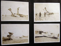
1918ref. 030201Miami Florida: USMC 1918. Over 170 individual images including over 25 larger format 5" x 8" size depicting biplanes seaplanes in flight on the ground in wrecks and being salvaged. Photos pasted-on black album paper pages coming loose from the old post-and-cord binding covers loose and about gone; album approx. 7" x 11" size horizontal format. Photos also include various personnel including a few close-ups and of officers on base and at various duties with occasional views of the town and surrounding areas. Many of the aircraft are training biplanes of the Curtiss Jenny classification with several having their fuselage numbers clearly visible. A few of the photographs are professionally taken by the Miami photography studio of R.B. Hoit with his identifications in the plate. Several dramatic images show grounded and damaged planes and the results of air crashes. At least one of the smaller snapshots show a plane with the fuselage side-marking "Marine Flying Field Miami Florida." A few small 'targeting' photos show aircraft coming into attack range; others show the ground area. Several images give aircraft information "Ng Sea Plane - Curtiss Oxx 6 Motor" HIS - L Flying Boat Liberty Motor." There are also a few photos of blimps. A couple of photos show a downed aircraft in shallow water and being 'salvaged' by personnel floating around attempting to move the plane. Research indicates that "The U. S. Marine Corps leased the old Curtiss Flying Field from Glenn Curtiss. used for training Marine aviators and the first Marine Corps airfield solely used by Marine aircraft. The Marine Flying Field Miami was in operation from March 1918 until September 25 1919 located on the north side of the Miami River at approximately NW 33rd Avenue Miami. The First Marine Aviation Force commanded by Captain Cunningham was formed on April 15 1918 and the four squadrons of this Force designated "A" "B" "C" and "D" rapidly trained for combat flying Curtiss JN-4's and Thomas-Morse Scouts. They were augmented by some 80 Navy pilots who transferred to the Marine Corps in anticipation of a more rapid deployment to the war zone." Information on this USMC base from the Don Boyd pbas website page on this base who also credits Mark Lincoln In addition to the military photographs which are the majority there is a 1911-12 freshman H.S. class photo location unknown; family photographs a few train-schedules pasted-in along with a couple of handwritten notes one by a child; and travel scenery from town and country. A couple of images show a partially-completed Mt. Rushmore South Dakota with George Washington's features the only visible portrait; with other Western America scenery forest & lake vistas mountain ranges; and photographs of folks camping hunting & fishing and the results. A few of the photos edge-and-corner chipped; mostly all in good condition. . Photograph Album. Soft Cover. Good. USMC paperback
ref. 51366565like new. unknown
ref. 45125948like new. unknown
1882ref. 678131882. FLORIDA. Illustrated Florida. Buffalo. 1882. Nineteen chromolithographed views. In original illustrated slipcase. Original retail sticker on back cover small previous owner's label to each side. One chromolithograph creased others in excellent condition. A beautiful series of small chromolithographs of vacationing scenes in northern Florida from the early days of its tourist era. Scenes are in and around Jacksonville along the St. John's River Palatka St. Augustine along the Ocklawaha River and generic southern scenes. The Dodge Company of Buffalo made similar portfolios for other vacation spots. unknown
1961ref. 648221961. CLEMSON Floride. A Rebel Came Home: The Diary of Floride Clemson Tells of Her Wartime Adventures in Yankeeland 1863-64 Her Trip Home to South Carolina and Life in the South during the Last Few Months of the Civil War and the Year Following. Edited by Charles M. McGee Jr. and Ernest M. Lander Jr. Columbia: University of South Carolina Press 1961. 1st ed. xiv153pp. Portrait frontis. illus. portraits maps. orig. cloth non-priceclipped d/j. A very good or better copy. "An interesting and well-edited diary" Nevins II p. 195. . unknown
2024ref. Gyan-9789374565773Facsimile Publisher 2024. Vol. 2nd 1908/1909. Hardcover. New. 25.13 x 18.78 x 3.41 cm. English Facsimile Publisher hardcover
2024ref. Gyan-9789374565773Facsimile Publisher 2024. Vol. 2nd 1908/1909. Hardcover. New. 25.13 x 18.78 x 3.41 cm. English Facsimile Publisher hardcover