VERNE Jules:Livre Rare Book
2139 risultati
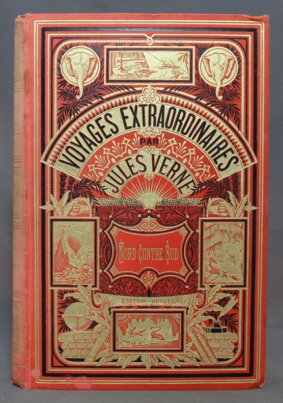
1887rif. 10954Paris, Bibliothèque d'éducation et de récréation - Les Voyages extraordinaires, J. Hetzel et Cie, [1887]. Grand in-8 de [4]-416-7 (catalogue DS) pages, cartonnage rouge d'éditeur "aux deux éléphants" (type 3), second plat de type Lenègre "e" avec macaron central à fond noir. Dos passé, un coin légèrement tapé, 2 petites taches au bord inférieur du premier plat, pâles rousseurs, tampon de possesseur sur garde, faux-titre et page 1.
1959rif. ZB705266Florida Association of Architects / Roger W. Sherman 1959. Volumes 9 through 26 1959-1976 lacking volume 11#11; 12#12; Bound in buckram with original covers included except for the issues for volume 11 & 12 which are unbound in original wrappers. Ex library text clean & bindings tight. - If you are reading this this item is actually physically in our stock and ready for shipment once ordered. We are not bookjackers. Buyer is responsible for any additional duties taxes or fees required by recipient's country. Photos available upon request. Florida Association of Architects / Roger W. Sherman hardcover
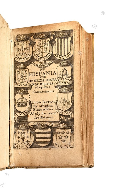
1629rif. 21438Lugd. Batav. (Leyde), ex officina Elzeviriana, 1629 ; in-24 (108 mm), vélin rigide de l’époque, titre manuscrit au dos ; [16], 498 pp., [1] f. de Privilège, titre gravé illustré de blasons.
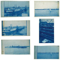
1895rif. 3633601895. Five views of Lake Worth Beach and Palm Beach in 1895. The images are: 1 Ferry at Lake Worth with the Royal Poinciana Hotel in the distance. Captioned in the negative "L.W.B. 9.14.95"; 2 Lake Worth with the Royal Poinciana Hotel in the distance. Captioned in the negative "L.W.B. 9.24.95"; 3 View of Lake Worth with a pier in the foreground possibly taken from a boat. Captioned in the negative "L.W.B. 10.9.95"; 4 Sail boat in front of the Royal Poinciana captioned in the negative "Lake Worth" two versions with different exposure times 5 View of the Palm Beach Inn later renamed The Breakers under construction with the Royal Poinciana in the background not dated but the hotel opened in December 1895. The negatives these views were printed from are of somewhat unusual size measuring roughly 4-3/4 by 7-3/4 inches. All but one view have a horizontal orientation. Given that this size does not seem to conform to the standard halfplate negative usually 5-1/2 to 6-1/2 inches in the long direction one might speculate that the photographer made their own camera. The photographs are handcut with somewhat uneven edges and of varying finished sizes all roughly 5 by 8 inches. They are generally very good or better with some toning and spotting. Uncommon subject matter. unknown
1921rif. 40736Washington D.C.: Published by the United States Coast and Geodetic Survey 1921. Large folding nautical chart printed on heavy paper stock. Colored. A rare original coastal survey of Florida and Alabama from Pensacola Bay showing Perdido Bay including Pensacola Perdido Key and Orange Beach. Established by President Thomas Jefferson in 1807 as the Survey of the Coast the U.S. Coast and Geodetic Survey was the United States' first civilian scientific agency. This agency has followed its mission to survey the U.S. coastline create nautical charts of the coast and help increase maritime safety since its founding and has often played fascinating roles in significant chapters of U.S. history. It served in all theaters of the Civil War in the service of the Union Army and Navy pioneered acoustic exploration in the wake of the sinking of the Titanic and during WWI it worked to detect enemy submarines. In addition this agency worked to survey and produce detailed maps and renderings of the U.S. coast. These nautical survey maps commonly referred to as "T-sheets" provide fascinating insights into the history of the United States coastline which has and will continue to shift. These maps are the most important data source for understanding the physical and ecological characteristics of the U.S. shoreline. The present map is a highly detailed and accurate sea chart of the coastal border between Florida and Alabama and an important historical view of the developing states. Published by the United States Coast and Geodetic Survey unknown books
1917rif. 40710Washington D.C.: Published by the United States Coast and Geodetic Survey 1917. Folding nautical chart printed on heavy paper stock. Uncolored. A rare original coastal survey of Florida's Cedar Keys area. Established by President Thomas Jefferson in 1807 as the Survey of the Coast the U.S. Coast and Geodetic Survey was the United States' first civilian scientific agency. This agency has followed its mission to survey the U.S. coastline create nautical charts of the coast and help increase maritime safety since its founding and has often played fascinating roles in significant chapters of U.S. history. It served in all theaters of the Civil War in the service of the Union Army and Navy pioneered acoustic exploration in the wake of the sinking of the Titanic and during WWI it worked to detect enemy submarines. In addition this agency worked to survey and produce detailed maps and renderings of the U.S. coast. These nautical survey maps commonly referred to as "T-sheets" provide fascinating insights into the history of the United States coastline which has and will continue to shift. These maps are the most important data source for understanding the physical and ecological characteristics of the U.S. shoreline. The present map is a highly detailed and accurate sea chart of Florida's Cedar Keys and an important historical view of a developing Florida. Published by the United States Coast and Geodetic Survey unknown books
1917rif. 40726Washington D.C.: Published by the United States Coast and Geodetic Survey 1917. Nautical chart printed on heavy paper stock. Uncolored with minor wear. A rare original coastal survey of the Legare Anchorage in Florida's Biscayne Bay with Elliot Key and Sands Key. Established by President Thomas Jefferson in 1807 as the Survey of the Coast the U.S. Coast and Geodetic Survey was the United States' first civilian scientific agency. This agency has followed its mission to survey the U.S. coastline create nautical charts of the coast and help increase maritime safety since its founding and has often played fascinating roles in significant chapters of U.S. history. It served in all theaters of the Civil War in the service of the Union Army and Navy pioneered acoustic exploration in the wake of the sinking of the Titanic and during WWI it worked to detect enemy submarines. In addition this agency worked to survey and produce detailed maps and renderings of the U.S. coast. These nautical survey maps commonly referred to as "T-sheets" provide fascinating insights into the history of the United States coastline which has and will continue to shift. These maps are the most important data source for understanding the physical and ecological characteristics of the U.S. shoreline. The present map is a highly detailed and accurate sea chart of the Biscayne Bay region and an important historical view of a developing Florida. Published by the United States Coast and Geodetic Survey unknown books
1917rif. 40713Washington D.C.: Published by the United States Coast and Geodetic Survey 1917. Large folding nautical chart printed on heavy paper stock. Uncolored. Coastal survey map of Tortugas Harbor and approaches with an inset map in the upper left corner of Fort Jefferson. Established by President Thomas Jefferson in 1807 as the Survey of the Coast the U.S. Coast and Geodetic Survey was the United States' first civilian scientific agency. This agency has followed its mission to survey the U.S. coastline create nautical charts of the coast and help increase maritime safety since its founding and has often played fascinating roles in significant chapters of U.S. history. It served in all theaters of the Civil War in the service of the Union Army and Navy pioneered acoustic exploration in the wake of the sinking of the Titanic and during WWI it worked to detect enemy submarines. In addition this agency worked to survey and produce detailed maps and renderings of the U.S. coast. These nautical survey maps commonly referred to as "T-sheets" provide fascinating insights into the history of the United States coastline which has and will continue to shift. These maps are the most important data source for understanding the physical and ecological characteristics of the U.S. shoreline. The present map is inset with a detailed view of Fort Jefferson on Garden Key. Fort Jefferson was an ambitious civil war era coastal defence site which became the largest brick structure in the US. This map is a highly detailed and accurate sea chart of Tortugas Harbor and an important historical view of a developing Florida. Published by the United States Coast and Geodetic Survey unknown books
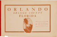
1910rif. 62983St. Augustine: The Record Company ca. 1910. An Early Promotional Booklet for the City Beautiful An early promotional booklet issued by the Orlando Board of Trade encouraging "all newcomers" to "visit this beautiful little city by the lakes." In an effort "to secure tourists winter and permanent residents" the publication touts the city's "superior advantages" "especially in point of situation climate freedom from troublesome insects up-to-date business houses comfortable dwellings good hotels healthfulness paved and shaded streets good schools and churches fine sporting accommodations best drinking water on earth and many other advantages too numerous to mention." The booklet is richly illustrated with halftones from photographs depicting a variety of natural civic and commercial landmarks as well as people engaged in a range of recreational activities. Among other things the illustrations show Orange Avenue the San Juan Hotel people playing golf and lawn tennis a match at the Orlando Polo Club horse-racing and the track of the Orlando Driving Park Association the recently inaugurated Automobile Carnival a newly constructed public school building the Orange County Courthouse various city churches the Rosalind Club House a young woman posing in front of a grapefruit tree and agricultural laborers working in a celery field. Also included are various images of tree-lined streets and the city's many lakes including Lake Sue Lake Minnie Lake Lucerne Lake Eola and Lake Highland. Most of the illustrations were likely taken from photographs by Clarence E. Howard 1858-1930. A native of Pennsylvania Howard first arrived in Orange County Florida in 1883 before settling permanently in Orlando in 1904. There he worked in the publishing business and as a photographer. He edited a number of publications including the Orlando Star the Orange County Reporter the Reporter-Star the Sentinel and later owned and edited the Orange County Citizen. He was active in the civic life of the community serving twelve years as city alderman and as chairman of the District School Trustees. Notably Howard was also for several years secretary of the Orlando Board of Trade the body responsible for producing the present publication. Howard is buried at Orlando's historic Greenwood Cemetery. The date of publication can be roughly surmised from a reference to an "Automobile Carnival" inaugurated a year prior to publication. We find a reference to the Orlando "Automobile Parade" in the Automobile Blue Book from as early as 1912. The present publication must therefore predate that. This copy bears an inkstamp on the titlepage saying that further information could be had from D.S. Shine of Jacksonville. An intriguing and early glimpse of life in Orlando long before it became an international tourist destination. Oblong octavo. Original publisher's red wrappers stapled title in raised gilt letters on front wrapper. Wrappers lightly faded and soiled. Small chip to bottom edge of front wrapper and title leaf not affecting text. Old stamp in purple ink to titlepage see below. Very good. OCLC 882242309. OCLC 1750611. C.E. Howard Early Settlers of Orange County Florida; Reminiscent Historic Biographic Orlando 1915 p.2. The Automobile Blue Book: A Touring Hand-Book of the Most Practicable Routes in Pennsylvania New Jersey and the South Atlantic States New York 1912 p.774. unknown
1910rif. 62983St. Augustine: The Record Company ca. 1910. An Early Promotional Booklet for the City Beautiful An early promotional booklet issued by the Orlando Board of Trade encouraging "all newcomers" to "visit this beautiful little city by the lakes." In an effort "to secure tourists winter and permanent residents" the publication touts the city's "superior advantages" "especially in point of situation climate freedom from troublesome insects up-to-date business houses comfortable dwellings good hotels healthfulness paved and shaded streets good schools and churches fine sporting accommodations best drinking water on earth and many other advantages too numerous to mention." The booklet is richly illustrated with halftones from photographs depicting a variety of natural civic and commercial landmarks as well as people engaged in a range of recreational activities. Among other things the illustrations show Orange Avenue the San Juan Hotel people playing golf and lawn tennis a match at the Orlando Polo Club horse-racing and the track of the Orlando Driving Park Association the recently inaugurated Automobile Carnival a newly constructed public school building the Orange County Courthouse various city churches the Rosalind Club House a young woman posing in front of a grapefruit tree and agricultural laborers working in a celery field. Also included are various images of tree-lined streets and the city's many lakes including Lake Sue Lake Minnie Lake Lucerne Lake Eola and Lake Highland. Most of the illustrations were likely taken from photographs by Clarence E. Howard 1858-1930. A native of Pennsylvania Howard first arrived in Orange County Florida in 1883 before settling permanently in Orlando in 1904. There he worked in the publishing business and as a photographer. He edited a number of publications including the Orlando Star the Orange County Reporter the Reporter-Star the Sentinel and later owned and edited the Orange County Citizen. He was active in the civic life of the community serving twelve years as city alderman and as chairman of the District School Trustees. Notably Howard was also for several years secretary of the Orlando Board of Trade the body responsible for producing the present publication. Howard is buried at Orlando's historic Greenwood Cemetery. The date of publication can be roughly surmised from a reference to an "Automobile Carnival" inaugurated a year prior to publication. We find a reference to the Orlando "Automobile Parade" in the Automobile Blue Book from as early as 1912. The present publication must therefore predate that. This copy bears an inkstamp on the titlepage saying that further information could be had from D.S. Shine of Jacksonville. An intriguing and early glimpse of life in Orlando long before it became an international tourist destination. Oblong octavo. Original publisher's red wrappers stapled title in raised gilt letters on front wrapper. Wrappers lightly faded and soiled. Small chip to bottom edge of front wrapper and title leaf not affecting text. Old stamp in purple ink to titlepage see below. Very good. OCLC 882242309. OCLC 1750611. C.E. Howard Early Settlers of Orange County Florida; Reminiscent Historic Biographic Orlando 1915 p.2. The Automobile Blue Book: A Touring Hand-Book of the Most Practicable Routes in Pennsylvania New Jersey and the South Atlantic States New York 1912 p.774. unknown books
1988rif. ZB394189Florida International University. 1988-1994. volumes 1-2; 6. 1988-1994. partly bound library markings textually clean & tight PRICE IS FOR THE LOT. - If you are reading this this item is actually physically in our stock and ready for shipment once ordered. We are not bookjackers. Buyer is responsible for any additional duties taxes or fees required by recipient's country. Photos available upon request. Florida International University. unknown
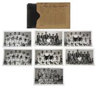
1951rif. 237921951. Largo Florida photograph archive taken by George Fulmer c. 1951 documenting education youth culture housing commerce religion and recreation as a citrus and farming community entered the first phase of its postwar transformation into a suburban city. Largo's population and physical landscape changed rapidly after World War II as groves and grazing land gave way to housing and industrial development; within the wider Pinellas County school system enrollment rose from roughly 16000 students in 1946 to about 69000 in 1962 requiring the construction of 64 new schools between 1948 and 1965. The photographs concentrate unusually closely on the generation educated during this transition recording Largo High School athletics Future Farmers of America Future Homemakers of America youth baseball school music and other organized activities at the moment when the occupational and domestic assumptions of an agricultural community were meeting the demographic and economic conditions of suburban Florida. Photo archive of approximately 87 items including 38 silver gelatin photographs and approximately 38 corresponding large format negatives photograph prints ranging from 4.5 x 2.5 to 5 x 4 inches and each negative about 4 x 5 inches all retained in 11 original numbered photographic job envelopes bearing client subject and occasional date notations Largo Florida principally 1951. The photographs and negatives were made by George Fulmer the longtime Clearwater commercial and civic photographer whose surviving files document decades of local institutional life in central Pinellas County. The original job envelopes preserve Fulmer's assignment structure linking negatives and prints to named Largo clients and subjects rather than leaving the photographs as unidentified local views. The school material includes a large Largo High School Future Homemakers of America group posed beneath the organization's emblem; young women displaying and examining patterned skirts and clothing outdoors; a group identified on its envelope as "Largo High School Boys Girls FFA & FHA"; and children and adolescents posed beneath a sign reading "Largo Chapter Future Farmers of America Department of Vocational Agriculture" some holding hoes shovels and other agricultural implements. Football assignments show night games under field lights players running tackling and breaking through defensive lines referees moving through plays crowded grandstands cheerleaders and a large uniformed marching band packed into the bleachers. Other files document Largo Junior League baseball teams posed with bats gloves coaches and locally lettered uniforms; a Largo Baptist Church choir arranged in the sanctuary; Sinclair gasoline station employees receiving a trophy beside an HC gasoline pump; new residential and commercial buildings; and modern domestic interiors furnished with low upholstered seating lamps paneled walls and contemporary cabinetry. Most negatives duplicate surviving prints. The Largo recorded here was still closely identified with agriculture. Citrus cattle and dairy had dominated the local economy through much of the early twentieth century and Largo had developed into one of Florida's major citrus centers after the arrival of the railroad; within a few years of these photographs freezes in 1957 and 1962 damaged the citrus economy while population growth increased demand for residential and commercial land. Largo High School embodied that transition directly. Its own history recalls an educational culture in which young men studied agriculture tractor repair wood shop and animal science while young women took home economics a gendered vocational division visible here in the paired presence of Future Farmers and Future Homemakers. The Future Homemakers photographs record an educational ideal that treated domestic labor clothing food preparation and household management as formal preparation for female adulthood while the FFA material trained boys for an agricultural economy whose physical basis was already beginning to contract. Largo's accelerating growth soon made the older educational infrastructure inadequate: in 1957 a new Largo High School opened taking 37 acres of land. Postwar industrialization accelerated this transformation as Honeywell and General Electric facilities helped move Largo from an agricultural center toward a suburban economy; housing and trailer parks replaced groves and grazing land and by 1970 the city counted roughly 22300 residents up from 5302 in 1960. The apparently all white school organizations also belong to Pinellas County's segregated educational structure: after the 1954 Brown v. Board of Education decision the county nevertheless built nine additional all Black schools between 1954 and 1963 and only about 200 Black students attended desegregated county schools in 1964. The photographs show some curling but remain in very good condition. Some negatives show fading; original paper job envelopes show handling wear. Overall in very good condition. unknown
1951rif. 237921951. Largo Florida photograph archive taken by George Fulmer c. 1951 documenting education youth culture housing commerce religion and recreation as a citrus and farming community entered the first phase of its postwar transformation into a suburban city. Largo's population and physical landscape changed rapidly after World War II as groves and grazing land gave way to housing and industrial development; within the wider Pinellas County school system enrollment rose from roughly 16000 students in 1946 to about 69000 in 1962 requiring the construction of 64 new schools between 1948 and 1965. The photographs concentrate unusually closely on the generation educated during this transition recording Largo High School athletics Future Farmers of America Future Homemakers of America youth baseball school music and other organized activities at the moment when the occupational and domestic assumptions of an agricultural community were meeting the demographic and economic conditions of suburban Florida. Photo archive of approximately 87 items including 38 silver gelatin photographs and approximately 38 corresponding large format negatives photograph prints ranging from 4.5 x 2.5 to 5 x 4 inches and each negative about 4 x 5 inches all retained in 11 original numbered photographic job envelopes bearing client subject and occasional date notations Largo Florida principally 1951. The photographs and negatives were made by George Fulmer the longtime Clearwater commercial and civic photographer whose surviving files document decades of local institutional life in central Pinellas County. The original job envelopes preserve Fulmer's assignment structure linking negatives and prints to named Largo clients and subjects rather than leaving the photographs as unidentified local views. The school material includes a large Largo High School Future Homemakers of America group posed beneath the organization's emblem; young women displaying and examining patterned skirts and clothing outdoors; a group identified on its envelope as "Largo High School Boys Girls FFA & FHA"; and children and adolescents posed beneath a sign reading "Largo Chapter Future Farmers of America Department of Vocational Agriculture" some holding hoes shovels and other agricultural implements. Football assignments show night games under field lights players running tackling and breaking through defensive lines referees moving through plays crowded grandstands cheerleaders and a large uniformed marching band packed into the bleachers. Other files document Largo Junior League baseball teams posed with bats gloves coaches and locally lettered uniforms; a Largo Baptist Church choir arranged in the sanctuary; Sinclair gasoline station employees receiving a trophy beside an HC gasoline pump; new residential and commercial buildings; and modern domestic interiors furnished with low upholstered seating lamps paneled walls and contemporary cabinetry. Most negatives duplicate surviving prints. The Largo recorded here was still closely identified with agriculture. Citrus cattle and dairy had dominated the local economy through much of the early twentieth century and Largo had developed into one of Florida's major citrus centers after the arrival of the railroad; within a few years of these photographs freezes in 1957 and 1962 damaged the citrus economy while population growth increased demand for residential and commercial land. Largo High School embodied that transition directly. Its own history recalls an educational culture in which young men studied agriculture tractor repair wood shop and animal science while young women took home economics a gendered vocational division visible here in the paired presence of Future Farmers and Future Homemakers. The Future Homemakers photographs record an educational ideal that treated domestic labor clothing food preparation and household management as formal preparation for female adulthood while the FFA material trained boys for an agricultural economy whose physical basis was already beginning to contract. Largo's accelerating growth soon made the older educational infrastructure inadequate: in 1957 a new Largo High School opened taking 37 acres of land. Postwar industrialization accelerated this transformation as Honeywell and General Electric facilities helped move Largo from an agricultural center toward a suburban economy; housing and trailer parks replaced groves and grazing land and by 1970 the city counted roughly 22300 residents up from 5302 in 1960. The apparently all white school organizations also belong to Pinellas County's segregated educational structure: after the 1954 Brown v. Board of Education decision the county nevertheless built nine additional all Black schools between 1954 and 1963 and only about 200 Black students attended desegregated county schools in 1964. The photographs show some curling but remain in very good condition. Some negatives show fading; original paper job envelopes show handling wear. Overall in very good condition. unknown books
1705Raffigurazione geografica del territorio nord americano in particolare di Canada o Nouvelle France ed una parte degli Stati Uniti (Florida, Carolaina, Luisiana, Virginia...). Interessante evidenziare come l'estensione del Canada venga aumentata, verso sud, a discapito dei territori delle colonie inglesi.
1893In-4°, due volumi, (5), CCXLII, 413, due carte pieghevoli (La Florida en el ano 1591, La Florida en el ano 1765), tavole; pp 801 Rilegatura in mezza pergamena con tasselli al dorso. Pedro Menendez de Aviles fu il primo governatore spagnolo della Florida, capo generale dell’Armada contro l’Inghilterra In-4°, two volumes, (5), CCXLII, 413, two folded maps (La Florida en el ano 1591, La Florida en el ano 1765), plates, pp 801. Half parchemine binding. Pedro Menendez de Aviles was the first Spanish governor of Florida, Chief General of the Armada against England
196188 pages. Features: Fantastic fold-out two-panel colour cover photo of the four Richardsons of Regina who are world curling champions; Brief article on how Nanaimo Realty paid its realtors to lose weight - and sales increased!; Nice one-page black and white Volkswagen photo ad entitled "Who backs up the Volkswagen?"; Nice one-page colour photo ad for Florida orange juice shows smiling girl wearing white ear muffs; What Winter Does to Canada - and vice versa; What to wear to a Fashion Opening - photo-illustrated article; Duel in the Kitchen (fiction); The Return of the Winter Carnivals; The Simple Joys of Camping in a Snowdrift; Hockey Isn't As Rough as it Used to Be - Part 1 of Jack Adams' "My 43 Years in Hockey" - photo-illustrated article (with large photo of Howie Meeker pounding a limp Canadien); The Second Splendid Discovery of Spices; How to Gain Entree to the Social Pages; Canada's world champions of Curling - Ernie Richardson and the Richardsons of Regina; Population Explosion on the Ski Slopes; Skier's Dream - two-page colour-photo-illustrated brief article with two maps describe how Franz Wilhelmsen and the Garibaldi Olympic Committee seek to have the massive potential of Whistler Mountain developed for the Winter Olympics of 1968; Best and Worst Movies of 1960; Escape to the Sun - Robert Thomas Allen's road trip from California to Florida; Seagrams ad features colour painting of winter carnival by Henry Simpkins; Large colour ad for Apollo Beach waterfront real estate development near Tampa; Canadian Club colour-photo one-page ad features Walter Gonnason falling into an ice crevasse on Mount Victoria Glacier in Alberta; Why color TV isn't here yet - and when it may be; Colour-photo Coke ad on back cover features skating couple; and more. Discrete six-inch clear archival tape repair to bottom left corner of front cover, otherwise unmmarked with average wear. A quality copy of this great vintage issue. Magazine
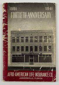
1941rif. 12634N.p. likely Jacksonville Fl. 1941. 4612pp. Original pictorial wrappers stapled. Substantial creasing rubbing dust-soiling and overall wear to wrappers. Faint foxing and spotting to initial and terminal leaves but mostly clean internally. Very good. A rare pamphlet celebrating the fortieth anniversary of the Afro-American Life Insurance Company an important African-American-owned-and-operated insurance company in Florida. The work includes reproductions of congratulatory letters to the company from Florida governor Spessard Holland and others portraits and information on the company’s founders passages on the history of the company information on the successes of the company’s current operations and more. The work is interspersed throughout with a legion of photographs showing the company at work scenes from various branch offices the company’s Funeral Services Division and so forth. "Florida's First African-American Insurance Company -1901-2001. The Afro-American Insurance Company formerly the Afro-American Industrial and Benefits Association was founded in 1901 to provide affordable health insurance and death benefits to the state's African-Americans. Founded by the Reverend E.J. Gregg E.W. Latson Abraham Lincoln Lewis A.W. Price Dr. Arthur W. Smith J.F. Valentine and the Reverend J. Melton Waldron the Afro's first office at 14 Ocean Street was destroyed by the great Jacksonville Fire two months after it opened on May 3 1901. It then moved to 621 Florida Avenue the home of treasurer and future president Abraham Lincoln Lewis 1865-1947. From their next home office at 105 E. Union Street the company wrote millions of dollars of insurance policies and started district offices in Georgia Alabama Louisiana and Texas." - Historical marker at the site of the company's original location in Jacksonville. OCLC reports just two copies at Howard and the University of North Florida. unknown
1941rif. 12634N.p. likely Jacksonville Fl. 1941. 4612pp. Original pictorial wrappers stapled. Substantial creasing rubbing dust-soiling and overall wear to wrappers. Faint foxing and spotting to initial and terminal leaves but mostly clean internally. Very good. A rare pamphlet celebrating the fortieth anniversary of the Afro-American Life Insurance Company an important African-American-owned-and-operated insurance company in Florida. The work includes reproductions of congratulatory letters to the company from Florida governor Spessard Holland and others portraits and information on the company’s founders passages on the history of the company information on the successes of the company’s current operations and more. The work is interspersed throughout with a legion of photographs showing the company at work scenes from various branch offices the company’s Funeral Services Division and so forth. "Florida's First African-American Insurance Company -1901-2001. The Afro-American Insurance Company formerly the Afro-American Industrial and Benefits Association was founded in 1901 to provide affordable health insurance and death benefits to the state's African-Americans. Founded by the Reverend E.J. Gregg E.W. Latson Abraham Lincoln Lewis A.W. Price Dr. Arthur W. Smith J.F. Valentine and the Reverend J. Melton Waldron the Afro's first office at 14 Ocean Street was destroyed by the great Jacksonville Fire two months after it opened on May 3 1901. It then moved to 621 Florida Avenue the home of treasurer and future president Abraham Lincoln Lewis 1865-1947. From their next home office at 105 E. Union Street the company wrote millions of dollars of insurance policies and started district offices in Georgia Alabama Louisiana and Texas." - Historical marker at the site of the company's original location in Jacksonville. OCLC reports just two copies at Howard and the University of North Florida. unknown books
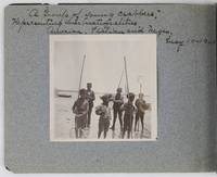
1901rif. 2885Various locations in Florida 1901. About very good. 16 leaves illustrated with thirty-two original vernacular photographs all 3.5 x 3.5 inches most with manuscript captions in ink above the images. Oblong octavo. Contemporary gray paper wrappers white titles on front cover. Spine mostly split a few shallow chips to edges. Internally clean. A small but important vernacular photograph album containing rare views of the devastation wrought by the Great Fire of 1901 in Jacksonville Florida which took place on May 3 1901. The most destructive event in the history of Jacksonville the Great Fire swept through 146 city blocks destroying over 2000 buildings killing seven people and leaving almost 10000 residents without homes. It is considered the third-largest urban fire in United States history after the Great Chicago Fire and the 1906 San Francisco conflagration. The photographs in the present album were taken by an unidentified passenger aboard the Clyde Line steamer Comanche. Eight of the images capture the scene in devastated Jacksonville including a shot of the ruins of the Windsor and St. James hotels shots from atop the "Jacksonville Government Building" a group picture of the city guard "ruins of Jacksonville Court House" "An unknown ruin" a crowded scene at the Jacksonville wharf and a distant shot showing "Ruins of Jacksonville taken from Steamer Comanche May 12." All of the photographs of Jacksonville are dated in manuscript on May 12 1901 nine days after the Great Fire. In addition to the Jacksonville pictures other identified locations along the photographer's voyage include the Hillsborough River near Tampa the Tampa Court House scenes around the Tampa Bay Hotel family pictures in Florida the Comanche and its crew Fort Sumter and four views around Charleston. One particularly notable photograph shows six boys standing in shallow water holding fishing nets likely near Tampa. The image is captioned "A group of young crabbers representing three nationalities American Italian and Negro May 10 1901. unknown
1901rif. 2885Various locations in Florida 1901. About very good. 16 leaves illustrated with thirty-two original vernacular photographs all 3.5 x 3.5 inches most with manuscript captions in ink above the images. Oblong octavo. Contemporary gray paper wrappers white titles on front cover. Spine mostly split a few shallow chips to edges. Internally clean. A small but important vernacular photograph album containing rare views of the devastation wrought by the Great Fire of 1901 in Jacksonville Florida which took place on May 3 1901. The most destructive event in the history of Jacksonville the Great Fire swept through 146 city blocks destroying over 2000 buildings killing seven people and leaving almost 10000 residents without homes. It is considered the third-largest urban fire in United States history after the Great Chicago Fire and the 1906 San Francisco conflagration. The photographs in the present album were taken by an unidentified passenger aboard the Clyde Line steamer Comanche. Eight of the images capture the scene in devastated Jacksonville including a shot of the ruins of the Windsor and St. James hotels shots from atop the "Jacksonville Government Building" a group picture of the city guard "ruins of Jacksonville Court House" "An unknown ruin" a crowded scene at the Jacksonville wharf and a distant shot showing "Ruins of Jacksonville taken from Steamer Comanche May 12." All of the photographs of Jacksonville are dated in manuscript on May 12 1901 nine days after the Great Fire. In addition to the Jacksonville pictures other identified locations along the photographer's voyage include the Hillsborough River near Tampa the Tampa Court House scenes around the Tampa Bay Hotel family pictures in Florida the Comanche and its crew Fort Sumter and four views around Charleston. One particularly notable photograph shows six boys standing in shallow water holding fishing nets likely near Tampa. The image is captioned "A group of young crabbers representing three nationalities American Italian and Negro May 10 1901. unknown books
1917rif. 40711Washington D.C.: Published by the United States Coast and Geodetic Survey 1917. Large folding nautical chart printed on heavy paper stock. Colored. A rare original coastal survey of Charlotte Harbor including Boca Grande and the Charlotte Harbor estuary Florida's second largest estuary and fabled home of mythical pirate Jose Gaspar during Florida's second Spanish period. Established by President Thomas Jefferson in 1807 as the Survey of the Coast the U.S. Coast and Geodetic Survey was the United States' first civilian scientific agency. This agency has followed its mission to survey the U.S. coastline create nautical charts of the coast and help increase maritime safety since its founding and has often played fascinating roles in significant chapters of U.S. history. It served in all theaters of the Civil War in the service of the Union Army and Navy pioneered acoustic exploration in the wake of the sinking of the Titanic and during WWI it worked to detect enemy submarines. In addition this agency worked to survey and produce detailed maps and renderings of the U.S. coast. These nautical survey maps commonly referred to as "T-sheets" provide fascinating insights into the history of the United States coastline which has and will continue to shift. These maps are the most important data source for understanding the physical and ecological characteristics of the U.S. shoreline. The present map is a highly detailed and accurate sea chart of Charlotte Harbor and an important historical view of a developing Florida. Published by the United States Coast and Geodetic Survey unknown books
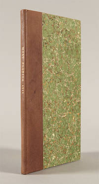
1811rif. 41305Washington City: A. & G. Way 1811. The report of the congressional committee appointed to evaluate the government of Mississippi Territory and the petition of the residents of West Florida what is now the southernmost portions Mississippi and Alabama to be annexed to that territory. The United States had supported the bloodless coup of Americans resident in what was then Spanish territory and annexed the land over Spain's bitter protests. Given the commercial stranglehold New Orleans and Louisiana would have on the region if West Florida were annexed to it thus giving Louisiana almost exclusive access to the Gulf the committee relying heavily on recent census data recommends that Mississippi be admitted to the Union and that West Florida as defined in the 1763 Treaty of Paris be annexed to it. The argument concludes: "The formation of new states on the southern extremity of the United States ought not to be delayed." An important step forward in the development of the Deep South. Scarce. Modern half calf and marbled boards. Lightly foxed. Very good. SHAW & SHOEMAKER 24296. hardcover
1811rif. 41305Washington City: A. & G. Way 1811. The report of the congressional committee appointed to evaluate the government of Mississippi Territory and the petition of the residents of West Florida what is now the southernmost portions Mississippi and Alabama to be annexed to that territory. The United States had supported the bloodless coup of Americans resident in what was then Spanish territory and annexed the land over Spain's bitter protests. Given the commercial stranglehold New Orleans and Louisiana would have on the region if West Florida were annexed to it thus giving Louisiana almost exclusive access to the Gulf the committee relying heavily on recent census data recommends that Mississippi be admitted to the Union and that West Florida as defined in the 1763 Treaty of Paris be annexed to it. The argument concludes: "The formation of new states on the southern extremity of the United States ought not to be delayed." An important step forward in the development of the Deep South. Scarce. Modern half calf and marbled boards. Lightly foxed. Very good. SHAW & SHOEMAKER 24296. hardcover books
2013rif. LB260907011Z61Florida Bar Continuing Legal Education Publication 2013. 7th. paperback. Very Good. 9x6x0. Hardback--corner of first blank page is clipped--otherwise excellent condition--NO DUST COVER Florida Bar Continuing Legal Education Publication paperback
1917rif. 40682Washington D.C.: Published by the United States Coast and Geodetic Survey 1917. Nautical chart printed on heavy paper stock. Colored. A rare coastal survey of the Pensacola area including Destin Fort Walton Santa Rosa Island and Pensacola Beach. Established by President Thomas Jefferson in 1807 as the Survey of the Coast the U.S. Coast and Geodetic Survey was the United States' first civilian scientific agency. This agency has followed its mission to survey the U.S. coastline create nautical charts of the coast and help increase maritime safety since its founding and has often played fascinating roles in significant chapters of U.S. history. It served in all theaters of the Civil War in the service of the Union Army and Navy pioneered acoustic exploration in the wake of the sinking of the Titanic and during WWI it worked to detect enemy submarines. In addition this agency worked to survey and produce detailed maps and renderings of the U.S. coast. These nautical survey maps commonly referred to as "T-sheets" provide fascinating insights into the history of the United States coastline which has and will continue to shift. These maps are the most important data source for understanding the physical and ecological characteristics of the U.S. shoreline. The present map is a highly detailed and accurate sea chart of the Pensacola area and an important historical view of a developing Florida. Published by the United States Coast and Geodetic Survey unknown books