[Florida]ABAA

2 555 résultats
1922réf. 40720Washington D.C.: Published by the United States Coast and Geodetic Survey 1922. Large folding nautical chart printed on heavy paper stock. Colored. A rare original coastal survey of Key West Harbor. Established by President Thomas Jefferson in 1807 as the Survey of the Coast the U.S. Coast and Geodetic Survey was the United States' first civilian scientific agency. This agency has followed its mission to survey the U.S. coastline create nautical charts of the coast and help increase maritime safety since its founding and has often played fascinating roles in significant chapters of U.S. history. It served in all theaters of the Civil War in the service of the Union Army and Navy pioneered acoustic exploration in the wake of the sinking of the Titanic and during WWI it worked to detect enemy submarines. In addition this agency worked to survey and produce detailed maps and renderings of the U.S. coast. These nautical survey maps commonly referred to as "T-sheets" provide fascinating insights into the history of the United States coastline which has and will continue to shift. These maps are the most important data source for understanding the physical and ecological characteristics of the U.S. shoreline. The present map of the Florida coastline is notable in displaying the Overseas Railroad as the only main land transportation link between the Keys. At the time this map was published the overseas highway had yet to be built and tourism and travel in the region was limited to boat or train. This map is a highly detailed and accurate sea chart of Key West and an important historical view of a developing Florida. Published by the United States Coast and Geodetic Survey unknown books
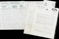
réf. 77874Small packet of marketing materials for the Lakeville Subdivision in North Fort Myers Florida. Housed in a Thomas Realty envelope mailed on April 15 1957 to E.R. Spencer of Delavan Wisconsin the contents include an introductory letter a carbonless purchase contract in triplicate and a detailed plat map 16" x 10". The letter references a booklet which is not present. Located along the Tamiami Trail U.S. 41 north of Fort Myers the Lakeville Subdivision was advertised as a "tropical wonderland" with homesites starting at $250. The plat map corresponds to the second section of the subdivision; presumably the first section had already been sold. However it appears the second section did not attract sufficient investors as this portion of the property remains largely undeveloped. unknown
1917réf. 40726Washington D.C.: Published by the United States Coast and Geodetic Survey 1917. Nautical chart printed on heavy paper stock. Uncolored with minor wear. A rare original coastal survey of the Legare Anchorage in Florida's Biscayne Bay with Elliot Key and Sands Key. Established by President Thomas Jefferson in 1807 as the Survey of the Coast the U.S. Coast and Geodetic Survey was the United States' first civilian scientific agency. This agency has followed its mission to survey the U.S. coastline create nautical charts of the coast and help increase maritime safety since its founding and has often played fascinating roles in significant chapters of U.S. history. It served in all theaters of the Civil War in the service of the Union Army and Navy pioneered acoustic exploration in the wake of the sinking of the Titanic and during WWI it worked to detect enemy submarines. In addition this agency worked to survey and produce detailed maps and renderings of the U.S. coast. These nautical survey maps commonly referred to as "T-sheets" provide fascinating insights into the history of the United States coastline which has and will continue to shift. These maps are the most important data source for understanding the physical and ecological characteristics of the U.S. shoreline. The present map is a highly detailed and accurate sea chart of the Biscayne Bay region and an important historical view of a developing Florida. Published by the United States Coast and Geodetic Survey unknown
1917réf. 40726Washington D.C.: Published by the United States Coast and Geodetic Survey 1917. Nautical chart printed on heavy paper stock. Uncolored with minor wear. A rare original coastal survey of the Legare Anchorage in Florida's Biscayne Bay with Elliot Key and Sands Key. Established by President Thomas Jefferson in 1807 as the Survey of the Coast the U.S. Coast and Geodetic Survey was the United States' first civilian scientific agency. This agency has followed its mission to survey the U.S. coastline create nautical charts of the coast and help increase maritime safety since its founding and has often played fascinating roles in significant chapters of U.S. history. It served in all theaters of the Civil War in the service of the Union Army and Navy pioneered acoustic exploration in the wake of the sinking of the Titanic and during WWI it worked to detect enemy submarines. In addition this agency worked to survey and produce detailed maps and renderings of the U.S. coast. These nautical survey maps commonly referred to as "T-sheets" provide fascinating insights into the history of the United States coastline which has and will continue to shift. These maps are the most important data source for understanding the physical and ecological characteristics of the U.S. shoreline. The present map is a highly detailed and accurate sea chart of the Biscayne Bay region and an important historical view of a developing Florida. Published by the United States Coast and Geodetic Survey unknown books
1917réf. 40688Washington D.C.: Published by the United States Coast and Geodetic Survey 1917. Nautical chart printed on heavy paper stock. Colored. A rare coastal survey of the coast from Tampa to Venice including Sarasota Bradenton Longboat Key and Siesta Key. Established by President Thomas Jefferson in 1807 as the Survey of the Coast the U.S. Coast and Geodetic Survey was the United States' first civilian scientific agency. This agency has followed its mission to survey the U.S. coastline create nautical charts of the coast and help increase maritime safety since its founding and has often played fascinating roles in significant chapters of U.S. history. It served in all theaters of the Civil War in the service of the Union Army and Navy pioneered acoustic exploration in the wake of the sinking of the Titanic and during WWI it worked to detect enemy submarines. In addition this agency worked to survey and produce detailed maps and renderings of the U.S. coast. These nautical survey maps commonly referred to as "T-sheets" provide fascinating insights into the history of the United States coastline which has and will continue to shift. These maps are the most important data source for understanding the physical and ecological characteristics of the U.S. shoreline. The present map is a highly detailed and accurate sea chart of the coast south of Tampa and an important historical view of a developing Florida. Published by the United States Coast and Geodetic Survey unknown
1917réf. 40688Washington D.C.: Published by the United States Coast and Geodetic Survey 1917. Nautical chart printed on heavy paper stock. Colored. A rare coastal survey of the coast from Tampa to Venice including Sarasota Bradenton Longboat Key and Siesta Key. Established by President Thomas Jefferson in 1807 as the Survey of the Coast the U.S. Coast and Geodetic Survey was the United States' first civilian scientific agency. This agency has followed its mission to survey the U.S. coastline create nautical charts of the coast and help increase maritime safety since its founding and has often played fascinating roles in significant chapters of U.S. history. It served in all theaters of the Civil War in the service of the Union Army and Navy pioneered acoustic exploration in the wake of the sinking of the Titanic and during WWI it worked to detect enemy submarines. In addition this agency worked to survey and produce detailed maps and renderings of the U.S. coast. These nautical survey maps commonly referred to as "T-sheets" provide fascinating insights into the history of the United States coastline which has and will continue to shift. These maps are the most important data source for understanding the physical and ecological characteristics of the U.S. shoreline. The present map is a highly detailed and accurate sea chart of the coast south of Tampa and an important historical view of a developing Florida. Published by the United States Coast and Geodetic Survey unknown books
1917réf. 40711Washington D.C.: Published by the United States Coast and Geodetic Survey 1917. Large folding nautical chart printed on heavy paper stock. Colored. A rare original coastal survey of Charlotte Harbor including Boca Grande and the Charlotte Harbor estuary Florida's second largest estuary and fabled home of mythical pirate Jose Gaspar during Florida's second Spanish period. Established by President Thomas Jefferson in 1807 as the Survey of the Coast the U.S. Coast and Geodetic Survey was the United States' first civilian scientific agency. This agency has followed its mission to survey the U.S. coastline create nautical charts of the coast and help increase maritime safety since its founding and has often played fascinating roles in significant chapters of U.S. history. It served in all theaters of the Civil War in the service of the Union Army and Navy pioneered acoustic exploration in the wake of the sinking of the Titanic and during WWI it worked to detect enemy submarines. In addition this agency worked to survey and produce detailed maps and renderings of the U.S. coast. These nautical survey maps commonly referred to as "T-sheets" provide fascinating insights into the history of the United States coastline which has and will continue to shift. These maps are the most important data source for understanding the physical and ecological characteristics of the U.S. shoreline. The present map is a highly detailed and accurate sea chart of Charlotte Harbor and an important historical view of a developing Florida. Published by the United States Coast and Geodetic Survey unknown
1917réf. 40711Washington D.C.: Published by the United States Coast and Geodetic Survey 1917. Large folding nautical chart printed on heavy paper stock. Colored. A rare original coastal survey of Charlotte Harbor including Boca Grande and the Charlotte Harbor estuary Florida's second largest estuary and fabled home of mythical pirate Jose Gaspar during Florida's second Spanish period. Established by President Thomas Jefferson in 1807 as the Survey of the Coast the U.S. Coast and Geodetic Survey was the United States' first civilian scientific agency. This agency has followed its mission to survey the U.S. coastline create nautical charts of the coast and help increase maritime safety since its founding and has often played fascinating roles in significant chapters of U.S. history. It served in all theaters of the Civil War in the service of the Union Army and Navy pioneered acoustic exploration in the wake of the sinking of the Titanic and during WWI it worked to detect enemy submarines. In addition this agency worked to survey and produce detailed maps and renderings of the U.S. coast. These nautical survey maps commonly referred to as "T-sheets" provide fascinating insights into the history of the United States coastline which has and will continue to shift. These maps are the most important data source for understanding the physical and ecological characteristics of the U.S. shoreline. The present map is a highly detailed and accurate sea chart of Charlotte Harbor and an important historical view of a developing Florida. Published by the United States Coast and Geodetic Survey unknown books
1921réf. 40681Washington D.C.: Published by the United States Coast and Geodetic Survey 1921. Nautical chart printed on heavy paper stock. Colored. A rare coastal survey of Miami. Established by President Thomas Jefferson in 1807 as the Survey of the Coast the U.S. Coast and Geodetic Survey was the United States' first civilian scientific agency. This agency has followed its mission to survey the U.S. coastline create nautical charts of the coast and help increase maritime safety since its founding and has often played fascinating roles in significant chapters of U.S. history. It served in all theaters of the Civil War in the service of the Union Army and Navy pioneered acoustic exploration in the wake of the sinking of the Titanic and during WWI it worked to detect enemy submarines. In addition this agency worked to survey and produce detailed maps and renderings of the U.S. coast. These nautical survey maps commonly referred to as "T-sheets" provide fascinating insights into the history of the United States coastline which has and will continue to shift. These maps are the most important data source for understanding the physical and ecological characteristics of the U.S. shoreline. The present map is a highly detailed and accurate sea chart of the Miami area and an important historical view of a developing Florida. Published by the United States Coast and Geodetic Survey unknown
1921réf. 40681Washington D.C.: Published by the United States Coast and Geodetic Survey 1921. Nautical chart printed on heavy paper stock. Colored. A rare coastal survey of Miami. Established by President Thomas Jefferson in 1807 as the Survey of the Coast the U.S. Coast and Geodetic Survey was the United States' first civilian scientific agency. This agency has followed its mission to survey the U.S. coastline create nautical charts of the coast and help increase maritime safety since its founding and has often played fascinating roles in significant chapters of U.S. history. It served in all theaters of the Civil War in the service of the Union Army and Navy pioneered acoustic exploration in the wake of the sinking of the Titanic and during WWI it worked to detect enemy submarines. In addition this agency worked to survey and produce detailed maps and renderings of the U.S. coast. These nautical survey maps commonly referred to as "T-sheets" provide fascinating insights into the history of the United States coastline which has and will continue to shift. These maps are the most important data source for understanding the physical and ecological characteristics of the U.S. shoreline. The present map is a highly detailed and accurate sea chart of the Miami area and an important historical view of a developing Florida. Published by the United States Coast and Geodetic Survey unknown books
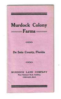
1915réf. 77876Chicago: Murdock Land Company 1915. Informational booklet for the short-lived Murdock Colony Farms on the Arcadia Prairie in South Florida. At the time the property was located in DeSoto County; today it would be situated in Charlotte County on the Gulf side of the Florida peninsula. Includes detailed answers to 111 frequently asked questions and a monthly planting calendar. "The entire tract is divided into 3395 farms and 3395 town lots - and sold a farm and a lot together for $210.00 - payable ten dollars each month. The farms range in size from a 400 acre general farm to a 10 acre fruit farm and truck farm." According to an article in the November 2021 issue of Between the Lines the official newsletter of the Charlotte County Libraries and History "John Milton Murdock's Colony Farms failed after the first rainy season brought extensive flooding that destroyed crops. Attempts to create a canal system to prevent flooding and provide irrigation during the dry season proved unsuccessful and Murdock ultimately fled the area after only a few years." Booklet: 32 pp. including the wrappers 3 1/4" x 6" with a map on the rear panel. Printed on pink paper and bound with two staples. Some very mild toning and wear; otherwise very good. Scarce OCLC locates no holdings. Murdock Land Company unknown
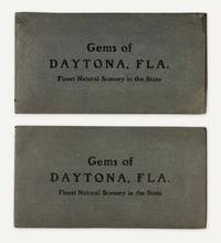
1900réf. ALB.24.0011900. Photo albums 2; Silver prints 15 and photogravures 23. A handsome pair of early-20th century albums with mini-panoramic views of Daytona Florida. There albums contain both silver prints and photogravures. Daytona locations represented in the albums include Daytona Beach; Ormond Drive; the Tomoka River; Ridgewood Avenue; the Claredon Hotel; Seminole Island; the Palmetto Club; Spanish Canal; and more. Most 3 1/4 x 10 inches a few smaller ; With printed captions in negative. unknown
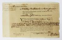
1772réf. 6523West Florida: September 1 1772. About very good. Broadside 7.5 x 12 inches. Lightly tanned old fold lines. Some light chipping at edges slight splitting at some folds. Docketed on verso. A partially-printed form directing Elias Durnford as Surveyor General to survey a tract acquired by William McPherson a British soldier. The parcel in West Florida was to contain "Six hundred acres situate on the River Mississippi adjoining to the southward line of the reserved land near the Natches and between" three other tracts delineated herein. The order is signed by Peter Chester and dated September 1 1772. The docketing on the verso reads "1st September 1772 Warrant of Survey for William Macpherson 600 acres Mississippi." This printed document on watermarked paper is the output of the British press in Pensacola. Peter Chester 1720-1799 was the last British governor of West Florida 1770-1781 and he sought to strengthen British control in the area by offering large land grants to encourage immigration and settlement. Elias Durnford 1739-1794 was a British army officer and civil engineer. He surveyed the town of Pensacola which served as the capitol of British West Florida until the Spanish takeover in 1781. He was also lieutenant governor of West Florida from 1769-1778 and also performed numerous private surveys to supplement his income. A wonderful and early imprint from Pensacola and colonial Florida. September 1 unknown
1772réf. 6523West Florida: September 1 1772. About very good. Broadside 7.5 x 12 inches. Lightly tanned old fold lines. Some light chipping at edges slight splitting at some folds. Docketed on verso. A partially-printed form directing Elias Durnford as Surveyor General to survey a tract acquired by William McPherson a British soldier. The parcel in West Florida was to contain "Six hundred acres situate on the River Mississippi adjoining to the southward line of the reserved land near the Natches and between" three other tracts delineated herein. The order is signed by Peter Chester and dated September 1 1772. The docketing on the verso reads "1st September 1772 Warrant of Survey for William Macpherson 600 acres Mississippi." This printed document on watermarked paper is the output of the British press in Pensacola. Peter Chester 1720-1799 was the last British governor of West Florida 1770-1781 and he sought to strengthen British control in the area by offering large land grants to encourage immigration and settlement. Elias Durnford 1739-1794 was a British army officer and civil engineer. He surveyed the town of Pensacola which served as the capitol of British West Florida until the Spanish takeover in 1781. He was also lieutenant governor of West Florida from 1769-1778 and also performed numerous private surveys to supplement his income. A wonderful and early imprint from Pensacola and colonial Florida. September 1 unknown books
1921réf. 40700Washington D.C.: Published by the United States Coast and Geodetic Survey 1921. Large folding nautical chart printed on heavy paper stock. Colored. A rare coastal survey of Pensacola Bay including Perdido Key Pensacola and Pensacola Beach. Established by President Thomas Jefferson in 1807 as the Survey of the Coast the U.S. Coast and Geodetic Survey was the United States' first civilian scientific agency. This agency has followed its mission to survey the U.S. coastline create nautical charts of the coast and help increase maritime safety since its founding and has often played fascinating roles in significant chapters of U.S. history. It served in all theaters of the Civil War in the service of the Union Army and Navy pioneered acoustic exploration in the wake of the sinking of the Titanic and during WWI it worked to detect enemy submarines. In addition this agency worked to survey and produce detailed maps and renderings of the U.S. coast. These nautical survey maps commonly referred to as "T-sheets" provide fascinating insights into the history of the United States coastline which has and will continue to shift. These maps are the most important data source for understanding the physical and ecological characteristics of the U.S. shoreline. The present map is a highly detailed and accurate sea chart of Pensacola Bay and an important historical view of a developing Florida. Published by the United States Coast and Geodetic Survey unknown
1922réf. 40699Washington D.C.: Published by the United States Coast and Geodetic Survey 1922. Large folding nautical chart printed on heavy paper stock. Colored. A rare coastal survey of Florida and Alabama around Pensacola Bay including Orange Beach Perdido Key Pensacola Pensacola Beach and Santa Rosa Island. Established by President Thomas Jefferson in 1807 as the Survey of the Coast the U.S. Coast and Geodetic Survey was the United States' first civilian scientific agency. This agency has followed its mission to survey the U.S. coastline create nautical charts of the coast and help increase maritime safety since its founding and has often played fascinating roles in significant chapters of U.S. history. It served in all theaters of the Civil War in the service of the Union Army and Navy pioneered acoustic exploration in the wake of the sinking of the Titanic and during WWI it worked to detect enemy submarines. In addition this agency worked to survey and produce detailed maps and renderings of the U.S. coast. These nautical survey maps commonly referred to as "T-sheets" provide fascinating insights into the history of the United States coastline which has and will continue to shift. These maps are the most important data source for understanding the physical and ecological characteristics of the U.S. shoreline. The present map is a highly detailed and accurate sea chart of the Pensacola area and an important historical view of a developing Florida. Published by the United States Coast and Geodetic Survey unknown
1920réf. 40683Washington D.C.: Published by the United States Coast and Geodetic Survey 1920. Nautical chart printed on heavy paper stock. Colored. A rare coastal survey of Pensacola Bay including Pensacola and Santa Rosa Island. Established by President Thomas Jefferson in 1807 as the Survey of the Coast the U.S. Coast and Geodetic Survey was the United States' first civilian scientific agency. This agency has followed its mission to survey the U.S. coastline create nautical charts of the coast and help increase maritime safety since its founding and has often played fascinating roles in significant chapters of U.S. history. It served in all theaters of the Civil War in the service of the Union Army and Navy pioneered acoustic exploration in the wake of the sinking of the Titanic and during WWI it worked to detect enemy submarines. In addition this agency worked to survey and produce detailed maps and renderings of the U.S. coast. These nautical survey maps commonly referred to as "T-sheets" provide fascinating insights into the history of the United States coastline which has and will continue to shift. These maps are the most important data source for understanding the physical and ecological characteristics of the U.S. shoreline. The present map is a highly detailed and accurate sea chart of the Pensacola Bay and an important historical view of a developing Florida. Published by the United States Coast and Geodetic Survey unknown
1921réf. 40700Washington D.C.: Published by the United States Coast and Geodetic Survey 1921. Large folding nautical chart printed on heavy paper stock. Colored. A rare coastal survey of Pensacola Bay including Perdido Key Pensacola and Pensacola Beach. Established by President Thomas Jefferson in 1807 as the Survey of the Coast the U.S. Coast and Geodetic Survey was the United States' first civilian scientific agency. This agency has followed its mission to survey the U.S. coastline create nautical charts of the coast and help increase maritime safety since its founding and has often played fascinating roles in significant chapters of U.S. history. It served in all theaters of the Civil War in the service of the Union Army and Navy pioneered acoustic exploration in the wake of the sinking of the Titanic and during WWI it worked to detect enemy submarines. In addition this agency worked to survey and produce detailed maps and renderings of the U.S. coast. These nautical survey maps commonly referred to as "T-sheets" provide fascinating insights into the history of the United States coastline which has and will continue to shift. These maps are the most important data source for understanding the physical and ecological characteristics of the U.S. shoreline. The present map is a highly detailed and accurate sea chart of Pensacola Bay and an important historical view of a developing Florida. Published by the United States Coast and Geodetic Survey unknown books
1922réf. 40699Washington D.C.: Published by the United States Coast and Geodetic Survey 1922. Large folding nautical chart printed on heavy paper stock. Colored. A rare coastal survey of Florida and Alabama around Pensacola Bay including Orange Beach Perdido Key Pensacola Pensacola Beach and Santa Rosa Island. Established by President Thomas Jefferson in 1807 as the Survey of the Coast the U.S. Coast and Geodetic Survey was the United States' first civilian scientific agency. This agency has followed its mission to survey the U.S. coastline create nautical charts of the coast and help increase maritime safety since its founding and has often played fascinating roles in significant chapters of U.S. history. It served in all theaters of the Civil War in the service of the Union Army and Navy pioneered acoustic exploration in the wake of the sinking of the Titanic and during WWI it worked to detect enemy submarines. In addition this agency worked to survey and produce detailed maps and renderings of the U.S. coast. These nautical survey maps commonly referred to as "T-sheets" provide fascinating insights into the history of the United States coastline which has and will continue to shift. These maps are the most important data source for understanding the physical and ecological characteristics of the U.S. shoreline. The present map is a highly detailed and accurate sea chart of the Pensacola area and an important historical view of a developing Florida. Published by the United States Coast and Geodetic Survey unknown books
1920réf. 40683Washington D.C.: Published by the United States Coast and Geodetic Survey 1920. Nautical chart printed on heavy paper stock. Colored. A rare coastal survey of Pensacola Bay including Pensacola and Santa Rosa Island. Established by President Thomas Jefferson in 1807 as the Survey of the Coast the U.S. Coast and Geodetic Survey was the United States' first civilian scientific agency. This agency has followed its mission to survey the U.S. coastline create nautical charts of the coast and help increase maritime safety since its founding and has often played fascinating roles in significant chapters of U.S. history. It served in all theaters of the Civil War in the service of the Union Army and Navy pioneered acoustic exploration in the wake of the sinking of the Titanic and during WWI it worked to detect enemy submarines. In addition this agency worked to survey and produce detailed maps and renderings of the U.S. coast. These nautical survey maps commonly referred to as "T-sheets" provide fascinating insights into the history of the United States coastline which has and will continue to shift. These maps are the most important data source for understanding the physical and ecological characteristics of the U.S. shoreline. The present map is a highly detailed and accurate sea chart of the Pensacola Bay and an important historical view of a developing Florida. Published by the United States Coast and Geodetic Survey unknown books
1916réf. 40684Washington D.C.: Published by the United States Coast and Geodetic Survey 1916. Nautical chart printed on heavy paper stock. Colored. A rare coastal survey of Florida from Venice Beach to Fort Myers including Cape Coral Boca Grande and Port Charlotte. Established by President Thomas Jefferson in 1807 as the Survey of the Coast the U.S. Coast and Geodetic Survey was the United States' first civilian scientific agency. This agency has followed its mission to survey the U.S. coastline create nautical charts of the coast and help increase maritime safety since its founding and has often played fascinating roles in significant chapters of U.S. history. It served in all theaters of the Civil War in the service of the Union Army and Navy pioneered acoustic exploration in the wake of the sinking of the Titanic and during WWI it worked to detect enemy submarines. In addition this agency worked to survey and produce detailed maps and renderings of the U.S. coast. These nautical survey maps commonly referred to as "T-sheets" provide fascinating insights into the history of the United States coastline which has and will continue to shift. These maps are the most important data source for understanding the physical and ecological characteristics of the U.S. shoreline. The present map is a highly detailed and accurate sea chart of the Fort Myers area and an important historical view of a developing Florida. Published by the United States Coast and Geodetic Survey unknown
1916réf. 40695Washington D.C.: Published by the United States Coast and Geodetic Survey 1916. Large folding nautical chart printed on heavy paper stock. Uncolored. A rare coastal survey of the Fort Myers area including the San Carlos Bay Caloosahatchee River Cape Coral Sanibel Island and Fort Myers Beach. Established by President Thomas Jefferson in 1807 as the Survey of the Coast the U.S. Coast and Geodetic Survey was the United States' first civilian scientific agency. This agency has followed its mission to survey the U.S. coastline create nautical charts of the coast and help increase maritime safety since its founding and has often played fascinating roles in significant chapters of U.S. history. It served in all theaters of the Civil War in the service of the Union Army and Navy pioneered acoustic exploration in the wake of the sinking of the Titanic and during WWI it worked to detect enemy submarines. In addition this agency worked to survey and produce detailed maps and renderings of the U.S. coast. These nautical survey maps commonly referred to as "T-sheets" provide fascinating insights into the history of the United States coastline which has and will continue to shift. These maps are the most important data source for understanding the physical and ecological characteristics of the U.S. shoreline. The present map is a highly detailed and accurate sea chart of Fort Myers area and an important historical view of a developing Florida. Published by the United States Coast and Geodetic Survey unknown
1916réf. 40695Washington D.C.: Published by the United States Coast and Geodetic Survey 1916. Large folding nautical chart printed on heavy paper stock. Uncolored. A rare coastal survey of the Fort Myers area including the San Carlos Bay Caloosahatchee River Cape Coral Sanibel Island and Fort Myers Beach. Established by President Thomas Jefferson in 1807 as the Survey of the Coast the U.S. Coast and Geodetic Survey was the United States' first civilian scientific agency. This agency has followed its mission to survey the U.S. coastline create nautical charts of the coast and help increase maritime safety since its founding and has often played fascinating roles in significant chapters of U.S. history. It served in all theaters of the Civil War in the service of the Union Army and Navy pioneered acoustic exploration in the wake of the sinking of the Titanic and during WWI it worked to detect enemy submarines. In addition this agency worked to survey and produce detailed maps and renderings of the U.S. coast. These nautical survey maps commonly referred to as "T-sheets" provide fascinating insights into the history of the United States coastline which has and will continue to shift. These maps are the most important data source for understanding the physical and ecological characteristics of the U.S. shoreline. The present map is a highly detailed and accurate sea chart of Fort Myers area and an important historical view of a developing Florida. Published by the United States Coast and Geodetic Survey unknown books
1916réf. 40684Washington D.C.: Published by the United States Coast and Geodetic Survey 1916. Nautical chart printed on heavy paper stock. Colored. A rare coastal survey of Florida from Venice Beach to Fort Myers including Cape Coral Boca Grande and Port Charlotte. Established by President Thomas Jefferson in 1807 as the Survey of the Coast the U.S. Coast and Geodetic Survey was the United States' first civilian scientific agency. This agency has followed its mission to survey the U.S. coastline create nautical charts of the coast and help increase maritime safety since its founding and has often played fascinating roles in significant chapters of U.S. history. It served in all theaters of the Civil War in the service of the Union Army and Navy pioneered acoustic exploration in the wake of the sinking of the Titanic and during WWI it worked to detect enemy submarines. In addition this agency worked to survey and produce detailed maps and renderings of the U.S. coast. These nautical survey maps commonly referred to as "T-sheets" provide fascinating insights into the history of the United States coastline which has and will continue to shift. These maps are the most important data source for understanding the physical and ecological characteristics of the U.S. shoreline. The present map is a highly detailed and accurate sea chart of the Fort Myers area and an important historical view of a developing Florida. Published by the United States Coast and Geodetic Survey unknown books
1918réf. 40725Washington D.C.: Published by the United States Coast and Geodetic Survey 1918. Large folding nautical chart printed on heavy paper stock. Colored. A rare original coastal survey of the far Lower Keys region including Marquesas Keys and Boca Grande Key. Established by President Thomas Jefferson in 1807 as the Survey of the Coast the U.S. Coast and Geodetic Survey was the United States' first civilian scientific agency. This agency has followed its mission to survey the U.S. coastline create nautical charts of the coast and help increase maritime safety since its founding and has often played fascinating roles in significant chapters of U.S. history. It served in all theaters of the Civil War in the service of the Union Army and Navy pioneered acoustic exploration in the wake of the sinking of the Titanic and during WWI it worked to detect enemy submarines. In addition this agency worked to survey and produce detailed maps and renderings of the U.S. coast. These nautical survey maps commonly referred to as "T-sheets" provide fascinating insights into the history of the United States coastline which has and will continue to shift. These maps are the most important data source for understanding the physical and ecological characteristics of the U.S. shoreline. The present map is a highly detailed and accurate sea chart of the Lower Keys region and an important historical view of a developing Florida. Published by the United States Coast and Geodetic Survey unknown