Zatta Antonio 1722-1804MareMagnum

2716 risultati
1778Foglio n° XI della grande carta dell'America realizzata in 12 fogli,, coloritura coeva
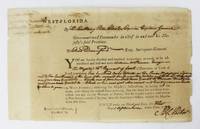
1772rif. 6523West Florida: September 1 1772. About very good. Broadside 7.5 x 12 inches. Lightly tanned old fold lines. Some light chipping at edges slight splitting at some folds. Docketed on verso. A partially-printed form directing Elias Durnford as Surveyor General to survey a tract acquired by William McPherson a British soldier. The parcel in West Florida was to contain "Six hundred acres situate on the River Mississippi adjoining to the southward line of the reserved land near the Natches and between" three other tracts delineated herein. The order is signed by Peter Chester and dated September 1 1772. The docketing on the verso reads "1st September 1772 Warrant of Survey for William Macpherson 600 acres Mississippi." This printed document on watermarked paper is the output of the British press in Pensacola. Peter Chester 1720-1799 was the last British governor of West Florida 1770-1781 and he sought to strengthen British control in the area by offering large land grants to encourage immigration and settlement. Elias Durnford 1739-1794 was a British army officer and civil engineer. He surveyed the town of Pensacola which served as the capitol of British West Florida until the Spanish takeover in 1781. He was also lieutenant governor of West Florida from 1769-1778 and also performed numerous private surveys to supplement his income. A wonderful and early imprint from Pensacola and colonial Florida. September 1 unknown
1772rif. 6523West Florida: September 1 1772. About very good. Broadside 7.5 x 12 inches. Lightly tanned old fold lines. Some light chipping at edges slight splitting at some folds. Docketed on verso. A partially-printed form directing Elias Durnford as Surveyor General to survey a tract acquired by William McPherson a British soldier. The parcel in West Florida was to contain "Six hundred acres situate on the River Mississippi adjoining to the southward line of the reserved land near the Natches and between" three other tracts delineated herein. The order is signed by Peter Chester and dated September 1 1772. The docketing on the verso reads "1st September 1772 Warrant of Survey for William Macpherson 600 acres Mississippi." This printed document on watermarked paper is the output of the British press in Pensacola. Peter Chester 1720-1799 was the last British governor of West Florida 1770-1781 and he sought to strengthen British control in the area by offering large land grants to encourage immigration and settlement. Elias Durnford 1739-1794 was a British army officer and civil engineer. He surveyed the town of Pensacola which served as the capitol of British West Florida until the Spanish takeover in 1781. He was also lieutenant governor of West Florida from 1769-1778 and also performed numerous private surveys to supplement his income. A wonderful and early imprint from Pensacola and colonial Florida. September 1 unknown books
1776Interessante raffigurazione di buona parte orientale degli Stati Uniti. Si trovano raffigurati i territori di New Jersey, Delaware, Maryland, Virginie, Caroline, Georgie, Floride e Louisiane.Il titolo è iscritto in decorativo cartiglio nell'angolo in basso a destra.Coloritura confinale coeva all'acquerello. Alcuni segni del tempo che non compromettono l'ottimale stato di conservazione generale della carta.
rif. 108881Partitions sur les États-Unis
1923rif. 27109Partitions sur l'Amérique du Nord,Partitions sur les États-Unis Salabert 1923
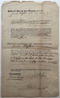
1815rif. 267901New York 1815. unbound. 2 pages front and back 13 x 8 inches signed "Ruggles Hubbard" as Sheriff of New York City -- an arrest warrant for two defendants to appear in Mayors Court September 25 1815 in part: ".I Ruggles Hubbard Sheriff of the City of New York do hereby assign the within written Bail Bond to the use of the plaintiff s to be sued for _____ according to the form of the statute in that case made and provided." Evenly toned with usual folds and a minimum of fraying at the borders; very good condition overall. New York City Sheriff and adventurer who joined his friend General Gregor McGregor's expedition in conquering Spanish Florida June 29 1817 - December 23 1817 culminating in his appointment as Governor of Fernandina. His six-week reign came to an abrupt end after being overthrown by the notorious pirate Luis Aury who claimed Florida in the name of Mexico. unknown
1815rif. 267901New York 1815. unbound. 2 pages front and back 13 x 8 inches signed "Ruggles Hubbard" as Sheriff of New York City -- an arrest warrant for two defendants to appear in Mayors Court September 25 1815 in part: ".I Ruggles Hubbard Sheriff of the City of New York do hereby assign the within written Bail Bond to the use of the plaintiff s to be sued for _____ according to the form of the statute in that case made and provided." Evenly toned with usual folds and a minimum of fraying at the borders; very good condition overall. New York City Sheriff and adventurer who joined his friend General Gregor McGregor's expedition in conquering Spanish Florida June 29 1817 - December 23 1817 culminating in his appointment as Governor of Fernandina. His six-week reign came to an abrupt end after being overthrown by the notorious pirate Luis Aury who claimed Florida in the name of Mexico. unknown books
rif. ria9780323761505_inpPaperback / softback. New. New Book; Fast Shipping from UK; Not signed; Not First Edition; N/A paperback
1929Torino, 1929, 15 settembre, copertina illustrata a colori in fascicolo originale completo di pp. 16 de “Illustrazione del popolo" - Supplemento della ”Gazzetta del Popolo" .
rif. 2471015 March 1830; 6 Royal Circus Edinburgh. See the entries on Tonyn and Paterson in the Oxford DNB the latter stating of the recipient of this letter: ‘On 28 December 1799 he married at St Pancras chapel London Jane Ellen Yeats 1771/2–1846 daughter of David Yeats formerly registrar of East Florida and sister of his first cousin the physician Grant David Yeats.’ Paterson’s mother was a Tonyn and he was also related to the Marchmont family the Earl having been his early patron. The present item is 3pp 4to and a bifolium. It is in fair condition with the customary loss from the breaking of the red wax seal which is present with an impression of a head. The letter has been folded for postage and filing and is minuted: ‘1830 / To Adml Paterson sic relating to Marchmont family’. In pencil presumably by Lady Paterson: ‘To be kept E: J: P.’ Addressed with three postmarks to ‘Mrs. Admiral Paterson / East Cosham / Portsmouth’. Signed ‘Warren H Sands’. The letter begins: ‘Madam / Major General Patrick Tonyn late Governor of East Florida the Revd Charles Tonyn Parson of Radnage John Tonyn Commander of Cavalry in the East India Company Service & Lieut George Home of his Majestys Navy son of the deceased Mr John Home of Abbey St Balhans & sometime minister of the Gospel at Greenlaw & the heirs male of their respective Bodies are called as Heir of Entail in the destination of the Entail of the Estate of Marchmont. It is the intention of Sir W P Hume Campbell the present proprietor of that Estate immediately to Petition Parliament for an Act of Parliament to ffee out the portion of the Estate in and around the Town of Greenlaw for the purpose of extending the Town to obtain this Act of Parliament he requires the consent of the Heirs of Entail in existence.’ As Sands understands Lady Paterson is ‘a near connection of the four heirs of Entail’ he asks if she can confirm that ‘the three first died unmarried & that Mr Home tho’ married left no family’ and who succeeded to any of their property. He is writing to her after having ‘applied to my friend Miss Wauchope of Niddrie on the same subject’. 15 March 1830; 6 Royal Circus, Edinburgh. unknown
1999259 pages. Excellent black and white photographic plates. List of Bure's hockey statistics. List of sources. "...Paints a vivid portrait of Bure that not only captures his electrifying hockey abilities but fills in the blanks of his intriguing personality... This in-depth, unauthorized biography takes us behind the scenes to Bure's origins in his native country and re-creates the fascinating machinations that brought him to the West... Sheds light on the obscure hockey world of the former Soviet Union and delivers what may be the most thorough investigation to date of the impact Russian players have had on the North American game." - from dust jacket. Clean, bright and unmarked with very light wear. An excellent copy of this biography of the most exciting player to ever suit up for the Vancouver Canucks. Book
1921rif. 40700Washington D.C.: Published by the United States Coast and Geodetic Survey 1921. Large folding nautical chart printed on heavy paper stock. Colored. A rare coastal survey of Pensacola Bay including Perdido Key Pensacola and Pensacola Beach. Established by President Thomas Jefferson in 1807 as the Survey of the Coast the U.S. Coast and Geodetic Survey was the United States' first civilian scientific agency. This agency has followed its mission to survey the U.S. coastline create nautical charts of the coast and help increase maritime safety since its founding and has often played fascinating roles in significant chapters of U.S. history. It served in all theaters of the Civil War in the service of the Union Army and Navy pioneered acoustic exploration in the wake of the sinking of the Titanic and during WWI it worked to detect enemy submarines. In addition this agency worked to survey and produce detailed maps and renderings of the U.S. coast. These nautical survey maps commonly referred to as "T-sheets" provide fascinating insights into the history of the United States coastline which has and will continue to shift. These maps are the most important data source for understanding the physical and ecological characteristics of the U.S. shoreline. The present map is a highly detailed and accurate sea chart of Pensacola Bay and an important historical view of a developing Florida. Published by the United States Coast and Geodetic Survey unknown
1922rif. 40699Washington D.C.: Published by the United States Coast and Geodetic Survey 1922. Large folding nautical chart printed on heavy paper stock. Colored. A rare coastal survey of Florida and Alabama around Pensacola Bay including Orange Beach Perdido Key Pensacola Pensacola Beach and Santa Rosa Island. Established by President Thomas Jefferson in 1807 as the Survey of the Coast the U.S. Coast and Geodetic Survey was the United States' first civilian scientific agency. This agency has followed its mission to survey the U.S. coastline create nautical charts of the coast and help increase maritime safety since its founding and has often played fascinating roles in significant chapters of U.S. history. It served in all theaters of the Civil War in the service of the Union Army and Navy pioneered acoustic exploration in the wake of the sinking of the Titanic and during WWI it worked to detect enemy submarines. In addition this agency worked to survey and produce detailed maps and renderings of the U.S. coast. These nautical survey maps commonly referred to as "T-sheets" provide fascinating insights into the history of the United States coastline which has and will continue to shift. These maps are the most important data source for understanding the physical and ecological characteristics of the U.S. shoreline. The present map is a highly detailed and accurate sea chart of the Pensacola area and an important historical view of a developing Florida. Published by the United States Coast and Geodetic Survey unknown
1920rif. 40683Washington D.C.: Published by the United States Coast and Geodetic Survey 1920. Nautical chart printed on heavy paper stock. Colored. A rare coastal survey of Pensacola Bay including Pensacola and Santa Rosa Island. Established by President Thomas Jefferson in 1807 as the Survey of the Coast the U.S. Coast and Geodetic Survey was the United States' first civilian scientific agency. This agency has followed its mission to survey the U.S. coastline create nautical charts of the coast and help increase maritime safety since its founding and has often played fascinating roles in significant chapters of U.S. history. It served in all theaters of the Civil War in the service of the Union Army and Navy pioneered acoustic exploration in the wake of the sinking of the Titanic and during WWI it worked to detect enemy submarines. In addition this agency worked to survey and produce detailed maps and renderings of the U.S. coast. These nautical survey maps commonly referred to as "T-sheets" provide fascinating insights into the history of the United States coastline which has and will continue to shift. These maps are the most important data source for understanding the physical and ecological characteristics of the U.S. shoreline. The present map is a highly detailed and accurate sea chart of the Pensacola Bay and an important historical view of a developing Florida. Published by the United States Coast and Geodetic Survey unknown
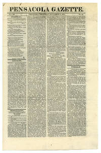
1826rif. 51016Pensacola. Nov. 9 1826. Very Early Florida Newspaper An incredibly early edition of one of the first newspapers in Florida. Founded in 1824 the Pensacola Gazette was issued on a weekly basis for approximately thirty-five years ending in 1861. This four-page issue covers basic interests such as foreign affairs local news and classifieds. Rare. Bifolium. Creases on final page flattened with repair tape. Bright and clean. Very good plus. unknown
1921rif. 40700Washington D.C.: Published by the United States Coast and Geodetic Survey 1921. Large folding nautical chart printed on heavy paper stock. Colored. A rare coastal survey of Pensacola Bay including Perdido Key Pensacola and Pensacola Beach. Established by President Thomas Jefferson in 1807 as the Survey of the Coast the U.S. Coast and Geodetic Survey was the United States' first civilian scientific agency. This agency has followed its mission to survey the U.S. coastline create nautical charts of the coast and help increase maritime safety since its founding and has often played fascinating roles in significant chapters of U.S. history. It served in all theaters of the Civil War in the service of the Union Army and Navy pioneered acoustic exploration in the wake of the sinking of the Titanic and during WWI it worked to detect enemy submarines. In addition this agency worked to survey and produce detailed maps and renderings of the U.S. coast. These nautical survey maps commonly referred to as "T-sheets" provide fascinating insights into the history of the United States coastline which has and will continue to shift. These maps are the most important data source for understanding the physical and ecological characteristics of the U.S. shoreline. The present map is a highly detailed and accurate sea chart of Pensacola Bay and an important historical view of a developing Florida. Published by the United States Coast and Geodetic Survey unknown books
1922rif. 40699Washington D.C.: Published by the United States Coast and Geodetic Survey 1922. Large folding nautical chart printed on heavy paper stock. Colored. A rare coastal survey of Florida and Alabama around Pensacola Bay including Orange Beach Perdido Key Pensacola Pensacola Beach and Santa Rosa Island. Established by President Thomas Jefferson in 1807 as the Survey of the Coast the U.S. Coast and Geodetic Survey was the United States' first civilian scientific agency. This agency has followed its mission to survey the U.S. coastline create nautical charts of the coast and help increase maritime safety since its founding and has often played fascinating roles in significant chapters of U.S. history. It served in all theaters of the Civil War in the service of the Union Army and Navy pioneered acoustic exploration in the wake of the sinking of the Titanic and during WWI it worked to detect enemy submarines. In addition this agency worked to survey and produce detailed maps and renderings of the U.S. coast. These nautical survey maps commonly referred to as "T-sheets" provide fascinating insights into the history of the United States coastline which has and will continue to shift. These maps are the most important data source for understanding the physical and ecological characteristics of the U.S. shoreline. The present map is a highly detailed and accurate sea chart of the Pensacola area and an important historical view of a developing Florida. Published by the United States Coast and Geodetic Survey unknown books
1920rif. 40683Washington D.C.: Published by the United States Coast and Geodetic Survey 1920. Nautical chart printed on heavy paper stock. Colored. A rare coastal survey of Pensacola Bay including Pensacola and Santa Rosa Island. Established by President Thomas Jefferson in 1807 as the Survey of the Coast the U.S. Coast and Geodetic Survey was the United States' first civilian scientific agency. This agency has followed its mission to survey the U.S. coastline create nautical charts of the coast and help increase maritime safety since its founding and has often played fascinating roles in significant chapters of U.S. history. It served in all theaters of the Civil War in the service of the Union Army and Navy pioneered acoustic exploration in the wake of the sinking of the Titanic and during WWI it worked to detect enemy submarines. In addition this agency worked to survey and produce detailed maps and renderings of the U.S. coast. These nautical survey maps commonly referred to as "T-sheets" provide fascinating insights into the history of the United States coastline which has and will continue to shift. These maps are the most important data source for understanding the physical and ecological characteristics of the U.S. shoreline. The present map is a highly detailed and accurate sea chart of the Pensacola Bay and an important historical view of a developing Florida. Published by the United States Coast and Geodetic Survey unknown books
1826rif. 51016Pensacola. Nov. 9 1826. Very Early Florida Newspaper An incredibly early edition of one of the first newspapers in Florida. Founded in 1824 the Pensacola Gazette was issued on a weekly basis for approximately thirty-five years ending in 1861. This four-page issue covers basic interests such as foreign affairs local news and classifieds. Rare. Bifolium. Creases on final page flattened with repair tape. Bright and clean. Very good plus. unknown books
1991True crime story of '.the trusting bride who discoverd her husband was a cold-blooded killer" A matchmaking aunt introduced Lisa Paspalakis, daughter of prosperous Greek American businessman in Daytona Beach, Florida to a "nice" young man from Greece. But instead of the apparrent "perfect husband" Kosta Fotopoulos was a thief, pimp and drug dealer who was eventually convicted of his crimes.248p. + 8 pages of plates. Book
rif. ria9781421413389_inpHardback. New. New Book; Fast Shipping from UK; Not signed; Not First Edition; Scholars and students interested in slavery and abolition British and American politics and culture and Atlantic history will take an interest in this provocative work. hardcover
rif. ria9780471574002_inpHardback. New. New Book; Fast Shipping from UK; Not signed; Not First Edition; As methods for testing and analysing foods become increasingly sophisticated and as laws guarding against toxic food contamination become more and more stringent analytical chemists in environmental agricultural and food laboratorie hardcover
1980rif. Khe01979Frankfurt (S.Fischer) 1980 (= Erste Ausgabe). 8°, Originalbroschur mit Originalumschlag (Paperback ) 401 S., ISBN 3100207084 1
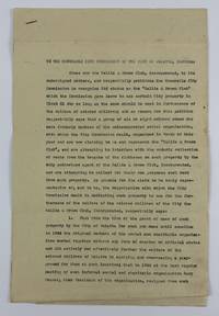
1947rif. 3905Palatka Fl 1947. Very good. 5pp. typed on folio sheets stapled. Old folds minor wear and creasing light dust-soiling. An unsigned petition from the Hallie Q. Brown Club asking "The Honourable City Commission of the City of Palatka Florida.to recognise its status as the 'Hattie Q Brown Club which the Commission gave leave to use certain City property in Block 81.in furtherance of the welfare of colored children." Apparently a splinter group of the club was also claiming to be the Hallie Q. Brown Club and was illegally collecting rents on the groups club house. In asking for official recognition the group details their history of helping African-American youth in the area "by equiping and over-seeing a playground for them." The authors then detail the internal conflicts which occurred amongst the club members the procession of club leadership including several named individuals and the circumstances which led to the club's incorporation ending with the filing of a charter with a Putnam County judge. The fourth section of the club's petition enumerates their activities and plans in "furtherance of the welfare of the colored children of Palatka." The first two points detail the land clearance and construction of the park and their further plans for same; the third point relates to a study the club has undertaken "of the problem of juvenile delinquency among the colored children." Part of their plan is to work with law enforcement "to work out a parole system for first offenders of tender age" as well as "provide a method and place for the incarceration of colored children accused of or guilty of infractions of the law who are less than 12 years of age so that such children may be kept safely in custody and yet not exposed to the bad example and toughening influence of imprisonment in the County jail." Hattie Quinn Brown was a pioneering African-American educator who actively sought the formation of African-American women's clubs throughout the country. unknown