Sherry (University of Florida) AhrentzenBiblio.com

2599 risultati
rif. ria9781447307976_inpHardcover. New. New Book; Fast Shipping from UK; Not signed; Not First Edition; Grounded in an extensive array of research sources this valuable book introduces readers to conditions and aspirations of adults on the autism spectrum that demand a new approach to how we provide locate design and develop homes in w hardcover
1993rif. 54557Queensland, Queensland Press, 1993. origi.Broschur, 8°, 99 Seiten.
1988rif. 26723Tallahassee FL: Florida State University Institute for Contemporary Art. New. Paperback. FREE UPGRADE to Courier/Priority Shipping Upon Request - IN STOCK AND IMMEDIATELY AVAILABLE FOR SHIPMENT - -- with a bonus offer--; T-FLORATHAN; Florida State University Gallery & Museum Athanor VII - Florida State University - Journal of the Institute for Contemporary Art . 1988. Florida State University Institute for Contemporary Art paperback
1918rif. 40712Washington D.C.: Published by the United States Coast and Geodetic Survey 1918. Large folding nautical chart printed on heavy paper stock. Colored. A rare original coastal survey of Florida from Jupiter to Tampa including West Palm Beach Miami Boca Raton Fort Lauderdale Miami the Keys and Fort Meyers as well as the Bahamas and a partial mapping of the northern Cuban coastline including Havana. Established by President Thomas Jefferson in 1807 as the Survey of the Coast the U.S. Coast and Geodetic Survey was the United States' first civilian scientific agency. This agency has followed its mission to survey the U.S. coastline create nautical charts of the coast and help increase maritime safety since its founding and has often played fascinating roles in significant chapters of U.S. history. It served in all theaters of the Civil War in the service of the Union Army and Navy pioneered acoustic exploration in the wake of the sinking of the Titanic and during WWI it worked to detect enemy submarines. In addition this agency worked to survey and produce detailed maps and renderings of the U.S. coast. These nautical survey maps commonly referred to as "T-sheets" provide fascinating insights into the history of the United States coastline which has and will continue to shift. These maps are the most important data source for understanding the physical and ecological characteristics of the U.S. shoreline. The present map is a highly detailed and accurate sea chart of Southern Florida and the Northern Caribbean region and an important historical view of a developing Florida. Published by the United States Coast and Geodetic Survey unknown
1886rif. 41223Washington D.C.: Published by the United States Coast and Geodetic Survey 1886. Large folding nautical chart printed on heavy paper stock. Colored with minor wear. A rare original survey of the United States Atlantic Coast from Florida to Georgia to South Carolina to North Carolina. Map includes Cape Canaveral Daytona St. Augustine Fernandina Cumberland Island St. Simons Island Sappelo Island Savannah Hilton Head Beaufort Hunting Island Edisto Island James Island Folly Island Charleston Sullivans Island Isle of Palms Pawleys Island Myrtle Beach Bald Head Island Wilmington Wrightsville Jacksonville Emerald Isle Morehead Beaufort New Bern and Cape Hatteras. Established by President Thomas Jefferson in 1807 as the Survey of the Coast the U.S. Coast and Geodetic Survey was the United States' first civilian scientific agency. This agency has followed its mission to survey the U.S. coastline create nautical charts of the coast and help increase maritime safety since its founding and has often played fascinating roles in significant chapters of U.S. history. It served in all theaters of the Civil War in the service of the Union Army and Navy pioneered acoustic exploration in the wake of the sinking of the Titanic and during WWI it worked to detect enemy submarines. In addition this agency worked to survey and produce detailed maps and renderings of the U.S. coast. These nautical survey maps commonly referred to as "T-sheets" provide fascinating insights into the history of the United States coastline which has and will continue to shift. These maps are the most important data source for understanding the physical and ecological characteristics of the U.S. shoreline. The present map is a highly detailed and accurate sea chart of the United States Atlantic Coast from Florida to North Carolina and an important historical view of the developing states. Published by the United States Coast and Geodetic Survey unknown
1918rif. 40712Washington D.C.: Published by the United States Coast and Geodetic Survey 1918. Large folding nautical chart printed on heavy paper stock. Colored. A rare original coastal survey of Florida from Jupiter to Tampa including West Palm Beach Miami Boca Raton Fort Lauderdale Miami the Keys and Fort Meyers as well as the Bahamas and a partial mapping of the northern Cuban coastline including Havana. Established by President Thomas Jefferson in 1807 as the Survey of the Coast the U.S. Coast and Geodetic Survey was the United States' first civilian scientific agency. This agency has followed its mission to survey the U.S. coastline create nautical charts of the coast and help increase maritime safety since its founding and has often played fascinating roles in significant chapters of U.S. history. It served in all theaters of the Civil War in the service of the Union Army and Navy pioneered acoustic exploration in the wake of the sinking of the Titanic and during WWI it worked to detect enemy submarines. In addition this agency worked to survey and produce detailed maps and renderings of the U.S. coast. These nautical survey maps commonly referred to as "T-sheets" provide fascinating insights into the history of the United States coastline which has and will continue to shift. These maps are the most important data source for understanding the physical and ecological characteristics of the U.S. shoreline. The present map is a highly detailed and accurate sea chart of Southern Florida and the Northern Caribbean region and an important historical view of a developing Florida. Published by the United States Coast and Geodetic Survey unknown books
1886rif. 41223Washington D.C.: Published by the United States Coast and Geodetic Survey 1886. Large folding nautical chart printed on heavy paper stock. Colored with minor wear. A rare original survey of the United States Atlantic Coast from Florida to Georgia to South Carolina to North Carolina. Map includes Cape Canaveral Daytona St. Augustine Fernandina Cumberland Island St. Simons Island Sappelo Island Savannah Hilton Head Beaufort Hunting Island Edisto Island James Island Folly Island Charleston Sullivans Island Isle of Palms Pawleys Island Myrtle Beach Bald Head Island Wilmington Wrightsville Jacksonville Emerald Isle Morehead Beaufort New Bern and Cape Hatteras. Established by President Thomas Jefferson in 1807 as the Survey of the Coast the U.S. Coast and Geodetic Survey was the United States' first civilian scientific agency. This agency has followed its mission to survey the U.S. coastline create nautical charts of the coast and help increase maritime safety since its founding and has often played fascinating roles in significant chapters of U.S. history. It served in all theaters of the Civil War in the service of the Union Army and Navy pioneered acoustic exploration in the wake of the sinking of the Titanic and during WWI it worked to detect enemy submarines. In addition this agency worked to survey and produce detailed maps and renderings of the U.S. coast. These nautical survey maps commonly referred to as "T-sheets" provide fascinating insights into the history of the United States coastline which has and will continue to shift. These maps are the most important data source for understanding the physical and ecological characteristics of the U.S. shoreline. The present map is a highly detailed and accurate sea chart of the United States Atlantic Coast from Florida to North Carolina and an important historical view of the developing states. Published by the United States Coast and Geodetic Survey unknown books
rif. ria9781119984238_inpHardback. New. New Book; Fast Shipping from UK; Not signed; Not First Edition; N/A hardcover
rif. SKU0506343Princeton University Press 2014-08-24. Hardcover. Good. Textbook May Have Highlights Notes and/or Underlining BOOK ONLYNO ACCESS CODE NO CD Ships with Emailed Tracking Princeton University Press hardcover
2014rif. __0691157812Princeton Univ Pr 2014. Hardcover. New. with a foreword by richard florida edition. 256 pages. 12.00x10.00x1.00 inches. Princeton Univ Pr hardcover
2014rif. x-0691157812Princeton Univ Pr 2014. Hardcover. New. with a foreword by richard florida edition. 256 pages. 12.00x10.00x1.00 inches. Princeton Univ Pr hardcover
1998rif. LFA-126737161Une publication de 34 pages, format 210 x 295 mm, illustrée, brochée couverture couleurs, publiée en 1998, SNEP, bon état
1811rif. 13130Pass Christian West Florida present-day Mississippi: June 4 1811. 3pp. on a single folio sheet addressed and docketed on verso of integral leaf postmarked at New Orleans on June 14. Original mailing folds a few fold line separations some with old small tape repairs light toning and foxing. Very good condition. An intriguing manuscript letter from Lieut. W.M. Littlejohn to Lieut. Charles Kitchell Gardner written from Pass Christian then in Orleans Territory now in Mississippi. Lieutenant Littlejohn was stationed at a United States Army cantonment at Pass Christian which was established in the aftermath of the rebellion in the Republic of West Florida in 1810. The army was dispatched to the area to keep the peace between the parties namely the United States Spain & factions supporting the Republic of West Florida. Littlejohn's letter opens with the news that his passage took him through Natchez Baton Rouge and New Orleans on his way to Pass Christian. Littlejohn then provides an informative then somewhat jarring assessment of Pass Christian: "This place is most delightfully situated on the sea shore & abounds with fish crabs & oysters -- it is also said to be the most healthy part of the country but that is counterbalanced by the total want of female society & the sea breeze & bathing which adds life & vigour wastes their precious gifts for nothing." Littlejohn then describes his quarters and doubles down on the lack of female companionship: "The cantonment is well built & convenient for the number it was intended for but not being sufficient for the last detachment we have to commence our own quarters which is no contemptible undertaking at this hot season with men unaccustomed to the climate & without tools to work with. This is the first time I have been in a country where there were no Ladies & on that account would prefer being at Washington where there is such elegant society." In the course of describing the setting weather general situation at the camp and so forth Littlejohn names the companies of troops present several of the officers some of the movements of said officers and more. He comments on the lack of significant activity noting that "there is not the smallest hope of any fighting with the Spaniards" though he does expect "a small skirmish between two great men" at some point. All artifacts of military activity from this era in Orleans Territory east of New Orleans are extremely scarce as is the New Orleans postmark from its pre-statehood period. June 4 unknown
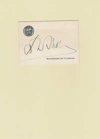
1933rif. 101284Between 1933 and 1937. 1933 and 1937. Fine. - A 2-1/2 high by 3-1/2 inch wide "Governor of Florida" calling card with the state seal embossed at the top left. Signed by Governor David Scholz. Near fine. The 26th Governor of Florida David Scholz 1891-1953 served from January 4 1933 to January 5 1937. Between 1933 and 1937. unknown
1811rif. 13130Pass Christian West Florida present-day Mississippi: June 4 1811. 3pp. on a single folio sheet addressed and docketed on verso of integral leaf postmarked at New Orleans on June 14. Original mailing folds a few fold line separations some with old small tape repairs light toning and foxing. Very good condition. An intriguing manuscript letter from Lieut. W.M. Littlejohn to Lieut. Charles Kitchell Gardner written from Pass Christian then in Orleans Territory now in Mississippi. Lieutenant Littlejohn was stationed at a United States Army cantonment at Pass Christian which was established in the aftermath of the rebellion in the Republic of West Florida in 1810. The army was dispatched to the area to keep the peace between the parties namely the United States Spain & factions supporting the Republic of West Florida. Littlejohn's letter opens with the news that his passage took him through Natchez Baton Rouge and New Orleans on his way to Pass Christian. Littlejohn then provides an informative then somewhat jarring assessment of Pass Christian: "This place is most delightfully situated on the sea shore & abounds with fish crabs & oysters -- it is also said to be the most healthy part of the country but that is counterbalanced by the total want of female society & the sea breeze & bathing which adds life & vigour wastes their precious gifts for nothing." Littlejohn then describes his quarters and doubles down on the lack of female companionship: "The cantonment is well built & convenient for the number it was intended for but not being sufficient for the last detachment we have to commence our own quarters which is no contemptible undertaking at this hot season with men unaccustomed to the climate & without tools to work with. This is the first time I have been in a country where there were no Ladies & on that account would prefer being at Washington where there is such elegant society." In the course of describing the setting weather general situation at the camp and so forth Littlejohn names the companies of troops present several of the officers some of the movements of said officers and more. He comments on the lack of significant activity noting that "there is not the smallest hope of any fighting with the Spaniards" though he does expect "a small skirmish between two great men" at some point. All artifacts of military activity from this era in Orleans Territory east of New Orleans are extremely scarce as is the New Orleans postmark from its pre-statehood period. June 4 unknown books
rif. ria9780471215783_inpHardback. New. New Book; Fast Shipping from UK; Not signed; Not First Edition; This book compiles the essential concepts for understanding designing and operating process control systems. Authoritative coverage addresses feedback controllers; cascade control; ratio override and selective control; block diagram hardcover
rif. ria9781941546802_inpPaperback / softback. New. New Book; Fast Shipping from UK; Not signed; Not First Edition; N/A paperback
1933rif. 3749388Madrid.: Suc. de Rivadeneyra. 1933. Paperback. Good. 18 cm. 255 p. Encuadernación en tapa blanda de editorial ilustrada. Alonso de la Florida. Prólogo biografía bibliografía y notas de Fernando de la Milla. Milla Fernando de la. 1895-¿1961 . [Suc. de Rivadeneyra]. paperback
193332 pages. Features: Front cover Thompson Valves ad salutes Pan American Airways and their 107 airliners; The Moment Distribution Method for Solving Continuous Frameworks; Compound Floating Ailerons; Army Lighter-Than-Air; The Zap Flap; Effect of Controllable Pitch on Airplane Performance; The World's Largest Autogiro - ferries between two Florida country clubs; The Bryce Fuel-Injection Pump; A Radio Transmitter for the Itinerant Flyer; Symposium on Arctic and Winter Flying; Traffic Control at the Alleghany Airport; The Switlik Parachute Chair; Racon Electric Co. photo ad shows crowd at Cleveland Air Races; and more. Unmarked with average wear. A sound vintage copy. Book
rif. 21880298-nnew. unknown
rif. 21880298like new. unknown
rif. A9780757515101Paperback / softback. New. paperback
rif. 37562938like new. unknown
rif. 37562938-nnew. unknown
rif. 1524992585-7-1Kendall Hunt Publishing. 3. Acceptable. The item might be beaten up but readable. May contain markings or highlighting as well as stains bent corners or any other major defect but the text is not obscured in any way. Kendall Hunt Publishing unknown