2 556 résultats
réf. ria9780470639177_inpHardback. New. New Book; Fast Shipping from UK; Not signed; Not First Edition; Psychology is of interest to academics from many fields as well as to the thousands of academic and clinical psychologists and general public who can't help but be interested in learning more about why humans think and behave as they d hardcover
1916réf. 40703Washington D.C.: Published by the United States Coast and Geodetic Survey 1916. Large folding nautical chart printed on heavy paper stock. Colored with minor wear. A rare coastal survey of Florida around Daytona including Ormond Beach Daytona Beach Port Orange New Smyrna Beach and Edgewater. Established by President Thomas Jefferson in 1807 as the Survey of the Coast the U.S. Coast and Geodetic Survey was the United States' first civilian scientific agency. This agency has followed its mission to survey the U.S. coastline create nautical charts of the coast and help increase maritime safety since its founding and has often played fascinating roles in significant chapters of U.S. history. It served in all theaters of the Civil War in the service of the Union Army and Navy pioneered acoustic exploration in the wake of the sinking of the Titanic and during WWI it worked to detect enemy submarines. In addition this agency worked to survey and produce detailed maps and renderings of the U.S. coast. These nautical survey maps commonly referred to as "T-sheets" provide fascinating insights into the history of the United States coastline which has and will continue to shift. These maps are the most important data source for understanding the physical and ecological characteristics of the U.S. shoreline. The present map is a highly detailed and accurate sea chart of the Daytona area and an important historical view of a developing Florida. Published by the United States Coast and Geodetic Survey unknown books
1916réf. 40703Washington D.C.: Published by the United States Coast and Geodetic Survey 1916. Large folding nautical chart printed on heavy paper stock. Colored with minor wear. A rare coastal survey of Florida around Daytona including Ormond Beach Daytona Beach Port Orange New Smyrna Beach and Edgewater. Established by President Thomas Jefferson in 1807 as the Survey of the Coast the U.S. Coast and Geodetic Survey was the United States' first civilian scientific agency. This agency has followed its mission to survey the U.S. coastline create nautical charts of the coast and help increase maritime safety since its founding and has often played fascinating roles in significant chapters of U.S. history. It served in all theaters of the Civil War in the service of the Union Army and Navy pioneered acoustic exploration in the wake of the sinking of the Titanic and during WWI it worked to detect enemy submarines. In addition this agency worked to survey and produce detailed maps and renderings of the U.S. coast. These nautical survey maps commonly referred to as "T-sheets" provide fascinating insights into the history of the United States coastline which has and will continue to shift. These maps are the most important data source for understanding the physical and ecological characteristics of the U.S. shoreline. The present map is a highly detailed and accurate sea chart of the Daytona area and an important historical view of a developing Florida. Published by the United States Coast and Geodetic Survey unknown
1916réf. 40724Washington D.C.: Published by the United States Coast and Geodetic Survey 1916. Large folding nautical chart printed on heavy paper stock. Colored. A rare original coastal survey of Florida from Tampa Bay to the Keys including Tampa St. Petersburg Sarasota Fort Myers Naples and of Northern Cuba including Havana. Established by President Thomas Jefferson in 1807 as the Survey of the Coast the U.S. Coast and Geodetic Survey was the United States' first civilian scientific agency. This agency has followed its mission to survey the U.S. coastline create nautical charts of the coast and help increase maritime safety since its founding and has often played fascinating roles in significant chapters of U.S. history. It served in all theaters of the Civil War in the service of the Union Army and Navy pioneered acoustic exploration in the wake of the sinking of the Titanic and during WWI it worked to detect enemy submarines. In addition this agency worked to survey and produce detailed maps and renderings of the U.S. coast. These nautical survey maps commonly referred to as "T-sheets" provide fascinating insights into the history of the United States coastline which has and will continue to shift. These maps are the most important data source for understanding the physical and ecological characteristics of the U.S. shoreline. The present map is a highly detailed and accurate sea chart of the Greater Florida Gulf region and an important historical view of a developing Florida. Published by the United States Coast and Geodetic Survey unknown books
1916réf. 40724Washington D.C.: Published by the United States Coast and Geodetic Survey 1916. Large folding nautical chart printed on heavy paper stock. Colored. A rare original coastal survey of Florida from Tampa Bay to the Keys including Tampa St. Petersburg Sarasota Fort Myers Naples and of Northern Cuba including Havana. Established by President Thomas Jefferson in 1807 as the Survey of the Coast the U.S. Coast and Geodetic Survey was the United States' first civilian scientific agency. This agency has followed its mission to survey the U.S. coastline create nautical charts of the coast and help increase maritime safety since its founding and has often played fascinating roles in significant chapters of U.S. history. It served in all theaters of the Civil War in the service of the Union Army and Navy pioneered acoustic exploration in the wake of the sinking of the Titanic and during WWI it worked to detect enemy submarines. In addition this agency worked to survey and produce detailed maps and renderings of the U.S. coast. These nautical survey maps commonly referred to as "T-sheets" provide fascinating insights into the history of the United States coastline which has and will continue to shift. These maps are the most important data source for understanding the physical and ecological characteristics of the U.S. shoreline. The present map is a highly detailed and accurate sea chart of the Greater Florida Gulf region and an important historical view of a developing Florida. Published by the United States Coast and Geodetic Survey unknown
1938réf. 57192New York: Sheridan House 1938. 8vo. 287 1 pp. Numerous photo plates colour maps on endpapers. Forest-green tweed boards black lettering colour maps on endpapers minor bumping head of spine slight bumping to couple corners w/ d.j. cover art of the Gypsy Waters under sail couple minor closed tears edgewear still VG/VG- copy. First edition of this author’s memoir detailing the rebuilding and outfitting of a Chesapeake Bay Bugeye ketch he renamed Gypsy Waters and the several adventures with his family to the Bahamas the Gulf Islands the Gulf lakes and rivers of Florida and more. Scarce in original dustjacket. Sheridan House, hardcover
196974 pages. Features: Savage's new lineup of .22's; Latest Products; The 50-year old Thompson is still the one they turn to; Light gauge lightweights from Remington - models 1100 and 870 now come in 28 and .410 gauges; Single shot hunting for Florida boars; Trail Guns; Take a Camera with you; The All-Around .25; Cook yourself some French Crick Ham; Hot .22 Wildcat; A Sporterized military rifle can cost you double; The Evolution of the holster; Potshots; Portfolio of hunting dogs; and more. Prior owner's stamp atop first page. Book
1908réf. 40737Washington D.C.: Published by the United States Coast and Geodetic Survey 1908. Large folding nautical chart printed on heavy paper stock. Colored. A rare original coastal survey of the Gulf coasts of Florida Alabama Mississippi and Louisiana including the Keys Fort Myers Sarasota Tampa Panama City Destin Pensacola Gulf Shores Mobile Biloxi Gulfport New Orleans and the Mississippi Delta. Established by President Thomas Jefferson in 1807 as the Survey of the Coast the U.S. Coast and Geodetic Survey was the United States' first civilian scientific agency. This agency has followed its mission to survey the U.S. coastline create nautical charts of the coast and help increase maritime safety since its founding and has often played fascinating roles in significant chapters of U.S. history. It served in all theaters of the Civil War in the service of the Union Army and Navy pioneered acoustic exploration in the wake of the sinking of the Titanic and during WWI it worked to detect enemy submarines. In addition this agency worked to survey and produce detailed maps and renderings of the U.S. coast. These nautical survey maps commonly referred to as "T-sheets" provide fascinating insights into the history of the United States coastline which has and will continue to shift. These maps are the most important data source for understanding the physical and ecological characteristics of the U.S. shoreline. The present map is a highly detailed and accurate sea chart of the coasts Florida Alabama Mississippi and Louisiana along the Gulf of Mexico and an important historical view of the developing states. Published by the United States Coast and Geodetic Survey unknown books
1908réf. 40737Washington D.C.: Published by the United States Coast and Geodetic Survey 1908. Large folding nautical chart printed on heavy paper stock. Colored. A rare original coastal survey of the Gulf coasts of Florida Alabama Mississippi and Louisiana including the Keys Fort Myers Sarasota Tampa Panama City Destin Pensacola Gulf Shores Mobile Biloxi Gulfport New Orleans and the Mississippi Delta. Established by President Thomas Jefferson in 1807 as the Survey of the Coast the U.S. Coast and Geodetic Survey was the United States' first civilian scientific agency. This agency has followed its mission to survey the U.S. coastline create nautical charts of the coast and help increase maritime safety since its founding and has often played fascinating roles in significant chapters of U.S. history. It served in all theaters of the Civil War in the service of the Union Army and Navy pioneered acoustic exploration in the wake of the sinking of the Titanic and during WWI it worked to detect enemy submarines. In addition this agency worked to survey and produce detailed maps and renderings of the U.S. coast. These nautical survey maps commonly referred to as "T-sheets" provide fascinating insights into the history of the United States coastline which has and will continue to shift. These maps are the most important data source for understanding the physical and ecological characteristics of the U.S. shoreline. The present map is a highly detailed and accurate sea chart of the coasts Florida Alabama Mississippi and Louisiana along the Gulf of Mexico and an important historical view of the developing states. Published by the United States Coast and Geodetic Survey unknown
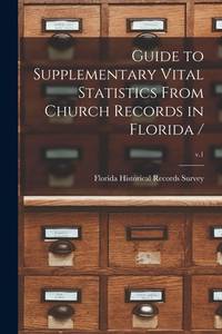
1988réf. 51535bdTallahassee: Florida Department of State 1988. Quarto softbound xiv 327 pp. Fine. Florida Department of State, 1988. paperback books
1963réf. GA001181Ino place: Florida South Chapter AIA. VG/ none. 1963. First edition. Wraps. 64 pages. Cover is loose. . Florida South Chapter AIA paperback
réf. B9781013614804Paperback / softback. New. paperback
réf. 0332966267.Ghardcover. Good. Access codes and supplements are not guaranteed with used items. May be an ex-library book. hardcover
1879réf. 37868Savannah: Morning News Steam Printing House 1879. 1879. FLORIDA GEORGIA. Sixth edition. 7 1/2" x 5" pictorial wrappers 80 pp. illustrated maps advertisements. A small green slip has been affixed to the title page advising the the Savannah Florida & Western Railway has purchased the Atlantic and Gulf Railroad Company and is now the successor. Folding map is of the Atlantic & Gulf Railroad and shows the lines from Savannah to Bainbridge spur to Albany and connections in Florida from Tallahassee to Baldwin and Jacksonville and to Cedar Key. The booklet describes stations and points of interest in southern Georgia and Florida as well as other railroads towns and points of interest in Florida and southern Georgia. Moderate wear to the spine rear cover becoming loose but still intact covers lightly soiled interior clean else a very good copy. Morning News Steam Printing House, 1879. unknown
réf. 1396041230.Ghardcover. Good. Access codes and supplements are not guaranteed with used items. May be an ex-library book. hardcover
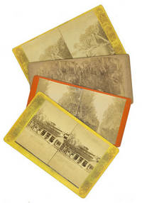
1880réf. 2391081880. Albumen prints on thick printed card curved corners. A trifle dusty one card with adhesive burn else images near fine. Albumen prints on thick printed card curved corners. Views include Palemettos on the St. John's River St. Augustine market and entrance to the city a staged hunting scene with a heron and alligator a canals and a wagon hitched to a cow titled "The Lightning Express; Or the Team of a Florida Cracker". unknown books
1880réf. 2391081880. Albumen prints on thick printed card curved corners. A trifle dusty one card with adhesive burn else images near fine. Albumen prints on thick printed card curved corners. Views include Palemettos on the St. John's River St. Augustine market and entrance to the city a staged hunting scene with a heron and alligator a canals and a wagon hitched to a cow titled "The Lightning Express; Or the Team of a Florida Cracker". unknown
réf. B305435-4Boca Raton 2006. 56pp. Prof. illus. Oblong 4to. Cloth. D.j. Boca Raton, 2006. hardcover books
réf. B305435-2Boca Raton 2006. 56pp. Prof. illus. Oblong 4to. Cloth. D.j. Boca Raton, 2006. hardcover books
réf. B305435-5Boca Raton 2006. 56pp. Prof. illus. Oblong 4to. Cloth. D.j. Boca Raton, 2006. hardcover books
réf. B305435-3Boca Raton 2006. 56pp. Prof. illus. Oblong 4to. Cloth. D.j. Boca Raton, 2006. hardcover books
réf. B305431-1New York/Boca Raton 2000. 10pp. 15 color illus. Oblong 4to. Wraps. New York/Boca Raton, [2000]. paperback books
réf. 0260021547.Ghardcover. Good. Access codes and supplements are not guaranteed with used items. May be an ex-library book. hardcover
réf. 0265776678.Gpaperback. Good. Access codes and supplements are not guaranteed with used items. May be an ex-library book. paperback
réf. 0260762954.Ghardcover. Good. Access codes and supplements are not guaranteed with used items. May be an ex-library book. hardcover