Richard FloridaBiblio.com
2.555 Ergebnisse
2004Best.-Nr. G041594886XI4N00Routledge 2004. Hardcover. Very Good. May have limited writing in cover pages. Pages are unmarked. ~ ThriftBooks: Read More Spend Less.Dust jacket quality is not guaranteed. Routledge hardcover
Best.-Nr. B9780415948876Paperback / softback. New. In this book Florida outlines how certain cities succeed in attracting members of the 'creative class' - people who work in information-age economic sectors and in industries driven by innovation and talent. paperback
Best.-Nr. 6339677Taylor & Francis Group . Papeback. New. pp. 208 Taylor & Francis Group unknown
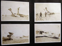
1918Best.-Nr. 030201Miami Florida: USMC 1918. Over 170 individual images including over 25 larger format 5" x 8" size depicting biplanes seaplanes in flight on the ground in wrecks and being salvaged. Photos pasted-on black album paper pages coming loose from the old post-and-cord binding covers loose and about gone; album approx. 7" x 11" size horizontal format. Photos also include various personnel including a few close-ups and of officers on base and at various duties with occasional views of the town and surrounding areas. Many of the aircraft are training biplanes of the Curtiss Jenny classification with several having their fuselage numbers clearly visible. A few of the photographs are professionally taken by the Miami photography studio of R.B. Hoit with his identifications in the plate. Several dramatic images show grounded and damaged planes and the results of air crashes. At least one of the smaller snapshots show a plane with the fuselage side-marking "Marine Flying Field Miami Florida." A few small 'targeting' photos show aircraft coming into attack range; others show the ground area. Several images give aircraft information "Ng Sea Plane - Curtiss Oxx 6 Motor" HIS - L Flying Boat Liberty Motor." There are also a few photos of blimps. A couple of photos show a downed aircraft in shallow water and being 'salvaged' by personnel floating around attempting to move the plane. Research indicates that "The U. S. Marine Corps leased the old Curtiss Flying Field from Glenn Curtiss. used for training Marine aviators and the first Marine Corps airfield solely used by Marine aircraft. The Marine Flying Field Miami was in operation from March 1918 until September 25 1919 located on the north side of the Miami River at approximately NW 33rd Avenue Miami. The First Marine Aviation Force commanded by Captain Cunningham was formed on April 15 1918 and the four squadrons of this Force designated "A" "B" "C" and "D" rapidly trained for combat flying Curtiss JN-4's and Thomas-Morse Scouts. They were augmented by some 80 Navy pilots who transferred to the Marine Corps in anticipation of a more rapid deployment to the war zone." Information on this USMC base from the Don Boyd pbas website page on this base who also credits Mark Lincoln In addition to the military photographs which are the majority there is a 1911-12 freshman H.S. class photo location unknown; family photographs a few train-schedules pasted-in along with a couple of handwritten notes one by a child; and travel scenery from town and country. A couple of images show a partially-completed Mt. Rushmore South Dakota with George Washington's features the only visible portrait; with other Western America scenery forest & lake vistas mountain ranges; and photographs of folks camping hunting & fishing and the results. A few of the photos edge-and-corner chipped; mostly all in good condition. . Photograph Album. Soft Cover. Good. USMC paperback
Best.-Nr. 012664750X.Ghardcover. Good. Access codes and supplements are not guaranteed with used items. May be an ex-library book. hardcover
1975Best.-Nr. 86086Academic Press. Good/No Dust Wrapper. 1975. Hard Cover. 012664750X T11 . Academic Press hardcover
1917Best.-Nr. 40682Washington D.C.: Published by the United States Coast and Geodetic Survey 1917. Nautical chart printed on heavy paper stock. Colored. A rare coastal survey of the Pensacola area including Destin Fort Walton Santa Rosa Island and Pensacola Beach. Established by President Thomas Jefferson in 1807 as the Survey of the Coast the U.S. Coast and Geodetic Survey was the United States' first civilian scientific agency. This agency has followed its mission to survey the U.S. coastline create nautical charts of the coast and help increase maritime safety since its founding and has often played fascinating roles in significant chapters of U.S. history. It served in all theaters of the Civil War in the service of the Union Army and Navy pioneered acoustic exploration in the wake of the sinking of the Titanic and during WWI it worked to detect enemy submarines. In addition this agency worked to survey and produce detailed maps and renderings of the U.S. coast. These nautical survey maps commonly referred to as "T-sheets" provide fascinating insights into the history of the United States coastline which has and will continue to shift. These maps are the most important data source for understanding the physical and ecological characteristics of the U.S. shoreline. The present map is a highly detailed and accurate sea chart of the Pensacola area and an important historical view of a developing Florida. Published by the United States Coast and Geodetic Survey unknown books
1922Best.-Nr. 40698Washington D.C.: Published by the United States Coast and Geodetic Survey 1922. Large folding nautical chart printed on heavy paper stock. Colored with minor wear. A rare coastal survey of the Florida coast from Fort Walton Beach to Panama City Beach including Destin Grayton Beach Seaside Alys Beach Rosemary Beach and Laguna Beach. Established by President Thomas Jefferson in 1807 as the Survey of the Coast the U.S. Coast and Geodetic Survey was the United States' first civilian scientific agency. This agency has followed its mission to survey the U.S. coastline create nautical charts of the coast and help increase maritime safety since its founding and has often played fascinating roles in significant chapters of U.S. history. It served in all theaters of the Civil War in the service of the Union Army and Navy pioneered acoustic exploration in the wake of the sinking of the Titanic and during WWI it worked to detect enemy submarines. In addition this agency worked to survey and produce detailed maps and renderings of the U.S. coast. These nautical survey maps commonly referred to as "T-sheets" provide fascinating insights into the history of the United States coastline which has and will continue to shift. These maps are the most important data source for understanding the physical and ecological characteristics of the U.S. shoreline. The present map is a highly detailed and accurate sea chart of 30A area in Florida and an important historical view of the developing state. Published by the United States Coast and Geodetic Survey unknown books
1917Best.-Nr. 40682Washington D.C.: Published by the United States Coast and Geodetic Survey 1917. Nautical chart printed on heavy paper stock. Colored. A rare coastal survey of the Pensacola area including Destin Fort Walton Santa Rosa Island and Pensacola Beach. Established by President Thomas Jefferson in 1807 as the Survey of the Coast the U.S. Coast and Geodetic Survey was the United States' first civilian scientific agency. This agency has followed its mission to survey the U.S. coastline create nautical charts of the coast and help increase maritime safety since its founding and has often played fascinating roles in significant chapters of U.S. history. It served in all theaters of the Civil War in the service of the Union Army and Navy pioneered acoustic exploration in the wake of the sinking of the Titanic and during WWI it worked to detect enemy submarines. In addition this agency worked to survey and produce detailed maps and renderings of the U.S. coast. These nautical survey maps commonly referred to as "T-sheets" provide fascinating insights into the history of the United States coastline which has and will continue to shift. These maps are the most important data source for understanding the physical and ecological characteristics of the U.S. shoreline. The present map is a highly detailed and accurate sea chart of the Pensacola area and an important historical view of a developing Florida. Published by the United States Coast and Geodetic Survey unknown
1922Best.-Nr. 40698Washington D.C.: Published by the United States Coast and Geodetic Survey 1922. Large folding nautical chart printed on heavy paper stock. Colored with minor wear. A rare coastal survey of the Florida coast from Fort Walton Beach to Panama City Beach including Destin Grayton Beach Seaside Alys Beach Rosemary Beach and Laguna Beach. Established by President Thomas Jefferson in 1807 as the Survey of the Coast the U.S. Coast and Geodetic Survey was the United States' first civilian scientific agency. This agency has followed its mission to survey the U.S. coastline create nautical charts of the coast and help increase maritime safety since its founding and has often played fascinating roles in significant chapters of U.S. history. It served in all theaters of the Civil War in the service of the Union Army and Navy pioneered acoustic exploration in the wake of the sinking of the Titanic and during WWI it worked to detect enemy submarines. In addition this agency worked to survey and produce detailed maps and renderings of the U.S. coast. These nautical survey maps commonly referred to as "T-sheets" provide fascinating insights into the history of the United States coastline which has and will continue to shift. These maps are the most important data source for understanding the physical and ecological characteristics of the U.S. shoreline. The present map is a highly detailed and accurate sea chart of 30A area in Florida and an important historical view of the developing state. Published by the United States Coast and Geodetic Survey unknown
Best.-Nr. 1527830837.Gpaperback. Good. Access codes and supplements are not guaranteed with used items. May be an ex-library book. paperback
199080 pages. Features: Ray Kellogg; Nelson Nichols; Santa Maria Show; Let's Carve! - Noah's Ark; Curious Copy Cats; Livonia Show; Carving Dragons; Quilceda Carvers; Walter Henry Lueth; Kaw Valley Show; Eggheads; Florida Carousel Art Auction; Don and Frances Pickett; East Texas Show; Seawater Carvers Club of Austell, Georgia; Woodcarving Rendezvous V; Quassy's Merry-Go-Round; Carved Floral Reliefs; Burning Techniques; Ideal Walking Stick; and more. Moderate wear. Clean and unmarked. Creases to front cover. A sound copy. Magazine
2025Best.-Nr. x-1009363530Cambridge University Press 2025. Paperback. New. 2nd revised edition edition. 726 pages. 8.50x1.45x11.00 inches. Cambridge University Press paperback
2025Best.-Nr. x-1009363557Cambridge University Press 2025. Hardcover. New. 2nd revised edition edition. 726 pages. 8.50x1.50x11.00 inches. Cambridge University Press hardcover
Best.-Nr. 1396152458.Ghardcover. Good. Access codes and supplements are not guaranteed with used items. May be an ex-library book. hardcover
Best.-Nr. 0656375361.Ghardcover. Good. Access codes and supplements are not guaranteed with used items. May be an ex-library book. hardcover
1919Best.-Nr. 40687Washington D.C.: Published by the United States Coast and Geodetic Survey 1919. Nautical chart printed on heavy paper stock. Colored. A rare coastal survey of the Florida Georgia and South Carolina including Daytona Palm Coast St. Augustine Ponte Vedra Amelia Island Jacksonville Fernandina Jekyll Island St. Simons Sea Island Tybee Savannah Hilton Head Kiawah and Folly Beach. Established by President Thomas Jefferson in 1807 as the Survey of the Coast the U.S. Coast and Geodetic Survey was the United States' first civilian scientific agency. This agency has followed its mission to survey the U.S. coastline create nautical charts of the coast and help increase maritime safety since its founding and has often played fascinating roles in significant chapters of U.S. history. It served in all theaters of the Civil War in the service of the Union Army and Navy pioneered acoustic exploration in the wake of the sinking of the Titanic and during WWI it worked to detect enemy submarines. In addition this agency worked to survey and produce detailed maps and renderings of the U.S. coast. These nautical survey maps commonly referred to as "T-sheets" provide fascinating insights into the history of the United States coastline which has and will continue to shift. These maps are the most important data source for understanding the physical and ecological characteristics of the U.S. shoreline. The present map is a highly detailed and accurate sea chart of the coasts of Florida Georgia and Alabama and an important historical view of the developing states. Published by the United States Coast and Geodetic Survey unknown books
1919Best.-Nr. 40687Washington D.C.: Published by the United States Coast and Geodetic Survey 1919. Nautical chart printed on heavy paper stock. Colored. A rare coastal survey of the Florida Georgia and South Carolina including Daytona Palm Coast St. Augustine Ponte Vedra Amelia Island Jacksonville Fernandina Jekyll Island St. Simons Sea Island Tybee Savannah Hilton Head Kiawah and Folly Beach. Established by President Thomas Jefferson in 1807 as the Survey of the Coast the U.S. Coast and Geodetic Survey was the United States' first civilian scientific agency. This agency has followed its mission to survey the U.S. coastline create nautical charts of the coast and help increase maritime safety since its founding and has often played fascinating roles in significant chapters of U.S. history. It served in all theaters of the Civil War in the service of the Union Army and Navy pioneered acoustic exploration in the wake of the sinking of the Titanic and during WWI it worked to detect enemy submarines. In addition this agency worked to survey and produce detailed maps and renderings of the U.S. coast. These nautical survey maps commonly referred to as "T-sheets" provide fascinating insights into the history of the United States coastline which has and will continue to shift. These maps are the most important data source for understanding the physical and ecological characteristics of the U.S. shoreline. The present map is a highly detailed and accurate sea chart of the coasts of Florida Georgia and Alabama and an important historical view of the developing states. Published by the United States Coast and Geodetic Survey unknown
Best.-Nr. ria9780271063836_inpHardback. New. New Book; Fast Shipping from UK; Not signed; Not First Edition; Traces an epistemological legacy from Romantic and Victorian ecological literature to modern scientific ecology. Investigates two essential and contrasting paradigms of nature that continue to be debated today. hardcover
Best.-Nr. DADAX1538118998Rowman & Littlefield Publishers 2018-11-02. Third. hardcover. New. 6.30x0.88x9.25. Buy with confidence. Excellent Customer Service & Return policy. Rowman & Littlefield Publishers hardcover
1997Best.-Nr. 2410020282ybvkNorfolk, UK; 100th Bomb Group Memorial Museum / Thorpe Abbotts, 1997. vii, 244 (2 blue) pages, photographically illustrated throughout. - Publisher's blue gilt-titled hardcover with colour-illustr. dustjacket; 8vo.(ca. 31 x 21 cm; ca. 1,229 kg.).
Best.-Nr. 1391494768.Ghardcover. Good. Access codes and supplements are not guaranteed with used items. May be an ex-library book. hardcover
Best.-Nr. 43113882like new. unknown
Best.-Nr. 43113882-nnew. unknown
Best.-Nr. B9780788420085Paperback / softback. New. paperback